HoarfrostHubb
-
Posts
58,470 -
Joined
-
Last visited
Content Type
Profiles
Blogs
Forums
American Weather
Media Demo
Store
Gallery
Everything posted by HoarfrostHubb
-

The last hurrah? Putting all the eggs in the Tuesday 3/14 basket
HoarfrostHubb replied to Ginx snewx's topic in New England
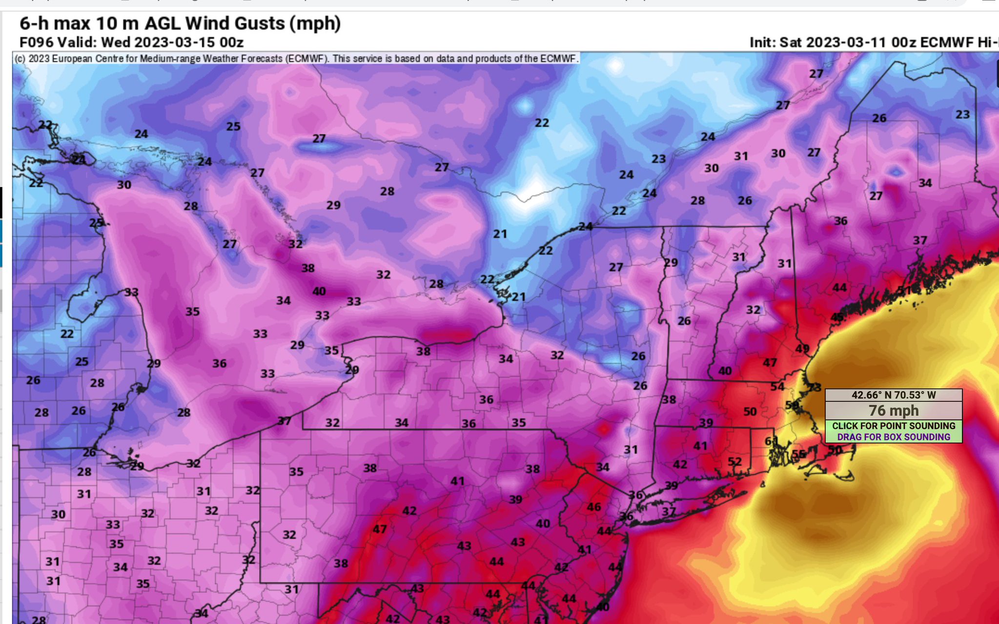
This would leave a mark
-
The last hurrah? Putting all the eggs in the Tuesday 3/14 basket
HoarfrostHubb replied to Ginx snewx's topic in New England
Concerns I have… dry slot. Ratios. This won’t be 10:1 for a lot of it -
The last hurrah? Putting all the eggs in the Tuesday 3/14 basket
HoarfrostHubb replied to Ginx snewx's topic in New England
The the snow stack on your head -
The last hurrah? Putting all the eggs in the Tuesday 3/14 basket
HoarfrostHubb replied to Ginx snewx's topic in New England
Book a room at Great Wolf Lodge. -
March 10-11 light snow threat for SW New England.
HoarfrostHubb replied to Sey-Mour Snow's topic in New England
2.0” of complete fluff here at 1k in N central Mass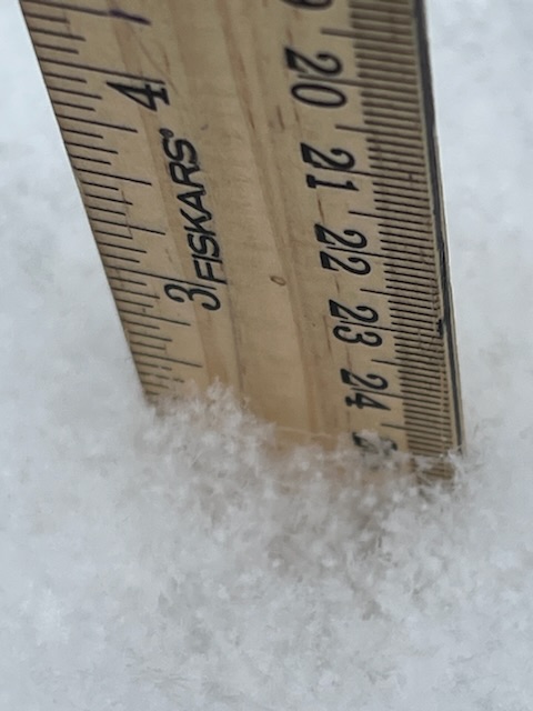

-
The last hurrah? Putting all the eggs in the Tuesday 3/14 basket
HoarfrostHubb replied to Ginx snewx's topic in New England
Wa wa Wachusett. -
The last hurrah? Putting all the eggs in the Tuesday 3/14 basket
HoarfrostHubb replied to Ginx snewx's topic in New England
You gonna get nailed -
The last hurrah? Putting all the eggs in the Tuesday 3/14 basket
HoarfrostHubb replied to Ginx snewx's topic in New England
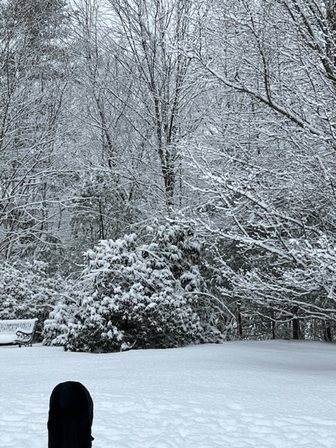
Good morning sunshine!!! -
The last hurrah? Putting all the eggs in the Tuesday 3/14 basket
HoarfrostHubb replied to Ginx snewx's topic in New England
It made for some lol-tastic weenie maps -
New England Met Winter 2022-2023 Banter
HoarfrostHubb replied to HoarfrostHubb's topic in New England
Hey @HIPPYVALLEY Hawk & Reed Sat night. Enter the Haggis!!!! -
The last hurrah? Putting all the eggs in the Tuesday 3/14 basket
HoarfrostHubb replied to Ginx snewx's topic in New England
It does a cut little jog along the coast from Hull to Newburyport. -
The last hurrah? Putting all the eggs in the Tuesday 3/14 basket
HoarfrostHubb replied to Ginx snewx's topic in New England
I miss the Super Swiss from a couple of years ago -
The last hurrah? Putting all the eggs in the Tuesday 3/14 basket
HoarfrostHubb replied to Ginx snewx's topic in New England
I hate how it does that jump on Tropical Tidbits Goes right up Narragansett Bay. Still would work for here, but it is hauling -
The last hurrah? Putting all the eggs in the Tuesday 3/14 basket
HoarfrostHubb replied to Ginx snewx's topic in New England
That would be Hubbardston -
The last hurrah? Putting all the eggs in the Tuesday 3/14 basket
HoarfrostHubb replied to Ginx snewx's topic in New England
-
The last hurrah? Putting all the eggs in the Tuesday 3/14 basket
HoarfrostHubb replied to Ginx snewx's topic in New England
Definitely something to look for. -
The last hurrah? Putting all the eggs in the Tuesday 3/14 basket
HoarfrostHubb replied to Ginx snewx's topic in New England
That would be preferable -
The last hurrah? Putting all the eggs in the Tuesday 3/14 basket
HoarfrostHubb replied to Ginx snewx's topic in New England
Somewhere in CT, a bald, emaciated man is stirring in his sleep -
The last hurrah? Putting all the eggs in the Tuesday 3/14 basket
HoarfrostHubb replied to Ginx snewx's topic in New England
We should have it all sorted out by 18z…Monday -
The last hurrah? Putting all the eggs in the Tuesday 3/14 basket
HoarfrostHubb replied to Ginx snewx's topic in New England
I think they are having a big staff party. -
The last hurrah? Putting all the eggs in the Tuesday 3/14 basket
HoarfrostHubb replied to Ginx snewx's topic in New England
Whatever algorithm Wunderground uses for their app is giving me 4 inches total. Lol. -
The last hurrah? Putting all the eggs in the Tuesday 3/14 basket
HoarfrostHubb replied to Ginx snewx's topic in New England
Talk about a loop -
The last hurrah? Putting all the eggs in the Tuesday 3/14 basket
HoarfrostHubb replied to Ginx snewx's topic in New England
Any more looping going on? I have not seen it presented like that today -
The last hurrah? Putting all the eggs in the Tuesday 3/14 basket
HoarfrostHubb replied to Ginx snewx's topic in New England
Wa-wa-wachusett -
The last hurrah? Putting all the eggs in the Tuesday 3/14 basket
HoarfrostHubb replied to Ginx snewx's topic in New England
Over 5" in RI