HoarfrostHubb
-
Posts
58,470 -
Joined
-
Last visited
Content Type
Profiles
Blogs
Forums
American Weather
Media Demo
Store
Gallery
Everything posted by HoarfrostHubb
-

The last hurrah? Putting all the eggs in the Tuesday 3/14 basket
HoarfrostHubb replied to Ginx snewx's topic in New England
Flakes started near Walmart in Gardner for me. Mix of wet and flakes now. -
The last hurrah? Putting all the eggs in the Tuesday 3/14 basket
HoarfrostHubb replied to Ginx snewx's topic in New England
Cut back a little bit... but mostly noise (in my area at least) -
The last hurrah? Putting all the eggs in the Tuesday 3/14 basket
HoarfrostHubb replied to Ginx snewx's topic in New England
I wouldn't wipe my nose with the RAP -
The last hurrah? Putting all the eggs in the Tuesday 3/14 basket
HoarfrostHubb replied to Ginx snewx's topic in New England
It is so tenuous. While not a similar system, I'm wondering if the degree of difficulty with forecasting this is similar to the October 2011 storm (someone mentioned it earlier, but for a different reason). Stupid freezing point of water... -
The last hurrah? Putting all the eggs in the Tuesday 3/14 basket
HoarfrostHubb replied to Ginx snewx's topic in New England
Should not look at the CMC -
The last hurrah? Putting all the eggs in the Tuesday 3/14 basket
HoarfrostHubb replied to Ginx snewx's topic in New England
Sweet look
-
The last hurrah? Putting all the eggs in the Tuesday 3/14 basket
HoarfrostHubb replied to Ginx snewx's topic in New England
Plus Yen Yen & Wendy's!!! Aldi's is coming to Timpany I guess. That's good. Enjoy the electricity while we have it -
The last hurrah? Putting all the eggs in the Tuesday 3/14 basket
HoarfrostHubb replied to Ginx snewx's topic in New England
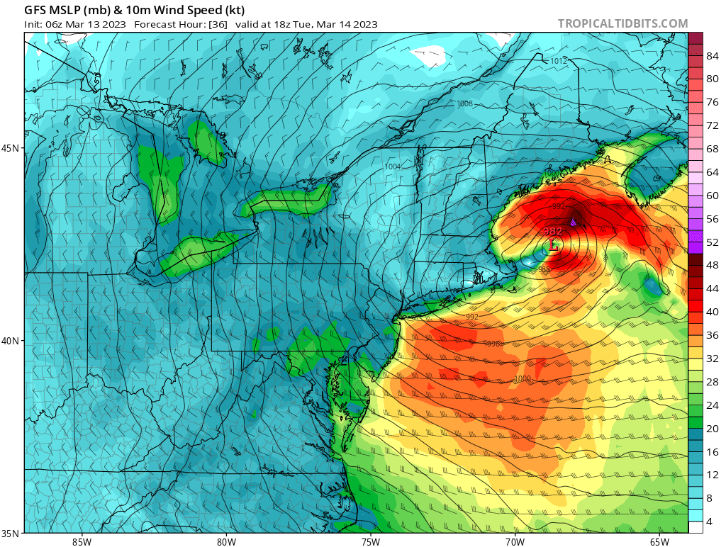
Is that model of any use whatsoever? If so... dang... -
The last hurrah? Putting all the eggs in the Tuesday 3/14 basket
HoarfrostHubb replied to Ginx snewx's topic in New England
Yeah... I mentioned the Colonial in a later post -
The last hurrah? Putting all the eggs in the Tuesday 3/14 basket
HoarfrostHubb replied to Ginx snewx's topic in New England
Anyone have a NBM Koochie or 10:1 clown? -
The last hurrah? Putting all the eggs in the Tuesday 3/14 basket
HoarfrostHubb replied to Ginx snewx's topic in New England
Or some diseases... But the Friendly's next door is fine -
The last hurrah? Putting all the eggs in the Tuesday 3/14 basket
HoarfrostHubb replied to Ginx snewx's topic in New England
I would avoid that place. Colonial Inn is much better. Plus it has a resturant and pool. Located right off 140. A bit higher as well I think -
The last hurrah? Putting all the eggs in the Tuesday 3/14 basket
HoarfrostHubb replied to Ginx snewx's topic in New England
For those looking to chase, Great Wolf Lodge in Fitchburg/Princeton is fun for the family. Prime spot for this. Plus they have a resturant/bar etc. Kinda $$$ though They have backup power as well -
The last hurrah? Putting all the eggs in the Tuesday 3/14 basket
HoarfrostHubb replied to Ginx snewx's topic in New England
NAM with 15" on snow by 10AM tomorrow for me... ummmm... -
The last hurrah? Putting all the eggs in the Tuesday 3/14 basket
HoarfrostHubb replied to Ginx snewx's topic in New England
Biggest question I have is how far east along that corridor does it stay substantial... Leominster? Harvard? -
The last hurrah? Putting all the eggs in the Tuesday 3/14 basket
HoarfrostHubb replied to Ginx snewx's topic in New England
Wa wa Wachusett With Ginger Libations all around -
The last hurrah? Putting all the eggs in the Tuesday 3/14 basket
HoarfrostHubb replied to Ginx snewx's topic in New England
MNGW -
The last hurrah? Putting all the eggs in the Tuesday 3/14 basket
HoarfrostHubb replied to Ginx snewx's topic in New England
Nice tertiary jack over Ray -
The last hurrah? Putting all the eggs in the Tuesday 3/14 basket
HoarfrostHubb replied to Ginx snewx's topic in New England
Ranges
-
The last hurrah? Putting all the eggs in the Tuesday 3/14 basket
HoarfrostHubb replied to Ginx snewx's topic in New England

-
The last hurrah? Putting all the eggs in the Tuesday 3/14 basket
HoarfrostHubb replied to Ginx snewx's topic in New England
I doubt they get 34. But 24 seems possible. Timing isn’t great -
The last hurrah? Putting all the eggs in the Tuesday 3/14 basket
HoarfrostHubb replied to Ginx snewx's topic in New England
Pretty amazing how just about every run of every model dumps here. I’m trying to think of anything that wavered -
The last hurrah? Putting all the eggs in the Tuesday 3/14 basket
HoarfrostHubb replied to Ginx snewx's topic in New England
Wa wa Wachusett -
The last hurrah? Putting all the eggs in the Tuesday 3/14 basket
HoarfrostHubb replied to Ginx snewx's topic in New England
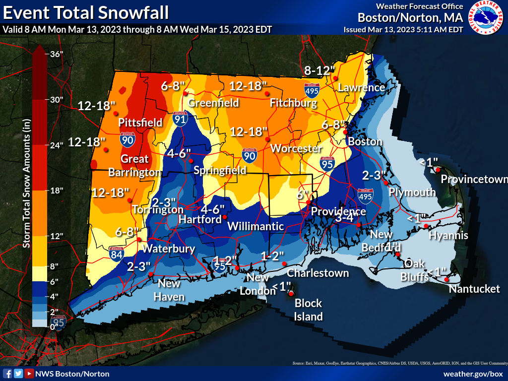
Some dude made this map… -
The last hurrah? Putting all the eggs in the Tuesday 3/14 basket
HoarfrostHubb replied to Ginx snewx's topic in New England
Any deets on that second sentence?