

mayjawintastawm
-
Posts
1,564 -
Joined
-
Last visited
Content Type
Profiles
Blogs
Forums
American Weather
Media Demo
Store
Gallery
Everything posted by mayjawintastawm
-
Mountain West Discussion
mayjawintastawm replied to mayjawintastawm's topic in Central/Western States
Quite the deluge here, with a 3-day total of 0.04" (0.08" for the month). -
Mountain West Discussion
mayjawintastawm replied to mayjawintastawm's topic in Central/Western States
Airmass has cooled and stabilized north of the Palmer Divide. So convective possibility has disappeared. Swing and a miss for strike one. Need something to generate lift, or upslope, or something. -
Mountain West Discussion
mayjawintastawm replied to mayjawintastawm's topic in Central/Western States
Will be interesting to see what happens with this pattern change. Over the last 60 days we've had 0.34" of rain. Ground moisture in non-irrigated spots is nonexistent. 40+ year old trees in the neighborhood are very stressed and some are dying. -
Mountain West Discussion
mayjawintastawm replied to mayjawintastawm's topic in Central/Western States
Great and simple analysis. I'm guessing the moisture trends are messier but summers certainly seem to have dried since we moved here in 2010. -
Mountain West Discussion
mayjawintastawm replied to mayjawintastawm's topic in Central/Western States
COCORAHS agrees with most of the Denver Metro receiving a trace or less over the last 3 days. We got a trace. Incredible how the forecasts have busted low so much, and so consistently, the last several weeks within the 470 circle. -
Mountain West Discussion
mayjawintastawm replied to mayjawintastawm's topic in Central/Western States
We've been able to open windows and turn a big fan on most nights, but last night the temp went down to 68 at 11 PM but rose after that, 73 at 6 AM. Stuffy. One of many reasons I don't live in AZ. -
Mountain West Discussion
mayjawintastawm replied to mayjawintastawm's topic in Central/Western States
Glad I was on the East Coast. We finished July with 0.30" rain total at my house. -
Mountain West Discussion
mayjawintastawm replied to mayjawintastawm's topic in Central/Western States
Interesting. There must be a subtle terrain feature right between I-225 and E-470 and south that creates a narrow zone of convergence. We got skunked again, 0.02" with radar similar to Tuesday. COCORAHS illustrates: (24 hrs ending 7 AM today)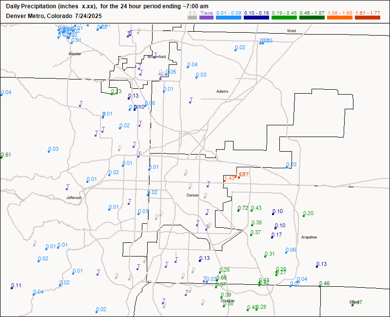
-
Mountain West Discussion
mayjawintastawm replied to mayjawintastawm's topic in Central/Western States
Yes, we finally got 0.17" which feels like a downpour. Monthly total 0.23". -
Mountain West Discussion
mayjawintastawm replied to mayjawintastawm's topic in Central/Western States
OK, so here's what I'm talking about: current radar, blue dot is my house.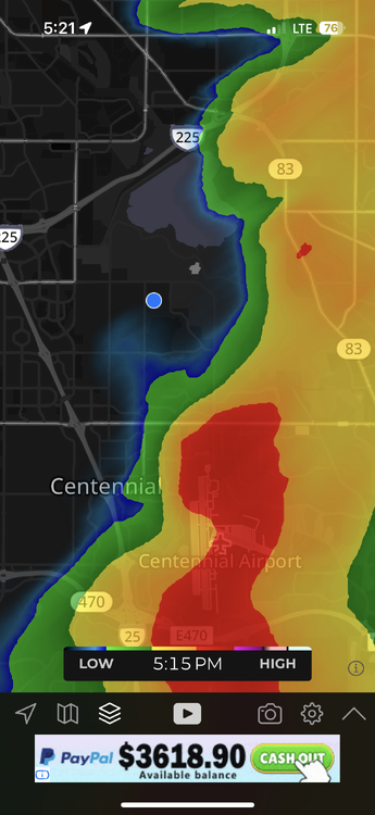
-
Mountain West Discussion
mayjawintastawm replied to mayjawintastawm's topic in Central/Western States
May 20-June 25 were remarkably wet, so on average we are unremarkable in the SE half of the Metro- it's more that "dry begets dry" all over again once it gets started. -
Mountain West Discussion
mayjawintastawm replied to mayjawintastawm's topic in Central/Western States
Yeah between yesterday and today we wound up with 0.05". I feel like I'm at a Rockies game. Snatching defeat from the jaws of victory EVERY SINGLE @%#$^&* TIME. -
Mountain West Discussion
mayjawintastawm replied to mayjawintastawm's topic in Central/Western States
Super dry at our house this month, with only 0.02" rain- all the storms have gone north and south. Hoping for monsoon moisture to finally hit us a bit over the next week! -
Mountain West Discussion
mayjawintastawm replied to mayjawintastawm's topic in Central/Western States
0.72" rain yesterday, we had tiny hail but the plants did OK. Really feels monsoony out there, DPs in the mid to upper 50s. Nice! -
Mountain West Discussion
mayjawintastawm replied to mayjawintastawm's topic in Central/Western States
I'll take it over the sauna that we currently have. 98/42 at 5 PM MT IMBY. 98/20 at Buckley AFB nearby...6% RH will dry you out in a hurry. -
Mountain West Discussion
mayjawintastawm replied to mayjawintastawm's topic in Central/Western States
We seem to have threaded the needle with all 3 rounds so far, with only 0.03" at the house, but we'll see what the rest of the afternoon brings. Car is inside and tomatoes are under the porch, so that pretty much guarantees quiet weather. -
Mountain West Discussion
mayjawintastawm replied to mayjawintastawm's topic in Central/Western States
Looks like south and northwest were the winners this time. We had 0.60". From COCORAHS
-
Mountain West Discussion
mayjawintastawm replied to mayjawintastawm's topic in Central/Western States
We really caught up yesterday with 2.64" of rain in 24 hours. Closing in on 4 inches for the month, who knew? Then again, May is often the surprise flood month- 2 years ago we had close to 6 inches in a day and a half, that washed out the road over Cherry Creek in the state park for close to a year. Same road had a foot of flowing water over it in the same place this morning. -
Mountain West Discussion
mayjawintastawm replied to mayjawintastawm's topic in Central/Western States
Got 0.8" of rain in the last 20 minutes along with a good bit of small hail. Rain rate peaked at 3.35 inches/hour. Localized flooding, of course. -
Mountain West Discussion
mayjawintastawm replied to mayjawintastawm's topic in Central/Western States
This is possibly the smallest severe thunderstorm watch I've ever seen. Pretty cool out now, though humid, doesn't feel like a severe weather day, though there's one supercell out near Kiowa (Kiowa has a semi-permanent supercell, I think).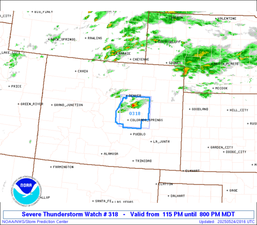
-
Mountain West Discussion
mayjawintastawm replied to mayjawintastawm's topic in Central/Western States
Just got back from a couple hours on the bike near Centennial and saw at least 2 of those storms form right overhead and move quickly to the northeast. They're going from nothing to nasty/starting to rotate in 30 minutes. Missed getting hailed on (0.5-0.6" hail at our house) by about 10 minutes ... one more reason to wear a helmet. -
Mountain West Discussion
mayjawintastawm replied to mayjawintastawm's topic in Central/Western States
1.01"- can't complain too much. All the showers today missed one direction or the other. -
Mountain West Discussion
mayjawintastawm replied to mayjawintastawm's topic in Central/Western States
Rain may not be continuous with this one, but the showers have been potent. The conveyor belt worked its way north during the morning and we're on the very north edge, having had 0.74" rain in 8 hours. Looks to continue for a while so we may get our 1" after all. 38-39 F at 5650'. Brr. -
Mountain West Discussion
mayjawintastawm replied to mayjawintastawm's topic in Central/Western States
Here we go again. What can you do when all the models say you'll get 1"+, 12 hours before the event. Gonna be a long fire season. Forecast for Sunday: Rain late. Measured precip: zero. Forecast for Monday: Rain late. Measured precip: zero. Today the closest precip is about 70 miles south. -
Mountain West Discussion
mayjawintastawm replied to mayjawintastawm's topic in Central/Western States
Given recent May-hem, I wouldn't be surprised. Hot today though! Was 79 a few minutes ago, wonder if it'll break 80 before the clouds take over.

