mayjawintastawm
-
Posts
1,557 -
Joined
-
Last visited
Content Type
Profiles
Blogs
Forums
American Weather
Media Demo
Store
Gallery
Everything posted by mayjawintastawm
-
Wondering what blizzard criteria for Southern CA would be... 1 or more snowflakes visible within 1/4 mile and temps+winds making it somewhat uncomfortable to wear shorts.
-
Indeed. -10 here and forecast was +2.
-
So, the "low end forecast" for snow from this "storm" was 2.2 inches. We got 0.8", if I lean the ruler over just right. And there were supposed to be some wind gusts. Max wind at our house was maybe 12 MPH. Well. It is cold like was forecast.
-
OK so this is amazing. Never in my 20+ years of reading AFDs have I seen a poem in one. Here is tonight's from a likely bored forecaster named Rodriguez at BOU: so cool. Area Forecast Discussion National Weather Service Denver/Boulder CO 848 PM MST Fri Feb 17 2023 .UPDATE... Issued at 819 PM MST Fri Feb 17 2023 `Twas a day of photogenic clouds, and it drew the weather weenie crowds. They come in search of information, But I am a man of evasion. In my brain, emptiness abounds.
-
Ratios are all over the place, but generally 10:1 would be conservative. For example, the 6.3" we got here total over the last storm was from 0.36" of water (17.5:1 average) and I think that was a fairly typical storm. On the other hand, the 11ish inches we got right after Christmas had well over an inch of water in it, probably around 1.3 inches (8.5:1) and maybe even a bit more. That was definitely heavier than usual. Looking at DEN from Dec 2021-Mar 2022 (excluding a rainstorm in late March), there was 46.7" of snow with 2.88" water, so average 16.2:1. My sense in our 13 winters here is that the frequent "misses" are more from QPF that doesn't pan out as predicted. I'm guessing WY would be drier and colder than here.
-
We've been under this really narrow band off and on all afternoon... 5.4" so far from the storm, the last 2" super-low density snow. Could probably do the driveway with a leaf blower, mostly.
-
Things bumped back up a little for a light to moderate impact event with 0.25-0.5" WE tonight through tomorrow night.
-
Yawn. Grumble. Getting pretty dry again, under half an inch of water since 1/1 here.
-
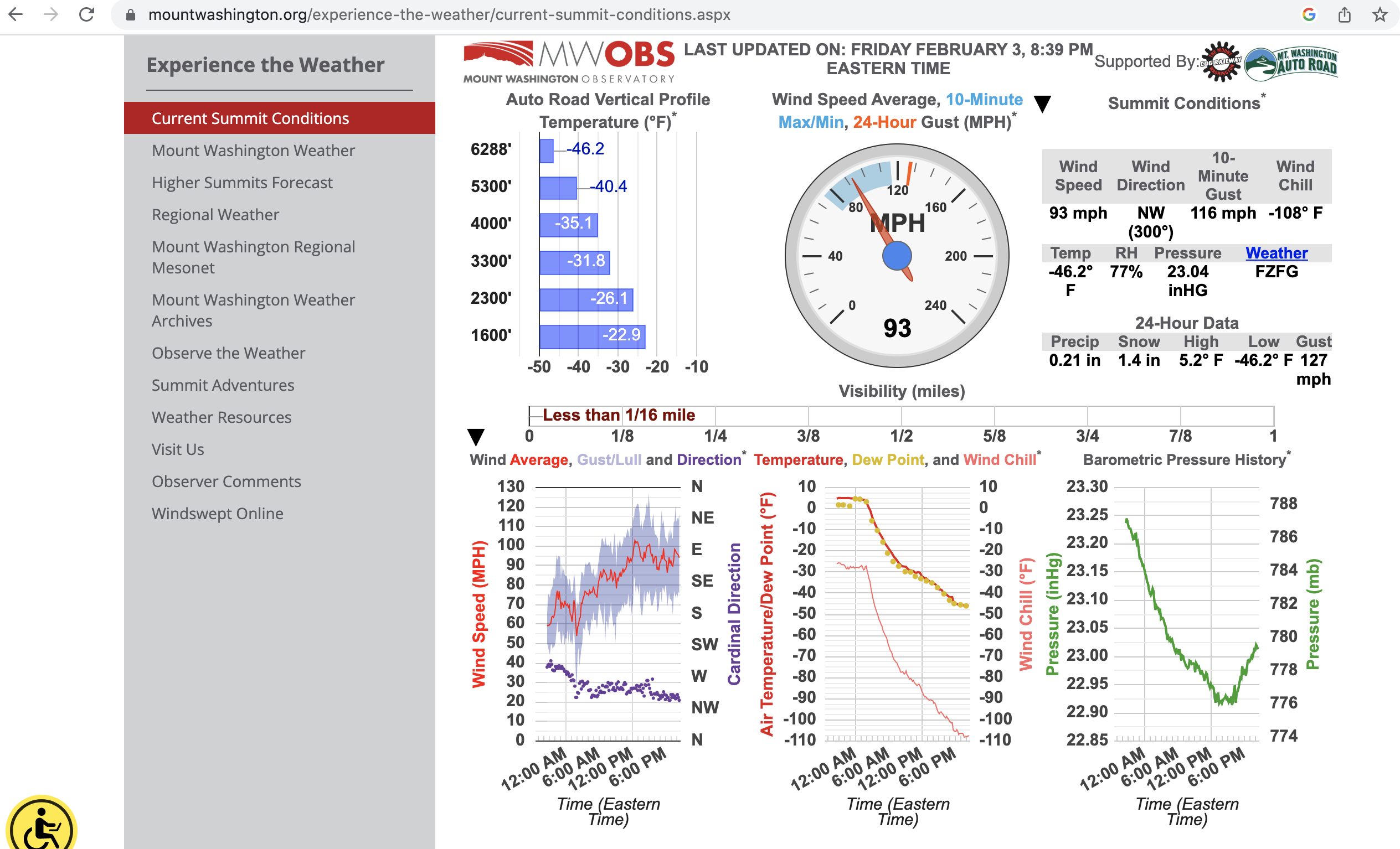
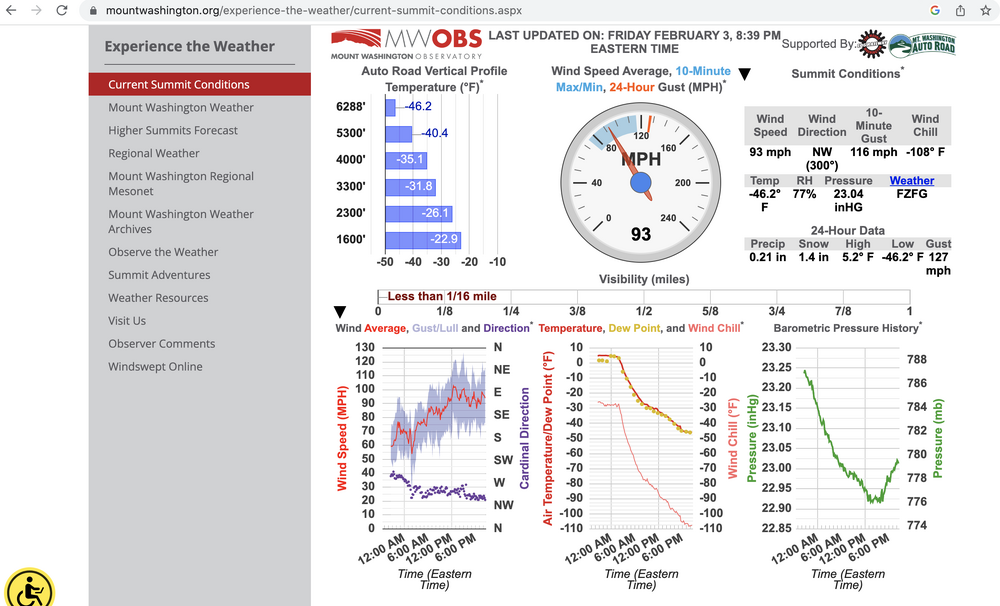
In case anyone thought today was too warm here (+60 F at my house, first in 2 mos): from Mount Washington, NH, a paltry 6288 feet above sea level.
-
All those little bits of snow the last 2 weeks added up to 2.7" here, so Jan total=9.8", season to date 33.1". Guessing season total will be 60" +/- 10".
-
Friends just north of Burlington CO got 11+ inches with drifts on their barn up to 7 feet. Biggest January snow for them in a loooong time. A bit hard to handle now but they'll appreciate it come spring!
-
Those winds were pretty good, made me wonder if they kept up whether we'd meet blizzard criteria for a little bit though falling snow was not heavy. Total 5.8", would have been a bit more if I did the clear-the-board-every-6-hours thing. Most spots near here were just about 6". Smokeybandit, not sure how far E you live, but the eastern part of Parker definitely got into one of the heavier N-S bands. One report from central Arapahoe county was 12.5".
-
Ticking up, but every time I think it's final, it starts up again. Asymptotic snow. Most times, storms exit quicker than forecast, this is the opposite. I imagine someplace like Bennett or Elizabeth will do well.
-
Never really got going here. 4.3" as of 7 AM. Still snowing lightly.
-
Lots of dryslotting this evening for most of the Metro area as band has set up just E. I think we have just about an inch. Hopefully this will fill in...
-
NOW we'll definitely get a foot.
-
BOU AFD says "NAM is generally discounted in these types of situations." Maybe it doesn't handle upslope well. We could use a FRM (Front Range Model) that assumes Boulder down to Genesee will always win, and go from there. Maybe the folks at NCAR could whip something up.
-
Interesting question. Haven't been to Fairbanks or Yakutsk (would be fun sometime), but have driven in -20 to -30 F a bunch. My sense is that it's a function of the friction the tires exert on the ice, which is why driving normally and turning, accelerating or decelerating slowly does not make you slide. When it's that cold, you can take more liberties than you can at, say, +20 F. Of course, jamming on the brakes at any temperature will make you slide, even if it's rubber on asphalt without ice in between. The other factor is temperature of your tires, which builds up as you drive and can make a microlayer of water melt even if the ice underneath is cold. Someone else can talk about rubber compounds for snow tires cause I don't know anything about that. Corollary to that is skiing in very cold temps- XC skiers need different waxes for different temps to achieve that perfect balance of grip vs glide. Wax for +20 when it's -20 and you won't slide much at all.
- 1 reply
-
- 2
-

-
That's why it's the No Accumulation Model. Misses stuff so frequently outside of 36 hrs. Would love to hear an opinion from an actual met about why.
-
thanks. Yes, Flagstaff is Arizona, isn't it. I don't think Arizona weather is discussed much in the forum (nor is Utah, much) - good opportunity to start a thread, and maybe attract some other posters from AZ! Also, saw that you might be from Tamaqua. Super interesting weather around there with the rain/snow/ice line always nearby... we lived in Allentown and Bethlehem back in the early to mid 90s.
-
Front yard is bare (bring it on), back yard is a big mess of melting glacier that would be nice to get some air to before the next storm. Still, beggars can't be choosers.
-
Arizona has weather?
-
Bumping the winter thread up, last 2 weeks super boring in the Front Range Urban Corridor. Still some glacier left from late Dec. Totals so far: Dec 12.2", Jan 1.3", season to date 23.3". Nothing really on the horizon.
-
Feels like the Midwest... damp, foggy and 27 F. Colder than 0 and sunny.
-
I wonder how the NWS and organizations with more local expertise like CAIC coordinate- broad warnings are perhaps most useful to raise awareness and drive people to state or local avalanche info sites.