

mahk_webstah
-
Posts
10,345 -
Joined
-
Last visited
Content Type
Profiles
Blogs
Forums
American Weather
Media Demo
Store
Gallery
Posts posted by mahk_webstah
-
-
5 minutes ago, Chrisrotary12 said:
If our storm center wanted to magically start gaining some latitude that'd be great.
Yeah those bands in CT and Mass need to expand north
-
59 minutes ago, ORH_wxman said:
Western band is sliding east while the eastern stuff is still pushing NW....might see a pretty sick pivot band where the two meet up...or maybe new stuff forms too.
Yeah it is interesting....the 2 bands are much closer in SNE and than in CNE/NNE. Def the radar is worrying me here in terms of subidence near KCON. We'll see how it develops.
-
Just now, dendrite said:
Models have that western band being our main show I believe. Dare I say, something like the ICON shows.
I didn't see the ICON but it is interesting to see the band not eroding, but holding steady and starting to enhance just nw of MHT up through Merrimack county. If that becomes the band, it will be big. But, as the storm strengthens I hope that doesn't push too much further nw. Really starting to snow hard here. Legit moderate borderline heavy with visibility maybe below a half mile.
Just now, dendrite said:Models have that western band being our main show I believe. Dare I say, something like the ICON shows.
-
Will be interesting to see where the western band sets up. Right now as the snow pushes in from the se, the band seems to enhance and not erode just to the nw of MHT. Looks like the subsidence now is just se of CON. That will certainly change as the day goes on. The western band over eny wma and svt looks good and steady and is bending towards sw nh.
-
Woke up at 630 to a light coating and light snow with small flakes. Now snow increasing visibility dropped and snow growth a bit better though not great. Pretty breezy already though I live on top of a hill.
-
And let me add that I think NYC may get in on this. They often do and the trend is west...and look at the bands setting up just west of them.
-
Seems like the western band is getting going already in wma and svt, and extreme eny. I bet that enhances and stays put.
-
1 minute ago, DomNH said:
This has ASH screwgie written all over it, and I mean all over it. That surface track screams MLM west with CCB east.
We've been there before....who gets subby - you or me up here in Boscawen? Or God forbid bofus?
-
1 minute ago, RUNNAWAYICEBERG said:
Not sure why it comes as a shock but the deform goodies would be into wct and wma with that look regardless of qpf output.
Watch the radar tonight and we should start to get a sense of where that western band sets up and stays. One of my faves was the Octobomb inland band that went from well sw of MPM pit 1 through wma all of snh and then into me.
-
6 minutes ago, Chrisrotary12 said:
Yeah. Don't feel good about it.
Actually I purposefully re-drew the 15-20" blue line east of where I originally had it to remove Nashua from it.
I don't know my NH geography well enough...
Someone between you, me and Dendrite is going to get shafted with 4-8 while at least one of us gets 12-16
-
32 minutes ago, Chrisrotary12 said:
So maybe I updated the western zones. Still lack confidence back there, but hard to ignore modeling trends for robust qpf out there.
Well I see that you bent that green line so you could slip Nashua into the 10-15 zone while unceremoniously pushing me into the 5-10. More changes are needed.
-
1 minute ago, sbos_wx said:
President's Day
'03
-
 1
1
-
-
1 minute ago, HIPPYVALLEY said:
The deeper and more wound up this ends up probably means a slight cut in QPF in WNE as precip shield tightens?
You will do anything that you can do to lower your own expectations. It’s really cuteYou will do anything that you can do to lower your own expectations. It’s really cute
-
51 minutes ago, WthrJunkyME said:
Off topic, but can you say something about your trip? How long is it, is it work related? I’m pretty envious, never had that opportunity. Not yet, anyway. Safe travels!
Sure. I have a consulting firm that does international work with large corporations developing their leaders to be more effective at leaving inclusively. I am often in New York london Hong Kong and Tokyo. I’m visiting London HK Tokyo Taipei in this trip, which is only 10 days. If you’ve not been to London it is only 6 hours and there are sometimes low fares. It is my favorite international city, spectacular and full of life.
re weather I appreciate what Chris rotary is saying about scooter flags but the signal has been so consistent for good well inland. His forecast is climo for a strong nor’easter just outside the BM. But you know there will be a nice band well inland. As the precipice field develops early in the storm a band will jut up in a sw to ne orientation well before precipitation develops to its s and e. That band will sit there and enhance as the storm develops.
-
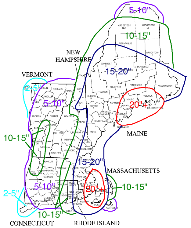
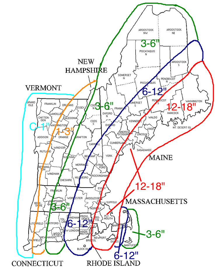
2 minutes ago, Chrisrotary12 said:
Here is the map that I ran with for my blog yesterday afternoon.
You are clearly not buying the big QPf numbers back into central New Hampshire and Western New England
-
6 minutes ago, CoastalWx said:
It's the mid levels, and that is thanks to the interaction of the nrn and srn stream s/w's.
I dunno, I'm definitely not confident in big numbers at this time. I see a few Scooter flags that keep me in check for now. Yeah yeah....I know about banding and some lucky weenies who may get into it, but a wide area of 12-18+?? Not there yet.
I agree. It seems really aggressive, but GYX has been aggressive for several days and they often aren’t
-
1 minute ago, CoastalWx said:
Sounds about right.
You probably know my agenda here....Wed am is the first leg of a 6 leg around the world trip, starting in London. If I miss it I'm screwed. Also hate to miss a good storm by leaving tonight. Considering driving to NYC and flying from there early Wed, or catching and early BOS-JFK flight connecting to London Wed morn since I'd think Logan would be open by 6am Wed.
In terms of weather itself, there is a consistent signal for 1" or more qpf all the way up here (now in Boscawen permanently) even with a track outside the benchmark. Is it the mid level track or is it the strength of the NS pulling back moisture up here sort of like an Inv Trough?
-
What do you all think of the time of peak conditions at BOS? I'm thinking heavy by Tues morn and peaking Tues afternoon? Then lighter snow but windy Tues eve?
-
WPC on board as of 5am for 12-18 across much of New England and 18+ for our easterly friends.
THE STORM IS FORECAST TO INTENSIFY RAPIDLY OFF THE
CAROLINA COAST AND THEN LIFT NORTHWARD. THE MID-ATLANTIC COASTAL
PLAIN WILL RECEIVE ONLY LIGHT SNOW ACCUMULATIONS...BUT NEW ENGLAND
IS EXPECTED TO BEAR THE FULL BRUNT OF THE DEVELOPING NOR'EASTER
BEGINNING MONDAY NIGHT AND PEAKING ON TUESDAY AND TUESDAY NIGHT.
THIS POWERFUL STORM WILL CREATE TREACHEROUS OUTDOOR CONDITIONS
WITH HEAVY SNOW AND STRONG WINDS. SNOWFALL OF A FOOT OR GREATER IS
EXPECTED OVER MUCH OF NEW ENGLAND...WITH AMOUNTS POSSIBLY OVER 18
INCHES FROM EASTERN MASSACHUSETTS INTO MAINE. PEOPLE IN THESE
AREAS SHOULD MONITOR LOCAL INFORMATION ON THIS POTENTIALLY
DANGEROUS WINTER STORM.
-
2 minutes ago, dendrite said:
I’d wait until the 00z runs before backpedaling. The euro wasn’t great, but don’t change everything over a few 18z runs. Maybe everything ticks back west at 00z with new raob data.
its not dropping our qpf dramatically. although I have to drive to the airport at 4am Wednesday so I really should hope we just get a few inches....
-
9 minutes ago, STILL N OF PIKE said:
Everyone loves a pounding
preach brutha
-
1 minute ago, Weatherexpert said:
Yet another low pressure system will form off the south and trek to the north east. An upper-level low pressure system moving in from the Great Lakes will give the entire area a prolonged period of light-moderate/ snow late Monday evening through Wednesday afternoon. The most amount of snow will fall Tuesday morning through late Tuesday evening... that's when it will get CRAZY. There will be an upslope effect across the Adirondacks, Catskills, Greens, and Berkshires
Still early to tell but i predict another snow pounding and I mean pounding. Please bring your pets indoors, keep your shovels on hand, and stay off the roads! Please stay safe everyone as this past storm has caused devastation in Waterville and a car skidded off the road into my yard causing severe grass damage. Stay safe everyone
I believe you have that.
-
 8
8
-
-
24 minutes ago, moneypitmike said:
Isn't it great racking up the frequent flyer miles for free trips you have no desire to go on because you just want to be home when the work trips are done?
Ahhh yes that happens sometimes. I hate to miss biggies though. Need a back up plan for this one I think. I once sacrificed 5K for a storm...Jan 96 in Philly. Worth every penny.
-
Just now, CoastalWx said:
If Logan has issues, I wold expect incoming delays and issues into Wed.
yeah thats a problem...its the start of a 10 day around the world trip and I work all day Thursday in London. Was hoping the int'l flights would get priority to land.
March 12/13/14 Blizzard/Winter Storm/WWA etc
in New England
Posted
Oh my, death band building back from maine into central nh. keep comin baby