.jpeg.334887ee505ee3a32ba3405431f39d37.jpeg)

Seminole
-
Posts
180 -
Joined
-
Last visited
Content Type
Profiles
Blogs
Forums
American Weather
Media Demo
Store
Gallery
Posts posted by Seminole
-
-
This will get some attention.
-
9 minutes ago, dizzy9479 said:
Josh is in Port St. Joe - his twitter shows heavy rain but almost no wind at all coming in.
A lot of wind on the east side we are probably steady 50+ now
-
House has been swaying off and on since 2:00 AM. Steady 25 to 30 mph wind now. Looks like the bad stuff is a couple of hours away. I will post some pics when we get some more daylight.
-
 4
4
-
-
30 minutes ago, NavarreDon said:
Another E shift on the guidance for the 18Z run. I’m out of it now, & will have to mow tomorrow….ugh!

.Going to take a right hook here at SGI
-
1
-
-
6 minutes ago, eyes2theskies said:
18z models trended way west
Which may explain why the last NHC disco hinted at the intensity forecast shifting a little higher.
-
12 minutes ago, Windspeed said:
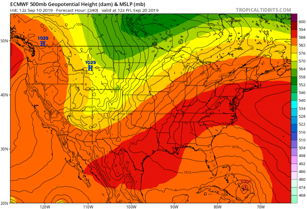
Please take these maps with a grain of salt. The rapid intensification of what would potentially be Grace off the SE coast is a result of a very dynamic and favorable upper environment that the GFS evolves around 200 hrs. Again, this is way too far out and therefore this may not pan out at all. But obviously that's some crazy ventilation on the backside of a TC that bends back to the NW late in the run. No wonder the GFS is bombing out the hurricane into landfall.

Hurricane David 1979 Hurricane David
-
14 minutes ago, Ed, snow and hurricane fan said:
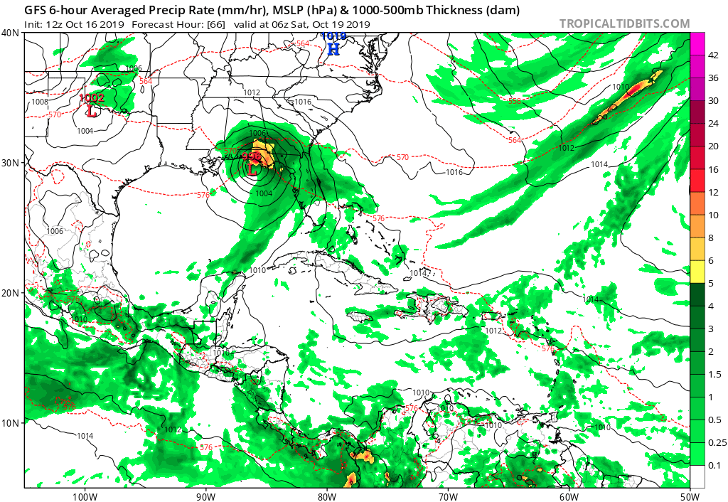
Tropics thread, Fred and GFS forecast Grace (95L, I think, hits S Carolina and drifts SW and meanders), 15 day total rain in excess of 20 inches parts of the Florida Panhandle.

I'm right in the bulls eye of that 20 inch rain total. I guess on the bright side I won't have to put water in the pool for awhile.
-
 2
2
-
-
13 minutes ago, cptcatz said:
The swirl is clearly evident just west of Inagua, problem is there's no convection for hundreds of miles.
Naked swirls are just so much fun to follow.

-

Look like COC is over or near Inagua.
-
2
-
-
The next 36 hours will have a lot of land interaction either directly over land or near it. Not exactly the best setup for a strong storm.
-
21 minutes ago, NavarreDon said:
Not the best with models but it looks like the 12Z GFS is initializing with Marco @ 1005. Will this cause issues with the whole run?
.Louisiana in the cross hairs for both Marco and Laura on that run.
-
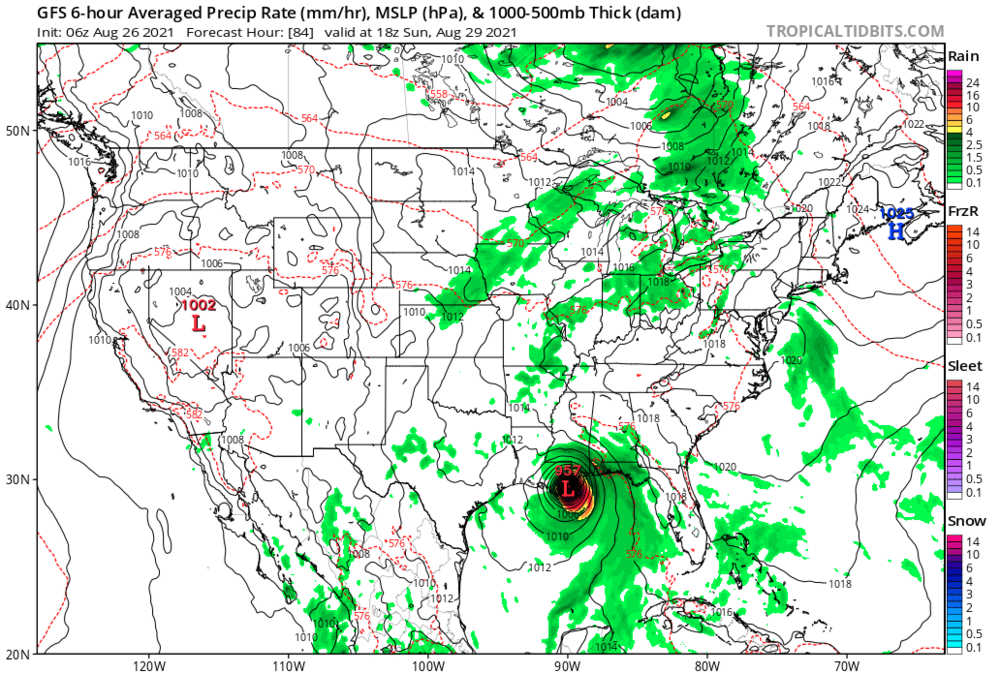
12Z GFS a little more bullish with the BOC system. Higher end TS off PC coast Saturday.

-
36 minutes ago, cptcatz said:
Is it me or does 95L look like it's getting better organized with every frame on satellite?
https://www.star.nesdis.noaa.gov/GOES/conus_band.php?sat=G16&band=GEOCOLOR&length=24
Sure seems that way.
-
12z Euro picking up on what the GFS has been hinting at albeit much weaker and slower.
-
If this hits as a high end CAT 4 Tallahassee will lose the entire power grid. 95% power outage and it will be weeks to a month for some to get it restored. I cannot overstate how poorly situated the power grid is relative to large trees that will bend better than Stormy Daniels
-
1
-
-
1 minute ago, NJwx85 said:
I wasn't comparing the impacts of Sandy to Florence. The comparison is because the larger wind field of lesser winds can often produce a higher category storm surge.
I agree and sorry for misunderstanding your earlier post. On the contrary a storm like Charley 2004 had little storm surge with it and it was a high end CAT 4.

Major Hurricane Ida
in Tropical Headquarters
Posted
Borderline CAT 5 around Port Arthur