.jpeg.334887ee505ee3a32ba3405431f39d37.jpeg)

Seminole
-
Posts
180 -
Joined
-
Last visited
Content Type
Profiles
Blogs
Forums
American Weather
Media Demo
Store
Gallery
Posts posted by Seminole
-
-
3 minutes ago, yoda said:
Looks like Big Bend of FL
I will have a front seat view.
-
6 minutes ago, Windspeed said:
One thing is for certain, whatever pattern evolves in place for the remainder of the Atantic hurricane season and Western Hemisphere, the ongoing La Nina is going to be one of the strongest well into the Winter months.
A 4th year in the row of La Nina? Has that ever happened?
-
3 minutes ago, Eskimo Joe said:

-
GFS is at least consistent with a Caribbean TCG. This run has it effecting Louisiana instead of scraping the Florida E coast.

-
This should grab some folks attention.

-
2 hours ago, GaWx said:
Based on my memory, these fruit based terms were originated 10+ years ago by board member and chaser, Josh Morgerman. And they stuck!
Those threads back then when he was on the chase was a perfect example how crowd sourcing info can pay dividends. Kind of nostalgic when you think about it.
-
 1
1
-
-
34 minutes ago, Normandy said:
The GFS basically stalling and retrograding multiple waves in the MDR is bizarre.
SAL is still significant enough to strangle out any potential TC in the MDR.
-
1
-
-
If the disintegration of the Bermuda High in the later GFS runs comes to fruition it likely means any CV spin ups will be fish storms.
-
1
-
 1
1
-
-
I think it is safe to agree that peak SAL is not going to happen until Mid August or even later given current conditions. Any TC formation would likely be in the GOM or Western Caribbean in the near term.
-
4 hours ago, Modfan2 said:
This; in my past 10 years in S FL I cannot remember a summer being this dry on the East Coast and water temps from the boat are running 82-84 and 86 in the Gulf Stream which is a little cool for this time of year.
Obviously things can and will change but Fl East coast cities are running 5-8” rain deficits in the middle of rainy season.
The past 2 weeks have been very dry around the coast of the big bend. We have storms build but don't drop rain until inland. The past 2 days have been a return to normal but like you this is our rainy season.
-
SAL is just brutal out there.
https://tropic.ssec.wisc.edu/real-time/sal/salmain.php?&prod=split&time=
-
3 hours ago, ldub23 said:
Euro a bit less enthusiastic on the wave. However JB says it "MAY" get hyperactive
"In close" will be hard to get unless the mega trof is replaced with the Wheel.
Meanwhile the East Pac is hyperactive with 3 lined up and more on the way. For a hyperactive atl that will also have to change.
WOW!!!!!!!!!! GFS showing the first wintertime low ripping across the eastern US. Earlier than even i thought

Meanwhile, even though the "experts" insist the tropics are primed to come alive the Euro is pathetic thru Aug22. Lets face it, anyone now saying the tropics are going to come alive are just repeating climo, nothing more. They sure as hell better come alive if there is going to be a season.

Finally at hour 384 we have 1 trof protective trof off the coast while yet another one is slamming east to replace it. 54 this aint. The whole US coast is snug as a bug in a rug with this pattern.
I take those long range forecasts with a grain of salt but those fronts sagging that far south this early in the season is not the norm.
-
1
-
 1
1
-
-
That is a ton of SAL in the Atlantic basin

-
A ton of SAL out there right now.
-
14 hours ago, GaWx said:
3rd year La Nina (including borderline cold neutral) ACE:
1874: 47
1894: 135
1910: 64
1917: 61
1956: 54
1975: 76
1985: 88
2000: 119
Quiet early years like 1874, 1910, and 1917 were very likely a good bit higher in reality. And with it being a very active era, I feel that the higher ACE 3rd year La Nina years like 1894 (135) and 2000 (119) are close to where I am as of now. One thing I remain pretty comfortable with is this highly likely not ending up being a hyperactive season. Third year La Nina seasons have pretty consistently not been as active as respective prior (2nd year La Nina) seasons. But another thing is that every one of these years had significant impact somewhere on the Gulf coast of FL. Thus, I highly doubt it will turn out to be quiet for the US as whole even if ACE ends up near or even below the longterm average. Consider how bad 1985 was on the US, for example. I'm not forecasting another 1985 level of US impact necessarily but am just saying that a lower ACE can be quite deceiving.
Very interesting regarding the Gulf Coast of FL. 1956 Flossy, 1975 Eloise, 1985 Kate and 2000 Gordon were all panhandle or nature coast storms. With the exception of Kate, all were September storms. Thanks for putting this together.
-
1
-
-
21 minutes ago, Ed, snow and hurricane fan said:
I remember the 1997 CSU forecast busting because of a poorly forecast warm ENSO. CSU has busted before, if one always predicts their numbers are too high, just law of averages, one will eventually be right.
Maybe CSU will bust, I don't know, but with an abnormally warm Gulf, with flow usually a general W to E from the Equinox on, I can see even an average season becoming quite memorable with a Florida major. 1985, Hurricane Kate weakened to Cat 2 from Cat 3 and hit Florida a week before Thanksgiving.
I was in Tallahassee for Kate then attending FSU. The amount of trees blown down was incredible. The only thing that made it not too bad was that it happened in November so living without AC for weeks was not too bad. And as for a city learning anything from Kate, that never happened. Tallahassee is still lined with many canopy roads with power lines right there amongst all those trees. Never lived in a city where power was so prone to go out because of tree limbs, squirrels you name it. The power grid I have on St. George Island is more stable than the Tallahassee power grid.
-
1
-
-
18 hours ago, Ed, snow and hurricane fan said:
Gulf coast of Florida indeed. Right now the STR is keeping anything that would form from reaching the Gulf, but late September and October, when the Westerlies are usually in the Western Gulf, I wouldn't expect the abnormally warm Gulf to have cooled much. Big storms immediate Tampa area are rare, but this seems like the type of year that could do it. But anywhere in the Eastern GOMEX will be at risk in October.
An issue with October is usually by then a couple of fall cold fronts typically make there way through North Florida and it does impact the SST's in the northern GOM. There are outlier years like 2018 which gave us Michael but those are rare. So far this season has been very similar to 2011, Southern Plains baking and the the S.E. East Coast stuck in a blocking pattern.
-
1
-
-
18 minutes ago, Ed, snow and hurricane fan said:
0Z Euro still sees a system in the Caribbean, and various ECENS are still liking either the op system or one a few days behind. Nothing obvious on the GFS. Re: 2011- one of two unpleasant years retired met Larry Cosgrove is using for this season. 2011 was the year the dry side of sheared TS Lee downed powerlines around E Texas, one of which started the month long Bastrop wildfire, which destroyed almost 2000 homes in a fairly rural county. Fires that year in the hills just W of Austin, which may be developed now due to the rapid growth of the city, and all around Possum Kingdom Lake. Add a few storms, but follow the pattern, there will be wailing and gnashing of teeth in the various East Coast forums about all the 'fish'.

2011 was the second warmest summer in U.S. history. Deep south and Southern Plains states cooked that year under dome after dome of high pressure. DFW had 56 days of triple digits.
-
1
-
-
This year is shaping up like the 2011 Season. La Nina with the US east coast dominated with blocking High pressure.
-
Looks like the 12Z GFS backed way off of the potential Caribbean genesis.
-
1
-
-
It is in one hell of sheared out environment.
-
20 hours ago, cptcatz said:
First time this season the bearish Euro has shown a solid TC in the Atlantic. Seems like over the past few years the Euro showing a TC is not something to brush off...
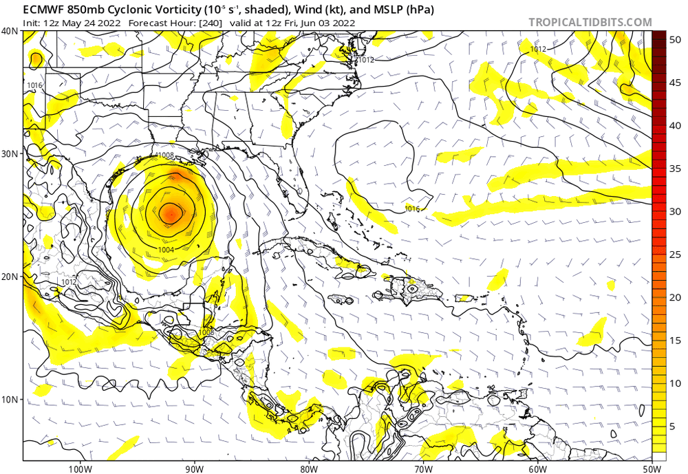
TS formation in the BOC in June happens more often than not.
-
1 hour ago, floridapirate said:
I'm calling the season over.
I think it's reasonable to put a fork in October. November may have a surprise ala Kate 1985. https://en.wikipedia.org/wiki/Hurricane_Kate_(1985)
-
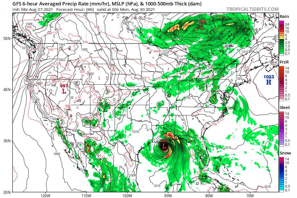
6Z GFS: Borderline CAT4

-
1
-
Hurricane Ian
in Tropical Headquarters
Posted
This is going to be what to watch for as far as direct impact is concerned.