Reb
-
Posts
738 -
Joined
-
Last visited
Content Type
Profiles
Blogs
Forums
American Weather
Media Demo
Store
Gallery
Everything posted by Reb
-
I always use zone area forecast personally. It’s probably computer generated too tho
- 782 replies
-
- 1
-

-
- extreme cold
- snow
- (and 1 more)
-
Yeah I had 2” in Seymour and there was 10” like a few miles from my house. Rough one.
- 782 replies
-
- 1
-
-
- extreme cold
- snow
- (and 1 more)
-
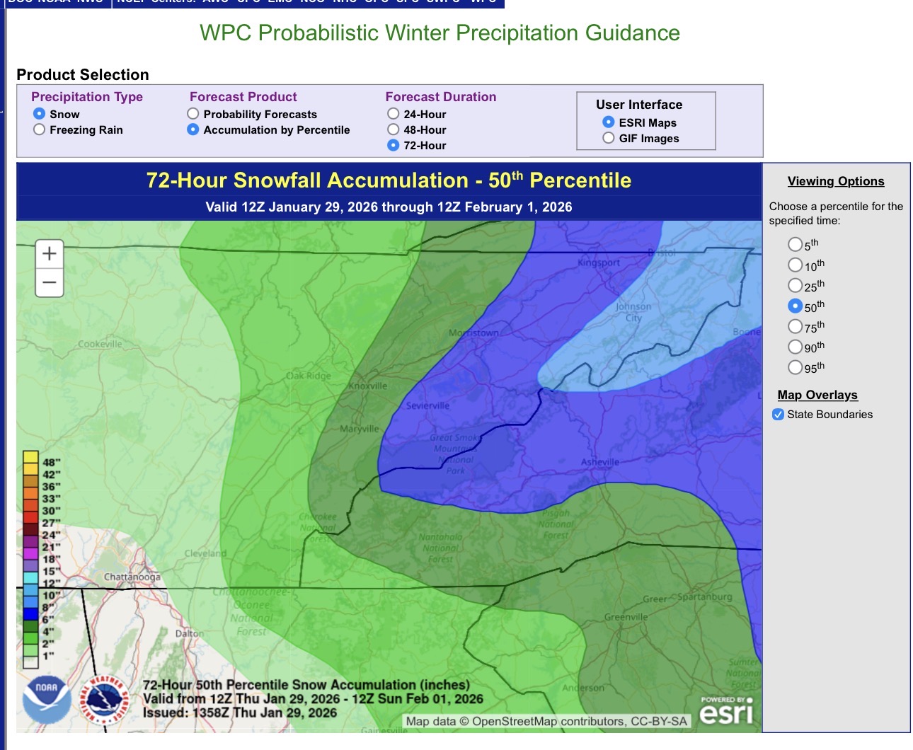
95th percentile shows greatest totals but only 5% chance
- 782 replies
-
- 1
-
-
- extreme cold
- snow
- (and 1 more)
-
12zAIFS bumped totals up from 06z
- 782 replies
-
- 2
-
-
- extreme cold
- snow
- (and 1 more)
-

- 782 replies
-
- 2
-
-
- extreme cold
- snow
- (and 1 more)
-
12z NAM starts the show at 1600 tomorrow in Knox. Most other models start around 1900 FWIW.
- 782 replies
-
- 2
-
-
- extreme cold
- snow
- (and 1 more)
-
This was my cartoons growing up
- 782 replies
-
- 4
-
-

-
- extreme cold
- snow
- (and 1 more)
-

- 782 replies
-
- 1
-
-
- extreme cold
- snow
- (and 1 more)
-
The RGEM did the best with this last storm IMO. Really hoping it scores a coup on this one as well.
- 782 replies
-
- 1
-
-
- extreme cold
- snow
- (and 1 more)
-
She’s a beaut, Clark
- 782 replies
-
- 1
-
-
- extreme cold
- snow
- (and 1 more)
-
This is for BAM wishcasting the last storm north. Feeling pretty confident here in Seymour

-
NAMMing has commenced
-
NAM is running. I’ve given up on weather next 18z
-
At this point we will have a NAMMing before the westhernext is out
-
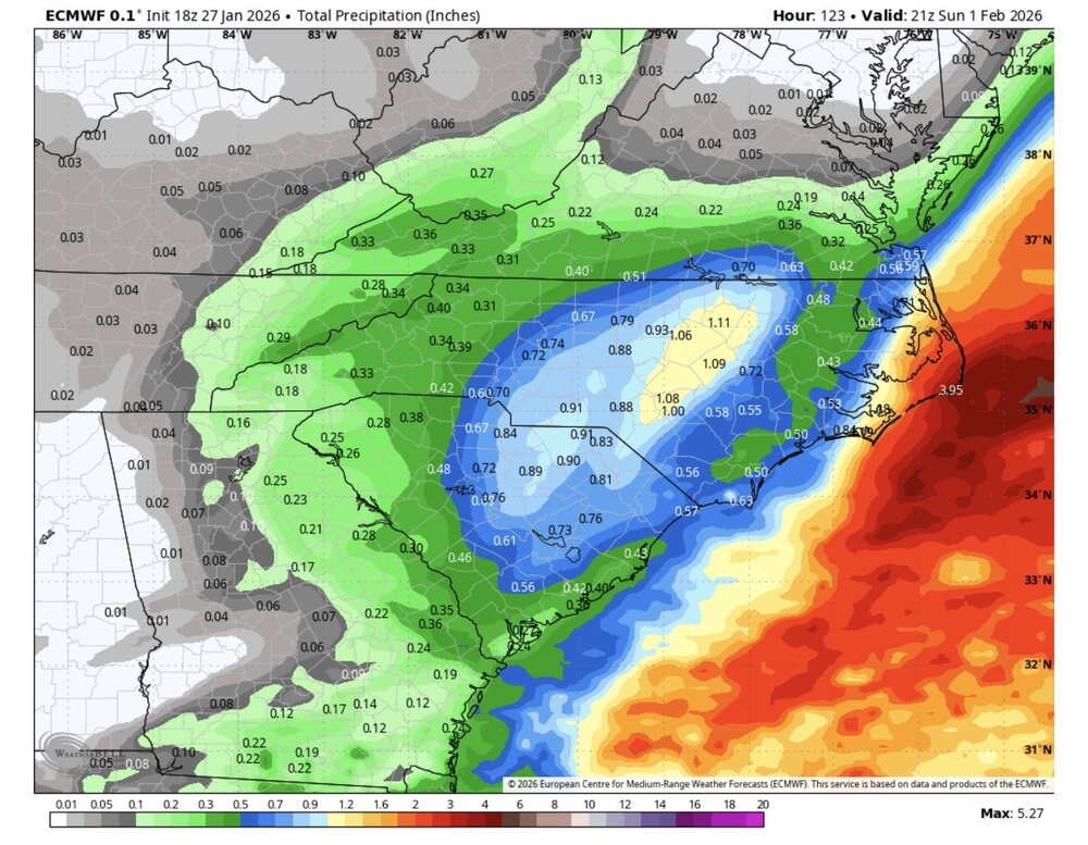
Stolen from the other board but guys here is that 2nd slug we were waiting on

-
OP caving as well
-

-
That’s exactly what we need to happen
-
If it pans out this will sneak up on a lot of people. Combine mets and the public being gun shy over what happened with the last storm…no one will buy into it.
-
This is some good stuff here!
-
I will say, this has a huge boom or bust potential. I’ll gladly swing at this one and potentially miss vs what he had with the ice etc
-
CMC looking good for ETN here we go again. Lol
-
Man if I had a dollar for every time I said that the past 2 weeks I’d be living high on the hog!
-
I’m just ready for spring
-
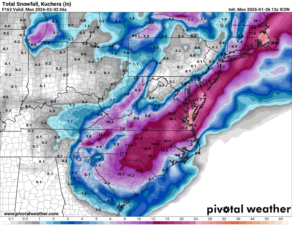
ICON nails the eastern valley