

Calderon
-
Posts
1,133 -
Joined
-
Last visited
Content Type
Profiles
Blogs
Forums
American Weather
Media Demo
Store
Gallery
Posts posted by Calderon
-
-
4 minutes ago, Drz1111 said:
I don't agree with that - that's an oversimplification when all these boundaries are interacting.
Okay, then what else would it be? Winds ahead of the warm from have been easterly, for well over 4 hours and now they've become southeast and DP and temp is rising more. I've kept a close eye on the Mesonet, and the warm front is spot on where I said it was last hour and has progressed a little farther north since.
Sometimes the simplest answer is actually the right one.
-
3 minutes ago, Drz1111 said:
I don't think that's right. Its more like an outflow boundary or something. Dew is at 64 in OKC.
No, it's correct. The warm front, per that image, was between OKC and Chickasha. An outflow boundary would NOT have an easterly wind component.
-
8 minutes ago, Eskimo Joe said:
OMG what a Class 1 kook. Wow.
Eh, the wording is funky with that. He does say what it could potentially be with radar and his own very long visual experience. That said, whoever said David Payne doesn't do that must forget about his days as a chaser for KFOR and he's said it a couple times at KWTV also.
They both need to knock that crap off.
-
Can we stop with the random, uncaptioned screencaps? This is going to be a busy enough day already
There’s also a separate threat specifically for today created.
.-
 1
1
-
-
Just now, Eskimo Joe said:
This is the danger of going high risk before the midday update on day 1. Really worried this busts now because everyone is expecting a big day and you'll look like a fool if this doesnt pan out. Ironically this flooding threat in Oklahoma is just as big but it's getting almost no coverage.
Exactly, and because of this, I hope for their sake is does verify to soem capacity because the SPC has had some pretty good busts lately and I think folks may be disregarding them to a degree.
-
2
-
-
2 minutes ago, Disc said:
High risk expanded to include the OKC metro area. The discussion with this new update is scary.
A serious outbreak of destructive, tornadic supercells is likely
   over parts of this region this afternoon into evening, especially in
   the high- and moderate-risk areas.  Given the expected fast storm
   motions, especially mid-afternoon into evening, a few of the
   best-organized supercells may reach an equilibrium with their
   already very favorable mesoscale environments long enough to sustain
   wide, long-track tornadoes.
Yeesh, some of the strongest wording I've seen since 4/27/2011.
The ceiling is incredibly high for this event.
-
If it’s still on the ground, it’s about to go right through Kinsley. I’ve been through that town before and while it’s not big, it’ll be lucky if it’s missed.
. -
These guys got a large TOG
Another station carrying Val and Amy Castor chasing. They’ve been on the cell winced it first produced near Beaver, OK.
. -
Large tornado just south of DDC, looks to pass a couple miles east of the city, thankfully.
-
Today couldn't have really been more raw of a day. At least STL set a new record low maximum for the date of 50, the old one was 53. So, that's something...I guess?
-
Levee has been overtopped near Winfield, MO in Lincoln County, with a FFW in effect. The MS River will continue to rise until overnight Saturday into Sunday.
-
TOG in Stephens Co., OK near Loco continues to slowly move NE.
Storm mode is getting messy with so many cells going up in this uncapped environment.
-
The circulation is going to pass just west of, if not right over, Fort Worth Alliance Airport (KAFW), which is a big FedEx hub for the southern Plains.
New TOR warning for NW Tarrant, extreme SE Wise, and SW Denton Counties. General direction is right at Denton over the next hour.
-
Pretty decent rotation in eastern Parker Co., NW of FTW, passing over I-20 near Aledo now. Nothing confirmed at the moment.
-
1
-
-
TOR warning south of Lawton, OK.
-
Side note, these comms issues with the NWS pages are really bad timing right now.
-
1
-
-
The circulation is strong but pretty broad, looks more like the RFD undercut it and there is some interference with cells merging in from the south.
Thankfully that area is pretty rural and mostly open farmland with only widely scattered homes.
-
Just now, Araqiel said:
On the Lenapah rotation warning:
* At 304 PM CDT, a severe thunderstorm with strong low level rotation
that could produce a tornado at any time was located 5 miles
northeast of Lenapah, moving northeast at 30 mph.
Unusual wording?
I've seen wording like that used from multiple offices, notably OUN and HUN.
-
TOR warning for Madison Co., IL, near Edwardsville and moving NE away from the city and the SIUE campus.
-
TOR warning just NE of St. Louis, potentially near Edwardsville, IL.
-
I am watching the line of convection that is currently in central MO that likely will lay down a boundary that could potentially enhance the tornado risk in the STL metro, and that is something the NWS office here is also monitoring.
We’ve had some sun break through the cirrus deck and temps are responding rapidly now that the warm front has retreated north.
. -
Strong midlevel rotation on TOR warned cell moving into southern York Co., but no CC drop to conclude it's on the ground at the moment.
-
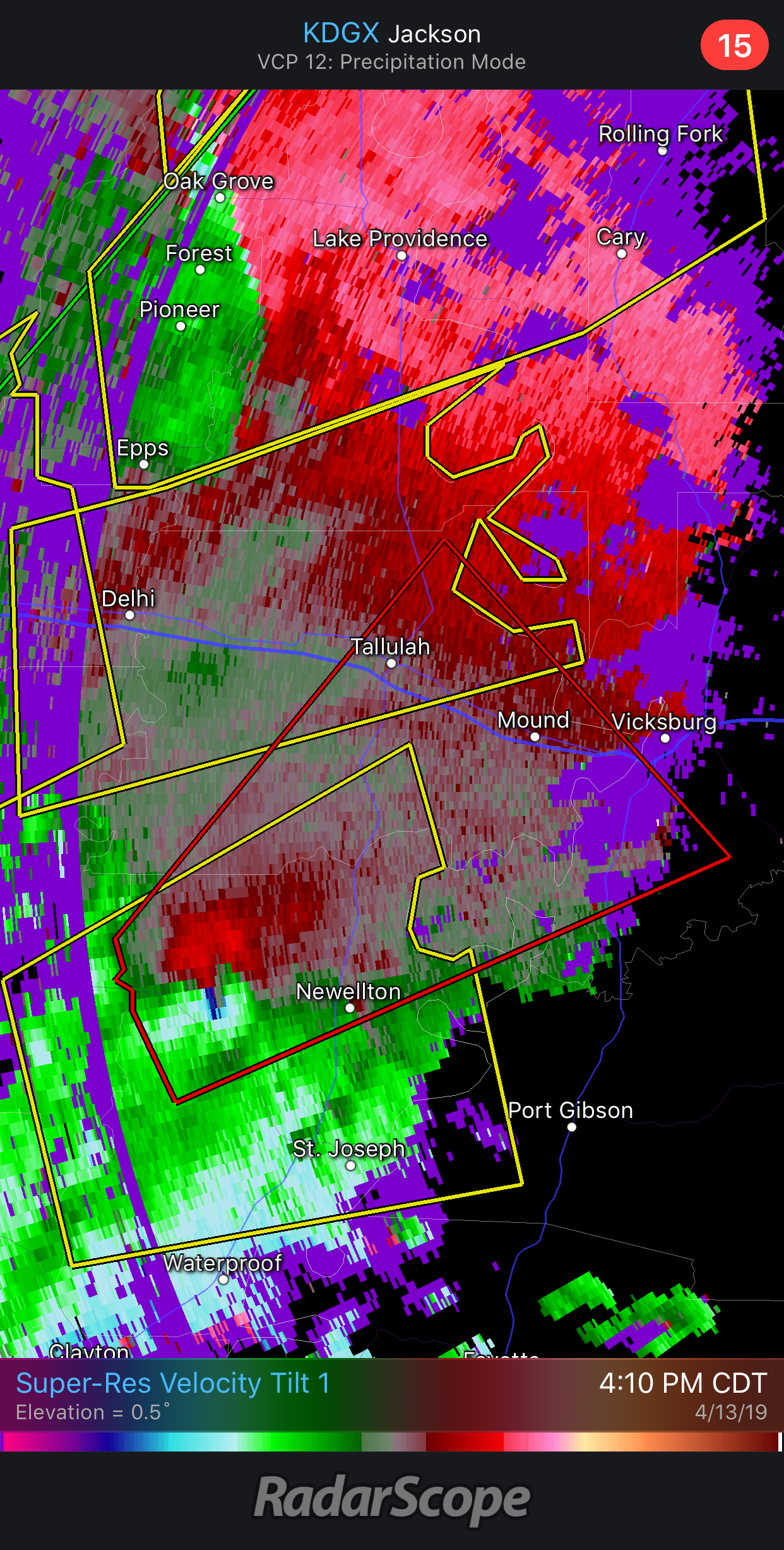
Storm mode still sucks, but that cell heading towards Vicksburg looks like it’s producing an absolute monster. Going to need a tornado emergency ASAP.

Eh, not necessarily because that area is incredibly rural farmland and swamps. There is literally almost nothing but a few crossroads “towns.”
. -
RFD undercut the Alexandria cell quickly, but that could change just as fast.
MAY 20, 2019 High Risk
in Central/Western States
Posted
Without a doubt. It's been hauling ass all morning at nearly 33mph averaged out.