.jpg.2573028626d558966424be2bdf9b8490.jpg)

Buckethead
-
Posts
2,180 -
Joined
-
Last visited
Content Type
Profiles
Blogs
Forums
American Weather
Media Demo
Store
Gallery
Posts posted by Buckethead
-
-
A long way out, but that 12z GFS...woof...
-
7 minutes ago, Queencitywx said:
GFS has something for 2/20

-
65° and sunny up here in Wolf today. Wow. Back to reality tomorrow
-
I had posted the same thing a little while ago but wasn't sure that it wasn't blowoff from the resort this morning, so O deleted it. It's picked up a little and the wind direction is wrong so I'm guessing it's natural snow.
-
10.6/5 and flurries this morning. Again.
-
10° and flurries this morning. Wasn't expecting that.
-
23 minutes ago, wncsnow said:
You know... For this to be such a "arctic blast" it is really not that cold at all. 40 here and pretty nice out really even here in Virginia. SE Ridge FTW!
It's currently 11° here. It's cold but it's nothing like last January's cold. We hit -9° a few times.
-
 1
1
-
-
Currently at 4400' in Wolf 11.4°/7 with a 25 mph wind and light snow.
-
5 minutes ago, MotoWeatherman said:
Still getting random flakes on Beech. Temp down to 9.7. Brrrrr
I've seen a couple of flakes here and there...thought it might just be the ski resort making snow and a little blowing over here but they aren't making any. Down to 6.3°/-4. Definitely a three dog night.
-
1
-
-
Ended up with 2.75". Not bad, and it puts me over 40" on the season...but I want bigger.
-
2
-
-
Im wondering how much nwf we'll get out of this. GSP doesn't seem to think there will be much at all.
-
1
-
-
42 minutes ago, NavarreDon said:
Looks like its snowing pretty good @ the Wolf via the cam.
Yes, it is snowing pretty good up here. 2" on the ground so far. 26.2/26
-
4
-
-
2 minutes ago, Met1985 said:
Just waiting to see it start here.
We've had flurries but that's it so far.
-
1
-
-
Snow has started to fall in Wolf, 32.9/27
-
1
-
-
It's a balmy 37° up here this afternoon. Time for shorts and flip flops!
-
1
-
-
Watches beginning to go up now.
-
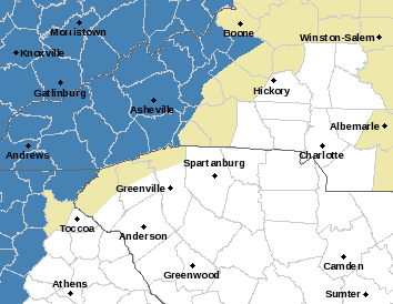
GSP seems optimistic for us on the border.
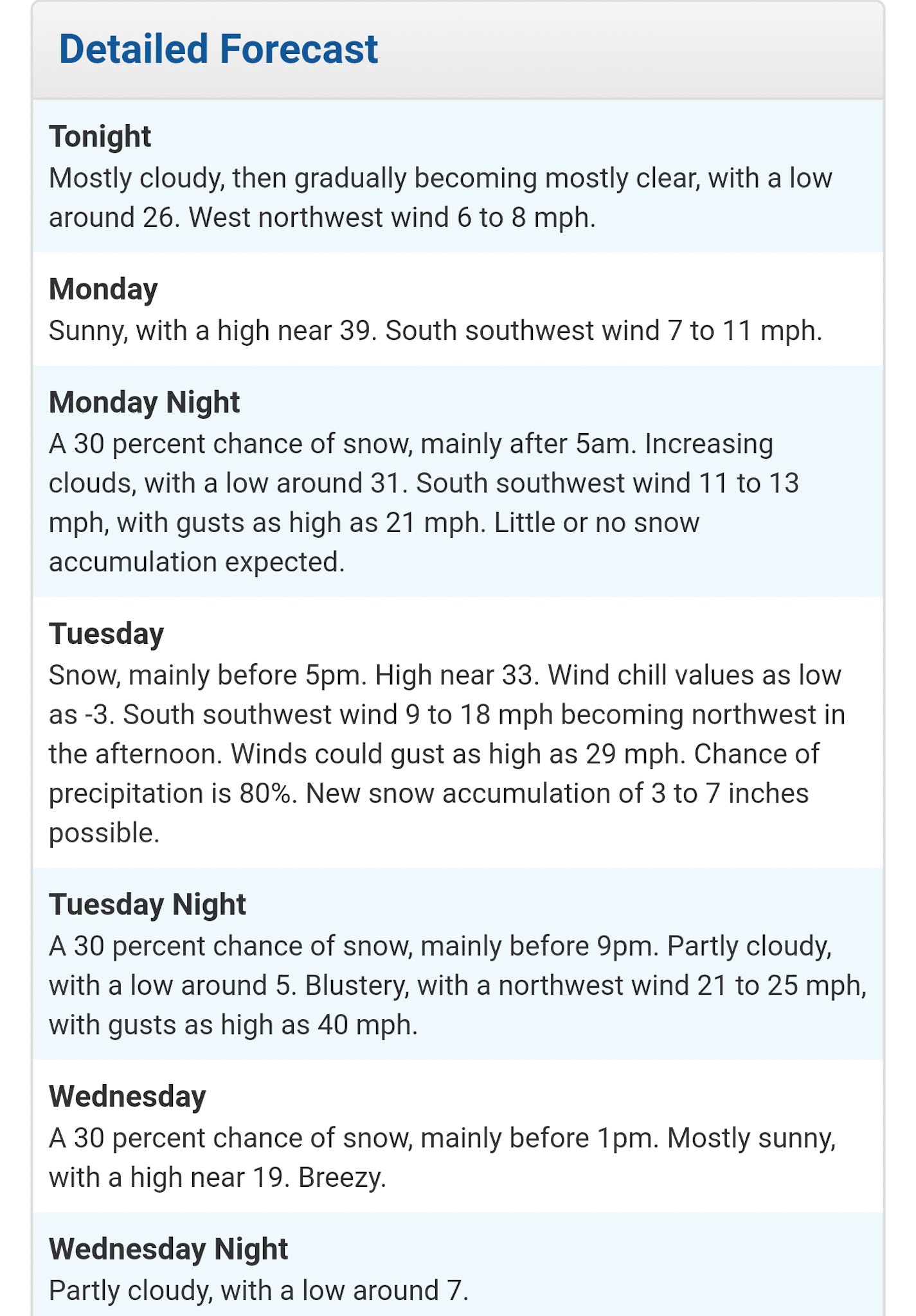
URGENT - WINTER WEATHER MESSAGE
National Weather Service Greenville-Spartanburg SC
255 PM EST Sun Jan 27 2019

...ARCTIC FRONT LIKELY TO BRING SNOW TO THE SOUTHERN APPALACHIANS...

GAZ010-NCZ033-048>053-058-059-062>065-501-503-505-507-509-280930-
/O.NEW.KGSP.WS.A.0002.190129T0600Z-190130T0000Z/
Rabun-Avery-Madison-Yancey-Mitchell-Swain-Haywood-Buncombe-Graham-
Northern Jackson-Macon-Southern Jackson-Transylvania-Henderson-
Caldwell Mountains-Burke Mountains-McDowell Mountains-
Rutherford Mountains-Polk Mountains-
Including the cities of Clayton, Pine Mountain, Mountain City,
Ingalls, Banner Elk, Newland, Faust, Mars Hill, Marshall, Walnut,
Allenstand, Hot Springs, Luck, Swiss, Burnsville, Celo,
Micaville, Ramseytown, Busick, Spruce Pine, Poplar, Alarka,
Almond, Bryson City, Luada, Wesser, Waynesville, Waterville,
Canton, Cruso, Cove Creek, Asheville, Robbinsville, Stecoah,
Cullowhee, Tuckasegee, Sylva, Franklin, Rainbow Springs, Kyle,
Highlands, Wolf Mountain, Cashiers, Brevard, Cedar Mountain,
Little River, Hendersonville, Fletcher, Dana, East Flat Rock,
Tuxedo, Etowah, Jonas Ridge, Ashford, Woodlawn, Old Fort,
and Saluda
255 PM EST Sun Jan 27 2019

...WINTER STORM WATCH IN EFFECT FROM LATE MONDAY NIGHT THROUGH
TUESDAY EVENING...

* WHAT...Heavy snow possible. Ridgetops of the Smokies and Balsams
  may see 4 to 6 inches of snow, with slightly higher amounts on
  the highest ridges. The Black Mountains and other ranges in
  northwest North Carolina may see 3 to 5 inches. The valleys and
  lower ridges across the mountain region will see amounts of
  less than 2 inches.

* WHERE...Portions of far northeast Georgia and mountainous western
  North Carolina.

* WHEN...From late Monday night through Tuesday evening.
-
3
-
-
33 minutes ago, burrel2 said:
Nobody in the Southeast is ever a lock for frontal passage snow. lol
Well, not nobody lol...
-
1
-
-
Just walked out the door to 14° and light snow. Caught me by surprise!
-
2
-
-
Is this thread for real? Jumping the gun a little aren't we?
-
1
-
 1
1
-
 1
1
-
-
1 minute ago, MotoWeatherman said:
Still snowing pretty good with nothing on radar. About 1.5 inches so far. Temp is 23.5. Overperforming for sure.
Are you up here full time now?
-
Around an inch on the ground now and still falling pretty good at 4400'...28/27
-
1
-
-
I was sitting at 39 at 7am. Now down to 30.4/29 and snow starting to cover the ground.
-
2
-
-
1 hour ago, Met1985 said:
What radar do yall use currently. I was using intellicast.com but since they went to wunderground there radar map has not been up to date.
I use pyk3l on Android. It's a $10 app though.


Mid to Long Term Discussion 2019
in Southeastern States
Posted
Much like Gamecock fans, I think most people in here are already saying "wait until next year."
I like where I'm sitting for next week.