

pondo1000
-
Posts
1,727 -
Joined
-
Last visited
Content Type
Profiles
Blogs
Forums
American Weather
Media Demo
Store
Gallery
Posts posted by pondo1000
-
-
10 minutes ago, buckeye said:
It's all relative and perception....and of course personal preference. But you kind of make my first point by asking if we've even hit normal snowfall yet when we are currently about 30% above normal.
Our climo is such that typically we nickle and dime our way to normal with light snowfalls that disappear in a few days....every once in awhile we get a true snowstorm thrown in there.
What are CMH's chances of not only having a white Christmas, but having accumulating snow on Xmas Eve and day? What are our chances of having a solid snow cover with intermittent refresher for more than 2 weeks? Those two things happen rarely but even more rarely in the same winter. The winter storm sucked if you're a snow stat lover, but it was still a disruptive winter storm that was fun to track and gave us a bulletproof snow cover.
I think we romanticize and exaggerate past winters....I know I'm guilty of that. I think its because we tend to lump events and memorable times together instead of looking at them for what they were, isolated events often spread out by years.
All that being said winter 77-78 was the benchmark A+ winter in my lifetime for many different reasons not just the blizzard.
I could probably be arm twisted into dropping to a B+ if we don't see another flake, but for now I'll stick by my A-. (I don't want to insult the weather Gods
 ) . I suspect with your standards we may all be dead before a Dilly-B rated or above winter happens again
 ")
The Christmas snow was special b/c it actually happened on xmas eve/day. That may never happen again in our lifetime (unless you are in your 20s). If it wasn’t for that boring stretch in all of January, this winter probably was an A in my book. So I’ll go with a solid B.
You know me, always reminiscing of yesteryear & my days on the east coast where we got real snowstorms. They did quite well again, Philly north to NY, this year. Around here, if we don’t score a true clipper train for a time in winter, generally it’s not a great winter & we get stuck praying we don’t get the WTOD with storms.
-
 1
1
-
-
8 minutes ago, Frog Town said:
Weren't the indices all torching in Late January, for February prior to this cold and snow outbreak?? I remember every outlook for February as above to much above normal. We'll see I guess.
Hah, yeah, ask The Weather Channel!
-
24 minutes ago, dilly84 said:
NAM looks like it'd be a good snow, but for some reason doesn't translate to accumulations
Unlike the last one, there should actually be decent ratios & no sleet!!!
-
 4
4
-
-
17 minutes ago, buckeye said:
It's funny we all called it a NW trend with the last storm, but it was more like a NW pop. It literally unfolded during the storm. I said I'd take my chances any day with a storm that rode from AL to central WV and east....but it got to WV and nudged into eastern OH, bringing the wtod with it. It really sucks when you can't trust models 24 hrs out.
We rarely benefit from NW trends but the most infamous one that we did was PD03. After the first wave came through the second bigger wave was supposed to be a miss south. I checked I remember checking the.18z models that Saturday evening and everything had suddenly shifted central OH into the game and that was less than 24 hours out.
So you’re saying there’s a chance? LOL
-
1
-
-
Just now, Frog Town said:
I don't know if I'm missing something, but accuweather seems to be thinking this next system is gonna be pretty substantial for a lot of us. I even checked to see if I was looking at an outdated map.
Saw the same thing. That forecast needs to be updated.
-
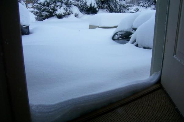
I yearn for another clipper train that can lay down snow cover like this (2010). Maybe next winter. This pic is out my back door that has 2 steps down to ground level. The snow was up past both steps to the door!
-
1
-
-
3 minutes ago, jbcmh81 said:
Not really. While it was the furthest NW and warmest, even it wasn't nearly warm enough and still showed far more snow for many areas.
Versus the other models it kept it much further NW so it was sniffing out something. Was it 100% accurate? No. But it kept a fly in the ointment the whole time.
-
3 minutes ago, vespasian70 said:
Another heartbreaker here. A sleet/frz/sn slop fest. Picked up 3" of junk.
Will ride the NAM with this next one.
NAM definitely scored a coupe with this one!
-
2 minutes ago, Gino27 said:
Don’t even wanna think about it lol. We overperformed on QPF so might’ve been double digits. I lucked out and got snow/sleet total of 5”
We got about 4” of sleet/snow
-
Snow globe right now. If only we avoided sleet yesterday, what could have been....
-
1 minute ago, Gino27 said:
99% sure I’m the luckiest guy on the planet right now. Sorry guys!
Ok so maybe 15 miles from you but still!!!! Grrr! Enjoy!
-
1 minute ago, JayPSU said:
Yep. If I’m reading the radar correctly, it looks like we’ll be dry slotted once we change back to snow. Those a little west of us...they could pickup a quick 2-4”.
I wouldn’t be surprised if I go from sleet to nothing.
-
Just now, dilly84 said:
Even west haven't done well unless far west
Yeah, I know, but crazy that Akron had sleet
-
Just now, Gino27 said:
Mostly snowing now. Wow
Christ, I’m in Powell so like 10 miles from you & still sleeting!
-
1 minute ago, dilly84 said:
Heavy sleet here with the flood returns.
Doesn’t matter I guess if you are north with this one. Need to be west.
-
2 minutes ago, Gino27 said:
I do think we might switch back to snow at least for a little. Running out of room though.
Heaviest sleet I’ve ever seen.
-
Still heavy sleet here.
-
Just now, JayPSU said:
Getting some wind whipped sleet banging into the windows.
Same here!!! Yet Cincy snow?! I give up
-
2 minutes ago, OhioWX said:
False hope. Sleet's coming down heavy in Mason again.
Ahh, dam
-
6 minutes ago, A-L-E-K said:

Wow!!!!!
-
Just now, buckeye said:
One thing for certain, our snow pack is bullet proof...
Should b fun to shovel!
-
4 minutes ago, HighTechEE said:
The 8pm obs all Cincy stations is finally back to snow, but most of the Dayton area still sleet.
Heavier returns especially south of Cincy. Fingers crossed for all of us it’s snow versus sleet. Painful especially when radar shows snow.
-
Just now, jbcmh81 said:
At this point, no one should bother until it starts snowing.
Hah, so true!
-
9 minutes ago, buckeye said:
I'm not throwing the white flag til morning on this one. I think the bigger bust threat on Thursday is weak/sheared vs. another sleeter
Hmmm, that scenario sounds familiar! LOL

“Let’s Talk Winter!
in Lakes/Ohio Valley
Posted
Indeed. Have a great Spring & Summer! Talk to you in the Fall.