1bert1
-
Posts
107 -
Joined
-
Last visited
About 1bert1

- Birthday 10/04/1969
-
January 30th- Feb 1st ULL and coastal storm obs
1bert1 replied to JoshM's topic in Southeastern States
Just started here ~20 miles north of Augusta, GA. Radar is really filling in. -
Southern Crippler - Get well soon Jimbo Storm Obs
1bert1 replied to BooneWX's topic in Southeastern States
I am staying up as well. Been up 24 hours at least but the wedge is stubborn and more precip is headed this way. It is 24 degrees here with ZR and a little ip. -
Yeah, I am one county to the south of the ice storm warnings and Helene with 100+ mph wind gusts ravaged my area. I hate the idea that some people that faced Helene will have to deal with this 1.5 years later.
-
GSP has issue ice storm warning for large area. https://www.weather.gov/gsp/
-
I remember Lookout from when this forum was eastern weather. Time flies!
-
It appears per radar that Augusta might be about to get hit hard with something! Yeah, I am 20 miles north of Augusta and it is finally changing over to snow.
-
Good breakdown...
-

-
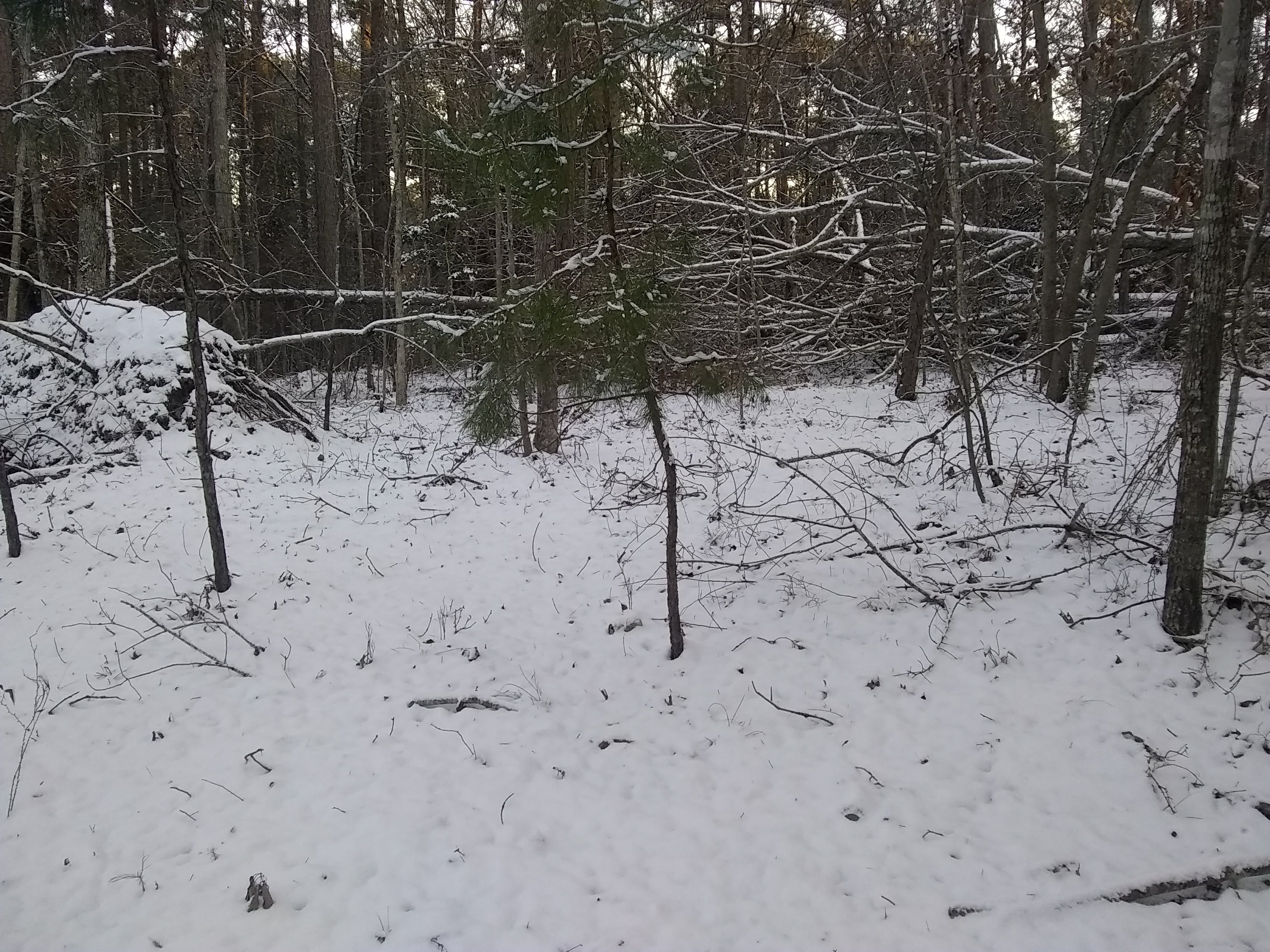
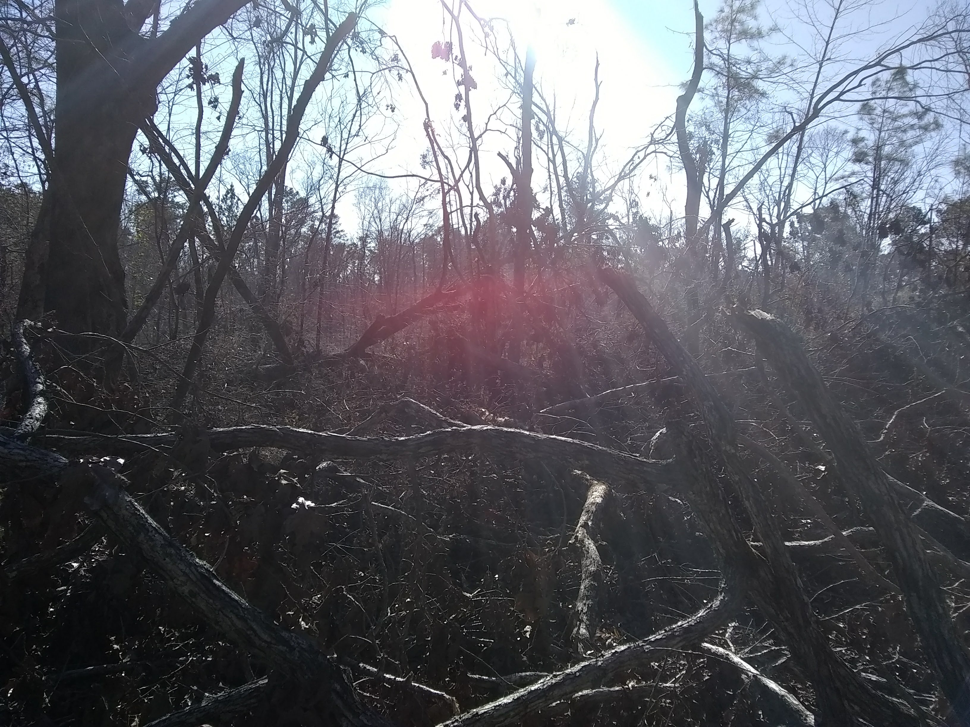
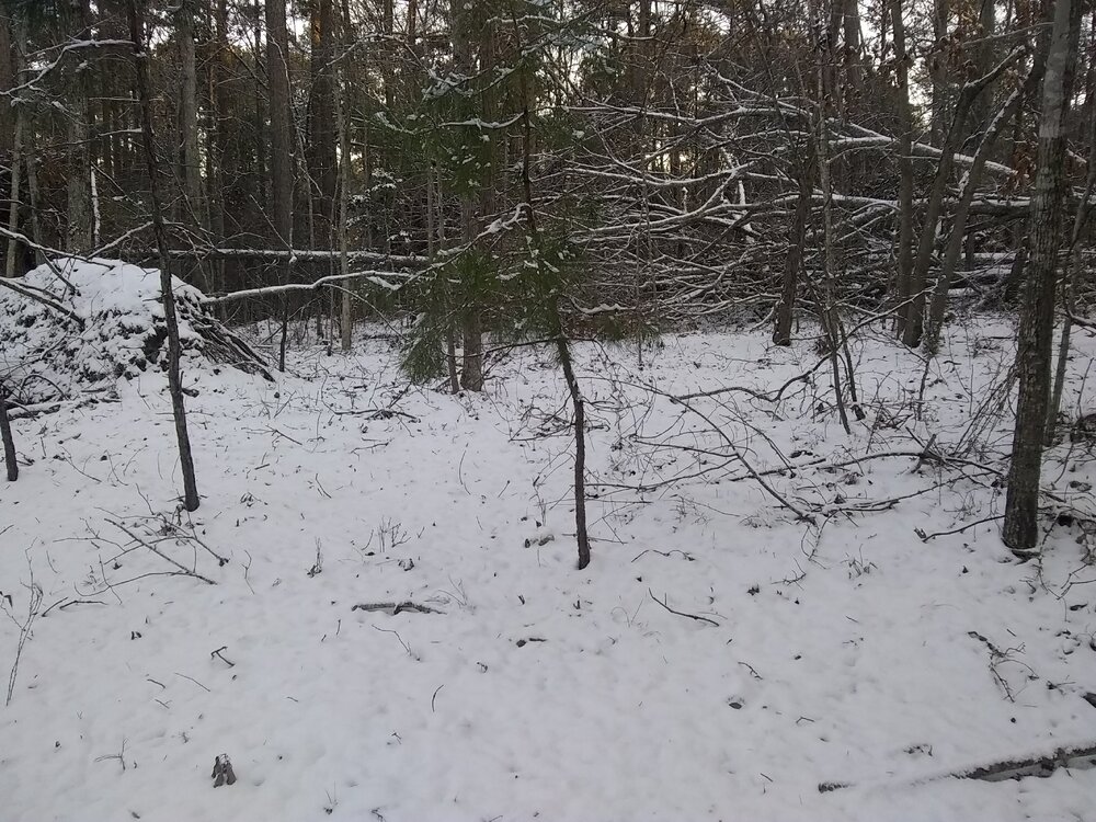
I don't see any snow total posts from Augusta, GA. I am 20 miles north of Augusta and ended up with 2 inches. I tried to find a place to take a picture with no trees down but thanks to being in the eastern eyewall of Helene, I have extensive damage to trees all over my land due to 100+ mph wind gusts.
-
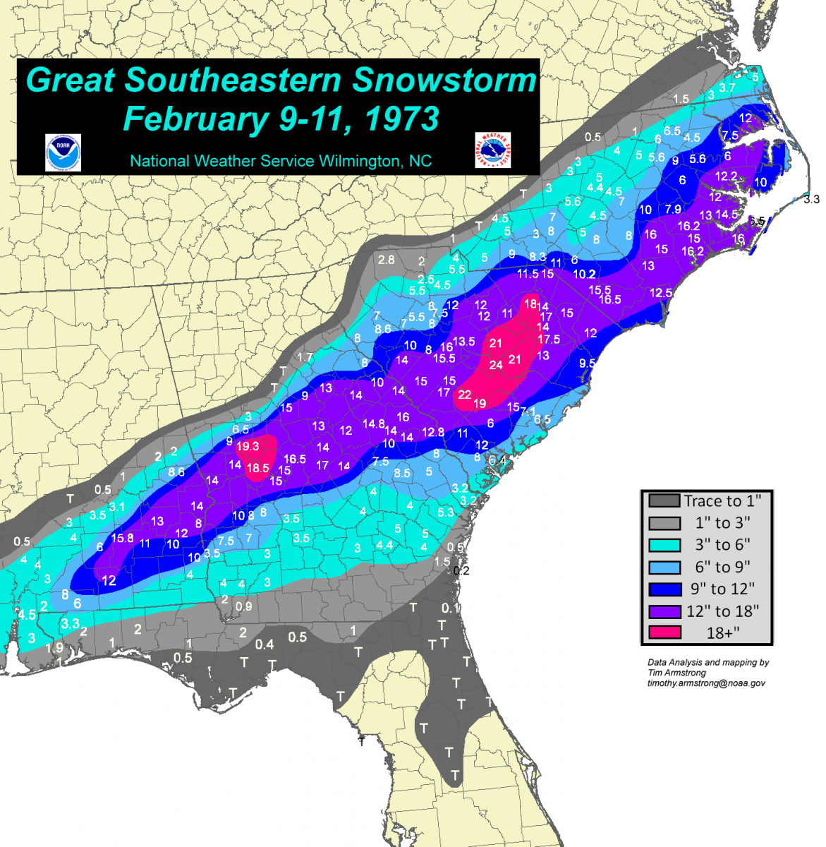
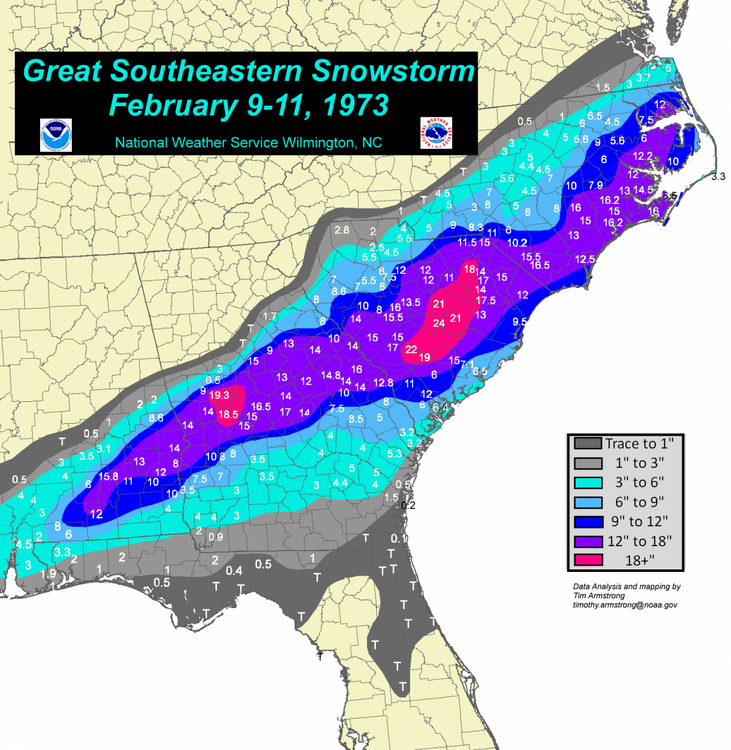
Here is the accumulation map from 73.
-
It just started snowing here.
-
The FFC in GA has issued a Winter Storm Watch. Forsyth-Hall-Banks-Jackson-Madison-Paulding-Cobb-North Fulton- Gwinnett-Barrow-Clarke-Oconee-Oglethorpe-Wilkes-Carroll-Douglas- South Fulton-DeKalb-Rockdale-Walton-Newton-Morgan-Greene- Taliaferro-Heard-Coweta-Fayette-Clayton-Spalding-Henry-Butts- Jasper-Putnam-Hancock-Warren-Troup-Meriwether-Pike-Upson-Lamar- Monroe-Jones-Baldwin-Washington-Glascock-Jefferson-Harris-Talbot- Taylor-Crawford-Bibb-Twiggs-Wilkinson-Johnson-Emanuel-Muscogee- Chattahoochee-Marion-Schley-Macon-Peach-Houston-Bleckley-Laurens- Treutlen-Stewart-Webster-Sumter-Dooly-Crisp-Pulaski-Wilcox-Dodge- Telfair-Wheeler-Montgomery-Toombs- Including the cities of Soperton, Franklin, Hawkinsville, Columbus, Decatur, Covington, Montezuma, Marietta, Atlanta, Sparta, Vidalia, Gray, Homer, Monticello, Warrenton, Eatonton, Ellaville, Talbotton, Toomsboro, Winder, Sandersville, Cumming, Dublin, Vienna, Alamo, Griffin, Pine Mountain, Greensboro, GIbson, West Point, Swainsboro, Mcrae, Eastman, Wrightsville, Athens, Madison, Jackson, Louisville, Newnan, Lawrenceville, Fort Moore, Fort Valley, Buena Vista, Watkinsville, Monroe, Crawfordville, Mount Vernon, Preston, Zebulon, Washington, Comer, East Point, Cochran, Dallas, Gainesville, Jeffersonville, Stockbridge, Cordele, Milledgeville, Abbeville, Macon, Forsyth, Douglasville, Lumpkin, Barnesville, Manchester, Americus, Riverdale, Warner Robins, Crawford, Peachtree City, Commerce, Conyers, Carrollton, Butler, Thomaston, and Roberts 330 AM EST Sun Jan 19 2025 ...WINTER STORM WATCH IN EFFECT FROM TUESDAY MORNING THROUGH WEDNESDAY MORNING... * WHAT...Periods of snow that could be moderate to heavy at times. Total snow accumulations between 1 and 3 inches possible. Light sleet and freezing rain will be possible in portions of east central Georgia late Tuesday night. Ice accumulations less then 0.1 inch possible. * WHERE...Portions of central, east central, north central, northeast, northwest, southeast, and west central Georgia. * WHEN...From Tuesday morning through Wednesday morning. * IMPACTS...Plan on slippery road conditions. The hazardous conditions could impact the Tuesday evening and Wednesday morning commutes.
-
When I lived on Beech Mountain back in 2010-2012 we had snow ratios of 40 to 1 to 60 to 1 in some very cold NWFS events. The temp was below 20 degrees to about 5 degrees during these events. The winter of 2010-2011 Beech Mt got 160 plus inches of snow.
-
Getting big flakes. I haven't seen snow here since 2021. Nice.
-
It sleeted here for 2 hours. Then it stopped and now it is starting to snow, no sleet. I am under heavier returns now. I think there must be a higher dry layer that is getting saturated. I am 25 miles north of Augusta, GA.