

TalcottWx
-
Posts
28,808 -
Joined
Content Type
Profiles
Blogs
Forums
American Weather
Media Demo
Store
Gallery
Everything posted by TalcottWx
-

The last hurrah? Putting all the eggs in the Tuesday 3/14 basket
TalcottWx replied to Ginx snewx's topic in New England
Modeling very clearly showed snow possible interior before warm air floods in this evening. -
The last hurrah? Putting all the eggs in the Tuesday 3/14 basket
TalcottWx replied to Ginx snewx's topic in New England
Simsbury is not the worst snow spot in interior Sne I can name about 15 towns around me that are worse. I know you get confused and tired this time of day take a nap -
The last hurrah? Putting all the eggs in the Tuesday 3/14 basket
TalcottWx replied to Ginx snewx's topic in New England
He doesn't look, he told me there were no red flags 48 hours ago and now there is a nipple on top of tolland -
The last hurrah? Putting all the eggs in the Tuesday 3/14 basket
TalcottWx replied to Ginx snewx's topic in New England
It's possible, but just not a comfortable experience. -
The last hurrah? Putting all the eggs in the Tuesday 3/14 basket
TalcottWx replied to Ginx snewx's topic in New England
The low sits over your house. In what world that is encouraging I don't know. -
The last hurrah? Putting all the eggs in the Tuesday 3/14 basket
TalcottWx replied to Ginx snewx's topic in New England
I'm moving back east. -
The last hurrah? Putting all the eggs in the Tuesday 3/14 basket
TalcottWx replied to Ginx snewx's topic in New England
Do you have the wrong decade pulled up on ur model site -
The last hurrah? Putting all the eggs in the Tuesday 3/14 basket
TalcottWx replied to Ginx snewx's topic in New England
I'll be pissed if that happens. Complete disaster of a model run for Connecticut. Thanks for nothing -
The last hurrah? Putting all the eggs in the Tuesday 3/14 basket
TalcottWx replied to Ginx snewx's topic in New England
Please euro. Bury us all. -
The last hurrah? Putting all the eggs in the Tuesday 3/14 basket
TalcottWx replied to Ginx snewx's topic in New England
Href qpf gone wild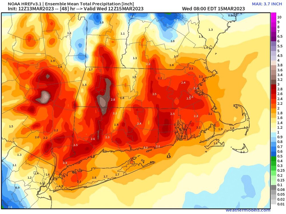
-
The last hurrah? Putting all the eggs in the Tuesday 3/14 basket
TalcottWx replied to Ginx snewx's topic in New England
We toss. Tupac dead -
The last hurrah? Putting all the eggs in the Tuesday 3/14 basket
TalcottWx replied to Ginx snewx's topic in New England
Weenie curved left -
The last hurrah? Putting all the eggs in the Tuesday 3/14 basket
TalcottWx replied to Ginx snewx's topic in New England
The rap is a terrible model -
The last hurrah? Putting all the eggs in the Tuesday 3/14 basket
TalcottWx replied to Ginx snewx's topic in New England
Whats the diff between those 2 snowfall maps? Is one kuchie? -
The last hurrah? Putting all the eggs in the Tuesday 3/14 basket
TalcottWx replied to Ginx snewx's topic in New England
Lol. That's 12-15" 10:1 for me. -
The last hurrah? Putting all the eggs in the Tuesday 3/14 basket
TalcottWx replied to Ginx snewx's topic in New England
3-6" is a great range right now. We will see how the rest of the day develops, past that. -
The last hurrah? Putting all the eggs in the Tuesday 3/14 basket
TalcottWx replied to Ginx snewx's topic in New England
You buy 2" in Simsbury with this look? -
The last hurrah? Putting all the eggs in the Tuesday 3/14 basket
TalcottWx replied to Ginx snewx's topic in New England
These BOX maps will be upped for interior central and northern CT soon. They have to be. -
The last hurrah? Putting all the eggs in the Tuesday 3/14 basket
TalcottWx replied to Ginx snewx's topic in New England
Lord. Please. Make it happen. Over a foot of snow between 33-35F. -
The last hurrah? Putting all the eggs in the Tuesday 3/14 basket
TalcottWx replied to Ginx snewx's topic in New England
That is 0-2" on that map in Simsbury. Maybe 2-3". -
The last hurrah? Putting all the eggs in the Tuesday 3/14 basket
TalcottWx replied to Ginx snewx's topic in New England
They're going with 3-6" for Hartford on North it appears. I just talked to someone at Eversource: they are definitely concerned. "We're hoping these forecasts are very wrong". -
The last hurrah? Putting all the eggs in the Tuesday 3/14 basket
TalcottWx replied to Ginx snewx's topic in New England
NAM and RGEM were concerning for the valley. Would be massive power issues. -
The last hurrah? Putting all the eggs in the Tuesday 3/14 basket
TalcottWx replied to Ginx snewx's topic in New England
I loved that run in Simsbury, lol. -
The last hurrah? Putting all the eggs in the Tuesday 3/14 basket
TalcottWx replied to Ginx snewx's topic in New England
12z RGEM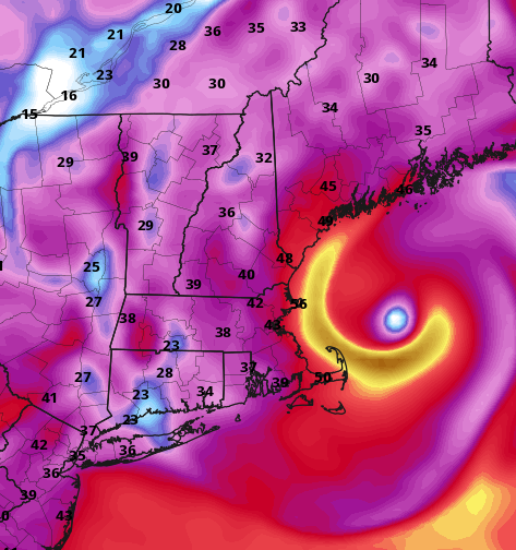
-
The last hurrah? Putting all the eggs in the Tuesday 3/14 basket
TalcottWx replied to Ginx snewx's topic in New England
I am truly right on the divider between fun and tears. It could be very messy.


