jsw
-
Posts
223 -
Joined
-
Last visited
Content Type
Profiles
Blogs
Forums
American Weather
Media Demo
Store
Gallery
Everything posted by jsw
-
Here, 54/23. Couldn't be nicer!
-
Oh, sounds like a good time to buy you a drink here in Brattleboro!
-
Oh...hello! NWS marine forecast for just E of Cape Cod: Sunday E wind 14 to 17 kt increasing to 17 to 20 kt in the afternoon. Winds could gust as high as 29 kt. A chance of showers. Seas 3 ft building to 5 ft. Sunday Night ENE wind 24 to 28 kt, with gusts as high as 36 kt. Showers likely. Seas 8 ft building to 13 ft. Columbus Day ENE wind 28 to 30 kt, with gusts as high as 40 kt. Showers likely. Seas 14 to 15 ft.
-
Right now, 35F and 32F dewpoint. Nice!
-
I posted .29 earlier, but that's KEEN, not Brattleboro. I don't have a rain gauge here. Thanks for the local total!
-
Grand total here: .29 inches. DIT was right, for my area. Heh. Kudos.
-
Thanks, I am way down South, and humidity is down to 56 percent (KEEN, across the river). Still, air 79F and dewpoint 62F. Overcast, warm and sticky.
-
This is odd, because relative humidity now here is 79 percent, dewpoint 60. Yes, it is dry, but Special Weather Statements says low humidity exacerbates the problem today. Maybe drying air as it clears up? But, yeah, a half inch of rain will be very beneficial here. Special Weather Statement National Weather Service Albany NY 229 AM EDT Tue Oct 7 2025 VTZ013>015-072100- Bennington-Western Windham-Eastern Windham- 229 AM EDT Tue Oct 7 2025 ...Fire Weather Concerns Exist Across Southern Vermont Today... Fine fuels remain very dry across Vermont today according to the Vermont Department of Forests, Parks and Recreation. Across southern Vermont, relative humidity values will be as low as 50 percent, while south to southwest winds will gust between 20 and 25 mph. If any fires were to start, the weather and fuel conditions could cause fires to quickly spread and become difficult to contain. For more information about the current fire danger rating, any burn restrictions, and wildfire prevention and education, please visit the Vermont forestry or environmental protection website. $$
-
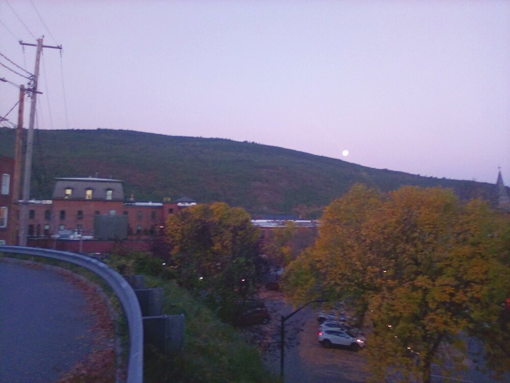
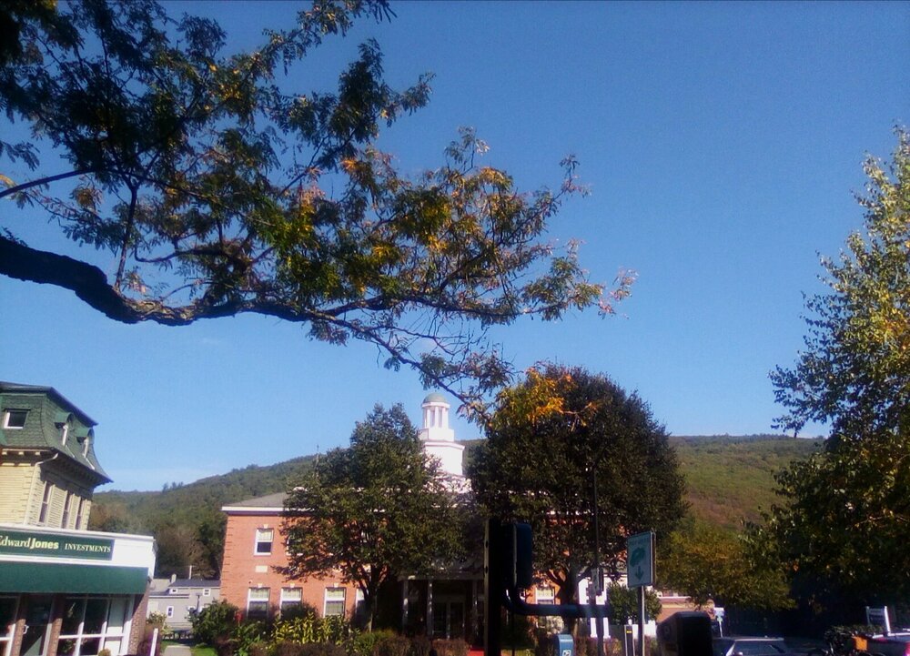
The night before full Harvest Moon rising over Mount Wantastiquet. This is my Kindle Fire. The camera doesn't handle low light very well, but otherwise it's a pretty spiffy camera.
-
Yup. These are my three quick go-to spots when rain or snow is coming: NWS KEEN this morning: Tuesday Patchy fog before 9am. Otherwise, mostly sunny, with a high near 80. Calm wind becoming south 5 to 7 mph in the morning. Tuesday Night Showers, mainly after 11pm. Low around 54. Southwest wind around 6 mph. Chance of precipitation is 100%. New precipitation amounts between a quarter and half of an inch possible. Wednesday Showers, mainly before 8am. High near 66. North wind around 6 mph. Chance of precipitation is 80%. New precipitation amounts between a quarter and half of an inch possible. Discussion: Clouds will gradually increase on Tuesday as a cold front approaches from the west. Moisture will increase ahead of the front as well with precipitable water values increasing to 1.25 to 1.50 inches (+2 to +3 STDEV). An upper level shortwave passing through the southwesterly flow aloft will increase forcing for ascent and allow for periods of rain, beginning Tuesday afternoon for areas north and west of Albany and areawide during Tuesday night. A rumble of thunder could occur with some of these showers for areas north and west of Albany Tuesday afternoon with weak instability present. Overall, most areas should pick up between 0.50 and 1.00 inches of rain but some higher amounts up to 2 inches could occur if any steadier and heavier periods of rain train over an area. Nonetheless, this will be a beneficial rain for the area which has seen another prolonged stretch of dry weather since our last rain event on September 25. Prior to the arrival of rain, temperatures should still rise into the 70s to around 80 on Tuesday, falling back to the 40s and 50s Tuesday night.

-
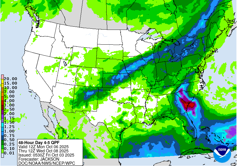
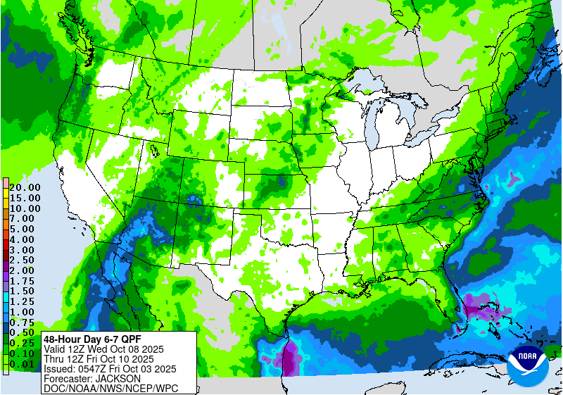
I posted the NWS discussion yeesterday, ad well ad HPC QPF graphics. Totals were increased a bit this morning, in the discussion (KEEN). No, not a drought buster, that would take a month, or months. Clearly, the forecast ise showers with the front, as of this morning a half inch or so. I will enjoy the showers....I feel like I live in a desert after this summer. I'll take whatever I can get.
-
Yup...yesterday in Brattleboro.
-
NWS now calling for 1" or more of rain Tuesday - Wednesday here. Nice!
-
From NWS just now, exerpt, Brattleboro: Tuesday Night Showers likely, mainly after 2am. Mostly cloudy, with a low around 57. Chance of precipitation is 70%. Wednesday Showers likely. Mostly cloudy, with a high near 68. Chance of precipitation is 60%. Wednesday Night A chance of showers. Partly cloudy, with a low around 40. Chance of precipitation is 30%. Discussion: While the dry and unseasonably warm trend continues into Monday, our attention then turns to a shortwave trough and associated sfc cold front progressing form southern Canada into the Northeast. Guidance has trended earlier with the start time of the rain ahead of the sfc boundary with most ensembles now suggesting rain spreads into areas north and west of Albany Tuesday evening before rain advances further east overnight. There remains uncertainty regarding the intensity of the shortwave trough tracking through Canada which will provide the necessary forcing for ascent to enhance the precipitation shield along the incoming boundary. Ensemble clusters suggest two types of scenarios. If the trough become neutrally to even slightly negatively tilted by Tuesday night, the CVA ahead of it should be strong enough to support a widespread soaking rain with 24-hr rainfall probabilities through 00 UTC Wed for near or above 0.50" ranging 50-70%. On the other hand, should the trough be weaker, limited CVA along the boundary will keep rainfall amounts lower with 24-hr rainfall probabilities for at or greater than 0.50" near or under 30%.
-
Right, I don't either, I consider an inch or more a good dousing. I kind of overstated due to enthusiasm and all the dryness this past summer.
-
Edit - I looked too quickly. Now I see 33 in Keene. We do get a little cooler here with radiational cooling. My last sentence still stands...ha. Huh, was I hallucinating this morning? First, rain chance gets nixed by some party pooper, now low in that graphic says 37F here, when I woke up to 31F (KEEN, closest station). We vary a little (lower elevation on CT Rive, 300 ft. above sea level). More coffee, please, or something stronger?
-
Oh. NWS Keene says 70 percent chance of showers for, I think Tuesday night for here in Brattleboro. Discussion last night said upwards of .25 inch. Have not read the discussion this morning but hey, we have you and others here...;). Will read it next...thanks!
-
At 6am, 31F air, 31F dewpoint. Second straight morning of 100 percent saturated air. Headed for 80F next four days, then it looks promising for a good dousing. Ahh, finally...variety!
-
Yes, totally. We kind of "acknowledged" each other when you moved up here a few years ago. I have lived here downtown since 2010, from Boston and Newton, Mass., born and raised, but have lived in a couple other cities over the years. I don't usually post much, just OBS during winter, but have a little time off from work while I take care of moving, birthday last month, busy stuff that I don't have time to do while working (thanks, Boss! :)). Anytime--coffee, BEER (ha), lemonade, whatever. Edit, forgot emoji.
-
Air 31F, dewpoint 31F at 6am. NWS forecast high is 61F, perfect weather for working outside! BTW, I just got a solid lead on a very nice apartment here in Brattleboro, so move to Northampton is on hold indefinitely. It was getting a bit complicated anyway, may as well keep it simple...
-
Here in Brattleboro, maples are all bright yellow, but everything else is green, mostly. If you look across the CT River at Mount Wantastiquet from town, it's a wall of mostly green still. It's like a straight up and down elevation change, about 300 feet (the river elevation ASL) to the summit (around 1,000 ft. ASL). If you're familiar, when it's peak color here, it's quite a colorful sight!
-
Downtown Brattleboro was also spectacular, but I didn't dig out my camera. I was on my way to an appointment. I just soaked it in.
-
Brattleboro now 75/47. Best kind of summer/late summer type weather. I know it's technically autumn, but it has been do freakin hot all summer! Oh yeah, I haven't even been looking at the local NWS forecast every morning as usual. It's almost the same every day...ha.
-
It is indeed awesome. I wore long pants for the first time in a while during the day, totally comfortable with t-shirt. Kinda sounds funny, but to me it means it's starting to cool off enough, a little, and I have always like fall and winter the best.
-
Edit to add: I just read the whole page on the link below (NOAA winter temp/precip forecast and ENSO bar chart and explanation). I found it, like a lot of stuff here, very informative and helpful, especially for a non-science, non-meteorologist like me. Just sayin', thanks... -- Most of this ENSO stuff is over my head, but I do enjoy reading Ray's and others winter forecasts and reasoning, and have for like 15 years plus. I learn, and if I even only "get" some of it, I come out ahead. Also, I am a big time winter enthusiast, you could say, it's my favorite time of year for a few of my favorite pastimes (surf, snowboard), and just having winter outside my window. I even like to shovel snow, ha. And for my landscaping company that I work for in Brattleboro, I do tractor snow clearing. It's fun. Anyway, this page was linked on Boston.com winter forecast article today. It has ENSO info, so figured it was OK to put here. I do not really like the forecast temp and snow this particular Web site (the one in the link) provides, but I am never one to "shoot the messenger." https://opensnow.com/news/post/noaa-2025-2026-winter-forecast


