WeatherGeek2025
-
Posts
1,682 -
Joined
-
Last visited
Content Type
Profiles
Blogs
Forums
American Weather
Media Demo
Store
Gallery
Everything posted by WeatherGeek2025
-

Extreme Cold, Snow & Sleet: SECS 1/24 - 1/26
WeatherGeek2025 replied to TriPol's topic in New York City Metro
euro was also consistent with last weekends system going out to sea -
Extreme Cold, Snow & Sleet: SECS 1/24 - 1/26
WeatherGeek2025 replied to TriPol's topic in New York City Metro
great point it's southeast and primary weaker kinda what the Goofus is implying! if we can get that primary transfer another 30-40 miles southeast we are golden this could stay all snow for nyc and north -
Extreme Cold, Snow & Sleet: SECS 1/24 - 1/26
WeatherGeek2025 replied to TriPol's topic in New York City Metro
warmest panel -
Extreme Cold, Snow & Sleet: SECS 1/24 - 1/26
WeatherGeek2025 replied to TriPol's topic in New York City Metro
the sleet gets stalled out around queens and manhattan it could be a trend overall a good run 8-10 inches followed by some sleet city and south -
Extreme Cold, Snow & Sleet: SECS 1/24 - 1/26
WeatherGeek2025 replied to TriPol's topic in New York City Metro
cmc is south by about 20 miles -
Extreme Cold, Snow & Sleet: SECS 1/24 - 1/26
WeatherGeek2025 replied to TriPol's topic in New York City Metro
cmc looks weaker stronger confluence from the high by Montreal -
Extreme Cold, Snow & Sleet: SECS 1/24 - 1/26
WeatherGeek2025 replied to TriPol's topic in New York City Metro
you always win!!!!!! -
Extreme Cold, Snow & Sleet: SECS 1/24 - 1/26
WeatherGeek2025 replied to TriPol's topic in New York City Metro
I would love for the GFS to verify but it's the outlier. I am going all in with Euro AI. if Euro AI verified it'd be 8-12 in the city followed by sleet which would keep my snow for weeks on the ground. I'm happy with that and there's more chances of snow down the road! -
Extreme Cold, Snow & Sleet: SECS 1/24 - 1/26
WeatherGeek2025 replied to TriPol's topic in New York City Metro
are we about to get NAM'd? -
Extreme Cold, Snow & Sleet: SECS 1/24 - 1/26
WeatherGeek2025 replied to TriPol's topic in New York City Metro
toms river i meant -
Extreme Cold, Snow & Sleet: SECS 1/24 - 1/26
WeatherGeek2025 replied to TriPol's topic in New York City Metro
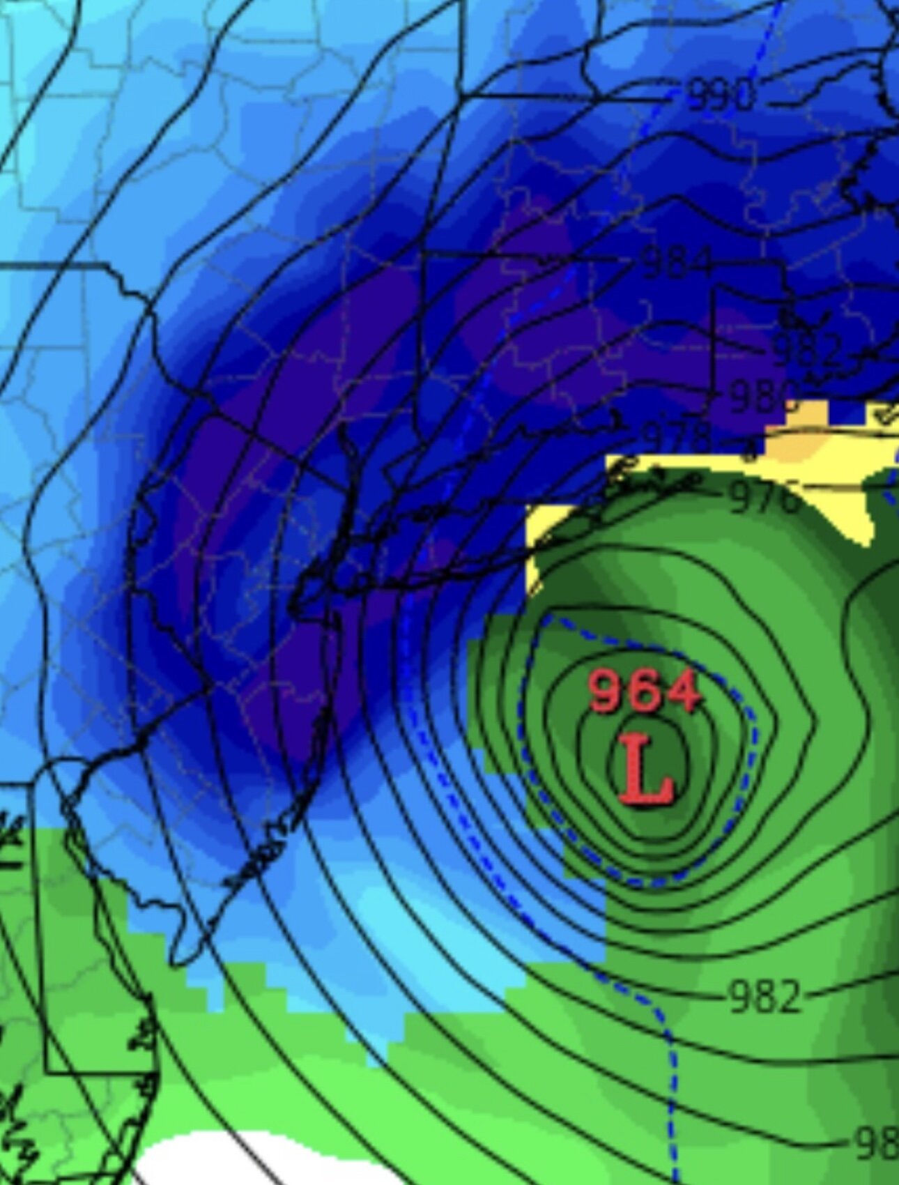
let's be realistic here for once the that i am wants to believe that but when models show that warm nose aloft, forget we will change to sleet from yorktown and south! Look for a trend that could push that warm nose down to let's say staten island or whatever. and boom we will all be happy. It could happen you want an earlier south transfer and you want that coastal to crank, that thing is a pos right now 1004 millibar low very weak at this time as it is being depicted. You want some type of 996 or lower for a chance to actually cool down those columns really quick and not have that warm nose creep north any further! -
Extreme Cold, Snow & Sleet: SECS 1/24 - 1/26
WeatherGeek2025 replied to TriPol's topic in New York City Metro
Stole this from NE @WeatherWillynot sure how accurate this model is NBM -
Extreme Cold, Snow & Sleet: SECS 1/24 - 1/26
WeatherGeek2025 replied to TriPol's topic in New York City Metro
GFS is all snow, and if we could push the other guidance 30-40 miles south we're good to go! -
“Cory’s in LA! Let’s MECS!” Jan. 24-26 Disco
WeatherGeek2025 replied to TheSnowman's topic in New England
thank you -
“Cory’s in LA! Let’s MECS!” Jan. 24-26 Disco
WeatherGeek2025 replied to TheSnowman's topic in New England
Guys driving, how does the EPS 0z run look? colder or warmer? same? -
Extreme Cold, Snow & Sleet: SECS 1/24 - 1/26
WeatherGeek2025 replied to TriPol's topic in New York City Metro
that's a great thing Euro AI is a good model probably the best i stand by it but maybe we're just going to get some sleet. But a 30 mile shift south could change the outcome to all snow. still another 72 hours until the first flakes come in. Plenty of time for that southern 30-40 mile shift! -
Extreme Cold, Snow & Sleet: SECS 1/24 - 1/26
WeatherGeek2025 replied to TriPol's topic in New York City Metro
right now as it stands every model shows 6-12 inches of snow followed probably by a bunch of sleet. The GFS is the only model that shows pure snow for the city and west if you use kuchera probably getting around 12-18 inches according to GFS. Hopefully the GFS is right. Even if the other models that are showing that warm nose aloft it's fine we're still getting a good amount of snow followed by heavy sleet which will have staying power for our snow cover for weeks! -
“Cory’s in LA! Let’s MECS!” Jan. 24-26 Disco
WeatherGeek2025 replied to TheSnowman's topic in New England
yeah that's true but if we can get GFS or iconic to be the real solution most on this and our forum would be happy -
“Cory’s in LA! Let’s MECS!” Jan. 24-26 Disco
WeatherGeek2025 replied to TheSnowman's topic in New England
by Saturday sleet might tickle dendrites behind -
“Cory’s in LA! Let’s MECS!” Jan. 24-26 Disco
WeatherGeek2025 replied to TheSnowman's topic in New England
i dunno the mix is trending north by saturday it's going to tickle dendrites behind -
Extreme Cold, Snow & Sleet: SECS 1/24 - 1/26
WeatherGeek2025 replied to TriPol's topic in New York City Metro
good morning i see stuff trended north this morning. still plenty of time for this to come a little south and hit us like the GFS! Id like to say this, i'd rather have GfS than Euro at this range! -
it's ok brother thank you
-
“Cory’s in LA! Let’s MECS!” Jan. 24-26 Disco
WeatherGeek2025 replied to TheSnowman's topic in New England
kinda like my snowmap too -
Extreme Cold, Snow & Sleet: SECS 1/24 - 1/26
WeatherGeek2025 replied to TriPol's topic in New York City Metro
read more and post less. i said the GFS was going to fold to euro ai and it did. honestly you post nothing of value besides try to dig knowledgeable posters. you should banter your jokes -
Extreme Cold, Snow & Sleet: SECS 1/24 - 1/26
WeatherGeek2025 replied to TriPol's topic in New York City Metro
gfs and icon almost identical cmc out to lunch


