WeatherGeek2025
-
Posts
1,682 -
Joined
-
Last visited
Content Type
Profiles
Blogs
Forums
American Weather
Media Demo
Store
Gallery
Everything posted by WeatherGeek2025
-

Extreme Cold, Snow & Sleet: SECS 1/24 - 1/26
WeatherGeek2025 replied to TriPol's topic in New York City Metro
i'd go with hrrr once in range. Nam sucks -
Extreme Cold, Snow & Sleet: SECS 1/24 - 1/26
WeatherGeek2025 replied to TriPol's topic in New York City Metro
-
“Cory’s in LA! Let’s MECS!” Jan. 24-26 Disco
WeatherGeek2025 replied to TheSnowman's topic in New England
-
Extreme Cold, Snow & Sleet: SECS 1/24 - 1/26
WeatherGeek2025 replied to TriPol's topic in New York City Metro
-
-
Extreme Cold, Snow & Sleet: SECS 1/24 - 1/26
WeatherGeek2025 replied to TriPol's topic in New York City Metro
hrrr -
Extreme Cold, Snow & Sleet: SECS 1/24 - 1/26
WeatherGeek2025 replied to TriPol's topic in New York City Metro
what's with the 6's? every decade big storm -
Extreme Cold, Snow & Sleet: SECS 1/24 - 1/26
WeatherGeek2025 replied to TriPol's topic in New York City Metro
snowman19 -
Extreme Cold, Snow & Sleet: SECS 1/24 - 1/26
WeatherGeek2025 replied to TriPol's topic in New York City Metro
if the mixing happens NYC and south. According to GFS New York doesn't change over at all! -
“Cory’s in LA! Let’s MECS!” Jan. 24-26 Disco
WeatherGeek2025 replied to TheSnowman's topic in New England
where's NY? I added your area on my snowmap! -
Extreme Cold, Snow & Sleet: SECS 1/24 - 1/26
WeatherGeek2025 replied to TriPol's topic in New York City Metro
isn't this the same snowstorm that a week or so ago GFS had 70 inches for someone in northern Pennsylvania? someone could end up with 36 inches if we get a big storm like the GFS! -
Extreme Cold, Snow & Sleet: SECS 1/24 - 1/26
WeatherGeek2025 replied to TriPol's topic in New York City Metro
Euro looks like it's trending to the GFS -
ScreenRecording_01-22-2026 17-27-23_1.mov
-
Extreme Cold, Snow & Sleet: SECS 1/24 - 1/26
WeatherGeek2025 replied to TriPol's topic in New York City Metro
ScreenRecording_01-22-2026 17-27-23_1.mov -
“Cory’s in LA! Let’s MECS!” Jan. 24-26 Disco
WeatherGeek2025 replied to TheSnowman's topic in New England
ScreenRecording_01-22-2026 17-27-23_1.mov -
Extreme Cold, Snow & Sleet: SECS 1/24 - 1/26
WeatherGeek2025 replied to TriPol's topic in New York City Metro
I'd rather have GFS by my side than Euro since their upgrade a few years back! -
Extreme Cold, Snow & Sleet: SECS 1/24 - 1/26
WeatherGeek2025 replied to TriPol's topic in New York City Metro
that would match my snowmap -
“Cory’s in LA! Let’s MECS!” Jan. 24-26 Disco
WeatherGeek2025 replied to TheSnowman's topic in New England
how much for nyc -
Extreme Cold, Snow & Sleet: SECS 1/24 - 1/26
WeatherGeek2025 replied to TriPol's topic in New York City Metro
8 inches for you -
Extreme Cold, Snow & Sleet: SECS 1/24 - 1/26
WeatherGeek2025 replied to TriPol's topic in New York City Metro
nam rolling -
Extreme Cold, Snow & Sleet: SECS 1/24 - 1/26
WeatherGeek2025 replied to TriPol's topic in New York City Metro
are they not seeing the sleet or they're counting the south trend -
Extreme Cold, Snow & Sleet: SECS 1/24 - 1/26
WeatherGeek2025 replied to TriPol's topic in New York City Metro
Long Island is getting way more than 4 inches -
Extreme Cold, Snow & Sleet: SECS 1/24 - 1/26
WeatherGeek2025 replied to TriPol's topic in New York City Metro
that looks south of 6z -
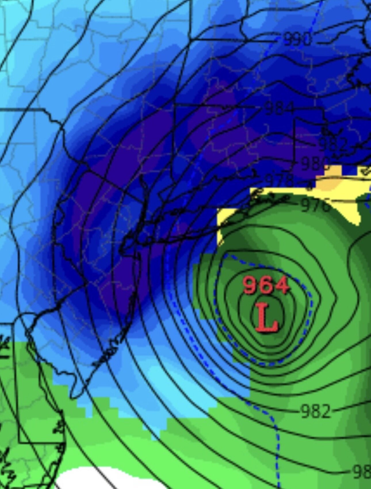
GFS shows a blizzard for next Sunday, Cmc shows snow and than a blizzard coming up the east coast by next sunday! This is a real winter!
-
Extreme Cold, Snow & Sleet: SECS 1/24 - 1/26
WeatherGeek2025 replied to TriPol's topic in New York City Metro
how's uncle what's it showing, driving to the city right now can't check. extrapolate the run if you don't mind ?


