simbasad2
-
Posts
41 -
Joined
-
Last visited
Content Type
Profiles
Blogs
Forums
American Weather
Media Demo
Store
Gallery
Everything posted by simbasad2
-
Central PA Fall Discussions and Obs
simbasad2 replied to ChescoWx's topic in Upstate New York/Pennsylvania
Here comes the cold front. 30s in western Pennsylvania; still rocking lower 60s in east Pennsylvania. Heavy showers and perhaps a rumble of thunder will accompany these storms!!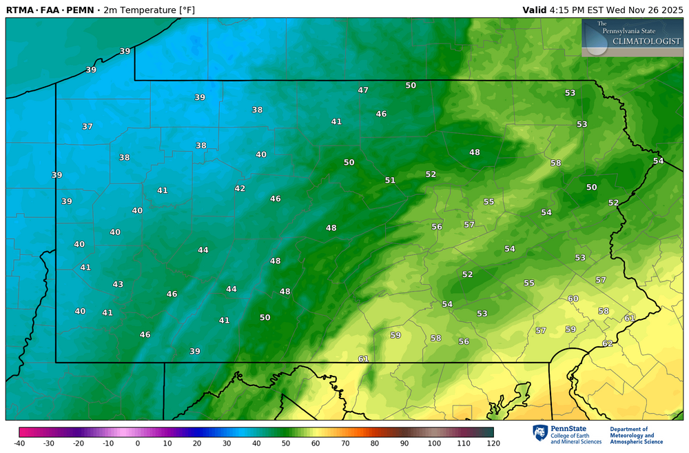
-
-
E PA/NJ/DE Autumn 2025 Obs/Discussion
simbasad2 replied to PhiEaglesfan712's topic in Philadelphia Region
The 12z GEFS ensembles arent terrible imo... -
E PA/NJ/DE Autumn 2025 Obs/Discussion
simbasad2 replied to PhiEaglesfan712's topic in Philadelphia Region
The ICON starts the 12z suite off with a pretty heavy ice storm for areas slightly NW of I-95 -
E PA/NJ/DE Autumn 2025 Obs/Discussion
simbasad2 replied to PhiEaglesfan712's topic in Philadelphia Region
FIRST DIGITAL SNOW OF THE SEASON!! -
This feels suspiciously too high. It's worth mentioning I've noticed the AIFS-ENS has a tendency to show snowfall in areas that are just really heavy rain no matter the temp. For instance, I remember Jamaica had a 1-2" snowfall mean right before Hurricane Melissa made landfall. I'd personally stick to the traditional ensembles until they can fix whatever this issue is
-
E PA/NJ/DE Autumn 2025 Obs/Discussion
simbasad2 replied to PhiEaglesfan712's topic in Philadelphia Region
When will the December 2025 and/or Winter 2025-26 board go up? -
E PA/NJ/DE Autumn 2025 Obs/Discussion
simbasad2 replied to PhiEaglesfan712's topic in Philadelphia Region
Well... I'd be lying if I said I wasn't surprised. Not sure if I said this here or just thought it to myself, but I was convinced that the early December torch signal was gonna break the streak of every E US Ridge trending into a trough. And that we were going to be flooded with 60s to start the meteorological season. Todays 18z suite so far looks to be an extension of the trends already present on the 12z runs. We might even have our first accumulating snow event of the season. Per the 18z GFS, a relatively weak shortwave will round the base of the longwave/TPV lobe and a fast moving system could bring some light snowfall for someone in the Mid-Atlantic or Northeast early next week. Hopefully this isn't a repeat of 2024-25 where everything does a mega south trend to Antarctica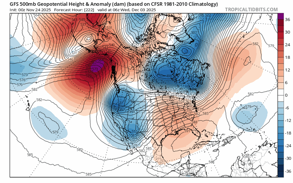
-
Also an emphasis on the name, "December LONG RANGE Discussion." A LOT can still change because we are in the LONG RANGE!! Especially when the pattern is so volatile and uncertain. People need to stop canceling winter so quickly
-
Also this is a vibeology thing more than a meteorology thing. A torchy 576dm ridge in the first week of December does not change the probability of a good pattern setting up at the end of December. The only reason this *would* be the case is if subseasonal and seasonal patterns were unfavorable which they won't be for Dec 2025.
-
All the signs in the world point to this not being the case this winter
-
I think people often forget that the beginning half of December is climatologically unfavorable for snow for the Mid-Atlantic
-
E PA/NJ/DE Autumn 2025 Obs/Discussion
simbasad2 replied to PhiEaglesfan712's topic in Philadelphia Region
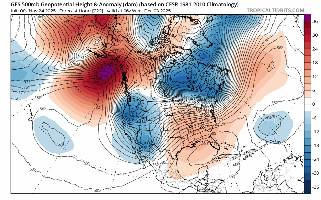
Is it too early to start looking at December? Unfortunately it seems like strong east coast ridging will kick off meteorological winter for us. Still far away, but most long range ensemble guidance supports temps reaching the 50s-70s. Thankfully short lived though as a really cold air mass will advect eastward by around December 5th. EPS Weeklies support a weak SER around this time, so maybe some overunning events next month? -
E PA/NJ/DE Autumn 2025 Obs/Discussion
simbasad2 replied to PhiEaglesfan712's topic in Philadelphia Region
There was actually some pretty decent ensemble support earlier this week of an amplified shortwave to emerge behind the Thanksgiving system around the weekend of 11/29-30. Unfortunately this looks unlikely now -
E PA/NJ/DE Autumn 2025 Obs/Discussion
simbasad2 replied to PhiEaglesfan712's topic in Philadelphia Region
21z HRRR run from today. Looks like the rain/snow line has shifted a hair south compared to earlier runs along with precipitation totals for everyone regardless of p-type. I don't think we'll have as amped of a solution as modeled but still can't rule out a grassy coating for the N of I-78 folks -
If these weeklies verify then the 2nd half of December is game on for the Northeast and Mid-Atlantic in my opinion. Especially with the MJO entering phase 8 by that time