wake4est
-
Posts
950 -
Joined
-
Last visited
Content Type
Profiles
Blogs
Forums
American Weather
Media Demo
Store
Gallery
Everything posted by wake4est
-
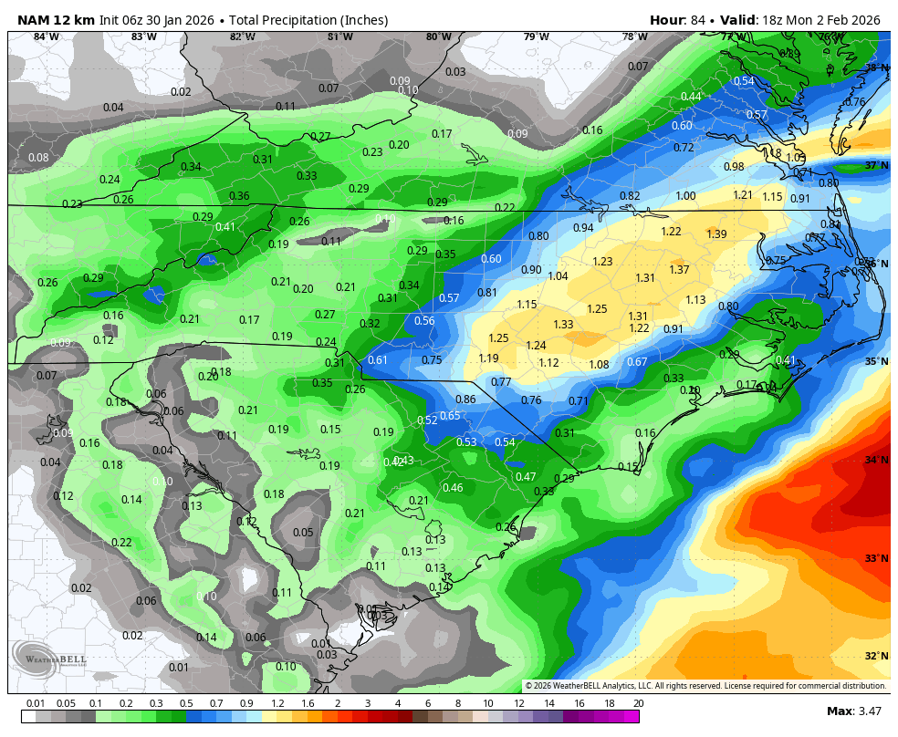
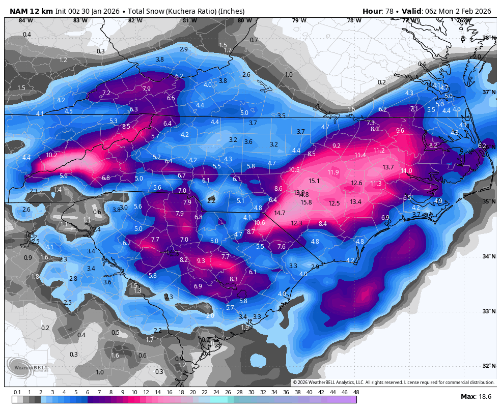
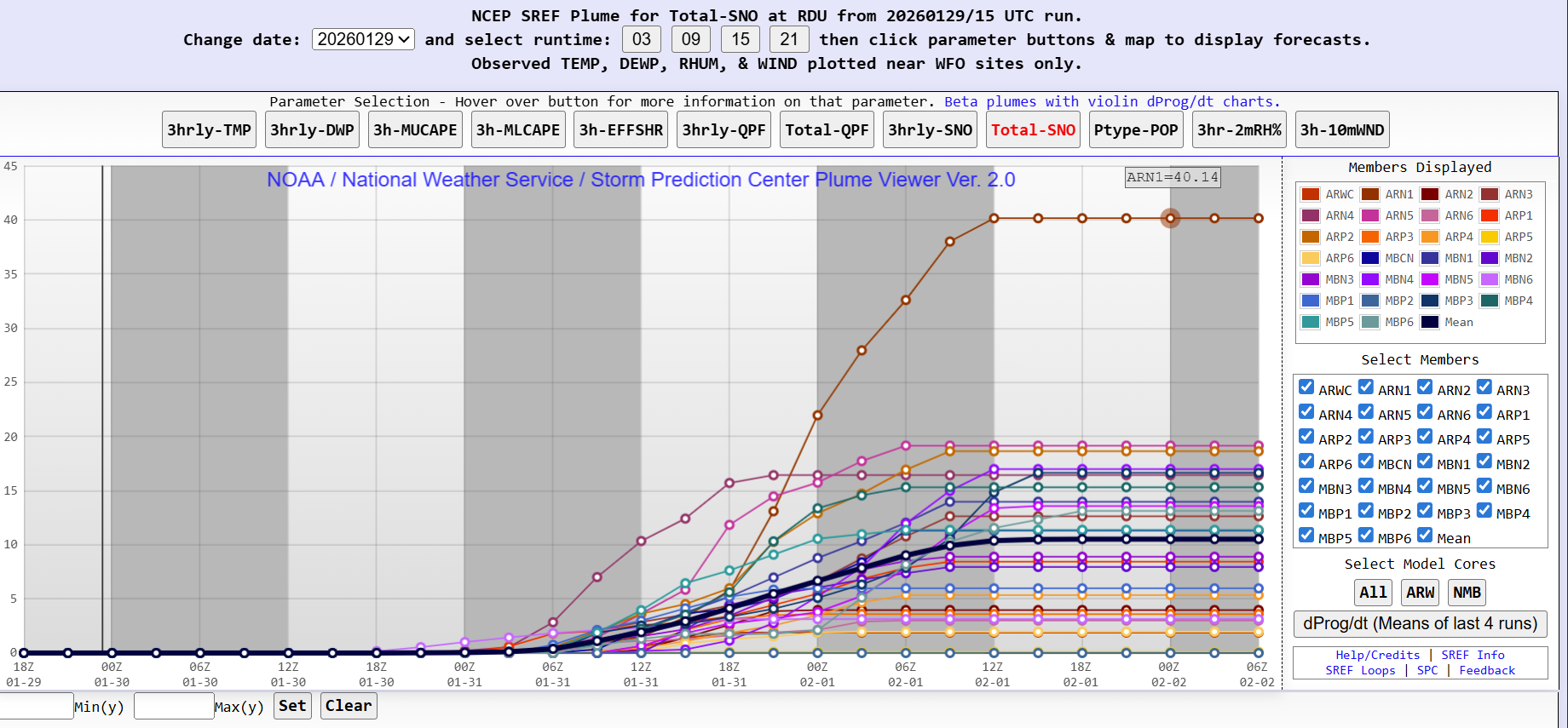
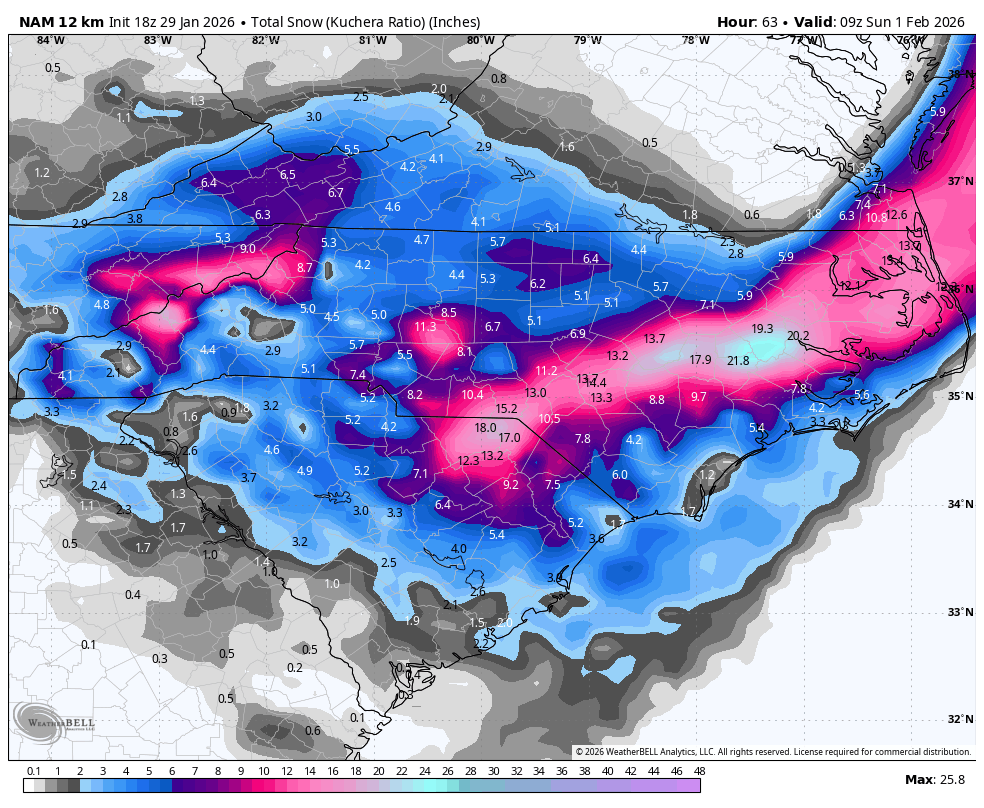
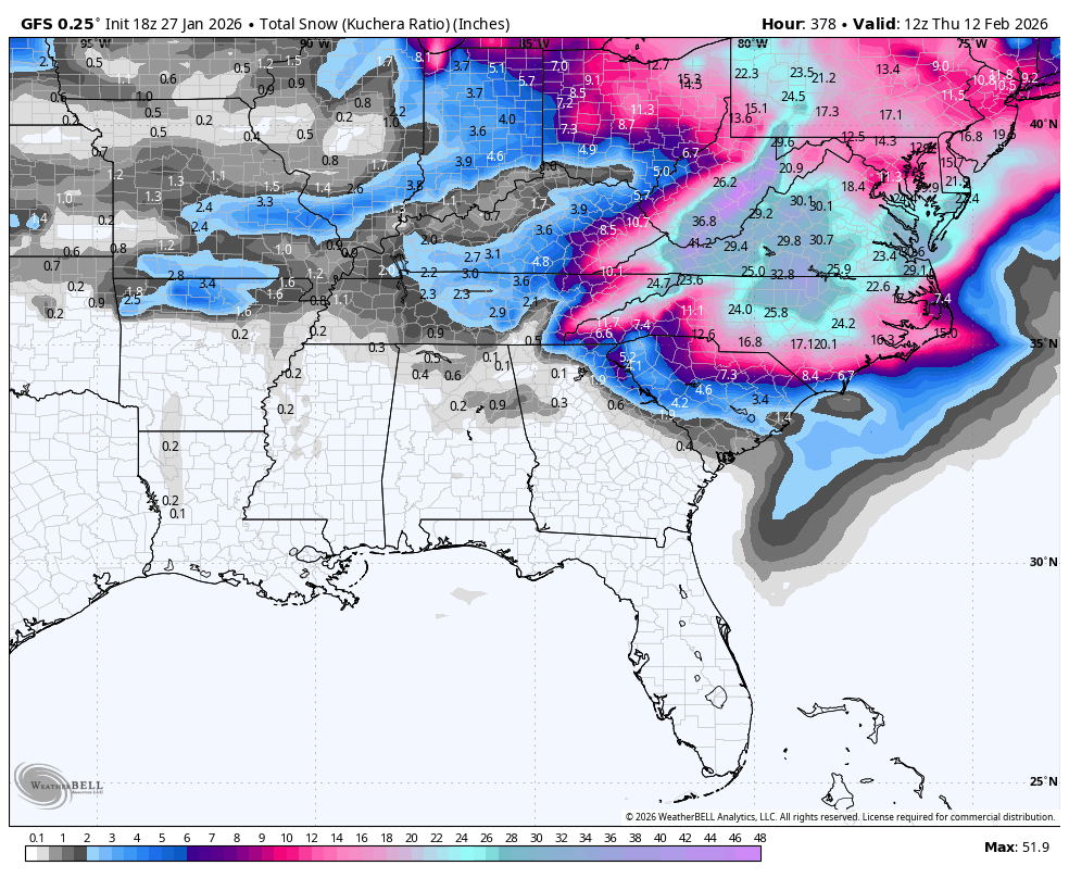
The “I bring the mojo” Jan 30-Feb 1 potential winter storm
wake4est replied to lilj4425's topic in Southeastern States
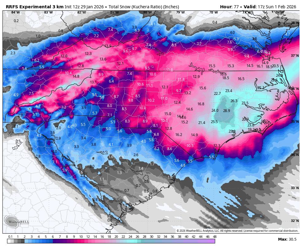
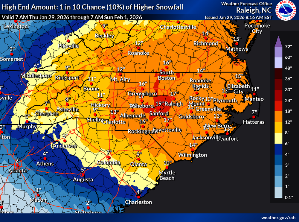
SREF Plumes for RDU have the median at 12.5" -
The “I bring the mojo” Jan 30-Feb 1 potential winter storm
wake4est replied to lilj4425's topic in Southeastern States
thru 39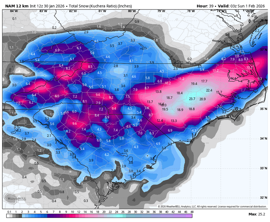
-
The “I bring the mojo” Jan 30-Feb 1 potential winter storm
wake4est replied to lilj4425's topic in Southeastern States
thru 33 she's already dropped 9" on Raleigh -
The “I bring the mojo” Jan 30-Feb 1 potential winter storm
wake4est replied to lilj4425's topic in Southeastern States
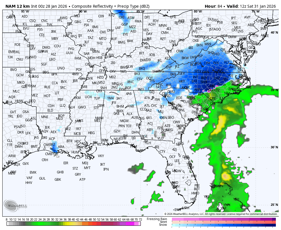
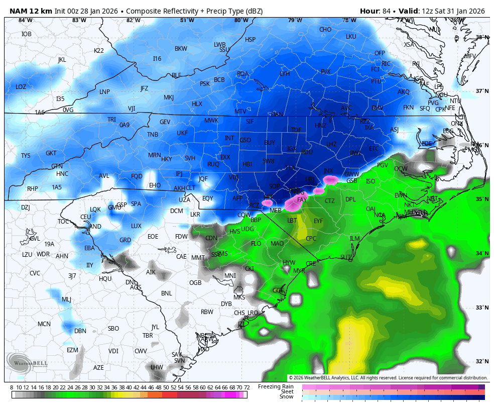
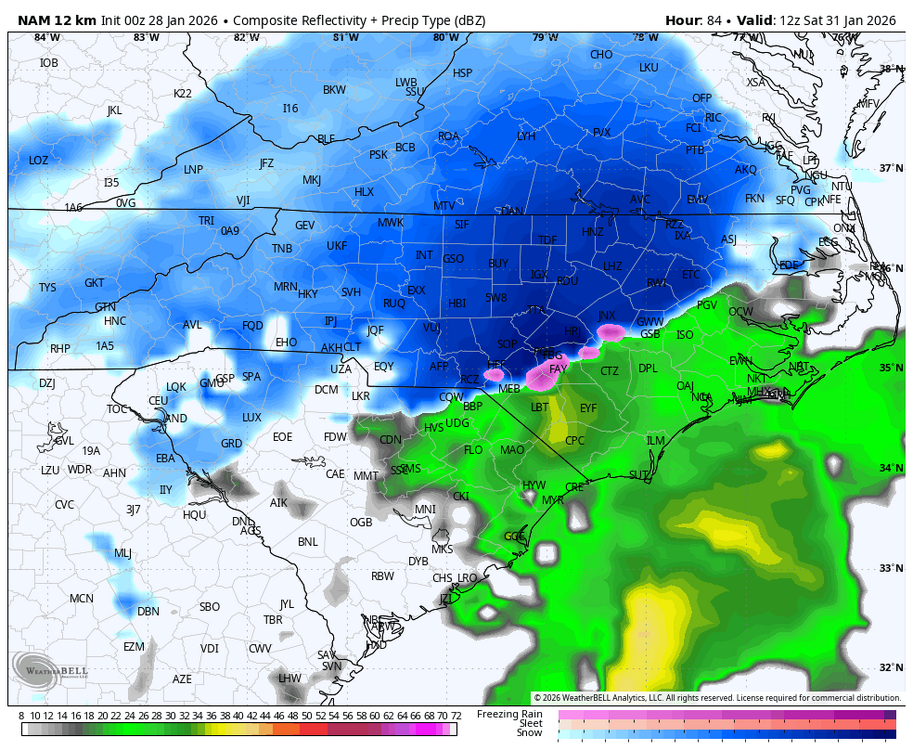
NAM looks good. -
The “I bring the mojo” Jan 30-Feb 1 potential winter storm
wake4est replied to lilj4425's topic in Southeastern States
It really does. Seeing the NAM and HRRR dropping bombs on the day the event starts is insane.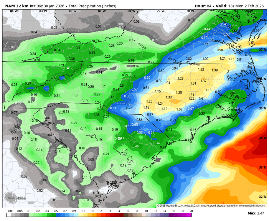
-
The “I bring the mojo” Jan 30-Feb 1 potential winter storm
wake4est replied to lilj4425's topic in Southeastern States
I would assume if short range stays consistent today they would boh nudge things to correct for that. -
The “I bring the mojo” Jan 30-Feb 1 potential winter storm
wake4est replied to lilj4425's topic in Southeastern States

-
The “I bring the mojo” Jan 30-Feb 1 potential winter storm
wake4est replied to lilj4425's topic in Southeastern States
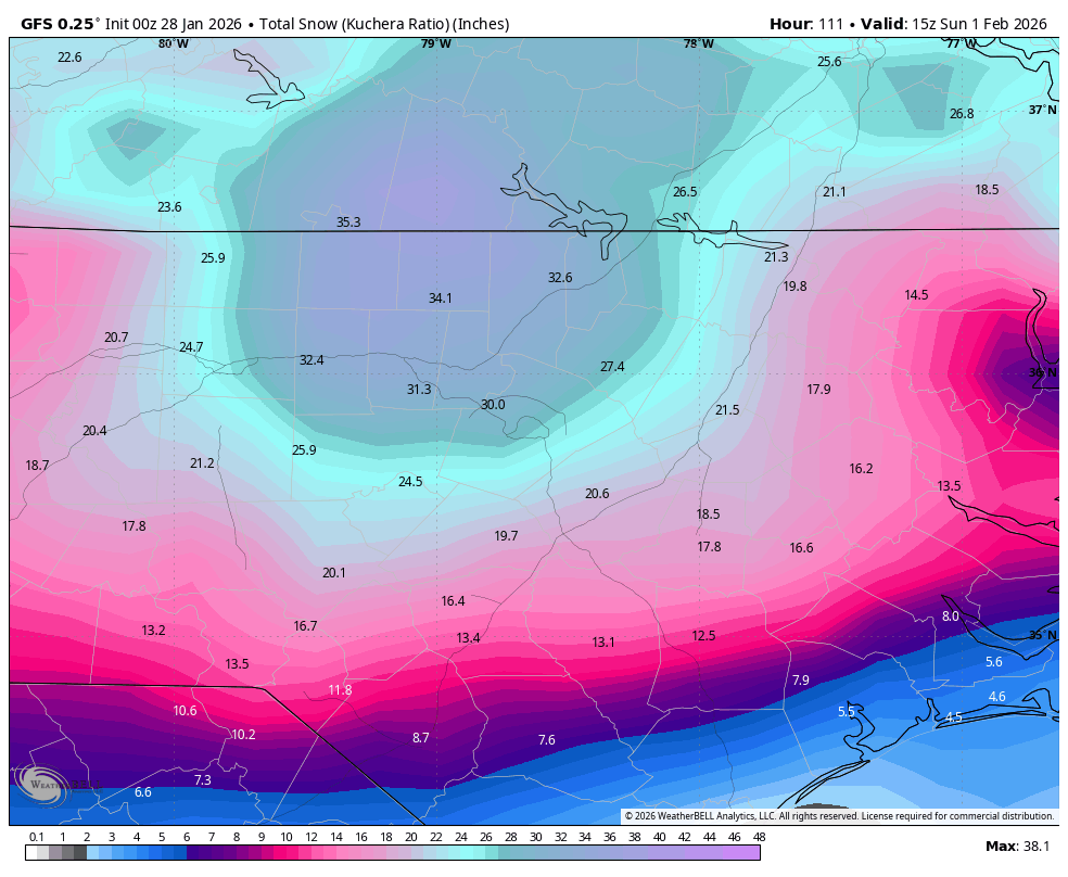
Who do we talk to about getting that one rogue member on the sref plumes showing 40"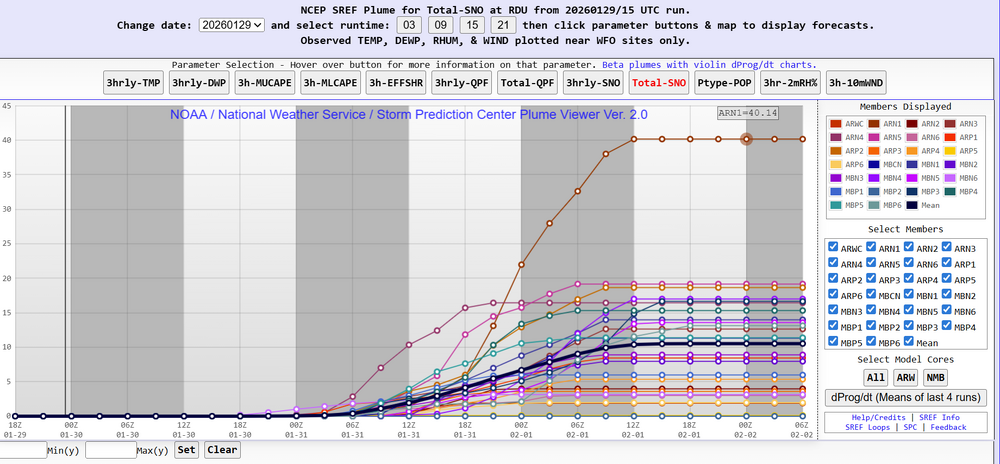
-
The “I bring the mojo” Jan 30-Feb 1 potential winter storm
wake4est replied to lilj4425's topic in Southeastern States
When will RAH kick off the Winter Storm Warnings? -
The “I bring the mojo” Jan 30-Feb 1 potential winter storm
wake4est replied to lilj4425's topic in Southeastern States

-
The “I bring the mojo” Jan 30-Feb 1 potential winter storm
wake4est replied to lilj4425's topic in Southeastern States
This is a Miller A, not a Miller B. -
The “I bring the mojo” Jan 30-Feb 1 potential winter storm
wake4est replied to lilj4425's topic in Southeastern States
-
The “I bring the mojo” Jan 30-Feb 1 potential winter storm
wake4est replied to lilj4425's topic in Southeastern States

-
The “I bring the mojo” Jan 30-Feb 1 potential winter storm
wake4est replied to lilj4425's topic in Southeastern States
-
The “I bring the mojo” Jan 30-Feb 1 potential winter storm
wake4est replied to lilj4425's topic in Southeastern States
-
The “I bring the mojo” Jan 30-Feb 1 potential winter storm
wake4est replied to lilj4425's topic in Southeastern States

-
The “I bring the mojo” Jan 30-Feb 1 potential winter storm
wake4est replied to lilj4425's topic in Southeastern States

-
The “I bring the mojo” Jan 30-Feb 1 potential winter storm
wake4est replied to lilj4425's topic in Southeastern States
During the lull, I just want to say how epic the 18z suite was.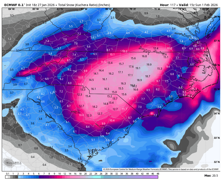
-
Southern Crippler - Get well soon Jimbo Storm Obs
wake4est replied to BooneWX's topic in Southeastern States
Snow in Cary -
Southern Crippler - Get well soon Jimbo Storm Obs
wake4est replied to BooneWX's topic in Southeastern States
35 degrees, 0.8 BAC -
No, I believe it is ISW criteria PLUS the presence of snow and sleet that upgrades that to a WSW. I could be wrong tho.
-
I think they did the WSW instead of an ISW because of the presence of snow and sleet at onset.
-
JMA gives the Triangle to the NW 1.5-1.8" qpf it's quiet in here
-
Daaaaaaaaang
-
RAH Issues Winter Storm Warning for rest of central NC ...WINTER STORM WARNING IN EFFECT FROM 7 PM SATURDAY TO 1 PM EST MONDAY... * WHAT...Heavy mixed precipitation of largely sleet and freezing rain expected. Total ice accumulations between three tenths and three quarters of an inch. Total sleet and snow accumulations up to two inches. * WHERE...For much of the Piedmont and northern Coastal Plain of central North Carolina. * WHEN...From 7 PM Saturday to 1 PM EST Monday. * IMPACTS...Significant ice accumulation on power lines and tree limbs may cause widespread and long-lasting power outages. Travel could be treacherous. The hazardous conditions could impact the Monday morning commute. PRECAUTIONARY/PREPAREDNESS ACTIONS... Persons should consider delaying all travel. If travel is absolutely necessary, drive with extreme caution. Consider taking a winter storm kit along with you, including such items as tire chains, booster cables, flashlight, shovel, blankets and extra clothing. Also take water, a first aid kit, and anything else that would help you survive in case you become stranded.