
Lava Rock
-
Posts
11,637 -
Joined
-
Last visited
Content Type
Profiles
Blogs
Forums
American Weather
Media Demo
Store
Gallery
Posts posted by Lava Rock
-
-
18 minutes ago, tamarack said:
Lots of snow in 95-96, its 138.8" was tops of my 13 winters in Gardiner by 30". That trails only 2007-08 since moving from Fort Kent in 1985. However, the major thaws, especially in January, tempered my enthusiasm.
Five top SDDs for Gardiner winters:
1993-94 1,993
1986-87 1,879
1989-90 1,641
1992-93 1,352
1995-96 1,290what a great winter that was on great pond. except for the big screamer that yr.
-
49.6F. 50+ should be easy
-
1 minute ago, alex said:
Warmup was short lived, changing back to snow here. All in all, a great storm and a nice net gainer of heavy base snow
cover that grille. the door is ri
 pped off too
-
suns out. let's torch the rest
-
 1
1
-
-
42 minutes ago, tunafish said:
2.51" Rain
Pack was 8" at midnight; 2" at 7AM.
saw a guy last night nordic skiing at Riverside course when I left work. he knew it would be short lived
-
 1
1
-
-
SR and SL both reporting 14"
-
1
-
-
3 minutes ago, Great Snow 1717 said:
Does anyone else miss the days of when the Montreal Express roared in after a storm????
yes, but somewhat happy no big temp drop today otherwise these wagon wheels would freeze up solid
-
1 hour ago, 40/70 Benchmark said:
This is kind of what I was getting at last night....the runs are consistently sucking. I can beat off to H5 animations for only so long...I'd like to see some favorable deterministic solutions mixed in.
mreeves telling people to whack off to snow maps, you jerking it to short movies. this place always good for a laugh
-
3
-
-
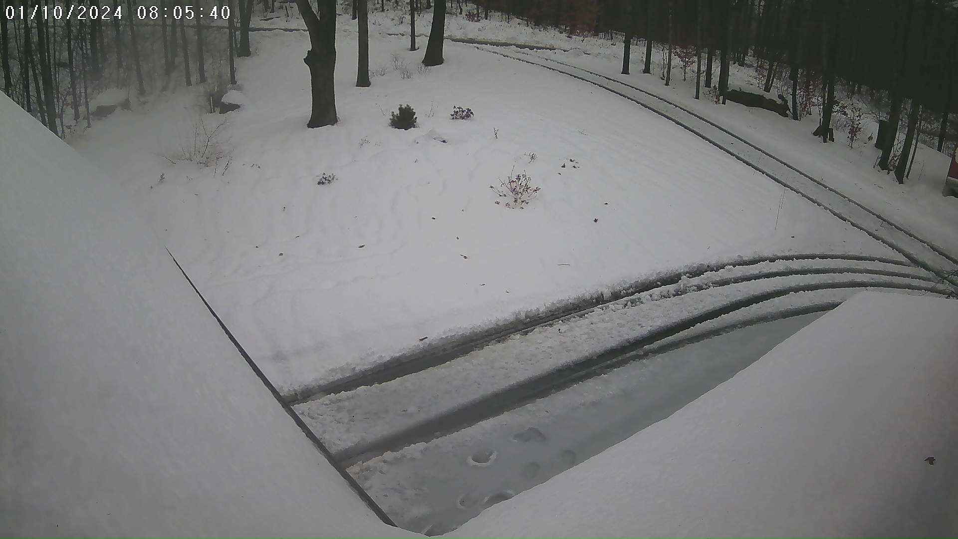
Got up at midnight, went out in my scivvys and measured 5". Was still Pounding and not sure when it flipped. Some decent gusts atm but pack still intact. 41f
Sent from my SM-G981U1 using Tapatalk -
5". Too bad it can't stay all sn
Sent from my SM-G981U1 using Tapatalk-
1
-
-
Temp on the rise. 27.1f. 1". Pounding
Sent from my SM-G981U1 using Tapatalk-
1
-
-
Sn. 25.2F
Sent from my SM-G981U1 using Tapatalk-
1
-
-
Let it wash away. Local met says rn here by 5am. I was going to get up and snowblow but screw itPallets going to Nix in now. Unless we can flip back with some heavier risers it looks like 2.25” will do it.
The question is do I try clearing the driveway or hope that it washes away? I’m under the weather so I really don’t feel like attempting the former.
Sent from my SM-G981U1 using Tapatalk
-
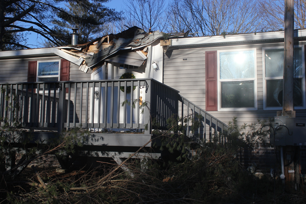
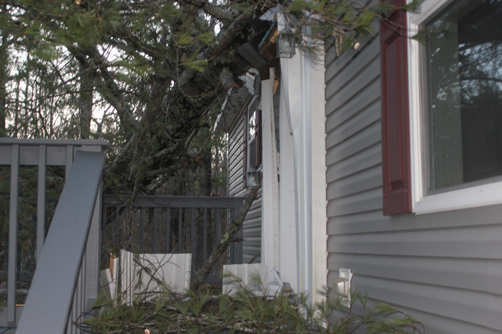
17 minutes ago, NoCORH4L said:
Too close to the house.... But I should talk, got a couple over my garage
there's 4 or 5 more, they're all along the road. they had one removed on the property last year around the dog kennel and that was pricey.
-
 1
1
-
-
24 minutes ago, Layman said:
Unfortunately, I've got some big pines real close to the house. Four on my property that could be a problem with a robust N/NE wind which we thankfully rarely get here.
My Mom had a large pine hit her house on the 18th and did significant damage. Luckily she wasn't hurt. We don't need those bog winds despite some calling for destruction
-
2
-
3
-
-
1 hour ago, Hazey said:
We need these two cutters to reset things, then its' go time. Sucks but a week will be here and gone in short order. Just hope there is minimal damage in between.
wasn't the same said on dec 17th? just another cutter away from winter commencement
-
what a massive wall of precip coming
-
1
-
1
-
-
1 hour ago, Layman said:
Is she gonna let us out?
nope.

-
1
-
-
23 minutes ago, klw said:
So for later today and tomorrow I have a Winter Weather Advisory, Flood Watch, High Wind Warning, Wind Chill Warning, Heat Advisory, Flash Freeze Warning, Migrating Geese Warning, and Wooly Caterpillar watch. Does that sum things up?
welcome to NE
-
 1
1
-
-
30 minutes ago, NW_of_GYX said:
Nothing like 7” 7:1 snow with an inch of water added to it for good measure. Should be a joy to clean up.
I'm thinking of snowblowing around 6am before the changeover. If I don't get it off the driveway, it'll be a frozen wagon wheels mess.
-
25 minutes ago, dryslot said:
URGENT - WINTER WEATHER MESSAGE
National Weather Service Gray ME
511 AM EST Tue Jan 9 2024

MEZ012-020-021-033-NHZ004-006-092215-
/O.UPG.KGYX.WS.A.0002.240110T0000Z-240110T1500Z/
/O.NEW.KGYX.WS.W.0002.240109T2200Z-240110T1200Z/
Southern Oxford-Androscoggin-Kennebec-Interior Cumberland
Highlands-Northern Carroll-Southern Carroll-
Including the cities of Bethel, Newry, Bridgton, Greene,
Fryeburg, Bryant Pond, Sidney, Vassalboro, Palermo, Auburn,
Conway, Bridgewater, China, Minot, Tuftonboro, Turner, Ossipee,
Wakefield, Jackson, Windsor, Albany, Wales, Waterville, Crawford
Notch, Augusta, Locke Mills, Livermore Falls, Rumford, Norway,
Naples, Brookfield, North Conway, Milton, Wolfeboro,
Moultonborough, Harrison, Oxford, Lewiston, Sabattus, Chatham,
and Hanover
511 AM EST Tue Jan 9 2024

...WINTER STORM WARNING IN EFFECT FROM 5 PM THIS AFTERNOON TO 7 AM
EST WEDNESDAY...

* WHAT...Heavy snow and mixed precipitation expected. Total snow and
  sleet accumulations between 5 and 17 inches, with highest totals
  occuring at higher elevations. Winds gusting as high as 50 mph
  after snow has fallen.

* WHERE...Portions of south central, southwest, and western Maine
  and northern New Hampshire.

* WHEN...From 5 PM this afternoon to 7 AM EST Wednesday.

* IMPACTS...Significant snowfall and periods of heavy snowfall rates
  will combine with low visibility to create very dangerous driving
  conditions. Heavy, wet snow will cause weighted tree limbs of
  conifers and leafed trees, leading to snapped branches. Snow will
  change over to rain, with a period of sleet and/or freezing rain
  at transition which will cause slushy roads and further degrade
  driving conditions. Plan on delaying travel to allow time for road
  conditions to improve. The hazardous conditions will impact the
  Wednesday morning commute.

Winds are expected to become strong and gusty as snow transitions to
rain. The combination of fallen snow clinging to branches and power
lines and increasing winds will likely lead to additional power
outages.

PRECAUTIONARY/PREPAREDNESS ACTIONS...

If you must travel, keep an extra flashlight, food, and water in
your vehicle in case of an emergency. The latest road conditions can
be obtained by going to newengland511.org

&&

$$
not what the clubs need. bridges are finally getting repaired or are repaired, now a bunch of trees will be coming down. this past yr has been the worst for trail maintenance
-
2
-
-
25 minutes ago, amc said:
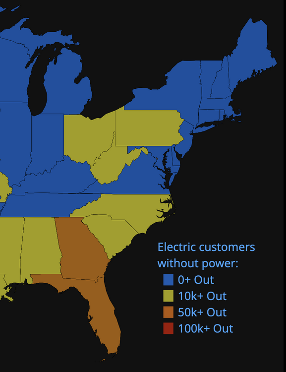
Wind numbers for my area starting to finalize. Looks like not much beyond the immediate coast here in ME, CMPCO will still mange to just about blackout the whole state probably...
good. 3 day outage last time on tenny hill
-
JinxDon't do it.
Sent from my SM-G981U1 using Tapatalk
-
1
-
-
20 minutes ago, PowderBeard said:
I wouldn't be surprised if GYX's current high end map is realized. It's going to come in up here with a hell of a thump and could easily hang on to that cold air longer than expected.
I hope so, but either way not sure about getting the sn cleared off the driveway. Slop fest at the end and looks warm enough Thurs to melt a lot of it, but near our garage barely ever gets sun, so if it freezes, it's a real pain later in the season

January 2024 -- Discussion
in New England
Posted
33F. Can't even get to sub 32 approaching coldest time of year. Ant wait to look back end of March and say that early Dec had coldest morning low
Sent from my SM-G981U1 using Tapatalk