

IrishRob17
-
Posts
11,753 -
Joined
-
Last visited
Content Type
Profiles
Blogs
Forums
American Weather
Media Demo
Store
Gallery
Posts posted by IrishRob17
-
-
4 hours ago, bluewave said:
Updating for July 2026 with several spots in the northern forecast zones going over 10.00” for the month.
https://dex.cocorahs.org/stations/NY-PT-2
Viewing Station: NY-PT-2 : Beacon 4.2 ESEMonth-To-Date: 16.30"
11.49" IMBY, first double digits since 10.52 is September 2023.
-
 1
1
-
-
'Only' 1.57" here, 11.41" for the month.
-
Saw a tree down in Goshen and there are various twigs and small branches down in my yard yet again, the theme of this summer. Up to 10.17” for the month and counting.
-
5 minutes ago, Brian5671 said:
I'm hoping it misses here-the big totals-still alot of cleanup ongoing after last week's flooding/damage
Hoping for a miss here as well, close to 10" here for July at this point.
-
3
-
-
21 minutes ago, Hitman said:
gorgeous weather. Much appreciated but I think any talk of summer's back being broken is a tad premature.
Certainly going to fully enjoy the next few days!
-
1
-
-
49 minutes ago, hudsonvalley21 said:
That cell that moved thru was a gully washer by you around 9:30. I just got clipped by it. Total of 1.48 in the Davis for yesterday here.
edit: rain shower currently and a few more out there for today.
Another water (not too much) into the basement storm too.
-
1
-
-
Just now, BobbyHolikWillFindYou said:
Mosquito eruption incoming?
That already happened up here, its right up there with the worst I've ever seen. Yesterday will only prolong that misery.
-
2
-
-
Just now, MANDA said:
Don't have any information on rainfall rates here. My period of record here is just about 9 years. Will have to go back and look to see what my wettest month was. Good question.
My records go back to 2005.
-
3 minutes ago, MANDA said:
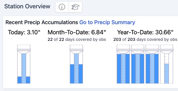
Total for yesterday 3.10". Two rounds. Early morning 1.72" in about 45 minutes. Second round with tornado warned storm early afternoon dropped 1.37" in about 15 minutes. Finished with .01" during the evening in a quick moving light shower.
I'm good with rain for a while. Need some time for the ground to dry out. No need to water here anytime soon. Everything is as green as it could possibly be.
@bluewave posted above the next big ridge looks to be centered more west over the western plains or Rockies. Watch for weak downstream trof over the east. Depending on placement that could signal another round of wet weather. A trof axis over the Ohio Valley or along the Appalachians would make for a wetter go around here.
Do you happen to have any rainfall rate information from your station? I'm at 9.74" for the month making it the second wettest July for me, only topped by 2023 with 13.95". My average is 4.85". Interesting to note that I had .08" more in the Stratus than in the Davis which had to be due to splash out from the Davis in the 12.52" per hour rate for five minutes followed by a 11.76" rate for five minutes around 9:30pm last night.
-
1
-
-
The 9.74" makes it the second wettest July for me, only topped by 2023 with 13.95". My average is 4.85". Interesting to note that I had .08" more in the Stratus than in the Davis which had to be due to splash out from the Davis in the 12.52" per hour rate for five minutes followed by a 11.76" rate for five minutes around 9:30pm last night.
-
2
-
-
1.79" for the day and 9.74" for the month. We can get some stretches of dry weather now, please and thank you.
-
14 minutes ago, IrishRob17 said:
We're getting a last hurray for the day, we could put me over 9" for the month.
1.79" for the day with 9.74" for the month.
-
1
-
-
5 minutes ago, snywx said:
2.75” for the day
1.5 in the last 30 mins. Impressive
We're getting a last hurray for the day, we could put me over 9" for the month.
-
2
-
-
.67" today, 8.62" for the month.
-
1
-
-
50 for the low here, I see 48 up the road at KMGJ, I nice break from the warmth.
-
2 hours ago, Juliancolton said:
I'm sure it's been said already but today's feeling a bit autumnal. Can you break summer's back before Aug?
I saw someone on the NE side mention “shot across the bow” and I chuckled. A beauty of a day for sure.
-
1
-
-
4 minutes ago, weatherwiz said:
Yesterday didn’t really bust. The greatest threat for severe weather was off to the West, in which there were a quite a few reports, including at least one tornado. Threat was always lower here and worth watching.
I saw a video from around Deposit, NY of damage from that tornado. I’ll be curious what the rating will be on it.
-
1
-
-
It was a good call postponing Freedom Fest until Saturday 7/25. Nothing severe here thankfully, a .36” total, 7.95” for the month, and heavy heavy mosquitoes thanks to the deluge from a couple weeks ago. @crossbowftw3I saw the Tornado Warnings yesterday and saw footage of the damage around Deposit, hope you made out ok.
-
1
-
-
Just now, NJwx85 said:
Just wanted to clarify since some would assume it covered the entire days activities.
That’s fair, I like to think most of us here understand how these discussions work but weenies may not. The clouds and smoke as mentioned will obviously help tell the story of what may or may not happen later.
-
1 minute ago, NJwx85 said:
This is only regarding the morning threat.
You don’t say
-
https://www.spc.noaa.gov/products/md/md1645.html

Mesoscale Discussion 1645
   NWS Storm Prediction Center Norman OK
   1001 AM CDT Sat Jul 18 2026

   Areas affected...Northern Mid-Atlantic into southern New England

   Concerning...Severe potential...Watch unlikely

   Valid 181501Z - 181630Z

   Probability of Watch Issuance...20 percent

   SUMMARY...Isolated wind damage is possible with strong to marginally
   severe storms late this morning. A watch is not expected.

   DISCUSSION...A small linear cluster of storms has recently organized
   in northern New Jersey and adjacent northeast Pennsylvania. Storm
   cores have shown modest deepening on 7 km MRMS CAPPI over the last
   30 minutes. The observed OKX sounding had poor mid-level lapse rates
   (5.3 C/km) but 45 kt of effective shear. Downstream of this current
   activity, cloud cover and smoke have hindered surface heating.
   Low-level lapse rates are not expected to be overly steep. While
   isolated wind damage is possible late this morning, the severe
   threat should remain marginal on account of very limited buoyancy. A
   watch is not expected.

   ..Wendt/Thompson.. 07/18/2026
-
14 minutes ago, qg_omega said:
Close to zero here to your south
The ground smoke mixed out here hours ago too.
-
Satellite shows the smoke has pushed south but it’s deceiving, still lots of lingering ground level smoke easily seen when outside.
-
1
-
-
Looks like GOES-East might be back.
-
1
-
Interior NW & NE Burbs 2026
in New York City Metro
Posted
After some more showers last evening and this morning I'm at 11.73" for July.