

PhiEaglesfan712
-
Posts
789 -
Joined
-
Last visited
Content Type
Profiles
Blogs
Forums
American Weather
Media Demo
Store
Gallery
Posts posted by PhiEaglesfan712
-
-
Record high temperatures expected in London, for the start of Wimbledon: https://www.espn.com/tennis/story/_/id/45595840/wimbledon-readies-scorching-start-contingencies-place
"The previous record temperature for the start of the grass-court major was set in 2001 at 85 degrees. Monday's expected blast of heat could even surpass the tournament record of 96.3 degrees set in 2015."
So, it's possible that we could see record highs be smashed by over 11 degrees F.
-
 1
1
-
-
11 hours ago, Stormchaserchuck1 said:
Look at this -PDO taking shape

Taking shape? Haven't we've been in a -PDO for at least the last 5.5 years, since January 2020?
2020 -1.41 -1.48 -1.75 -1.32 -0.53 -0.75 -0.92 -1.33 -1.04 -0.62 -1.58 -0.99
2021 -0.61 -1.09 -1.67 -1.84 -2.04 -1.82 -2.00 -0.95 -1.96 -3.13 -2.75 -2.71
2022 -2.40 -1.91 -1.67 -2.09 -2.24 -1.32 -2.64 -2.38 -2.29 -1.81 -2.41 -2.21
2023 -1.24 -1.65 -2.45 -3.07 -2.42 -2.53 -2.52 -2.47 -2.99 -2.23 -1.79 -1.66
2024 -1.57 -1.33 -1.52 -2.11 -2.98 -3.15 -3.00 -2.91 -3.56 -3.80 -3.13 -2.03
2025 -1.28 -1.40 -1.12 -1.16 -1.71
-
1
-
-
11 minutes ago, The Iceman said:
Made it up to 101.5F. Hottest I can remember in quite some time. Seems like most heat waves we’ve had the last decade underperform because of the humidity. This event had the mixing out of moisture that made the triple digit heat widespread. Pretty historic event!
July 22, 2011 is the gold standard when it comes to widespread triple digit heat. Newark reached 108, and the Lehigh Valley even got over 100 (which rarely ever happens).
-
1
-
-
The 100-degree drought at PHL is over: https://x.com/NWS_MountHolly/status/1937572239236305000
-
1
-
-
PHL temp at 10 is 93, one degree warmer than at this time yesterday.
-
92 at PHL at 10 am. If we go by the 10+10 rule, PHL should top out at about 102 today.
-
1
-
-
11 hours ago, SACRUS said:
1981 - A young woman from Lubbock, TX, was struck by lightning. The bolt of lightning struck just above her right shoulder near her neck, and passed right to left through her body, tearing her warm-ups, causing her tennis shoes to explode, and lifting her two feet into the air. (The Weather Channel)
How is this even possible?
-
11 hours ago, Stormchaserchuck1 said:
Nice write-up Ray. I like how you touched on the PNA and PDO and how we are still riding hard in the negative phase of them. There are actually a lot of similarities to last Winter this year.. last Winter the strong -PDO didn't really correlate.. should be interesting to see what happens this year with near similar PDO, ENSO, and still an active sun.
I don't think the PDO is similar to last year. We still have a -PDO, but I think we're heading towards neutral PDO as we get towards the winter. Progress isn't linear. Just look at 2013, which drifted back a bit into the negative during the summer:
2013 -1.10 -1.42 -1.48 -0.72 -0.40 -1.19 -1.34 -1.56 -1.00 -1.65
2025 -1.28 -1.40 -1.12 -1.16 -1.71
-
On 6/19/2025 at 8:26 PM, Hurricane Agnes said:
Speaking of flying cows, I expect that Birds was out in that flying with the cows!
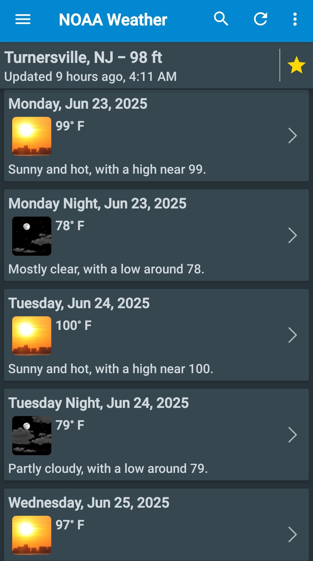
 10 hours ago, BBasile said:
Yes, I cant wait!!

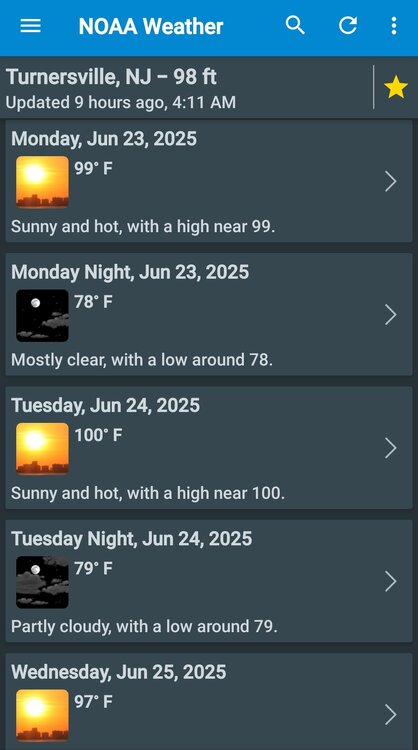
It's officially Go Birds season when we see this in the forecast.
-
1
-
-
-
10 minutes ago, LibertyBell said:
1881 Larry
No, 1877-78 was the super el nino. 1881 came off a weak el nino, and began a 3-year ENSO neutral period.
-
1
-
 1
1
-
-
13 minutes ago, LibertyBell said:
what about July 2010?
Some places were very warm, but it wasn't as widespread: https://www.ncei.noaa.gov/access/monitoring/climate-at-a-glance/statewide/mapping/110/tavg/201007/1/rank
In fact, 2011 was more widespread than 2010: https://www.ncei.noaa.gov/access/monitoring/climate-at-a-glance/statewide/mapping/110/tavg/201107/1/rank
-
1 hour ago, bluewave said:
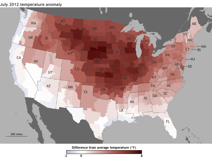
My comparison to how warm a summer departure for warmth would be if Detroit and the Great Lakes saw March 2012 or winter 2023-2024 occur in the summer was proportional and not the exact magnitudes of the departures. It’s what such a summer would look like in proportion to a peak above other recent summers. Since we know the range of the departures is generally greater during the cold season.
Didn't we get that in July 2012?
-
1
-
-
1 hour ago, LibertyBell said:
Yep February-April 2007 were really cold with the VD2007 storm, the St Paddys Day 2007 storm and the Tax Day Noreaster in April. The first three weeks of January 2007 (it hit 70) were warmer than the first three weeks of April 2007!
April 2007, in addition to being cold, was really wet. I think it was the wettest April on record at PHL. If only we had that wet pattern in February, we could have done some epic snow totals that month.
-
1
-
-
7 hours ago, LibertyBell said:
This isn't the same Chuck that we had in 2006-07 *warmest winter ever* LOL
November, December, and most of January was extremely warm. Temperatures really bottomed out in February 2007.
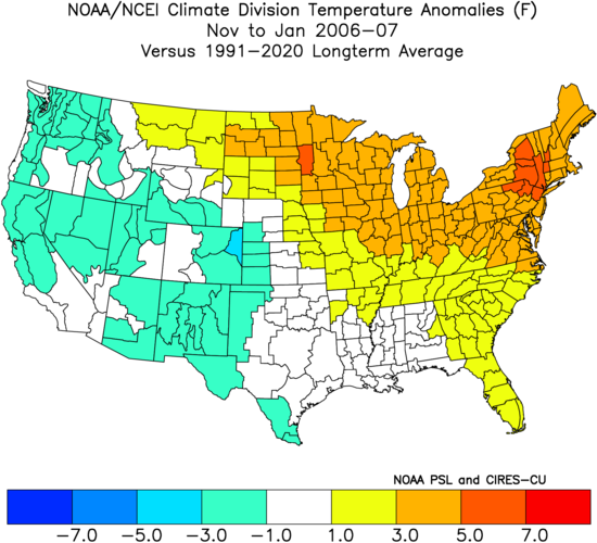
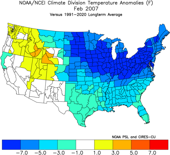
Aside from the historically cold February 2015, I believe February 2007 is the next coldest February this side of 1980.
-
1
-
-
29 minutes ago, LakePaste25 said:
Important to note that the 2021 ridge had some local geographic factors involved in addition to just the strength. There was a major downslope east wind event coming off of the Cascade mountains due to a surface low off the coast. For our region, the equivalent would probably be a downsloping west wind event that would send central park and EWR well beyond all-time record highs.
Is this what happened on 7/22/2011 when EWR got to 108?
-
1 hour ago, JTA66 said:
Yeah, looks like our luck is about to run out. Topped out at 64F yesterday, probably won't see that for a high again until mid October.

In 2023, when we last had highs in the mid-60s this late in June, we next had a high in the 60s on 9/23, which began a week of highs 70 or lower (although October started warm with several days in the 80s):
2023-09-23 63 58 60.5 -6.9 4 0 1.15 0.0 0 2023-09-24 70 63 66.5 -0.5 0 2 0.53 0.0 0 2023-09-25 66 58 62.0 -4.6 3 0 0.09 0.0 0 2023-09-26 63 58 60.5 -5.7 4 0 0.02 0.0 0 2023-09-27 70 55 62.5 -3.3 2 0 0.00 0.0 0 2023-09-28 65 56 60.5 -4.9 4 0 0.06 0.0 0 2023-09-29 68 59 63.5 -1.4 1 0 0.21 0.0 0 2023-10-01 81 60 70.5 6.4 0 6 0.00 0.0 0 2023-10-02 82 62 72.0 8.3 0 7 0.00 0.0 0 2023-10-03 82 59 70.5 7.2 0 6 0.00 0.0 0 2023-10-04 83 60 71.5 8.6 0 7 0.00 0.0 0 2023-10-05 81 58 69.5 7.0 0 5 0.00 0.0 0 2023-10-06 80 66 73.0 10.9 0 8 0.00 0.0 0 -
2 hours ago, snowman19 said:
The same repeating pattern year after year. Same background state. Different night, same endingHang in there. I'm sure we'll eventually get the background state that we got in late 2013 until the super el nino ended in early/mid-2016. The -PDO streak can't last the entire decade, right?
-
In the future, when we have cold waves in the middle of June, we'll always have June 21-22, 2023 and June 15-16, 2025 to compare it to.
-
1
-
-
27 minutes ago, LibertyBell said:
did we have a la nina state in the 44-55 period too?
Yeah, at least 1944-57 was a la nina state. (You could argue the la nina state lasted until 1976, although it was temporarily broken up during the strong el nino in 1957-58.)
-
1
-
-
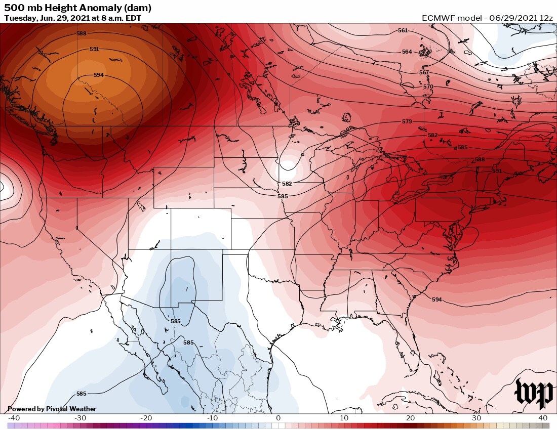
1 hour ago, bluewave said:
The La Nina background pattern will be in full effect next week. One of the strongest Southeast Ridges on record for late June in the forecast. Could even rival the ridge and heat experienced in late June 2021. I would take a repeat of January 2022 in a second if we can get the Pacific Jet to back off a bit in coming seasons. But the current WPAC warm pool is still running near record levels.
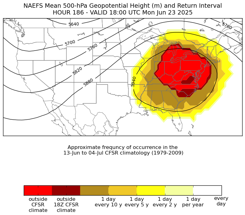

Wasn't this the one that produced the 120F (50C) temperatures in Western Canada at 50N latitude?
-
26 minutes ago, GaWx said:
I sincerely hope you’re right as I want a quiet season for a change. But “anyone that’s been paying attention knows we’re not coming anywhere these numbers”??Named Storms: 15-19
Total Hurricanes: 7-9
Major Hurricanes: 2-3
ACE Index: 120-150
Based on what are you saying you know we’ll be nowhere close to these mainly slightly above avg #s? We’re headed toward a weak Niña per RONI, which favors more active than avg and Atlantic temps are near the 1991-2020 avg, not cool?All the subtle changes. For one, the Pacific is already active this year. That was not the case last year. Secondly, we're entering a 2nd year without a clear ENSO state, and we're near a solar max. The last time we had those conditions were in 2013 and 2014, and both produced well below average seasons. (Quite a contrast to 2010-2012, which were 3 very active seasons.)
Everything is screaming this is going to be a quiet season. Here's my forecast (using 2013 and 2014 as my main analogs):
11 named storms (range 8-14)
4 hurricanes (range 2-6)
1 major hurricane (range 0-2)
51.5 ACE (range 36-67)
-
 1
1
-
-
4 minutes ago, GaWx said:
JB is actually calling for a not as active season as last year with ACE of 120-150, whose midpoint of 135 is only slightly above the ~122 avg of 1991-2020 along with only slightly above avg 7-9 H and near avg 2-3 MH:
Saffir-Simpson Hurricane Wind Scale Forecast
Named Storms: 15-19
Total Hurricanes: 7-9
Major Hurricanes: 2-3
ACE Index: 120-150Good luck with that. Anyone that's been paying attention knows we're not coming anywhere near these numbers.
-
 1
1
-
-
17 minutes ago, snowman19 said:
2013 was not very quiet and below average, it was exactly average. There were 14 named storms and 15 tropical depressions. 14 named storms is averageIt was only average in number of named storms. If you take a deeper look, 2013 finished with a Top 10 lowest ACE season, with only 2 hurricanes, and no major ones. (Even 2014 didn't go that low in those respects.)
2013 put up some numbers that seem unfathomable in this 21st century climate, especially coming off 3 very active seasons. It's a well-below average season.
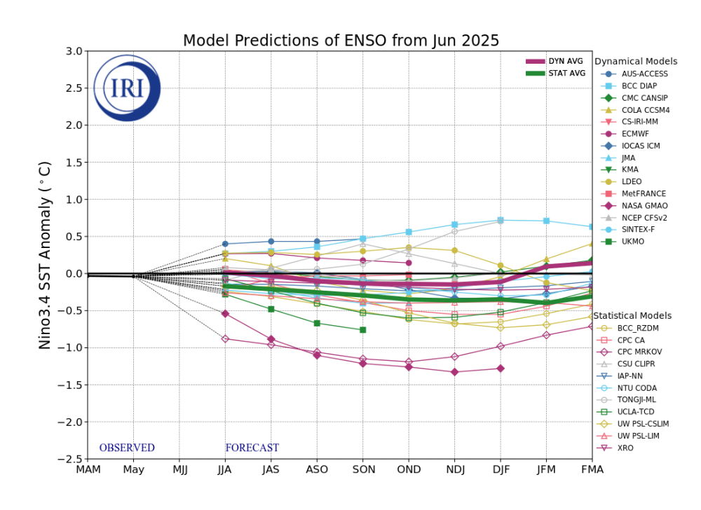
2025-2026 ENSO
in Weather Forecasting and Discussion
Posted
And it was only for a month. It needs to sustain +2.0 for multiple months to be considered a super el nino. That was only done in 1972-73, 1982-83, 1997-98, and 2015-16.
Plus, the RONI only reached +1.5 at its peak, which is not only significantly lower than the 4 super el nino years (all of the above years reached at least +2.25), but also lower than every strong el nino year (1957-58, 1965-66, 1986-88, 1991-92, and 2009-10).
Not to mention, the MEI was only a borderline weak/medium el nino. (Of the strong el nino years, only 2009-10 has a comparable MEI peak to 2023-24.)
2023-24 is a strong, but not super, el nino.