

PhiEaglesfan712
-
Posts
1,718 -
Joined
-
Last visited
Content Type
Profiles
Blogs
Forums
American Weather
Media Demo
Store
Gallery
Posts posted by PhiEaglesfan712
-
-
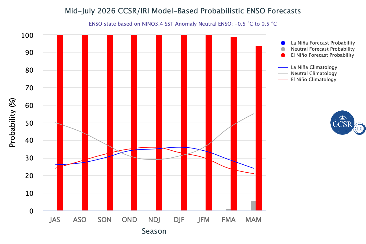
29 minutes ago, MJO812 said:
Many forecasts are for warmth but they are just going by enso. Many other factors to consider.
Yeah, I will always point out that the coldest winter CONUS in the 21st century was during a strong la nina. Strong/super el ninos generally mean warmth, but not always.
It's too early to tell whether this upcoming winter is going to be warm, but if the models are still showing a cold signal in September, then people need to accept that it will probably be colder (and possibly snowier) winter.
-
 1
1
-
-
1 hour ago, Psychguy said:
“Kissed” 90 (or maybe a peck on the cheek) at PHL today… 27th time this summer thus far. Last summer we were at 30 already, I believe.
But the summer just pretty much died after this point last year.
-
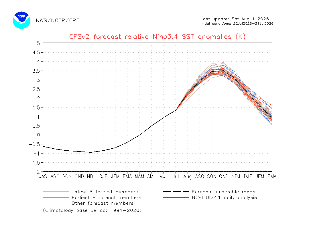
53 minutes ago, GaWx said:
CFS is at warmest yet!
Nov peak +3.75 vs record +2.69! Also, still has a record crazy rapid plunge Dec-Mar!
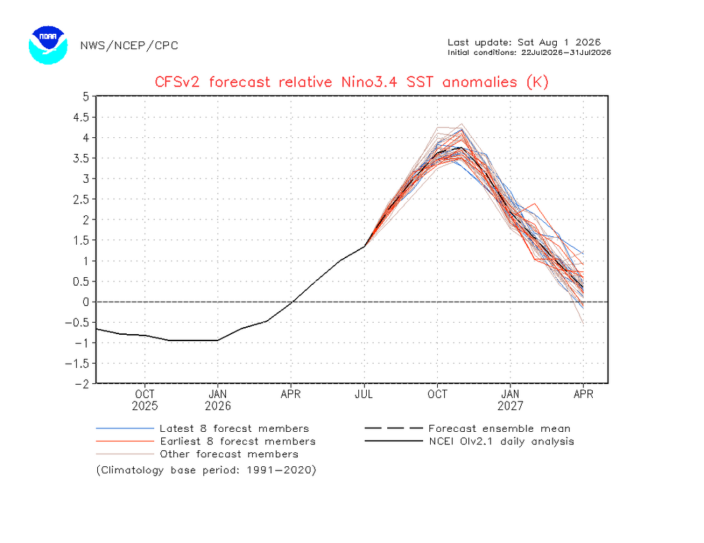
OND peak +3.5 vs record +2.52!
Yeah, that plunge looks like 1973, 1988, 1998, 2010 territory. All of those years resulted in a backlash, strong la nina.
-
 1
1
-
-
On 7/31/2026 at 7:16 AM, [email protected] said:
50/50 chance, more 90 degree days for Central Park the rest of this summer. It seems that 2004/2009 has arrived.
More like 2011 and 2013. Those were at least warm in the beginning before going absolutely cold in late July/early August.
2004 and 2009 were cold almost all the way throughout.
-
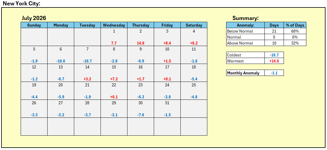
14 hours ago, donsutherland1 said:
July 2026 finished with a monthly mean temperature of 76.4°, which was 1.1° below normal (0.1° below the 1981-2010 baseline).
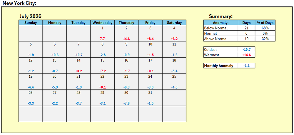

Almost like June, very warm first half of the month, not so much the 2nd half. I bet if you put the first half of June with the first half of July, it would be close to a record warm month, and if you put the 2nd half of June with the 2nd half of July, it would probably be a Top 10 coldest month.
-
4 hours ago, EasternLI said:
Looking at it this way, 97-98 and 87-88 stick out to me a little more so than the others. Again, not because of the actual readings compared to each other. Rather, the positioning of the warm pool biased east.
Interesting to note that each of these events were immediately followed by a strong la nina (1998-2000 and 88-89).
-
1
-
-
8 hours ago, Stormchaserchuck1 said:
People think Super Nino means warm too automatically. The NAO/AO play a role, and if you map N. Pacific 500mb anomalies historically with Super Nino's you will see a N. Pacific trough placement in the cold season where it is usually doesn't extend a 2nd wave ridge so far east.
People forget that our coldest winter CONUS in the 21st century happened during a strong el nino.
-
 1
1
-
-
3 hours ago, George001 said:
Imo the following winter is the one to watch for northern areas, not this upcoming one. I don’t see the roaring STJ dying off quickly especially if the El Niño lingers into the spring before collapsing into La Niña. When you combine the lingering STJ with a La Niña, big things can happen for northern areas. When it comes to sustained cold in an El Niño this powerful, I need to see it to believe it. Historical precedence for these super ninos is a warm east.
I can even see the el nino being so strong that it carries over into a 2nd year, but ending in fall 2027. This will give a head start to developing la nina, which peaks very strong in 2028-29, kind of like 1988-89. It will probably be a one-year la nina, but boy, will it be very strong.
-
10 minutes ago, Brian5671 said:
Typical convective nature of these summer events. Some areas that have gotten hit could make a run at 15-18 inches of rain this month
Almost like August/September 1999, which climaxed with Hurricane Floyd. It put paused to a long running drought. If not for that, knowing what came after, we would have had a near 5-year continuous drought.
-
2 hours ago, Psychguy said:
Today was "exactly normal" in Philadelphia... high 88 and a low of 70. How often does that actually happen? Normal high and low hit on the dot, so to speak.
It probably happens a lot more often. All I know is that there was no weathergami today.
-
In honor of LeBron going to the Sixers, let's change the lyrics of Will Smith's "Miami" to fit a more Philadelphia theme:
Uh, uh, yeah, yeah, yeah, yeah, uh
Philadelphia, uh, uh
Southeast Pennsylvania, bringin the Sixers , uh
Haha, can y'all feel that
Can y'all feel that
Jig it out, uh
Here I am in the place where I come let go
Philadelphia the bass and the sunset low
Everyday like a mardi gras, everybody party all day
No work all play, okay
So we sip a little something, lay to rest the spill
Me an Charlie at the bar runnin' up a high bill
Nothin' less than ill, when we dress to kill
Every time the ladies pass, they be like "hi Will"
Can y'all feel me, all ages and races
Real sweet faces
Every different nation, Spanish, Hatian, Indian, Jamaican
Black, White, Cuban, and Asian
I only came for two days of playing
But every time I come I always wind up stayin'
This the type of town I could spend a few days in
Philadelphia the city that keeps the roof blazin'
Party in the city where the Sixers are on
All night, on the beach 'til the break of dawn
"Welcome to Philadelphia"
"Bienvenidos a Philadelphia"
Bouncin' in the club where the Sixers are on
All night, on the beach 'til the break of dawn
I'm goin to Philadelphia
"Welcome to Philadelphia"
Yo I heard the rainstorms ain't nothin' to mess with
But I can't feel a drip on the strip, it's a trip
Ladies half-dressed, fully equipped
And they be screamin out, "Will we loved your last hit"
So I'm thinkin' I'ma scoot me somethin' hot
In this salsa-merengue melting pot
Hottest club in the city, and it's right on the beach
Temperature get to ya, it's about to reach
Five-hundred degrees in the Delaware Bay
With the hot mamis screaming "¡Ay papi!"
Everytime I come to town, they be spottin' me
In the drop Bentley, ain't no stoppin' me
So, cash in your dough and flow to this fashion show
Pound for pound anywhere you go
Yo, ain't no city in the world like this
An if you ask how I know I gots ta plead the fifth "Philadelphia"
Party in the city where the Sixers are on
All night, on the beach 'til the break of dawn
"Welcome to Philadelphia"
"Bienvenidos a Philadelphia"
Bouncin' in the club where the Sixers are on
All night, on the beach 'til the break of dawn
I'm goin to Philadelphia
"Welcome to Philadelphia"
Don't get me wrong, Chi-town got it goin' on
And New York is the city that we know don't sleep
And we all know that L.A. and Miami stay jiggy
But on the sneak, Philadelphia bringin' Sixers for real
Y'all don't understand
I never seen so many Dominican women with cinnimon tans
Mira, this is the plan
Take a walk on the beach, draw a heart in the sand
Gimmie your hand
Damn, you look sexy
Let's go to my yacht, in Rehoboth Beach
Ride my jetskis, loungin' in the palm trees
'Cause you gotta have cheese for the summerhouse piece on Southeast Pennsylvania
Water so clear, you can see to the bottom
Hundred-thousand dollar cars, e'ybody got 'em
Ain't no surprise in the club to see Sly, Stallone
Philadelphia, my fourth home
"Philadelphia"
Party in the city where the Sixers are on
All night, on the beach 'til the break of dawn
"Welcome to Philadelphia"
"Bienvenidos a Philadelphia"
Bouncin' in the club where the Sixers are on
All night, on the beach 'til the break of dawn
I'm goin' to Philadelphia
"Welcome to Philadelphia"
Party in the city where the Sixers are on
All night, on the beach 'til the break of dawn
"Welcome to Philadelphia"
"Bienvenidos a Philadelphia"
Bouncin' in the club where the Sixers are on
All night, on the beach 'til the break of dawn
I'm goin' to Philadelphia
"Welcome to Philadelphia"
Party in the city where the Sixers are on
-
6 hours ago, donsutherland1 said:
White Plains recorded its fourth consecutive low in the 50s. The last time that happened in July was during 2009. At that time, an El Niño was developing. Strong El Niño conditions are already present this year.
The real difference is that 2009 was near record cold throughout in June and July. This year has had wild temperature swings (since March). The first half of June was warm. The second half not so much. The first half of July was warm. The second half of July is going to be cold.
-
14 hours ago, 40/70 Benchmark said:
The AMO is pretty much the only aspect I didn't really touch on, though I supposed that isn't specifically connected to the polar domain, so that is probably best left for the actual outlook....but I do have that in the back of my head for colder risks. I def feel the correction vector for me is colder.
Didn't December 2018 have a mid Atlantic snowstorm? I remember it missed me, but I think it nailed VA.
I think it was January 2019:
2019-01-12 37 30 33.5 -3.8 31 0 0.13 1.9 0 2019-01-13 32 29 30.5 -6.7 34 0 0.71 8.3 4 2019-01-14 37 27 32.0 -5.2 33 0 T 0.1 10 -
1
-
-
6 hours ago, NorthWestNJ said:
I thought strong Nino summers generally have a cool second half and a more normal first half. Could be wrong though.
Not really. 2009 was cold throughout, with the exception of one week in August. 2015 was warm from July-September. 2023 was cold in June, but very warm in July and September.
-
I will go with colder than 94-95, but warmer than 09-10, for this upcoming winter. Depends on the PDO, though. If it stays deeply negative, it will end up closer to 94-95, but if it can go towards neutral, then it will end up closer to 09-10.
-
2 minutes ago, Mikeymac5306 said:
Kinda off topic but I saw Cecily Tynan post she has big personal news to announce at 6PM. Wonder if she is going to ABC News?
I think she's retiring.
-
2
-
-
47 minutes ago, bluewave said:If July ended today, it would tie with 1936 as the warmest July (and month) on record for the Contiguous U.S. Looking at the forecast for the rest of the month, I suspect we will not quite break the 1936 record.1:17 PM · Jul 22, 2026Map showing how many months so far in 2026 (Thru July 17th) each of the 385 "ThreadEx" stations have set or tied a monthly record high or low temperature record. So far, the totals are: 147 months with a new (set/tie) record high and 16 with a new (set/tie) record low (no duplicates).9:26 PM · Jul 18, 2026
I thought July 2012 broke the record for the warmest month. Or is that still in verification stage?
-
Barring a major volcanic eruption, like we had with Pinatubo in 1991, I'm almost certain next summer in most of the Eastern US is going to be record breaking hot. We may not see the high temps of 2011 or earlier this month, but the heat will be more consistent throughout like in 2010 and 2016 (both post-el nino summers).
-
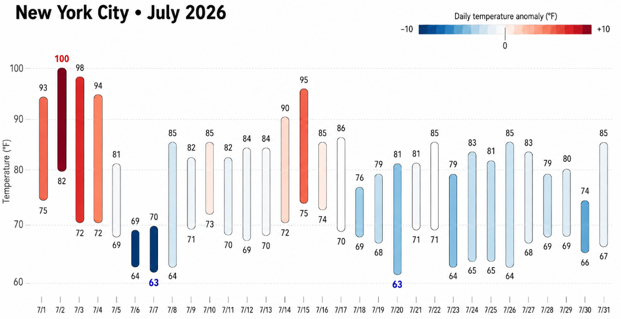
37 minutes ago, Psychguy said:
Wondering how many more 90 degree days we see… doesn’t look like any for the rest of the month. A 90 degree free August… wondering if Philly has ever had one… I’m sure they have, but not recently.
It actually happened in 2013:
2013-08-01 74 68 71.0 -7.4 0 6 1.33 0.0 0 2013-08-02 86 68 77.0 -1.3 0 12 0.00 0.0 0 2013-08-03 79 68 73.5 -4.8 0 9 T 0.0 0 2013-08-04 80 66 73.0 -5.2 0 8 0.00 0.0 0 2013-08-05 78 62 70.0 -8.1 0 5 0.00 0.0 0 2013-08-06 78 63 70.5 -7.5 0 6 T 0.0 0 2013-08-07 76 68 72.0 -5.9 0 7 0.06 0.0 0 2013-08-08 87 71 79.0 1.2 0 14 0.35 0.0 0 2013-08-09 88 76 82.0 4.2 0 17 T 0.0 0 2013-08-10 84 73 78.5 0.8 0 14 0.00 0.0 0 2013-08-11 85 66 75.5 -2.1 0 11 0.00 0.0 0 2013-08-12 86 72 79.0 1.5 0 14 0.00 0.0 0 2013-08-13 83 68 75.5 -1.9 0 11 2.02 0.0 0 2013-08-14 76 63 69.5 -7.8 0 5 0.00 0.0 0 2013-08-15 78 58 68.0 -9.1 0 3 0.00 0.0 0 2013-08-16 81 60 70.5 -6.5 0 6 0.00 0.0 0 2013-08-17 82 63 72.5 -4.4 0 8 0.00 0.0 0 2013-08-18 77 66 71.5 -5.3 0 7 0.03 0.0 0 2013-08-19 77 65 71.0 -5.7 0 6 0.00 0.0 0 2013-08-20 87 66 76.5 0.0 0 12 0.00 0.0 0 2013-08-21 89 70 79.5 3.1 0 15 0.00 0.0 0 2013-08-22 85 70 77.5 1.3 0 13 1.08 0.0 0 2013-08-23 77 68 72.5 -3.6 0 8 T 0.0 0 2013-08-24 82 65 73.5 -2.4 0 9 0.00 0.0 0 2013-08-25 81 61 71.0 -4.8 0 6 0.00 0.0 0 2013-08-26 86 65 75.5 -0.1 0 11 T 0.0 0 2013-08-27 89 73 81.0 5.6 0 16 0.00 0.0 0 2013-08-28 76 72 74.0 -1.2 0 9 1.04 0.0 0 2013-08-29 83 71 77.0 2.0 0 12 T 0.0 0 2013-08-30 83 69 76.0 1.2 0 11 T 0.0 0 2013-08-31 88 72 80.0 5.4 0 15 0.00 0.0 0 -
3
-
 1
1
-
-
15 years ago saw one of the most widespread heatwaves for this area. Newark set an all-time record of 108: https://www.wunderground.com/blog/JeffMasters/july-22-2011-a-day-of-records.html
-
9 minutes ago, GaWx said:
Good question. I don’t know but they’re both fascinating to see.
—————————
Aside: I’ve been having big problems today with inability to connect, lag, etc. This is similar to the problems of a few weeks ago. Anyone else having problems?Yeah, the connection has been spotty this morning.
-
1
-
 1
1
-
-
2 hours ago, 40/70 Benchmark said:
Guessing Feb 2015 was the one top-ten coldest.
I wish we would focus a bit more on temp maxes instead of mean because I feel like the nocturnal element does inflate the degree of impact somewhat. I don't really care if its 21 on RAD nights instead of 18....I care how warm it is during the day and when it's precipitating. Don't get me wrong....I know it's warming, I'm not trying to steal anyone's climate change, but it's warming the most on clear nights and the days/stormy nights are most relevant to us.
Yes, it was Feb 2015, but if something like that happened now, someone will be quick to point out that +10 temp departure in Las Vegas or somewhere out West.
-
 1
1
-
-
2 minutes ago, GaWx said:
Chris, I find it fascinating that the previous warmest was in August, another winter month! Do you know if that was also in El Niño?
Yes, I'm pretty sure the August spike was 2023, and likely the September spike as well. I remember there being an anomolous heatwave in South America in August 2023, and another one the following month.
-
1
-
-


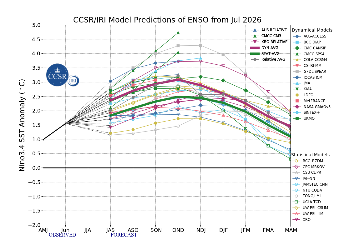
2026-2027 Super El Nino
in Weather Forecasting and Discussion
Posted
I'd say favored, but not a guarantee. There have been cold/snowy winters in robust el ninos. 2009-10 finishing as the coldest winter CONUS so far in the 21st century is one example. Also, 1957-58 was a historically cold and snowy winter in many places in the Eastern US.