

weathertree4u2
-
Posts
92 -
Joined
-
Last visited
Content Type
Profiles
Blogs
Forums
American Weather
Media Demo
Store
Gallery
Everything posted by weathertree4u2
-
February 2024 mid/ long range
weathertree4u2 replied to Holston_River_Rambler's topic in Tennessee Valley
Yea, looks like a good pattern after the middle of the month, seems like someone has been saying something about the middle of the month- 750 replies
-
- 5
-

-
- snow elk
- wooly worm
- (and 1 more)
-
February 2024 mid/ long range
weathertree4u2 replied to Holston_River_Rambler's topic in Tennessee Valley
There is a myriad of solutions, hopefully which ever variation actually happens will include some type of winter fun for the forum area. At least this time, it should be more typical of the forum area and not locked on the ground for ten days!- 750 replies
-
- 2
-
-
- snow elk
- wooly worm
- (and 1 more)
-
January Medium-Long Range Discussion
weathertree4u2 replied to Holston_River_Rambler's topic in Tennessee Valley
That is some crazy ice near Atlanta -
January Medium-Long Range Discussion
weathertree4u2 replied to Holston_River_Rambler's topic in Tennessee Valley
Food for thought, thanks for the post -
January Medium-Long Range Discussion
weathertree4u2 replied to Holston_River_Rambler's topic in Tennessee Valley
I need a break lol -
January Medium-Long Range Discussion
weathertree4u2 replied to Holston_River_Rambler's topic in Tennessee Valley
Not good is my initial guess -
January Medium-Long Range Discussion
weathertree4u2 replied to Holston_River_Rambler's topic in Tennessee Valley
I believe I got my seasonal total in one storm so I would be good if we broke warm the rest of the season honestly -
January Medium-Long Range Discussion
weathertree4u2 replied to Holston_River_Rambler's topic in Tennessee Valley
I cannot recall, but, were we getting the same indication three weeks ago for the current time period? -
Yea, we have a thin layer of snow on top of glaze on the roads and the front must have just come through here, the winds are howling out of the north now
-
We have gotten maybe a half inch but I am over the snow now lol
- 372 replies
-
- 1
-
-
- cold
- arctic blast
- (and 1 more)
-
January Medium-Long Range Discussion
weathertree4u2 replied to Holston_River_Rambler's topic in Tennessee Valley
I am in as long as we dont have snow on the ground for as many consecutive days as this go round -
I know I have a whole lot of weight on the roof with this snow pack and now the drizzly rainy stuff falling; I hope I can make it to next Monday without any of the gutters pulling off!
- 372 replies
-
- 1
-

-
- cold
- arctic blast
- (and 1 more)
-
January Medium-Long Range Discussion
weathertree4u2 replied to Holston_River_Rambler's topic in Tennessee Valley
Can I extrapolate from the discussion that we are saying that there is a chance we could do this all over again in February? -
Yea, I dropped to 3 now back up to 6; seems like all the NWS and local Mets know is reading models. I think my low was supposed to be 15
- 372 replies
-
- 1
-
-
- cold
- arctic blast
- (and 1 more)
-
000 FXUS64 KOHX 171951 AFDOHX Area Forecast Discussion National Weather Service Nashville TN 151 PM CST Wed Jan 17 2024 ...New SHORT TERM, LONG TERM... .SHORT TERM... (This afternoon through Thursday Night) Issued at 1256 PM CST Wed Jan 17 2024 Surface ridge is just now moving across Middle Tennessee, so we`ll start to pick up a stronger southerly flow soon, but temperatures still remain well below freezing despite a large warm-up from this morning`s lows. So tonight`s lows won`t be nearly as cold as last night`s, fortunately. Overnight, a developing surface system and upper trough are going to approach Middle Tennessee from the west. So we can expect more wintry weather tomorrow across most of Middle Tennessee. We have trimmed forecast highs for tomorrow (went with the 17Z CONSShort instead of the NBM). The NBM was giving us about a 22F warm-up, and that`s not going to happen given the expected precipitation (i.e., evaporative cooling) and the existing snowpack, even with a strengthening southerly flow. So freezing rain is likely to occur tomorrow over much of Middle Tennessee during the day, and into the evening along the Cumberland Plateau. Forecast soundings do point strongly to a freezing rain profile. While precipitation is expected to be light, even 0.01" of freezing rain is all we need to re-aggravate our travel difficulties. The greatest ice accumulations will occur along the Highland Rim and over to the Clarksville/Waverly areas, where accumulations of 0.05" to 0.07" are expected. Light snow accumulations are also possible in some areas, but not enough to meet advisory criteria. Thus, we are issuing a Winter Weather Advisory beginning at 18Z tomorrow for light ice accumulations and not for snow. The advisory will include most of Middle Tennessee west of I-65, Highland Rim & Cumberland Plateau. There are some areas that are being left out since not everyone will be cold enough to support ice accumulations. && .LONG TERM... (Friday through next Wednesday) Issued at 1256 PM CST Wed Jan 17 2024 The advisory will remain in place until 15Z Friday, mainly for lingering impacts. Another frigid air mass will work its way in behind tomorrow`s storm system, so that overnight lows will drop back into the single digits most areas Friday night and again Saturday night. Some locations will sneak above freezing on Sunday. Everyone else will have to wait until Monday. Next week looks to be significantly warmer than this week, thank goodness.
- 372 replies
-
- 3
-
-

-
- cold
- arctic blast
- (and 1 more)
-
Same my general forecast low across models was 5 above. I beat that by 6, but neighbors further away from the water beat it by 10 or more degrees. It requires a smarter mind than mine but it is strange to me how algorithms have not been developed to handle this better. I knew we were going negative yesterday afternoon when it dropped from 12 @ 530 down to 3 or 4 by 7
- 372 replies
-
- 2
-
-
- cold
- arctic blast
- (and 1 more)
-
I know they are not handling it well in my area; I was down to -9.8; forecast low was 5, so far, I am up to 14.5
- 372 replies
-
- 4
-
-
- cold
- arctic blast
- (and 1 more)
-
January 15th-17th 2024 Arctic Blast/Snow Event
weathertree4u2 replied to John1122's topic in Tennessee Valley
We are still going down, right now down to -9.9 coldest I have recorded been here since April 1997; as a kid I can recall the record cold of 1985 where Nashville bottomed out @ -17 a record that still stands to this day -
January 15th-17th 2024 Arctic Blast/Snow Event
weathertree4u2 replied to John1122's topic in Tennessee Valley
Sumner county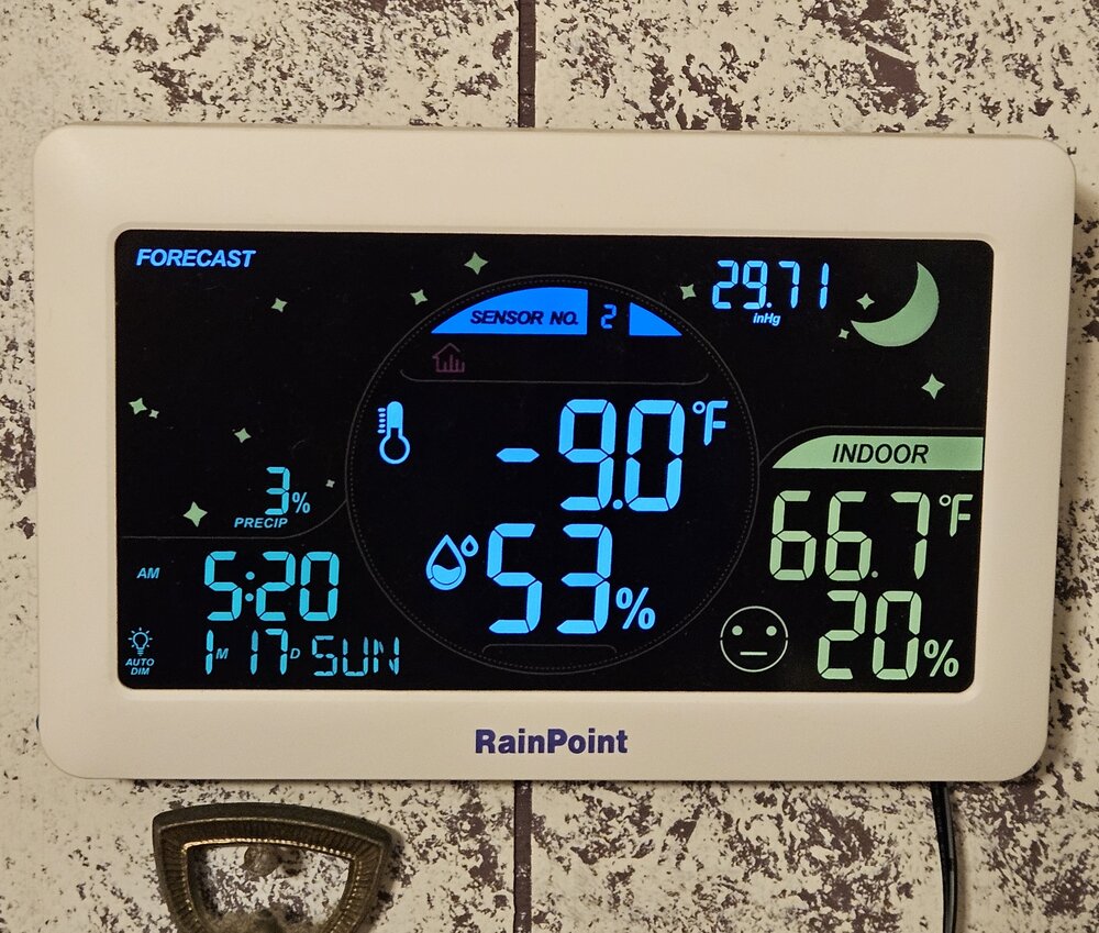
-
January 15th-17th 2024 Arctic Blast/Snow Event
weathertree4u2 replied to John1122's topic in Tennessee Valley
-8 here -
January 15th-17th 2024 Arctic Blast/Snow Event
weathertree4u2 replied to John1122's topic in Tennessee Valley
I am -4 north of Nashville with 7" of snow -
I am at -4 now with 7" on the ground
-
So we are still counting on a "half-time" next week right? I need a minute to try to find some more firewood, which should be fun!
- 372 replies
-
- 2
-
-
- cold
- arctic blast
- (and 1 more)
-
OHX Morning Discussion... 000 FXUS64 KOHX 161218 AFDOHX Area Forecast Discussion National Weather Service Nashville TN 618 AM CST Tue Jan 16 2024 ...New AVIATION... .SHORT TERM... (Today through Thursday) Issued at 231 AM CST Tue Jan 16 2024 The mid state now has a legitimate snow pack and this will need to be taken into account in terms of dealing with our upcoming temp fcst. Looks like 4-8 inches of snow depth is rather common place area wide. For now though its a very cold morning with current temps holding in the 10-15 degree range. Clouds are still in place but we will get some clearing by afternoon from nw to se. It`s not going to warm up much however as we have two things working against it. For one, the snowpack will of course act to reflect much of the afternoon solar radiation that we finally start to get. Secondly, strong thermal troughing will be building our way with those 850 mb temps dropping toward -15C by this afternoon. So, will undercut the NBS numbers by a few degrees. Looks like highs today will reach just the 14F to 19F range. Looks like a bone chilling cold night ahead. By Wednesday morning the sfc high will reach MS with ridging extending northeastward. Clear skies and the snow pack will help send our temperatures down to close to zero for many locations. Following this, the Wed afternoon temperatures will finally warm back up into the 20s. For the wind chill advisory, latest apparent t grids suggest that the advisory shall continue. It will therefore remain in effect until 9am Wednesday morning. Though winds will be on the lighter side, the temperatures themselves will be cold enough to produce some negative wind chill values. This is due to the 8-10 mph winds that are expected at times. Moving on, another storm system will take shape near the Arklatex region late Wednesday night. The sfc low will stay to our south and there is some n-s inversion with the system. Hence, there will be some waa trying to kick in on Wednesday and into Wednesday night. However, when taking into account the expected wet bulbs at a variety of levels, the recovery looks a touch overdone by the models. That said, for now, it appears that this next system will be mostly snow north and rain and snow south. We could also experience some IP activity across the south as well but for now will avoid the inclusion. The system right now does not appear to be all that strong but some light snow accumulations cannot be ruled out. Perhaps an inch or so of snow will be possible Thursday into Thursday night, mainly north and Plateau. && .LONG TERM... (Thursday Night through next Tuesday) Issued at 231 AM CST Tue Jan 16 2024 In the extended forecast, another arctic front will be on the heels of the Thursday system. Lows by Friday morning will be back down to near 20 for many areas with just a small warmup during the day. Adding to the chill will be some light snowfall that could continue into the day. The rest of the extended looks dry but very cold. Look for single digits for lows into the weekend with moderating temps and highs near 40F by Monday. && .AVIATION... (12Z TAFS) Issued at 618 AM CST Tue Jan 16 2024 Light snow showers should end SRB/CSV by 16/14Z-16/15z. Initial IFR/MVFR ceilings SRB/CSV will become exclusive MVFR after thru 17/00Z. Initial VFR ceilings will continue to prevail CKV/BNA/MQY with gradual ceiling degradation CKV to MQY 16/23Z-17/01Z. Errosion of ceilings at all terminals should occur no later than 17/03Z as high pressure influences surface and aloft strengthen across our area. Initial sfc sustained NW winds around 10kts should slowly back to S as 17/12Z approaches. && .PRELIMINARY POINT TEMPS/POPS... Nashville 18 2 28 15 / 0 0 0 0 Clarksville 16 4 28 15 / 0 0 0 0 Crossville 15 -2 25 12 / 0 0 0 0 Columbia 18 -1 27 13 / 0 0 0 0 Cookeville 15 -2 24 13 / 0 0 0 0 Jamestown 15 -2 25 12 / 0 0 0 0 Lawrenceburg 17 -1 26 13 / 0 0 0 0 Murfreesboro 17 -2 27 12 / 0 0 0 0 Waverly 17 2 28 15 / 0 0 0 0 && .OHX WATCHES/WARNINGS/ADVISORIES... Wind Chill Advisory until 10 AM CST Wednesday for Bedford-Cannon- Cheatham-Clay-Coffee-Cumberland-Davidson-De Kalb-Dickson- Fentress-Giles-Grundy-Hickman-Houston-Humphreys-Jackson-Lawrence- Lewis-Macon-Marshall-Maury-Montgomery-Overton-Perry-Pickett- Putnam-Robertson-Rutherford-Smith-Stewart-Sumner-Trousdale-Van Buren-Warren-Wayne-White-Williamson-Wilson. && $$ SHORT TERM...21 LONG TERM....21 AVIATION.....JB Wright
-
January Medium-Long Range Discussion
weathertree4u2 replied to Holston_River_Rambler's topic in Tennessee Valley
Will be needing a break by then. Even the winters we look back on as great were not continuously cold and snowy
