
Maggie Valley Steve
-
Posts
866 -
Joined
-
Last visited
Content Type
Profiles
Blogs
Forums
American Weather
Media Demo
Store
Gallery
Everything posted by Maggie Valley Steve
-

2023-2024 Fall/Winter Mountain Thread
Maggie Valley Steve replied to The Alchemist's topic in Southeastern States
GSP is a bit more bullish this morning regarding snow chances with the very dynamic clipper system. A dusting to an inch or two for those above 3500 ft with the highest totals near 4 inches across the Smokies. Interesting to read GSP mentioning low topped thunderstorms and small hail possible outside the Mountains. Maybe some thundersnow? Could be a non zero chance. -
2023-2024 Fall/Winter Mountain Thread
Maggie Valley Steve replied to The Alchemist's topic in Southeastern States
The good news is the Ski Areas are doing much better than last year. Cataloochee has been making snow throughout this week and with additional snow on the way for the weekend, we will not see them closing as February ends like last year! -
2023-2024 Fall/Winter Mountain Thread
Maggie Valley Steve replied to The Alchemist's topic in Southeastern States
22 this morning in the Valley. -
2023-2024 Fall/Winter Mountain Thread
Maggie Valley Steve replied to The Alchemist's topic in Southeastern States
Nothing at the Valley floor, but flurries are still flying above 4500 ft. -
2023-2024 Fall/Winter Mountain Thread
Maggie Valley Steve replied to The Alchemist's topic in Southeastern States
I've been watching the GFS slowly but steadily trending South with our Friday night/Saturday morning clipper system. It will be interesting to see if this trend continues. -
2023-2024 Fall/Winter Mountain Thread
Maggie Valley Steve replied to The Alchemist's topic in Southeastern States
30 for my low this morning and the snow guns were blowing this morning at Cataloochee! -
2023-2024 Fall/Winter Mountain Thread
Maggie Valley Steve replied to The Alchemist's topic in Southeastern States
Well, the predicted heavy rainfall has failed to materialize so far and the NWFS is looking light, but freezing temperatures look to return which will help in snow making this week. I like our chances for the possibility of overrunning ahead of the Saturday storm with a bit more robust NWFS to follow. Temperatures this weekend look cold with highs struggling to reach 30 and night lows in the low 20’s. Looking like a good Presidents Day Weekend for skiers! Enough of the doom and gloom. Time for some positives for the Mountains! -
2023-2024 Fall/Winter Mountain Thread
Maggie Valley Steve replied to The Alchemist's topic in Southeastern States
Looks like the string of gorgeous weather is coming to an end. Clouds have rolled in and rainy and potentially stormy weekend into early next week is ahead. I see that there is a NWFS possibility early next week as well. I am definitely seeing signs of a significant pattern change coming next week. Hopefully the ski areas survive the upcoming heavy rainfall. I know Cataloochee has taken advantage of the nightly below freezing temperatures the past 7 days a made a lot of snow. -
2023-2024 Fall/Winter Mountain Thread
Maggie Valley Steve replied to The Alchemist's topic in Southeastern States
Congrats Timm. You live in the NC Snow Capitol! Back in my younger days in college I enjoyed what the old Wolf Laurel could deliver! Great memories! -
2023-2024 Fall/Winter Mountain Thread
Maggie Valley Steve replied to The Alchemist's topic in Southeastern States
Down to 40 now. I'm certainly not expecting anything more than a mix at best here at 3300 ft, but I am impressed how quickly the moisture moved in and actually overcame a very dry layer this afternoon. Maybe I'll be surprised in the morning. -
2023-2024 Fall/Winter Mountain Thread
Maggie Valley Steve replied to The Alchemist's topic in Southeastern States
Currently 44. Dropped from 50 at 4PM. Light rain here now, but it's definitely at least a snow/rain mix above 4500 ft. Can't see Sheepback Mountain now and the top of Buck is mostly obscured. -
2023-2024 Fall/Winter Mountain Thread
Maggie Valley Steve replied to The Alchemist's topic in Southeastern States
Light snow has started at Cataloochee. I actually had a brief sleet shower a bit ago at the house. -
2023-2024 Fall/Winter Mountain Thread
Maggie Valley Steve replied to The Alchemist's topic in Southeastern States
Good grief! 2 Feet of snow + for Haywood County early next week. -
2023-2024 Fall/Winter Mountain Thread
Maggie Valley Steve replied to The Alchemist's topic in Southeastern States
Finally flipped to all snow. Still above freezing though. -
2023-2024 Fall/Winter Mountain Thread
Maggie Valley Steve replied to The Alchemist's topic in Southeastern States
Light rain/snow mix in Maggie. -
2023-2024 Fall/Winter Mountain Thread
Maggie Valley Steve replied to The Alchemist's topic in Southeastern States
Snowing at Cataloochee. Winds were howling earlier and temperature is down to 36. -
2023-2024 Fall/Winter Mountain Thread
Maggie Valley Steve replied to The Alchemist's topic in Southeastern States
GSP going big for the Smokies... URGENT - WINTER WEATHER MESSAGE National Weather Service Greenville-Spartanburg SC 333 PM EST Sat Jan 27 2024 NCZ051-052-280445- /O.NEW.KGSP.WS.W.0003.240128T1700Z-240129T1700Z/ Swain-Haywood- 333 PM EST Sat Jan 27 2024 ...WINTER STORM WARNING IN EFFECT FROM NOON SUNDAY TO NOON EST MONDAY ABOVE 3500 FEET... * WHAT...Heavy mixed precipitation expected. Total snow accumulations of 2 to 6 inches at elevations of 3500 to 4500 feet, and 6 to 9 inches above 4500 feet. Winds will gust 40 to 50 mph. * WHERE...High elevations of Swain and Haywood Counties, above 3500 feet. * WHEN...From noon Sunday to noon EST Monday. * IMPACTS...Travel could be very difficult. The hazardous conditions could impact the morning commute. Gusty winds could bring down tree branches. -
2023-2024 Fall/Winter Mountain Thread
Maggie Valley Steve replied to The Alchemist's topic in Southeastern States
62 here and I'm wearing shorts and flip flops! -
2023-2024 Fall/Winter Mountain Thread
Maggie Valley Steve replied to The Alchemist's topic in Southeastern States
Temperature finally warmed up to the mid 50's! That gave me the chance to take down exterior Christmas lights, clean up the 2200 Sq feet of decks we have around the house pick up a bunch of downed limbs for the firepit. It is sure looking like we may get some NWFS Sunday into Monday. So a 5 day break and it's back to winter. There is still a lot of snow on the mountains above 4K. -
2023-2024 Fall/Winter Mountain Thread
Maggie Valley Steve replied to The Alchemist's topic in Southeastern States
0 in Maggie Valley this morning. I'm ready for the warmup now. A thaw will be nice until the bottom falls out again in about a week or so. -
2023-2024 Fall/Winter Mountain Thread
Maggie Valley Steve replied to The Alchemist's topic in Southeastern States
Already down to 13 with clear skies and no wind. -
2023-2024 Fall/Winter Mountain Thread
Maggie Valley Steve replied to The Alchemist's topic in Southeastern States
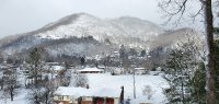
A couple of pics -
2023-2024 Fall/Winter Mountain Thread
Maggie Valley Steve replied to The Alchemist's topic in Southeastern States
Down to 21 and snow stopped completely a couple of hours ago. Looks like I'm done for this event. Time to hibernate and frankly looking forward to the break coming next week! -
2023-2024 Fall/Winter Mountain Thread
Maggie Valley Steve replied to The Alchemist's topic in Southeastern States
First slow down all day here at the house! That looks beautiful Met. Hopefully I can get under another long fetch band this evening! -
2023-2024 Fall/Winter Mountain Thread
Maggie Valley Steve replied to The Alchemist's topic in Southeastern States
Flakes are a good mix of quarter, nickel and dimes and coming down nicely now. Congrats to the Asheville area crew and everyone else getting in on the action!
