

Witness Protection Program
-
Posts
594 -
Joined
Content Type
Profiles
Blogs
Forums
American Weather
Media Demo
Store
Gallery
Posts posted by Witness Protection Program
-
-
^^^^ No.
And the storm southwest of Houston just got a tornado warning.
Headed east towards W. Columbia.
https://forecast.weather.gov/wwamap/wwatxtget.php?cwa=hgx&wwa=tornado warning
-
33 minutes ago, CryHavoc said:
Tornado warning for just south of Natchitoches, LA.
30 minutes ago, Derek30 said:Original Nacogdoches storm tornado warned now
The ol' Nacogdoches/Natchitoches conundrum. One, the other, or both?
-
5 hours ago, yoda said:
At 605 AM EDT, a confirmed large and extremely dangerous tornado was
located near Bamberg
Town name checks out.
-
Looks like it passed north of Clemson Univ? Though of course the campus is closed because of the Wuhan Flu.
-
5 current tor warns along the line from SC to FL.
-
-
6 minutes ago, Chinook said:
So this is the 2nd or 3rd or 4th tornado to climb the Appalachians today? Sounds like April 3-4th 1974, when a tornado went over a mountain in West Virginia.
This appears to be running up the valley.
-
8 minutes ago, Indystorm said:
What is it about Yazoo City MS and Moore OK?
Well it's in the right vicinity.
And maybe Bly Bio Chem is a magnet.
-
Tor warning for Whitehouse & Kilgore, southeast of Tippecanoe & Tyler, too.
https://forecast.weather.gov/wwamap/wwatxtget.php?cwa=fwd&wwa=tornado warning
-
-
Storm east of Del Rio has a tor warn near Bracketville.
-
The new(?) NWS San Angelo radar format is...not good. Unless you live right on an interstate, it is almost impossible to find your exact location on a map. That's a pretty big safety downgrade.
https://www.weather.gov/sjt/NationalRadar2
Perhaps I'm missing it, but I can't find an option to turn on a map layer with more detail, such as the topo most other NWS radars have. Just two levels of zoom, previously you could zoom into to a very detailed layer of roads and often even buildings. The new format does have less clutter for the storms, but...
There's also an annoying autostart voice message on their homepage. Luckily if you click the radar link in the top row of text you can navigate to the old format radars. But a lot of non-weather geeks are going to go to that page only in a severe threat and could easily miss that.
Speaking of NWS San Angelo, is the excellent former TWC met, Dr. Steve Lyons, still in charge there?
-
Good: The Weather Channel is doing follow up coverage of the TN tornadoes.
Bad: Can anyone watch for very long? That shameless drama queen Justin Whatever is horrible. LOL, a lady picking up bricks kinda turned and looked at him like she wanted to hit him with one as he stood there endlessly babbling cornball cliches while she's trying to clean up. Was like a Geico commercial.
-
 1
1
-
-
11 minutes ago, Bob's Burgers said:
Everybody should watch this
Starting 14:55 into the video, that's probably EF4 damage, right? Home after home blown down to their foundation.
-
Um, multiple tornado warnings between Huntsville and Chattanooga.
-
And in SW MO, outside of the tornado watch:
https://forecast.weather.gov/wwamap/wwatxtget.php?cwa=tsa&wwa=tornado warning
...A TORNADO WARNING REMAINS IN EFFECT UNTIL 630 PM CST FOR
SOUTHEASTERN NEWTON...NORTHEASTERN MCDONALD AND WEST CENTRAL BARRY
COUNTIES...
-
It kind of looks like there's a 2nd line of storms forming from Longview to east of San Antonio. I know they are separate Meso discussions, but some of the small popups in between seem along a line.
-
I see on Ms. Twitter that iMr.Cyclone made it through ok. Still has to survive the cannibalism, though.
Edit: Removed the link, it seemed to be circular rumors. So maybe not ok. Or just ok. Which nowadays I hear is not ok. -
So still no word from Hurricane Mr. Morgerman?
-
Now MASH Harbour. Cat 4 & 5's scare the heck out of me.
-
1 hour ago, JakkelWx said:
Cmon guys. Really? SW Wobble. Yes, SW wobble. You heard it right. SW wobble! We talkin' bout SW wobbles. How many SW wobbles will it take to will this thing to Australia?
The Weebles model has been the best performer today. Lots of wobbles but it doesn't fall down.
-
 1
1
-
1
-
-
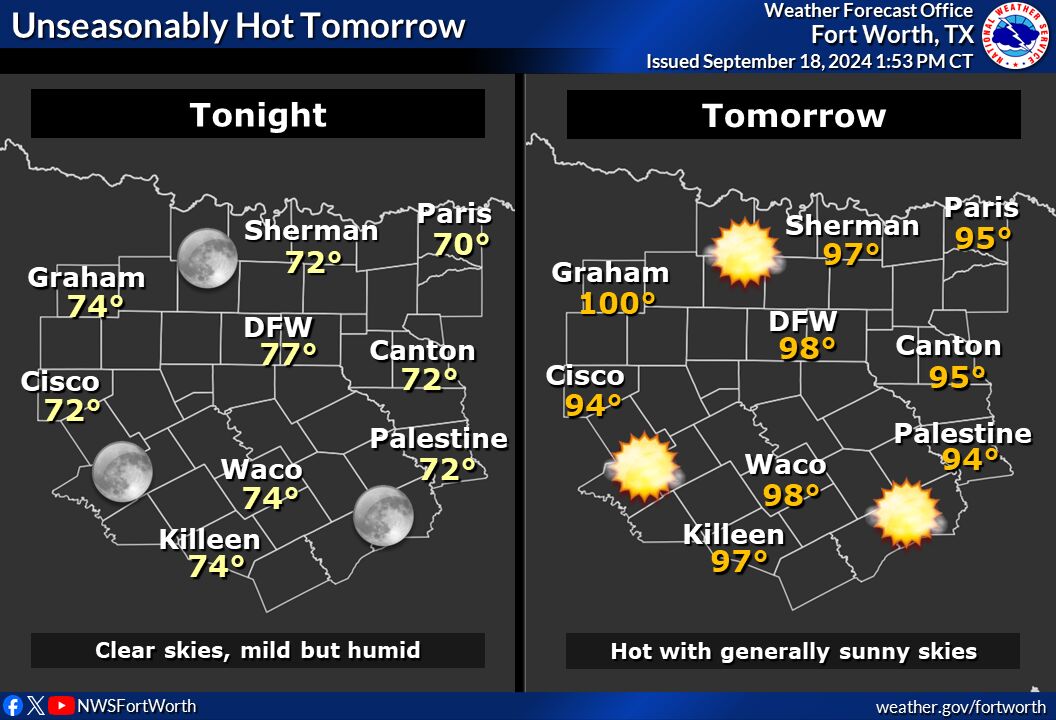
https://www.weather.gov/images/fwd/graphicast/image_full1.jpg?7ba82bb19e61c89a8f97eadc28a28d02
"Mostly dry weather is expected, which is why this week was chosen."
It has stormed every day of this planned radar outage, with some big ones today.
Another awesome job of forecasting.
-
New MD:
https://www.spc.noaa.gov/products/md/md1113.html
And Severe Watch replaces the Tor Watches:
https://www.spc.noaa.gov/products/watch/ww0297.html
-
You get any damage? That line that just crossed US27 looks pretty nasty, too.
April 19th Severe Event
in Southeastern States
Posted
About to pulverize Purvis.