.jpg.60032c348ffbfe96450212c98c077602.jpg)
vortexse93
-
Posts
93 -
Joined
-
Last visited
Content Type
Profiles
Blogs
Forums
American Weather
Media Demo
Store
Gallery
Everything posted by vortexse93
-
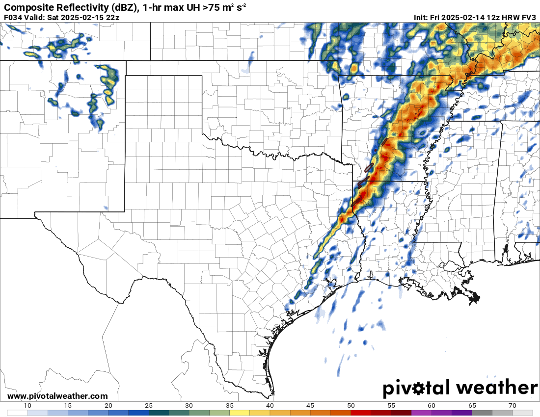
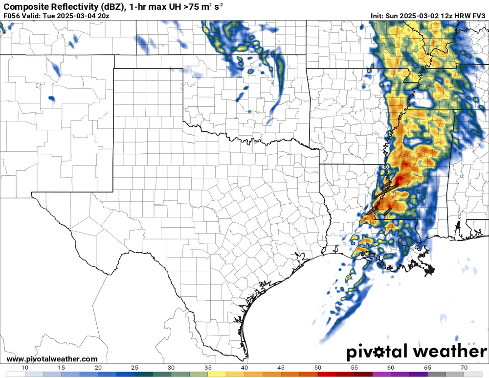
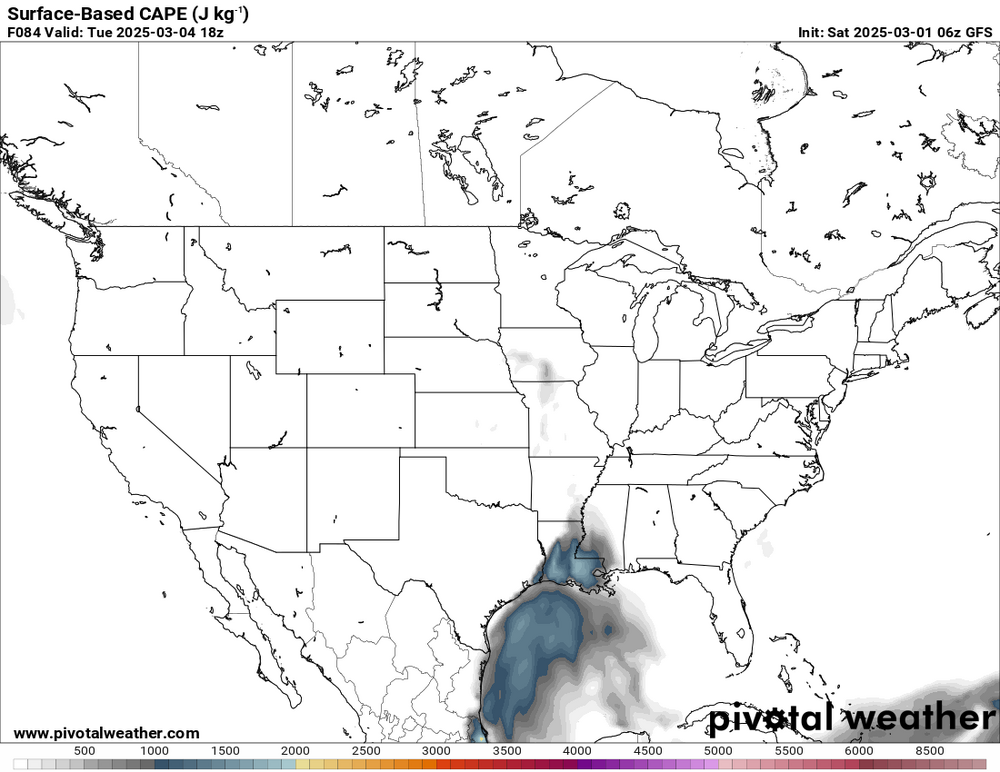
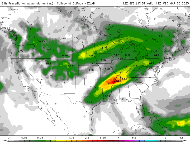
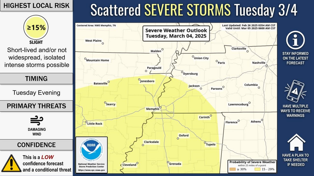
This is the first look at any of the higher resolution models and kinda of impressed that the HRW-FV3 not being supercell heavy as it usually is. It also follows the trends of the EURO, GFS and NAM where the best instability will be at for Tuesday. If supercells were to develop, it would not shock me to see them in Louisiana into southern Mississippi. For rest of Central Mississippi, still expecting damaging winds to be the main concern with potential for embedded tornadoes in the line. However, it will be solely dependent on if instability will be present across Central Mississippi for storms to be tornadic. There is plenty of forcing present, but you still need fuel. Chasing to looks to be a no go at this time and I think I will wait for the next system.
-
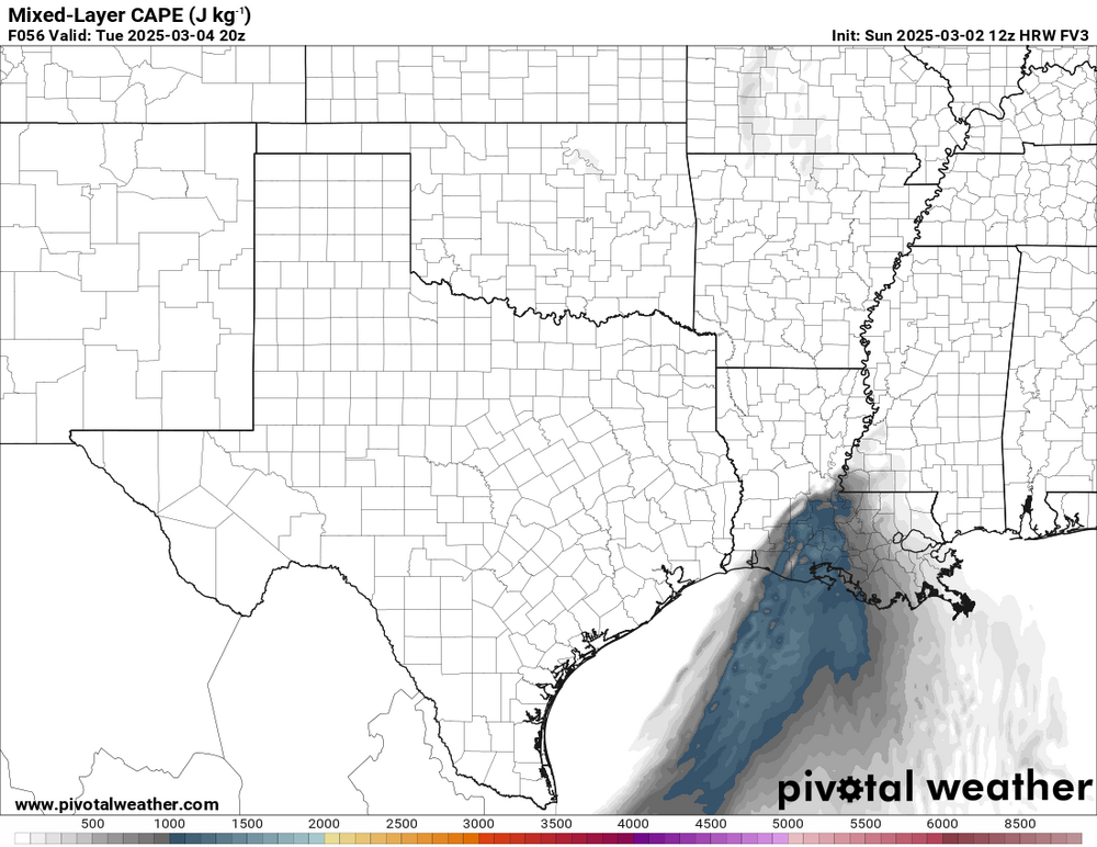
I never trust the NAM lol. In seriousness, I’m not liking this setup one bit. On paper yes, this has the potential for QLCS tornado event, but the struggling CAPE has me concerned especially as someone who is thinking about chasing. I just think this will be more of a damaging wind threat vs a tornado threat. Also, i think the 60-70 knt low level jet will either force storm merger to occur faster leaving limited time for storms to remain discrete and/or will cause storms to be highway speed so chasing becomes very difficult. Could the low level jet help overcome the weak/struggling CAPE, yes, but is that something I am willing to bet on as a chaser, no.
-
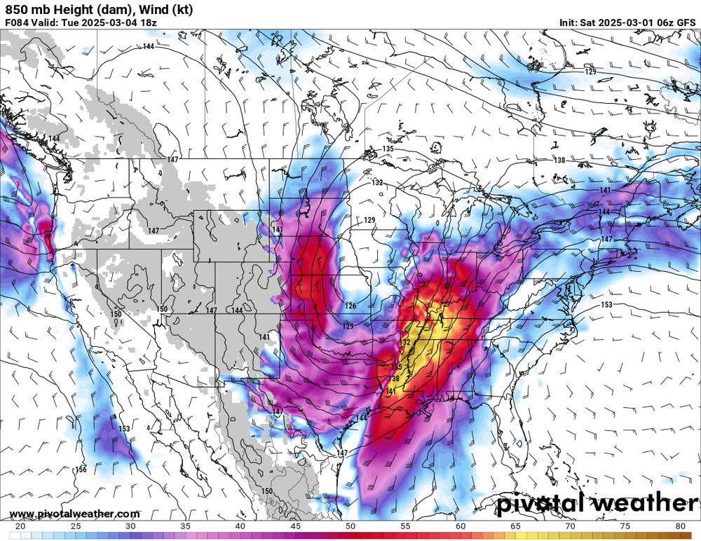
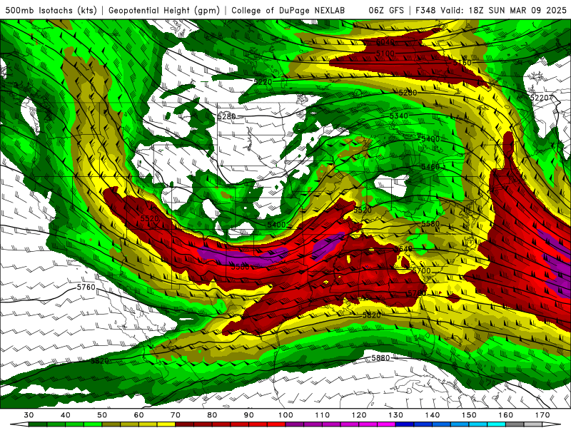
My discussion for regarding Tuesday Severe WX: This appears to be a QLCS driven event from the start. Most of the long to medium range models appear to be in agreement with storm mode and track with this system. However, there is some differences on the timing and how far north the instability will advect northward. Just by glancing through the model data this morning and from what I have gather through the CIPS Analog (last day to reference CIPS Analog for me at this point) nothing screams tornado outbreak at this time. Also it is worth noting that the current CIPS Analog does not have a good match for this when compared to the model guidance (this could change). With that said, this is appearing to be a system not worth chasing IMO only. Low-level jet of 60 to 70 knots from all the model guidance screams linear storms and fast moving storms. Secondly, instability will struggle to advect northward throughout the day, which leads to how much energy will be present at the time. Another issue is that the positioning of the Low. It will be well to the north which does not help with directional shear (speed shear will most be there no doubt). Also, the overall environment is not supportive for supercell storms out ahead of the main line. So for me, as a storm chaser, this is appearing to be more of a no go at this time. This subject to change as we get closer into time but time will tell.
-
12z data does a complete flop from yesterday. There goes my forecast discussions and CIPS Analog analysis for the week. If you don’t mind, I might be in the corner crying lol.
-
Decided to do some digging into the CIPS Analog and found a rough match to what the models are signaling for early next week. Given the similarities between the CIPS match and the current model guidance, it would not be all that surprising to see a similar setup where the focus will be mainly wind along with flooding. With how the the model guidance been trending, early next week is looking more like a QLCS event more so than a supercell event with the environment favoring a high shear - low CAPE environment. While it is way to early to o get into the heavy details for next week, it would not shock me to expect the tornado threat to be more of a secondary issue at this moment. I am not saying the system won't or it will over-achieve; I am saying the model data and the analog does not support a big tornado threat at this time. Also, when systems tend to be QLCS dominant from the start, the environment seems to struggle in being tornado producers (this is based on my experiences and observations). When also comparing to the analog, it also seems to support that next week could very be more of a damaging wind and flood threat over a tornado threat. Time will tell and expect model data to change between now and then. I just thought it would be interesting to at least share and compare what model guidance is showing vs the CIPS Analog had picked out while I had the time.

-
I have noticed that also but my two big rules I have for chasing are: 1). Do not chase at night ever. 2). Don’t chase through the woods and over the hills to grandmother’s house we go or in the case in Dixie Alley lol. I just have to see and wait to see how things play out next week before making any decisions on chasing.
-
Have not looked in great detail for early next week but will continue to monitor this setup for the next several days. Not surprised to see an early March setup given how unusually warm we have been this week so far in this region. As others have already mentioned, this system could be more of a QLCS type event. If that’s the case, might just sit this one out or possibly go get lightning pictures off the reservoir Tuesday night. Only time will tell.
-
No QLCS, I need sups to chase lol
-
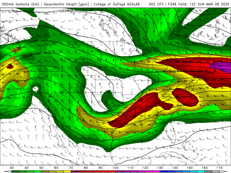
It appears the GFS is trying to hold onto the quick little shortwave instead of it developing into a more long wave trough. The 12z GFS ensemble is also to be trying to do the same. Interesting that the GFS is the only showing this type of solution. Given the current timing, chasing could be difficult since we will be in early spring and night time chasing is not my cup of tea. Meanwhile, I’m still waiting for the 12z CFS to see what mid-March is still showing.
-
I guess we can’t forget to watch for system as model guidance going into early March. While it was not on my initial radar (no pun intended), it is something to consider in potentially chasing, especially if the EURO model is right. The GFS shows a quicker and more northerly path while the EURO has a slower and more southerly path. If this counts for anything, the EURO-AI is also favoring a the southerly track. As for the GFS and EURO ensembles, they both show a similar trajectory to that of the EURO with the GFS ensemble splitting the difference more or less between the EURO data and the GFS data. As @nrgjeffsays, “Chase early and often will be the memo this year.”


-
I did noticed 6z GFS and the CFS run (in my post) did have a similar pattern which is one of the positives I did note along with the quick warm up right after the cold shot of air. To be truthful, I do like the mid-March setup but it also has its own pitfalls which prevents me from getting overly excited about if that makes sense. I tend not to over hype but there is a signal there for sure.
-
I think for me, it’s the cold shot of air that long models are indicating could be what messes everything up leading into mid-March more so than the NAO phase. Any cold shot of air will just ruin any hopes of a mid March severe weather potential. Now after mid-March, it is more a wait and see type deal.
-
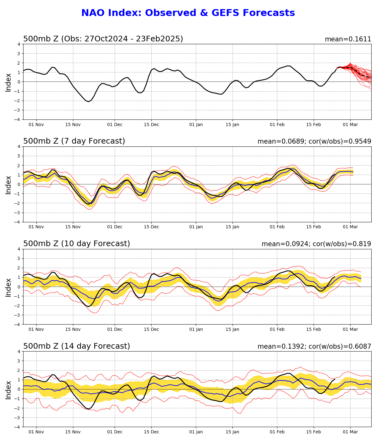
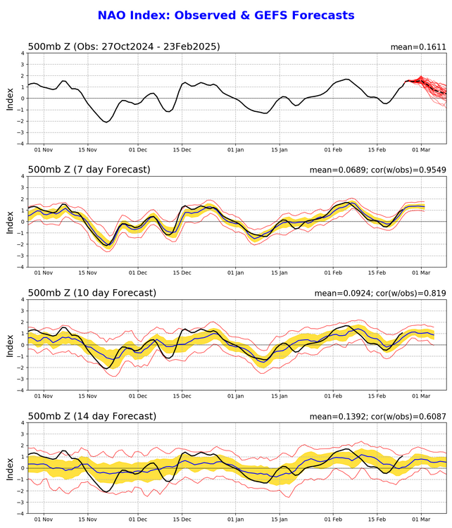
At least for the near future, I am thinking that a mid-March convective potential are in the works for portions of the Southeast. Just looking at it from a synoptic point of view, it does look like a good chance, however, there are some pitfalls that I am seeing with this system that could make mid-March a complete bust also (sorry, this is me being a realist). For starters, the NAO is forecasted to be in a positive phase as we head into spring (March 1st) and looks like it will take some time before shifting into the negative phase. Will it shift into a negative phase before the mid-March time frame, that remains to be seen. Personally, I prefer a negative phased NAO as it allows for troughs to dig deeper in which turns gives a better chances for chasing opportunities. While I also know this not always guarantee, it is something I look for and keep in mind when doing these sub-seasonal forecast. The second issue I see with this setup is another chance of a blast of cold air to hit the Southeast. As I stated awhile back, any more cold arctic airmass at this stage of the game could offset/delay the start of spring chase season. Looking towards the end of this month into the start of March, long and extended range model guidance shows yet another shot of cold air to impact the Southeast. While this next cold shot of air does not appear to be as strong or will push as far south, it could still impact how quickly the atmosphere recovers in time for the severe weather potential. So with all the bad that was mentioned, what are some positives going into mid-March? The start off, the long and extended range models do show a quick warm up heading towards the middle of March. The quicker the atmosphere recovers, the better the chances we have at the first chase of the year. Secondly, the 500 mb flow of the CFS and the GFS are very similar and favorable for a classic Southeast event going into the middle of the month. Now take this with a grain of salt. A lot can change between now and then but it is important to know that there are some signals showing up in the model guidance already, not just in the CFS. Thirdly, the MJO is forecasted to be in the Indian Ocean phase around this time as well. Lastly, the NAO phase. While there is not a lot going for the NAO phase at the moment, model guidance does show the shift in the NAO phase from a positive to a negative phase going forward. The timing of this shift will be key since the MJO phase is expected to be in a favorable phase by mid-March. If all these things can line up just right going into mid-March, would not be surprising to see or even expect a decent chase opportunity around mid-March to kick-off the 2025 chase season.
-
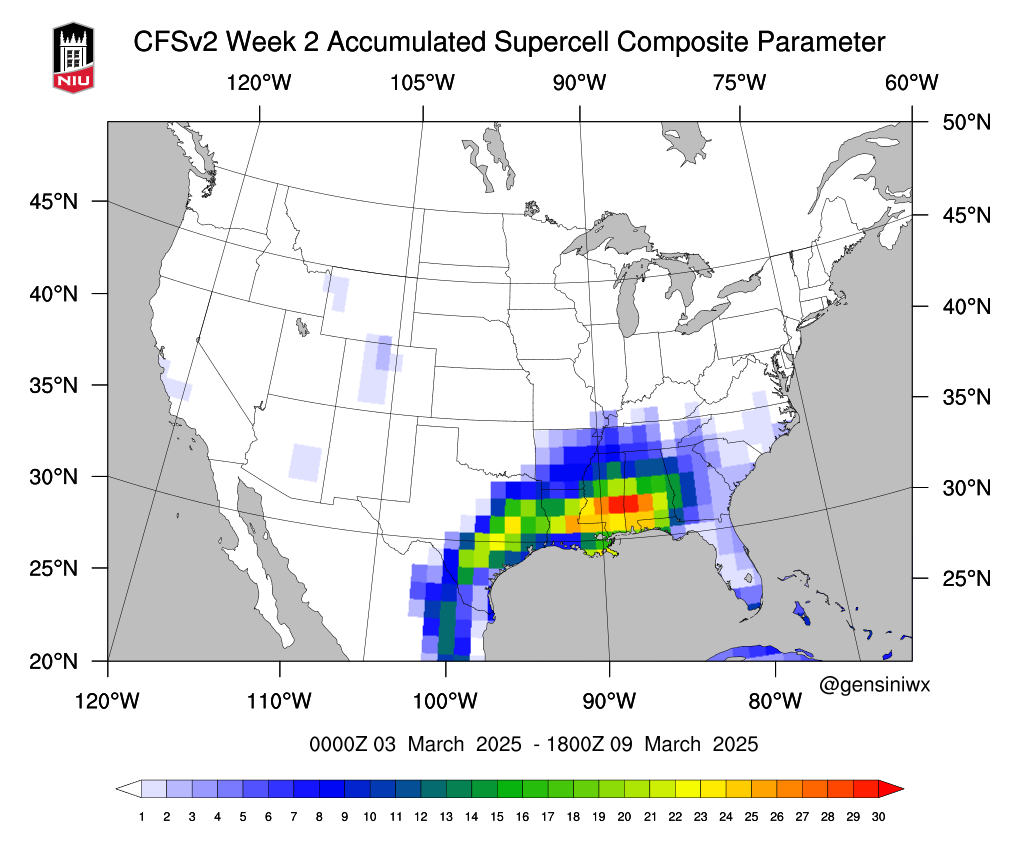
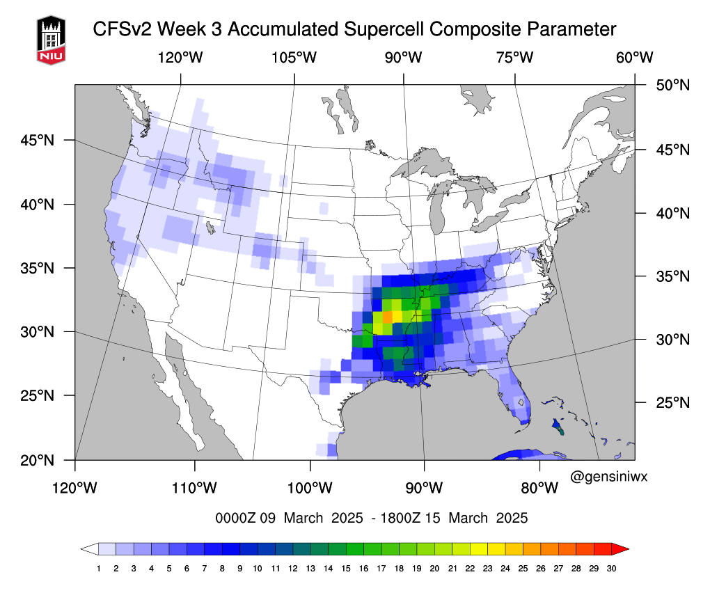
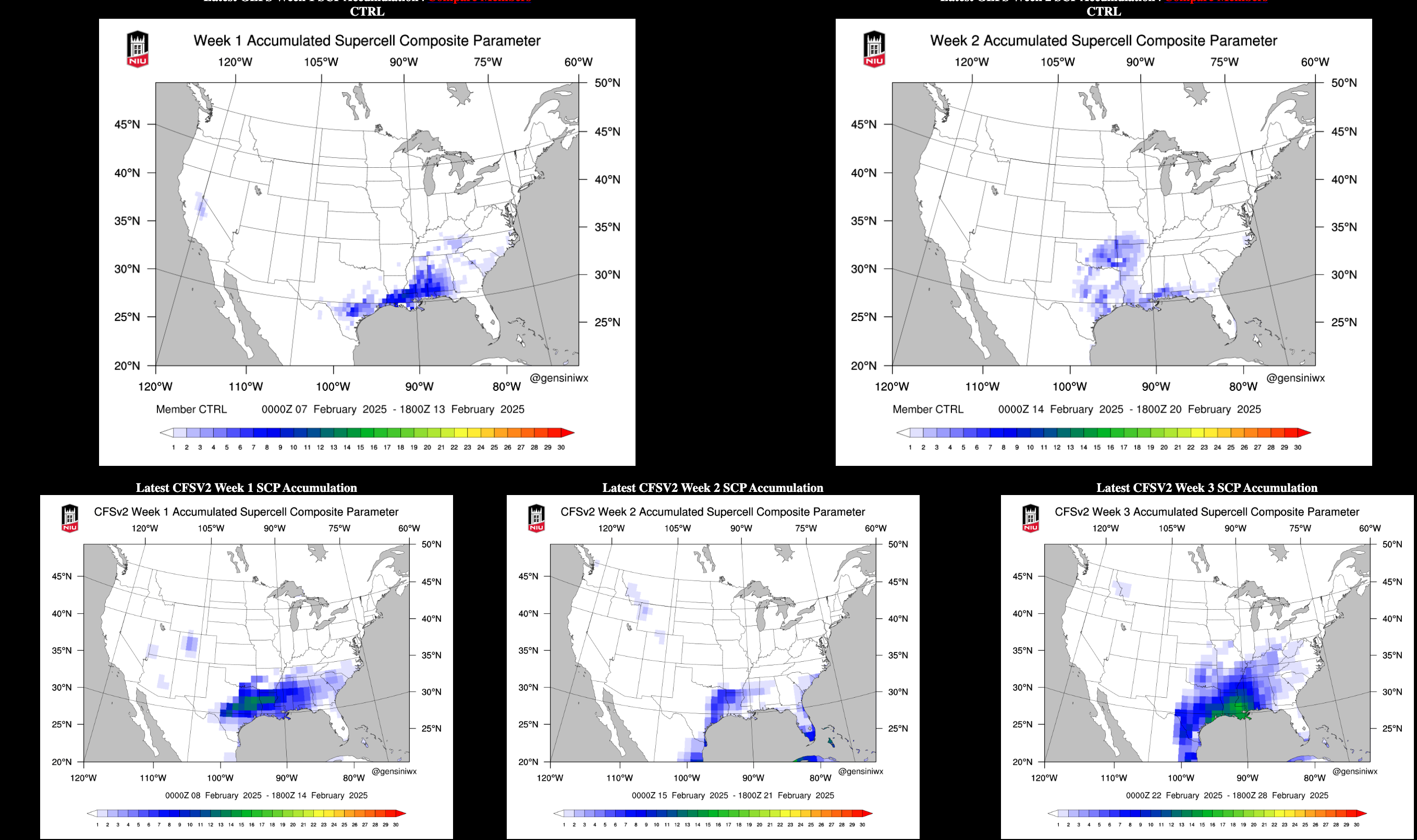
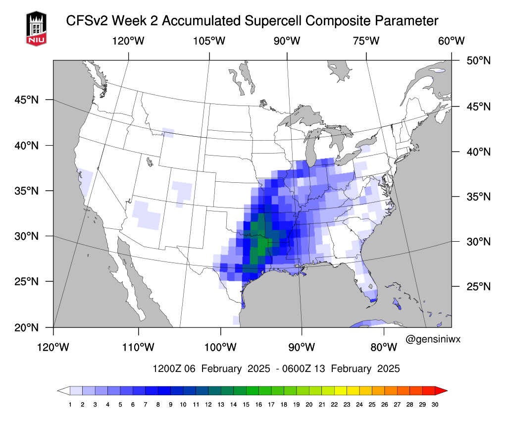
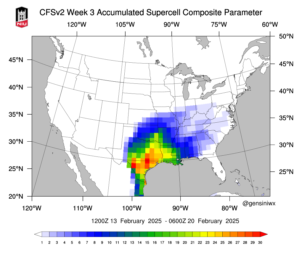
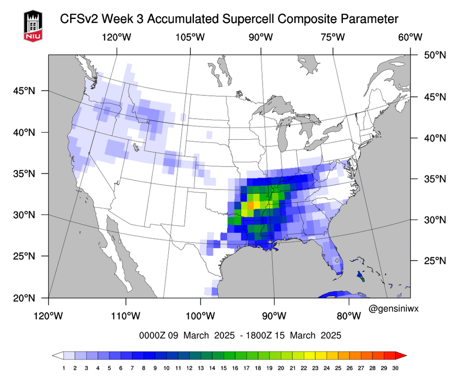
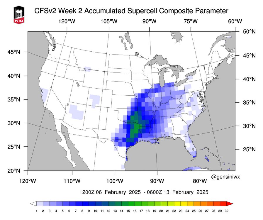
Haven’t looked in full detail but the CFS Supercell Composite is signaling something around late February into mid March with the chances being a lot better in the March timeframe which is when the MJO is expected to be in the IO from what I have seen. My patience maybe paying off.
-
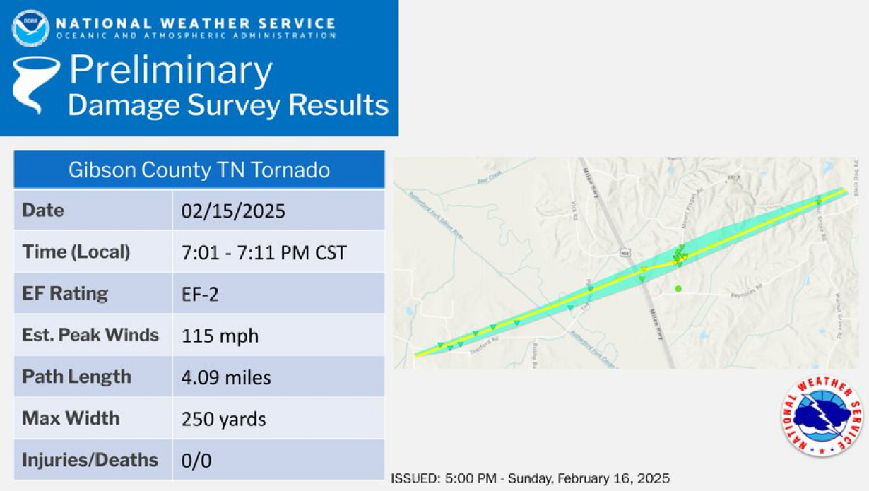
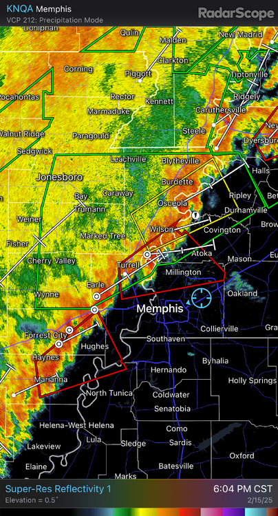
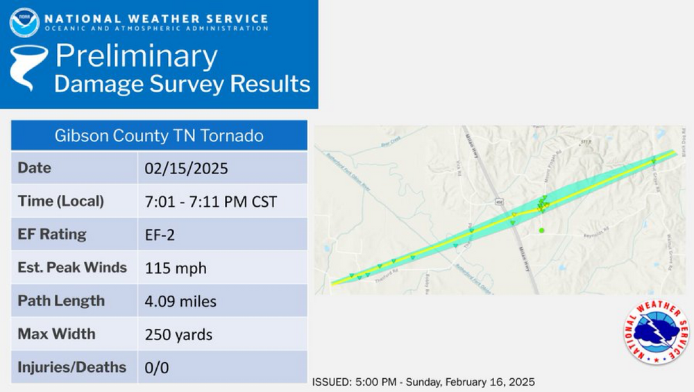
At least 1 confirmed tornado has been confirmed in NW TN and it was EF-2. More info can be found in the graphic.
-
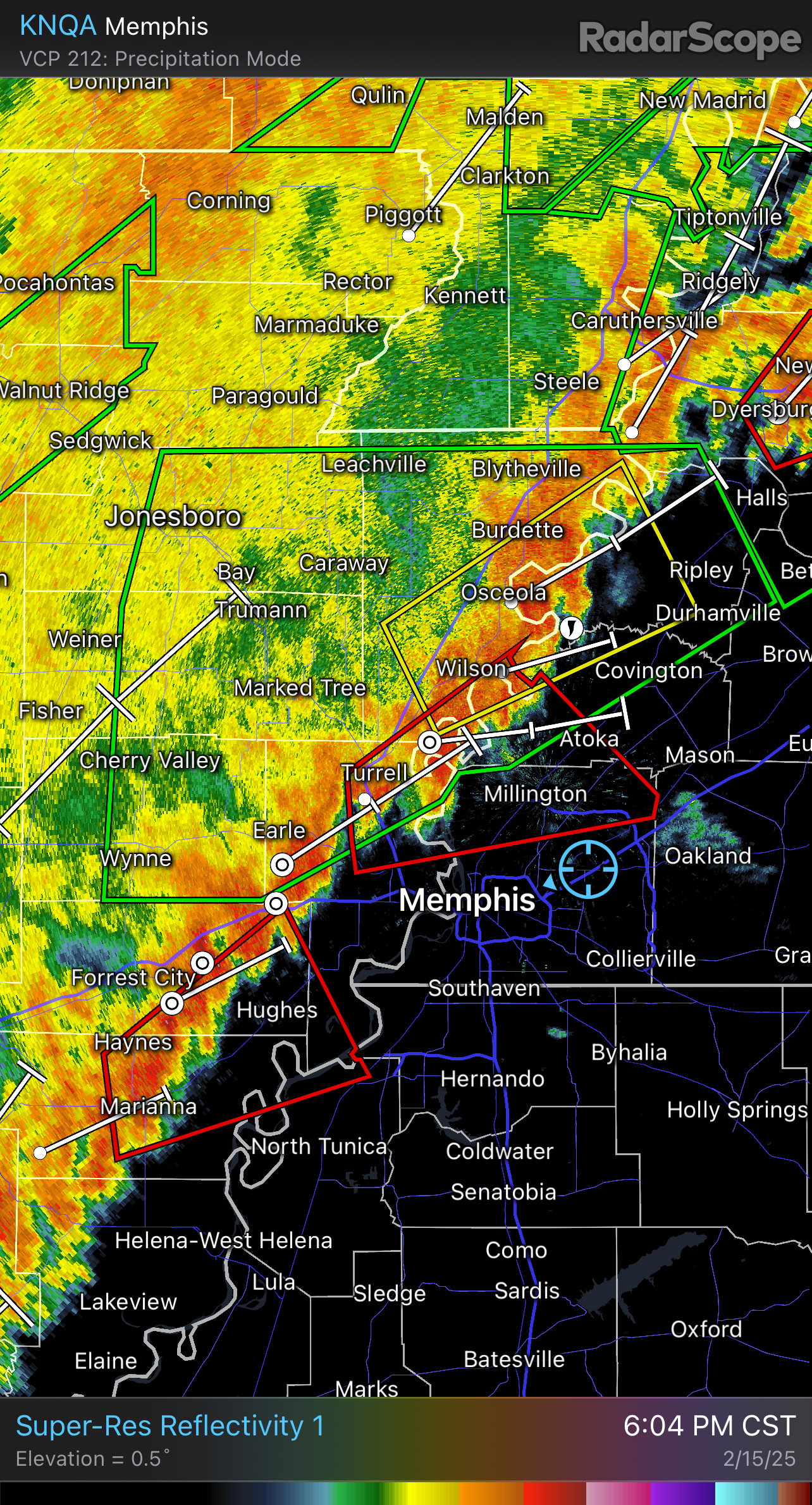
No tornadoes that I have seen or know of. The tornado warning ended up being dropped no long after I grabbed the screenshot of the image I have posted. I did not chase, I was just waiting for it come to me while at home. Northwest TN got hit hard with damage and from what i understand now a dam failure.
-
Unfortunately where those discrete cells develop at is in bad chasing terrain (ie hills, trees,and etc) plus near night time spells no go for me.
-
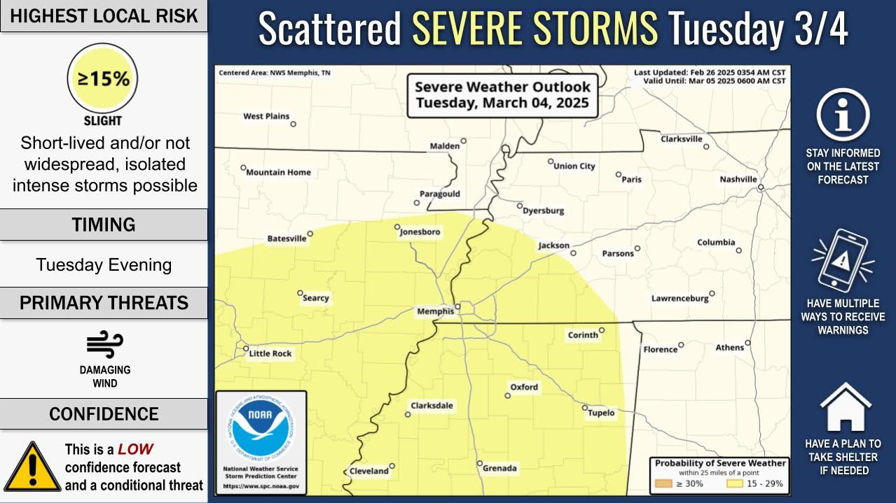
Nothing like good ole' Dixie being Dixie with a QLCS event occurring near night time. If model data continues to show QLCS, which I suspect it will be, will likely not be chasing tomorrow. While temps and dew points will be more than sufficient, timing and storm mode does not appear to favorable at this time. Will continue to watch and monitor situation for the next several hours.

-
What makes you think that with the MJO?
-
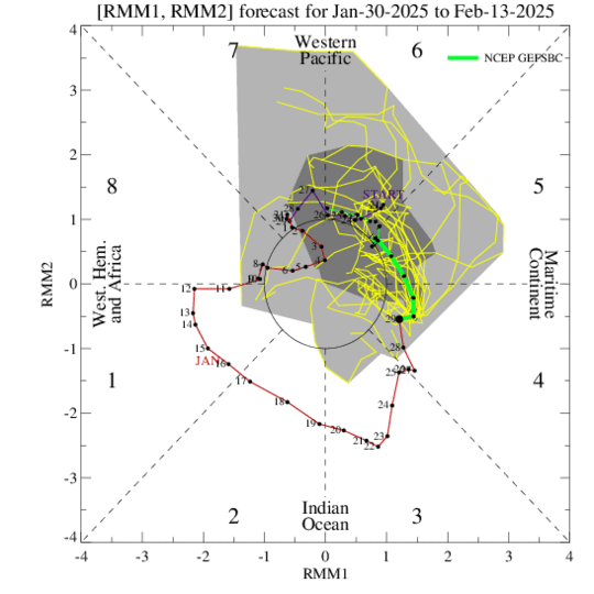
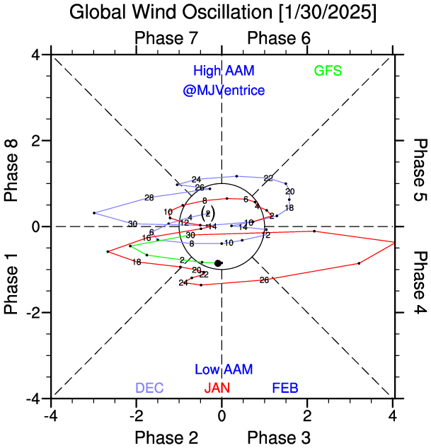
Quite possibly, but the AO is expected to be negative as well in this time frame and us being in Feb into early March has me concern that the cold arctic airmass could contaminate some of the other teleconnections and mess up the pattern. I’m not saying it will or will not, I am just saying it is something to watch for going into March. I do like the MJO and ENSO phase we are in or trending towards. Maybe a strong enough MJO in the right phase could off set the AO but time will tell. Also have to see the NAO and PNA as both weren’t in good phases either but it only takes one to make or break a forecast. For now, have my eyes set for Saturday and will get back to the MAM after this week.
-
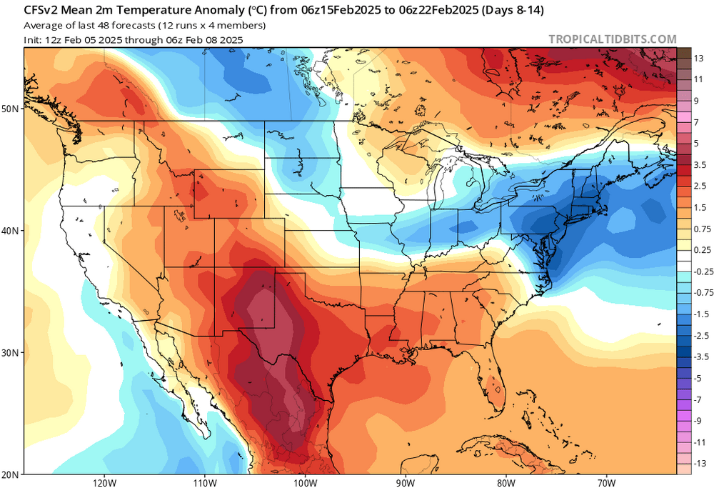
Continuing to watch for a potential chase day towards the mid to late Feb. As of right now, the CFS is continuing to show the potential for convective storms towards the middle of the month, potentially towards the end of the month. For temps, long range models are continuing to show above avg temps between Day 8 to Day 14. Anything after Day 15 temps begin to return to normal before another shot of cold arctic airmass returns to the region by the start of March. If this is true, the cold arctic airmass could delay the start to the spring season for portions of the country. While this is not set in stone, it is something to consider going forward and picking out potential chase days and/or weeks going into March (will be another discussion for another day). The real question of the next couple of weeks will the teleconnections be aligned to help better the chances? At this moment, it is hard to say as several of the teleconnections will be out of the phase to help support or even enhance the chances of a favorable storm track. Will have to continue to watch and monitor the models over the next several days and see how things play out. If Feb. decides to be bust this year, I will begin to focus on the MAM to AMJ timeframe. There is nothing guarantee of course, this is me just looking forward to the 2025 Spring Season and hoping to get a little tease before peak season gets here.


-
It seems like it could be one of those mini supercell days from the wording and the low CAPE environment.
-
Will keep this short, want to save the good stuff for MAM or try to at least. The CFS is continuing to show potential for a mid to even late Feb severe weather potential. Some of the things I do like is the ridge off of the Appalachian Mountains seems to be weakening, this is based on both the CFS and the recent EURO weeklies (not shown here) However, the NAO does remain positive well into this same time frame. Can the AAM get into a favorable phase as well, it is possible, but will it stay there is another question. At least for now, it is something to watch for still going into the month of Feb. I am liking what I am seeing with above abv temps in the long range along with some troughness out of both the CFS and the EURO weeklies towards the Rockies and Central Plains. Will like the NAO to be negative, as it gives a better opportunity for troughs to dig a little deeper south but one can only hope at this stage. It is a very much see and wait type situation at the moment. But seeing the model guidance trends, mid to late Feb could provide a teaser into what MAM could have in store for us.

-
Well, if this comes to fruition, my forecast would bust oh well.
-
To be fair with last year’s ENSO, we were in an El Niño going into a La Niña. Historically, El Niños tend to have less active tornado season across the Southeast as a whole. When we made the switch to La Niña, it was a little late for the Southeast if I do recall correctly. That’s why I am a little excited about this season since we are in a La Niña maybe it will give more opportunities to chase. Now this will be dependent on the other teleconnections including the AO, MJO, PNA and the NAO.
.thumb.jpg.049f4a7f726ada07e8cd30bd17e713cb.jpg)