.jpg.60032c348ffbfe96450212c98c077602.jpg)
vortexse93
-
Posts
93 -
Joined
-
Last visited
Content Type
Profiles
Blogs
Forums
American Weather
Media Demo
Store
Gallery
Everything posted by vortexse93
-
I have other obligations and plus the model guidance showing a linear model for much of the day. In also decided that Saturday will likely be my next best day to chase since I will be available for much of the day to chase and it will be closer to me so a win win for Saturday.
-
I will not be chasing tomorrow unless something just happens to develop really close to me. I will be saving my energy for Saturday potentially as I will be free all day to chase. Virtual Chase Target: My chase target will initially be focused on the isolated storm cell that the HRRR has developing all by itself in an very favorable environment which makes my key player as of now. My secondary target will be tail end of storms in southeastern AR in the event the lone cell fails to develop in MS. The spacing between the first line and the secondary line in South-Central Arkansas should be sufficient for storms to take advantage of the environment. If I wanted to be more aggressive, I would target the secondary line, but that is near some unfavorable terrain, but could still worth attempting as it approaches the MS RVR.
-
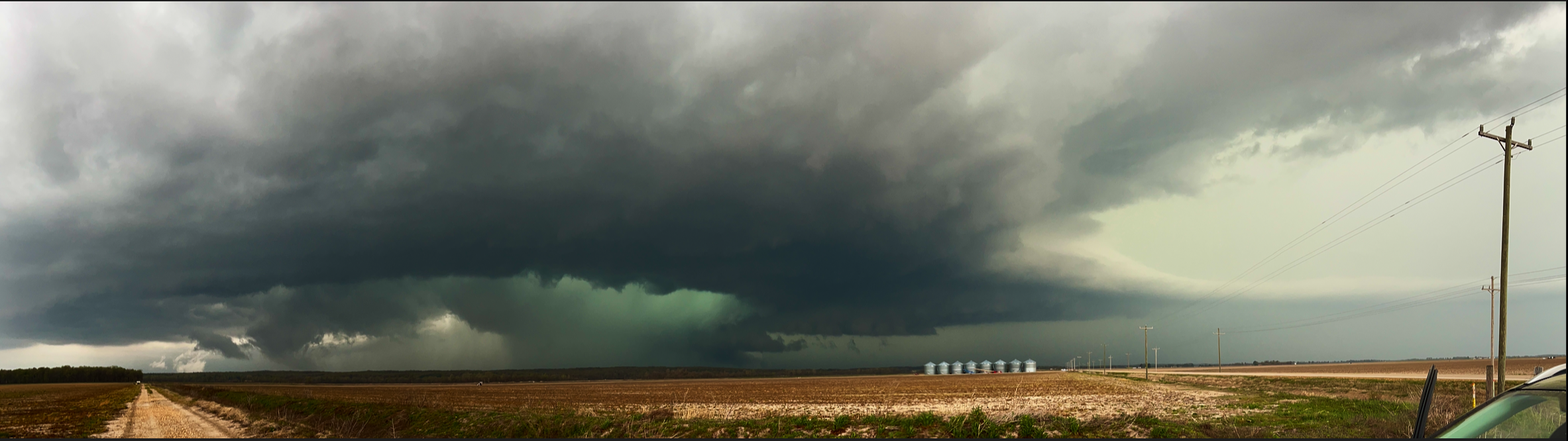
I do not share photos on here often but this was a beauty in NE AR and MO Bootheel region. While I did some minor edits on this picture, the sky was so green it is impossible to describe. Also, one of the only times that I have ever seen the inflow band so clear out in this area also. In all, a successful chase. Warning!!!! If you want to share the photo on other social media platforms or websites, come to me first before sharing! This is a teaser of what I have on camera but wanted to share with the group on here at least since I have been busy the last few days.

-
HRRR decided it will not give me sups to chase this evening. Will make an attempt to gather lightning photos and go from there. Will see how model data changes throughout the day, but if trends in the model data continues then any hopes of chasing will be doubtful.
-
Model guidance suggest that storm development will be close to sunset. Will stay within the JAN area in hopes of getting some lightning or storm photography. Discrete cells look to remain few and far between out ahead of the line, this cloud be a result of some sort of boundary that the models are indicating for these discrete storms to develop off of. Other than that, majority of the storms will be associated with the cold front. Any discrete storms that do develop, will either merge within or into some sort of linear system as cold front front begins drifting southward during the late evening into the over night hours. Synoptic forcing will be weak, but there will be enough directional shear present from the sfc to the mid-levels to support tornadic cells. Given the weak synoptic forcing, the tornado threat should be low for the most part.
-
Adding to what @nrgjeff had posted, while it is way to early to determine exact details for Sunday, the 18z GFS and NAM forecast soundings do show some glimmer of hope for a potential chase in the MS Delta into North AL. One concern that stands out to me is the mid-level capping inversion that is very apparent in the NAM sounding, not so much on the GFS sounding. If that cap does not erode, then it could be cause for concern for storm development during the afternoon/evening hours. Outside of that one issue, veering wind profile, with about 700 J/kg to 1,000 J/kg of CAPE, SRH values well into the triple digits, looping hodographs and even steep lapse rates present within the atmosphere is a good sign. All that needs to be watched are boundaries, as mentioned before, and for myself at least storm mode.

-
Wednesday, had little hope for anyways, if things do get interesting, I have to Res in Jackson, MS that can hopefully be of some use in the attempt to get structure at the bare min if not lightning photos. Sunday might be one of those if you are close take the gamble anyways pending storm mode, which is what I might end up doing. If I do go out, then it will but for the sole purpose of getting structure and landscape photography nothing more across the Delta.
-
I have done some analysis for AMJ and I think April will continue to be active. As for May and June, it looks bleak will save that discussion for another time.
-
I have sups
-
Looking at the model guidance and seeing the 12z HRRR, will stay local and if something comes my way I will attempt to chase it then. I would think about heading east this morning, but will have to fight the QLCS on my way back and not worth the risk, especially on a day like today where storms will spins.

-
I would not dare chase south of I-20 towards that direction on a slight risk or enhanced risk day. You think I am going to chase on a moderate or high risk day, that is crazy lol
-
It might be a road of this
-
00z HRRR is really concerning me. I haven't see the HRRR this consistent. Usually there is some difference or some sort of back and forth. Really concerning and FV3 is not showing much difference.
-
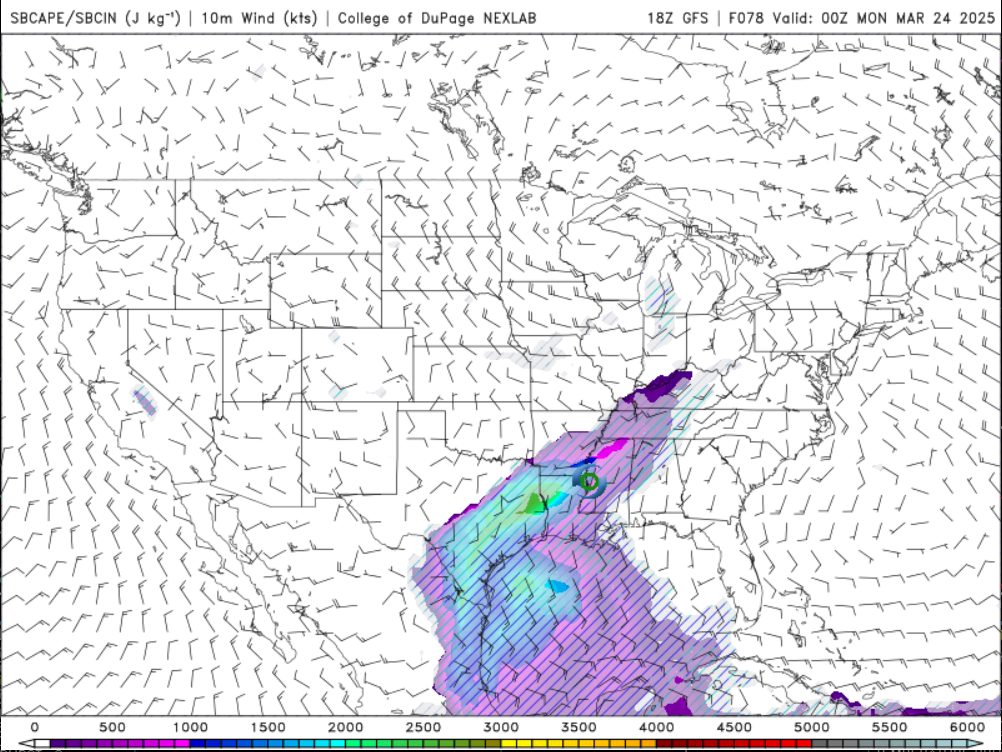
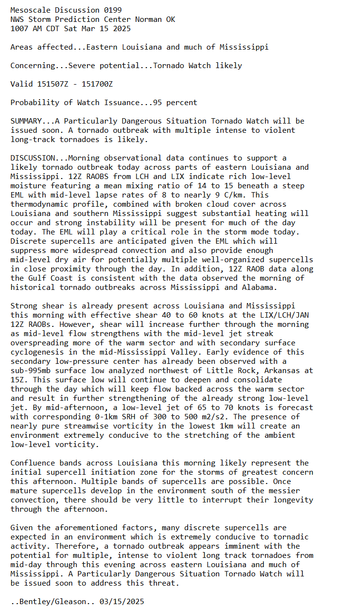
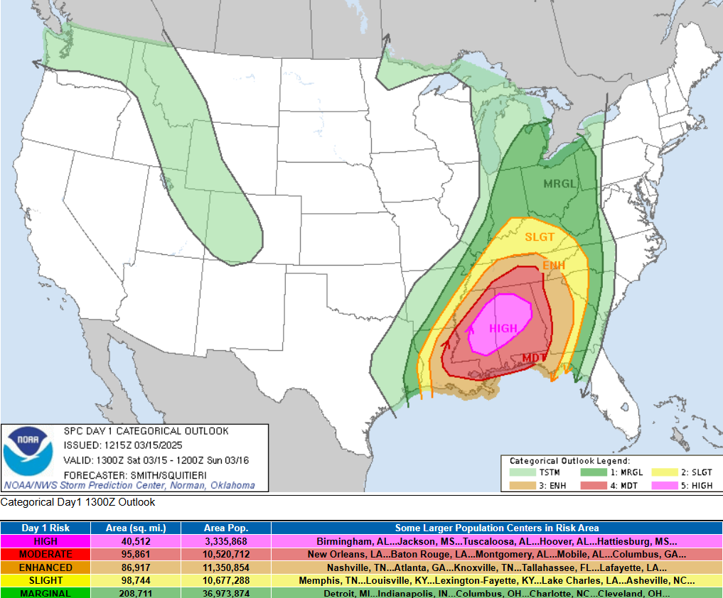
No chase for me tonight as storm development will after sunset. This will likely be my last full breakdown discussions before tomorrow, any updates from will likely be brief or will be quoting SPC MDs for much of the day. Tomorrow has me very concern for long-track and violent tornadoes across much of Central MS as model guidance has severely backed off on any morning time convection for the region. My second concern is the possible eastward progression of a dryline ahead of the cold front. Dry lines are not common for this region and could be the reason why models have supercell heavy the over the last couple of days. Drylines are excellent lifting sources for storm development and are more common out in Tornado Alley. Timing of these storms can be as early as mid-day tomorrow and will most likely remain discrete and supercell storms. These discrete storms will not have the biggest tornado threat associated with them, but will also have the potential to produce long track and violent tornadoes tomorrow. Since I am new to this forum, I do not use that language very lightly or very often. Tomorrow has the day to be a very eventful day. For chasing, had thoughts to chase, however, having to fight any potential supercells on the way back or QLCS storms in this type of environment is not warrant for me. However, as @jaxjagmanmentioned, if things line up properly, the storms will come to me. For this reason, I will remain local for tomorrow's severe weather threat. I have some local spots that will be great for viewing if the opportunity presents itself. Tomorrow is not a day for inexperience chasers to be chasing in Dixie Alley. The setup were more into the Delta, I would most be considering a chase, but that is not the case. For those that go chasing, be extremely careful and mindful of the weather conditions and the road networks around MS/AL.
-
18Z HRRR is trying to sign my death certificate
-
For me personally, will need to see how Friday plays out before making any decision. While I would typically have something a little more concrete, I do not this time around as CAMs are struggling one way or another. Also, Friday night into Saturday morning will dictate what will transpire across MS and AL as whole. As it stands right now, will prep as if I were to chase with the the understanding that it will most likely be a no go for me at this time. The last thing I wan to do is force myself to chase something that the risk is not worth the reward and put myself in unnecessary harm. Will continue to monitor model guidance and trends at this time before making a final decision.
-
I am currently keeping my eyes out for Friday into Saturday. By glancing at the models over the last few days, I am personally not liking the timing nor the placement of this setup. This round I may end up sitting this one out. For me personally, it will be a stretch to make near Northeast AR/MO on Friday. For Saturday, the threat will be to my east and chasing east of I-55 is nearly impossible. While there are some spots that are decent to chase in, I am not much on fighting trees and hills. Plus, have some concerns in how Saturday morning may play out with the morning storms ahead of the main show. Have seen time after time when morning storms tend to ruin events. Not saying that will happen, it is something to keep in the back of the mind when making these decisions. Will continue to watch and see what the higher res models are showing by this time tomorrow.
-
I noticed a lot of chasers being super aggressive with their forecast and always hyping things up which is why I don’t listen to a lot of it. Just because there is severe weather potential does mean it equals emergency tornado outbreak.
-
I totally agree with this 100%. This also why I tend to be down to earth and not get so into hype and excitement.
-
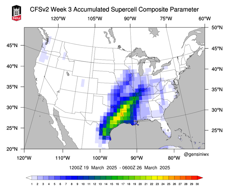
March 14th to March 15th has everyone on stand by and rightfully so. While there is good model agreement at this time, there are some slight differences between them. Personally, I am liking the track and speed at which the EURO model has for this system. With a -NAO, troughs should be digging a little further south and should have be moving a little slower, which the EURO does show. The NAO is forecasted to remain negative well past the 15th of March, so the faster moving solution the GFS is showing, I am less confident in at this time. With such a big warm sector forecasted for the 14th-15th, this reminds of a similar setup back on March 31st, 2023 where there were two distinct areas for severe weather, one in AR/TN/MS and the other in the Midwest that was associated with the main sfc Low if I do recall correctly. In NO WAY, I am saying this will be a repeat of that event. I can not stress that enough! What I am saying that the pattern is there to see two different areas being the gun for severe weather. However those details can not be fine tune at this time and the size of the warm sector and the SPC Day 6 Outlook reflects that as well. The finer details for March 14th to March 15th will determine my storm chase decision but for now it is on my radar for the time being.
-
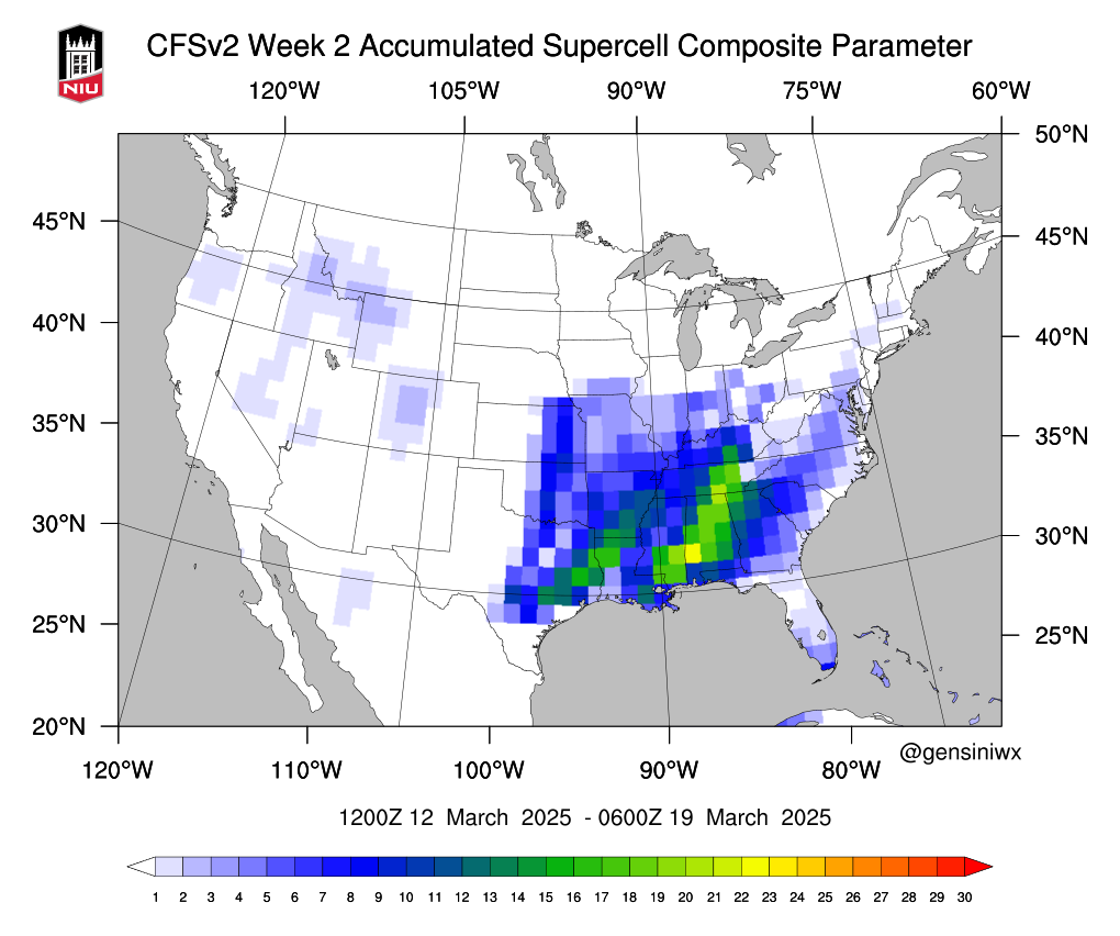
I have not looked into the details of the overall weather pattern going into the second half of March, but the current CFS does have my hopes up at the moment for a potential chase. Will have a more detail discussion/breakdown later on this weekend for this time frame. For now, will continue to watch model guidance and trends rest of this week. Until then, y'all have a good rest of the week!

-
Last time I looked, the wind gust in Jackson MS was 44 mph at one time and that was before the arrival of the line around noon today.
-
As a storm chaser, this is a no go situation for me down here in Jackson. Model guidance has continued to show instability struggling to advect north of I-20. Model guidance showing southwestern MS into southern Louisiana as the best environment for tornadic storms given that synoptic forcing and favorable directional shear will be in place (this includes the best potential for supercell). In Southwest MS, it is heavily forested so chasing down that way is nearly impossible and very challenging also. If the setup was for the Delta, would make a more of an attempt, but that is not the case today. The question of the day is: Will storms out run the environment? With the strong low level jet forecasted to be 70 to 80 kts and bulk shear values around 60 to 80 kts, this could very well be in the cards. With this being a possibility, it’s not worth chasing either. For me, pending timing and where the breaks in the line ends up occurring, may head out to the Reservoir to get some pictures and lightning photography. The southern part of the Reservoir will give me the most open view towards the north looking over the water. While I don’t think the greatest tornado threat will be to my north (reasons stated above) I think it will be a good opportunity to at least test my equipment for the season at the very least.
-
This is some good news for me at least. Tuesday is still looking like a poor chase day for me and will look ahead once Tuesday is over with.
.thumb.jpg.049f4a7f726ada07e8cd30bd17e713cb.jpg)