
mnchaserguy
-
Posts
145 -
Joined
-
Last visited
Content Type
Profiles
Blogs
Forums
American Weather
Media Demo
Store
Gallery
Posts posted by mnchaserguy
-
-
Sun is out and I see blue sky here in the north metro lol
. -
Sadly this has been the trend with the models (I.e. show historic storms then go down to reality). Your getting an awesome storm but the historic model runs make you feel robbed.
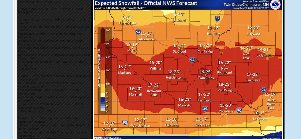
Exactly. It’s still a big storm but a bit of a letdown after there was so much consistency for so long with the high end totals. I should still end up with 15-17” by the end of it.
. -
4.1” at the airport as of 6am. Definitely the lower side of guidance but they were calling for 4-8” in this first wave, so not a bust. Really strong banding overnight in the south metro. Shame models are showing a substantial drying trend but we should have know those crazy totals from a couple days ago were unrealistic. I believe the record February snowfall at MSP is only in the 13-14” range so the monthly record is still very much in play.
Yep. Top 5 snowstorm is still possible. Top 10 should be a given.
. -
3.5-4” here so far. Definitely low compared to the 6-8” forecast by MPX. Looks like a foot tonight into tomorrow is a solid better. Probably unlikely we hit 18” at this point. Big storm but significantly lower than what was shown by the models for several days.
. -
Sucks when they trim the floor down to a total that still exceeds most of our season totals...
It’s a bit of a let down when we go from being close to breaking an all time record to this. Still a big storm but not as impressive as it looked the last several days.
.-
 4
4
-
-
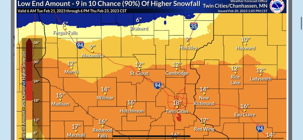
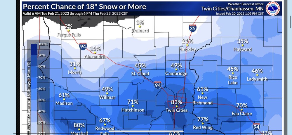
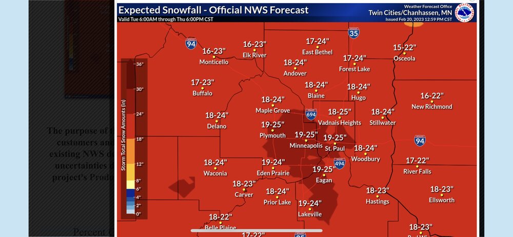
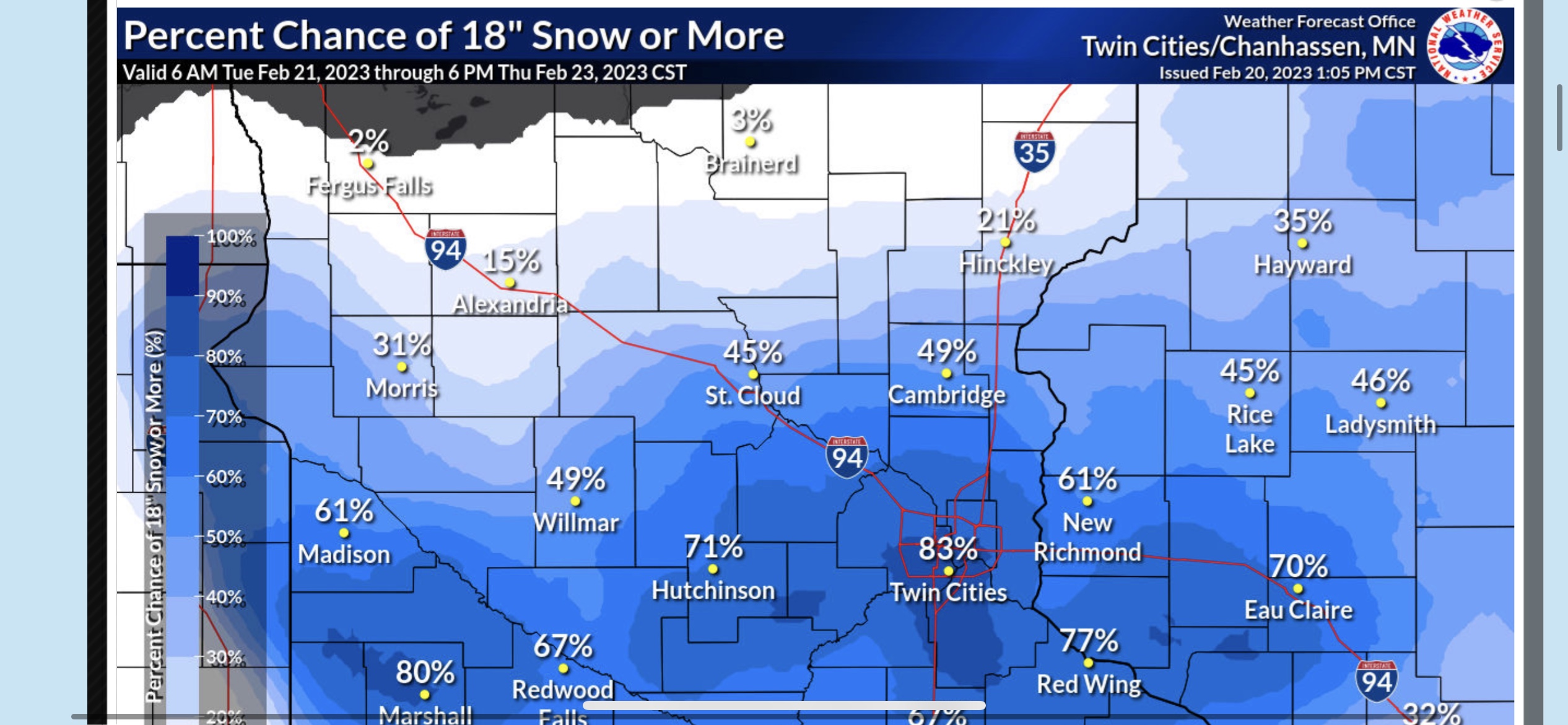
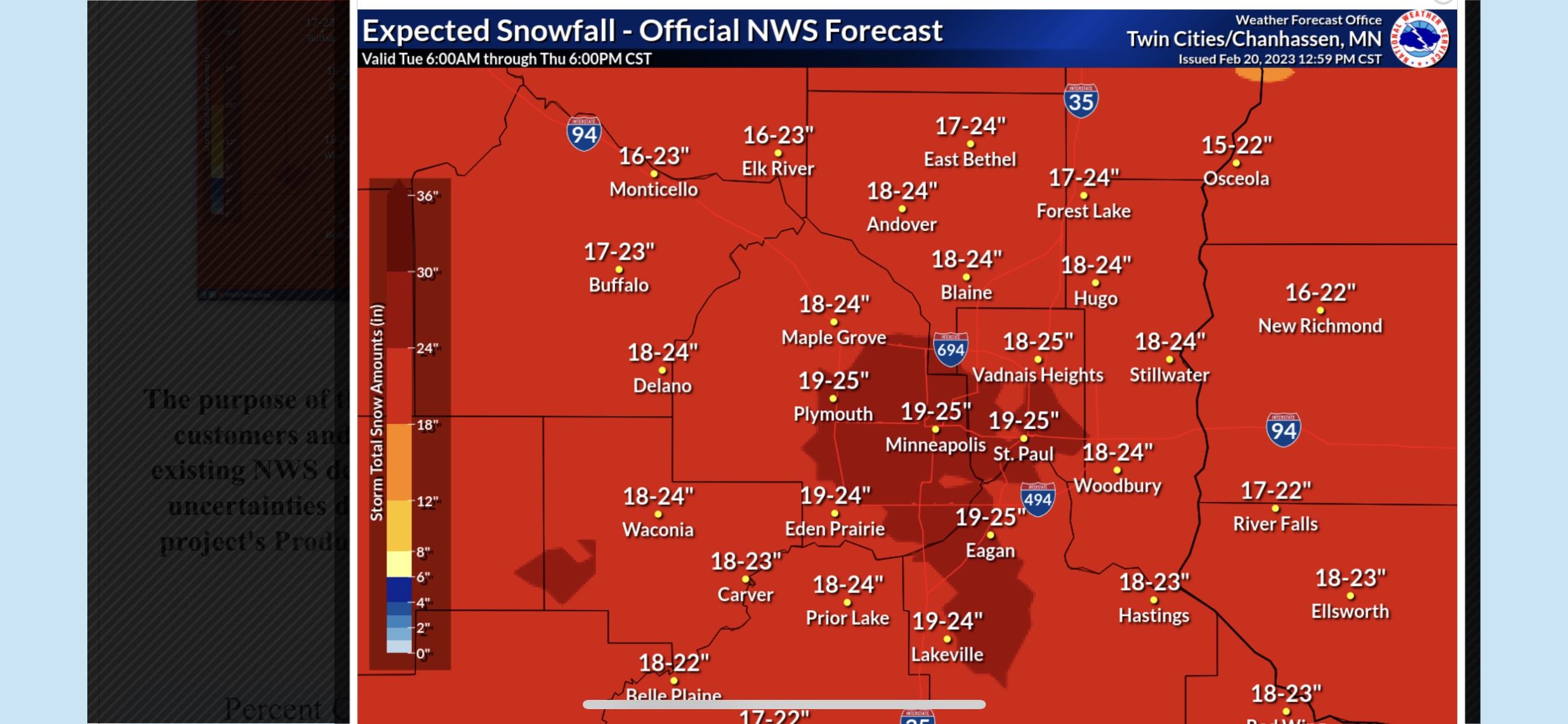
Trending in the wrong direction for Minneapolis. Mpx trimmed the floor from 18” to 12” and the probability of 18” has gone from 80% to 30%.
.-
 1
1
-
-
Most CAMs are really honing in on south central and southeast MN getting the 24”+ totals. I’m guessing 18” is a lock for me with some potential of 20-22”.
. -
Since when did this board start bowing down to the short range models beyond 36 hours?

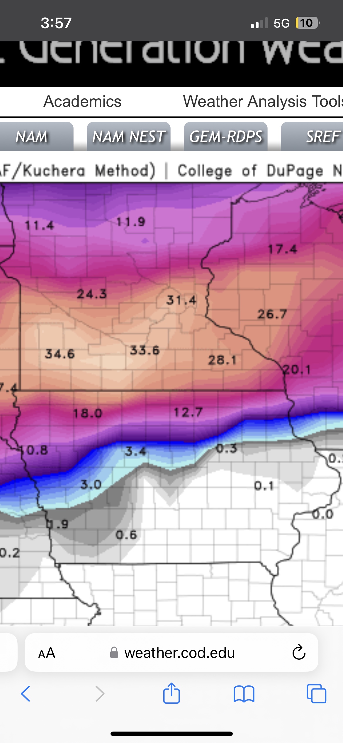
Short and medium range models are showing the same thing the long range have been showing for a week. Not sure what the problem is here.
.-
 1
1
-
-
My P&C has been upped to 24.1”
No words
My point and click on the NWS website is 18-31”. Never thought I would see the day.
. -
18z GFS is farther south with the initial band but still managed to bump up our totals for the rest of the storm. I don’t even know how to comprehend this.
.
-
1
-
-
It’s just unbelievable what the models keep spitting out, and with a metro bullseye to boot. Todays teaser clipper dropped more then expected too. Still trying to temper my expectations but it’s tough with such consistency
Me too. I’m still waiting for the bottom to drop out somehow but it doesn’t seem like it’s going to. Maybe we’ll have a legit shot to break the Halloween Blizzard record.
. -
Our floor is 18”. My god. If this verifies it’ll be the biggest snowstorm I remember seeing first hand. And I’ve seen some big ones around here.
.
-
2
-
2
-
-
I may never see a forecast like this around here again.
.
-
5
-
2
-
-
Measured 2" in the driveway at about 7:30 this morning. Maybe another inch or two today.
-
11 minutes ago, OrdIowPitMsp said:
Probably the 18z NAM

Yeah but the Nest seems an odd one to pick to make an official forecast from, especially when none of the other models (CAMs or otherwise) support WSW criteria snow for most of the metro. Idk maybe I'm missing something but I've been following weather for a long time and I don't see what they see in the models. 4-5" looks like a pretty solid bet.
-
New zone area forecast for me has upped my total to 4-6" for this storm. Probably not quite enough for a WSW but on the upper end of a WWA. I'm a bit surprised to see that total get bumped up. Not sure what MPX is seeing in their models but from everything I've seen I look to be pretty solidly in the 3-4" range. If these updated totals are accurate then we should see another row or two of counties on the north side get added to the WWA and a row of counties get converted to a WSW on the south side of the Twin Cities.
-
30 minutes ago, OrdIowPitMsp said:
0.7” of snow yesterday. It’s been a very wet January and winter as a whole.
And most of that water has nowhere to go since the catch basins in the streets are buried under mountains of snow from the plows. Gonna be real interesting if things freeze up quick the next couple of days.
-
We're too busy watching our thicc snowpack get ruined by a mid-January rain storm here in Minnesota. Not often we have p-type issues around here this time of year...
-
1
-
-
It's almost not even worth mentioning right now since we're a week out but I find it really interesting that the GEFS already has MSP at 6" for the mean snowfall for next week's storm. That's some pretty good agreement for being so far out still. Wonder if the Euro will follow the GFS or if the GFS will follow the Euro.


February 21-23 Major Winter Storm
in Lakes/Ohio Valley
Posted
I wouldn’t be surprised if we don’t hit double digit totals for the entire storm. Snow having a really hard time getting going on the north side.
.