
mnchaserguy
-
Posts
145 -
Joined
-
Last visited
Content Type
Profiles
Blogs
Forums
American Weather
Media Demo
Store
Gallery
Posts posted by mnchaserguy
-
-
Weenie post of the day courtesy of the Canadian
.
-
 3
3
-
 2
2
-
-
Looking more and more likely that our snow season gets in MSP is far from over. Guess we’ll just have to be happy to get precip in whatever form we get it.
. -
At this point my biggest concern is the complete lack of snow across most of central Canada. If things don’t change (and I don’t think they will) I bet the jet stream will shoot up well into Canada by the beginning of summer.
.-
 1
1
-
-
Watching our radar tonight has been fun. Lots of banding and random forcing going on. One final big band developing right over the heart of the metro.
.-
 2
2
-
-
One of the more unique WWA and WSW combinations I’ve ever seen. Glad I finally got under the over performing band for a change.
.
-
3
-
-
60 degrees in Minnesota at the beginning of February on the GFS is not something I want to see.
.-
1
-
-
Going to the Wild game tonight. Snow is actually coming down pretty good in St Paul right now.
.-
2
-
-
Snow band seems to have hit a wall. Can’t make this crap up. I may end up with nothing.
.
-
1
-
-
The low moving 50-100 miles farther east than the models showed yesterday is reallf screwing us too. Instead of moving north towards the northwest part of lower Michigan it’s now forecast to move northeast towards the northeast LP. Instead of getting light snow all day tomorrow we will be lucky to get a couple of hours.
.
I should also add the models are showing a weaker low. Instead of bottoming out at 968-970 mb it’s bottoming out at 980-982 mb.
.-
1
-
-
Of course the one time the CAA is ahead of schedule it wipes out our snow chances.
The low moving 50-100 miles farther east than the models showed yesterday is reallf screwing us too. Instead of moving north towards the northwest part of lower Michigan it’s now forecast to move northeast towards the northeast LP. Instead of getting light snow all day tomorrow we will be lucky to get a couple of hours.
. -
Not sure if it’s a lack of forcing, dry air from the north, a combination, or something else, but the snow band has pretty much stopped advancing towards me. It also looks like it’s falling apart. I’d say 1-2” is a total bust for MSP after what almost all of the cams showed yesterday. I may get lucky with a couple inches on the backside but just to my northwest will probably end up with nothing after models showed upwards of 3-6” all the way into central MN. MPX mentioned in their AFD that the initial wave developed way further south than forecast which meant we didn’t get any WAA snow out of this. Our only hope is some consolation snow on the backside tonight and tomorrow.
. -
This is gonna be a pretty epic bust here in Minneapolis.
. -
MPX went with a WWA for me instead of a warning. Could still end up with well over 6” of snow but it’s going to be thanks to the long duration, not high rates. Looks like we will top out at about 0.5” per hour around here. Good luck to those in the heavier bands. Looks like there should be some persistent 1-2”/hour bands closer to the low.
. -
I'll take the hires Nam. If only the weather was easy aa picking your favorite model run lol.
There have definitely been better runs for Minneapolis but I think the 18z hrrr shares the wealth the most from what I’ve seen. I’m happy to see Chicago get their blizzard as long as it doesn’t mean we get completely missed like last week lol
. -
Not really. Lol. Screws the parts of IL that also missed out on last storm. And Ohio Valley really getting the shaft.
Unfortunately this storm isn’t going to dump snow on everybody. That’s just the reality. The 18z hrrr would give the majority of the sub a nice storm.
.-
1
-
-
I wish we could just agree to take what the hrrr shows right now. Chicago gets its storm, Minneapolis gets a nice dumping, Michigan gets a nice storm, and a lot of snow in between. This is about a best case scenario run for this sub.
.-
1
-
-
18z hrrr coming in south from the 12z run, which was already on a southward trend. Maybe the GFS and Euro were right again all along. If that’s the case, why are the short and medium range models so bad? Almost useless.
.-
1
-
-
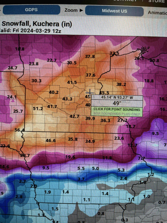
MPX bumped up their snow totals to 4-6” through tomorrow night for the winter storm watch for the Twin Cities. Doesn’t seem like they’re buying into the additional snow on Saturday yet.
. -
Gfs stays south on the 12z. Still gives Minneapolis some snow on Saturday. No matter what it looks like we’ll get some decent snow. Just depends on how much.
. -
Looks like pretty much all the CAMs have the nw track. Only the long range globals are holding on to the se track. A few years ago clinging to the euro might’ve made sense but it is not the king model it used to be. Having said that I probably just jinxed Minneapolis out of any snow.
.-
1
-
-
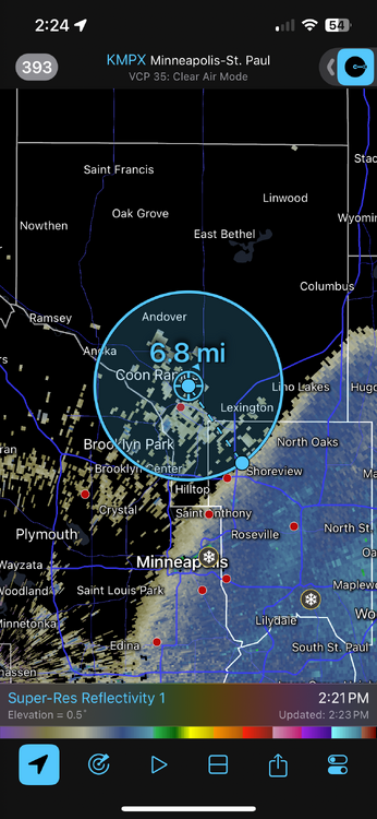
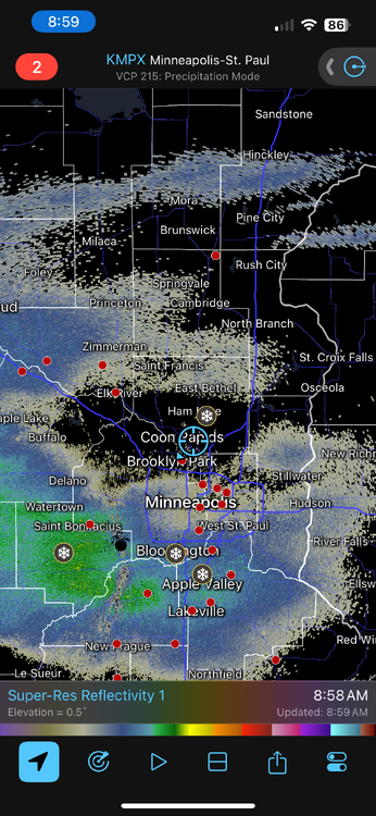
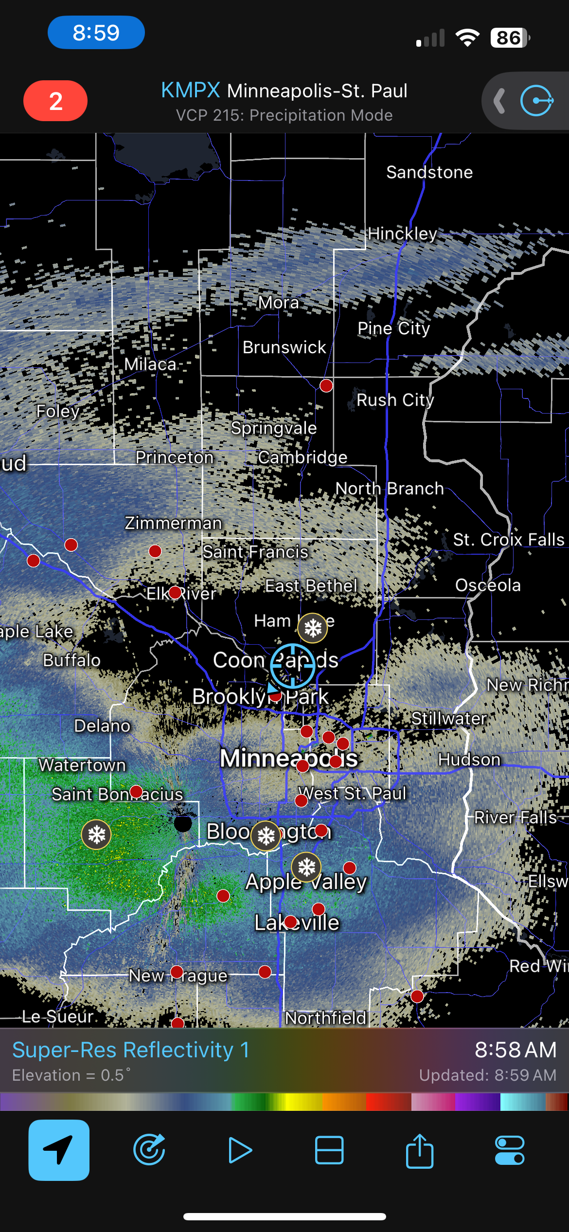
Little band of snow over the Twin Cities just blew up on reflectivity into a full on snow band. Must be some better forcing working its way towards us. Might end up with a little surprise if this holds up for a while.
. -
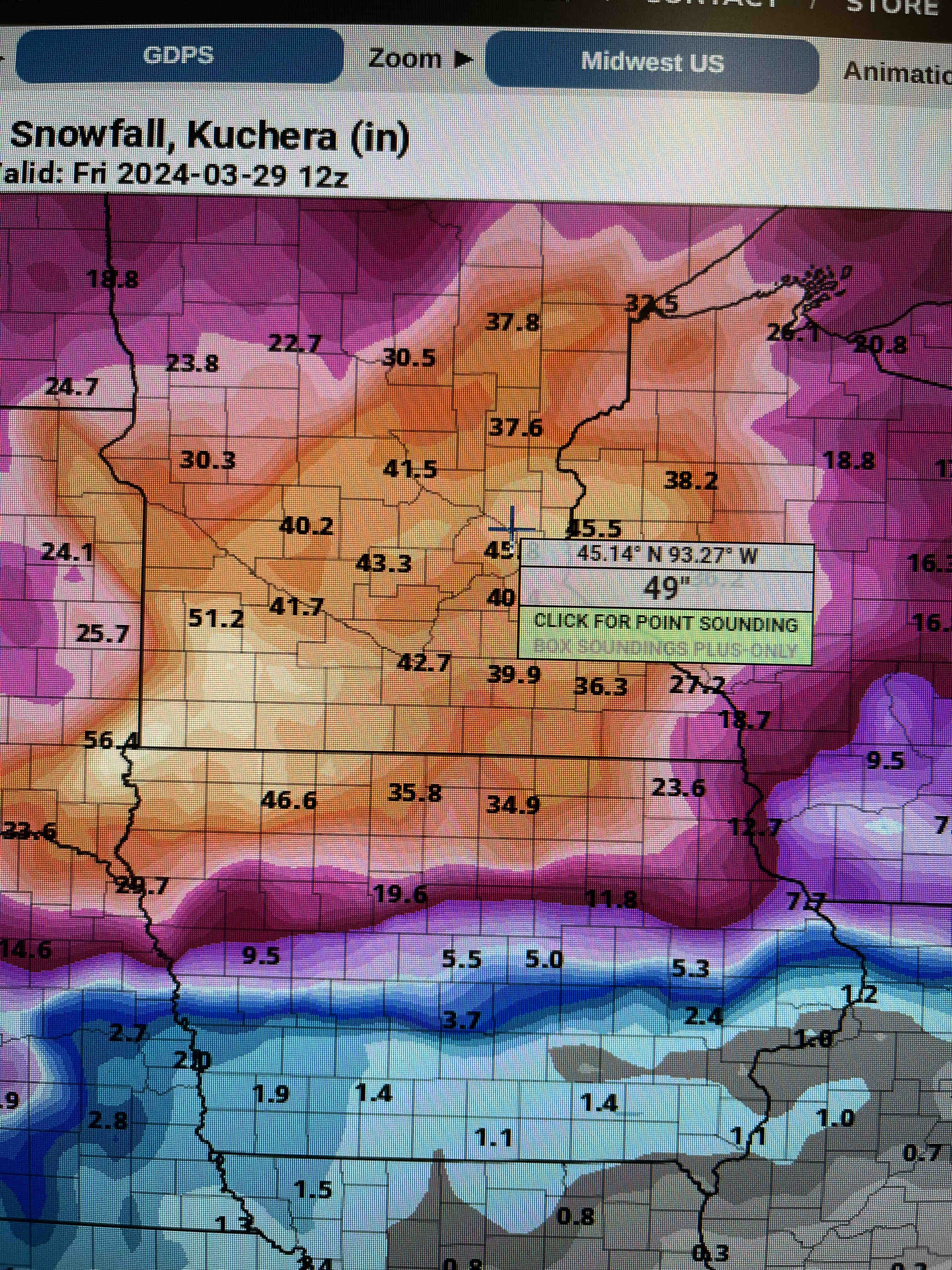
After receiving 90-100” last winter it’s no surprise that we are getting missed this year. I’m with ya though.
Even last year the north side got the short end of a lot of the storms. If the NWS got over 100”, the airport got 90”, I bet we got 80-85”. Still a lot, but it always amazes me how much of a difference those 10-20 miles across the metro can make for snowstorms.
.-
1
-
-
Getting some snow across the far southern suburbs in Prior Lake Minnesota. Looks like a general 1-2” for the twin cities.
Stuck in a dry pocket on the north side. Sometimes I really hate that I care…
.
-
3
-
1
-
-
5.5” imby? Probably a toss but it has my attention.
I’d honestly be happy if we squeaked out a few inches from this after it looked like a complete miss for us.
.-
1
-


March 2024 General Discussion
in Lakes/Ohio Valley
Posted
Also, how many times have we had a white Halloween and Easter and a green Christmas?
.