
mnchaserguy
-
Posts
145 -
Joined
-
Last visited
Content Type
Profiles
Blogs
Forums
American Weather
Media Demo
Store
Gallery
Posts posted by mnchaserguy
-
-
Gfs says we have another shot at breaking the all time snowstorm record as well as the all time season record. It might just snow until summer up here at this rate.
.-
 1
1
-
-
I know the chances of this happening are about 0.1% but still, you don’t see stuff like this around here very often.
.
-
 2
2
-
-
Looks like we’ll be riding the edge of rain/snow on this one. GFS puts 6-9” down here but it’s close. Either way nice to have some active weather to track.
Looks like the Euro is trending south towards the GFS solution which would put us in the heavier snow. Still could change but it seems like the NAM is the outlier right now. FWIW the GEFS mean snow also indicates its members favor the deterministic GFS solution.
. -
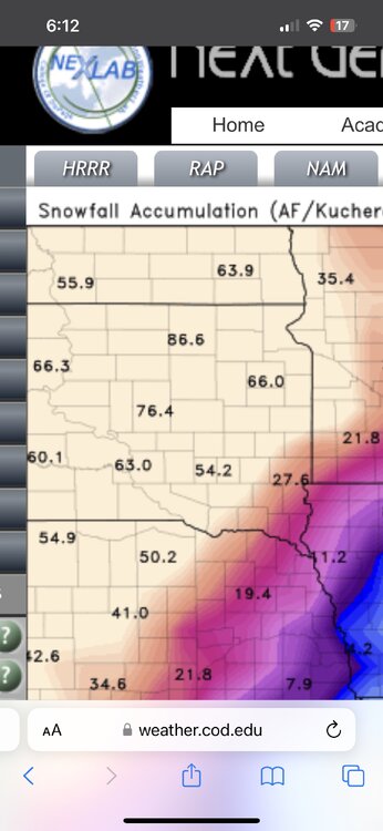
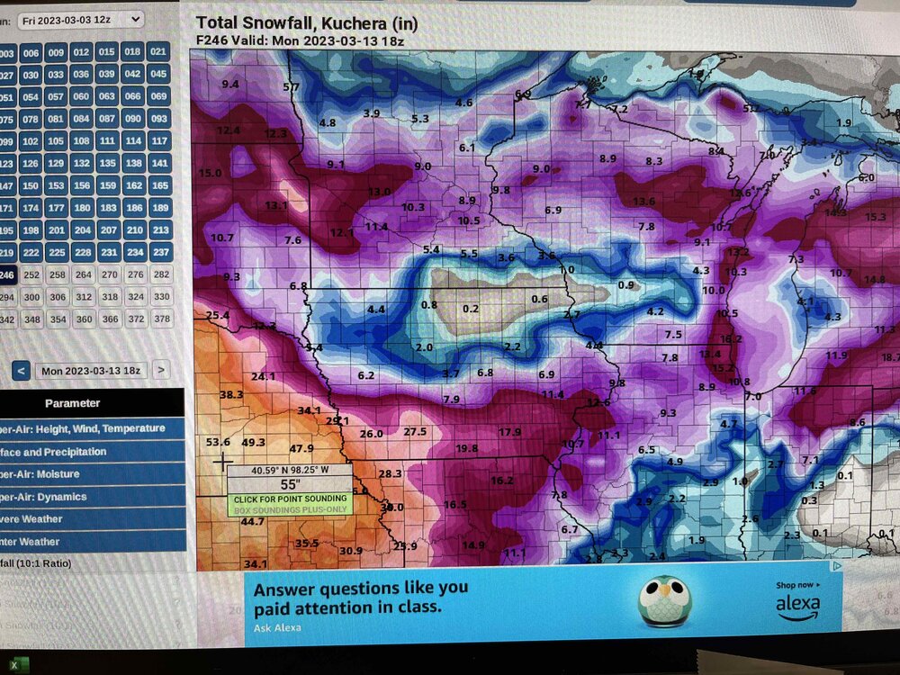
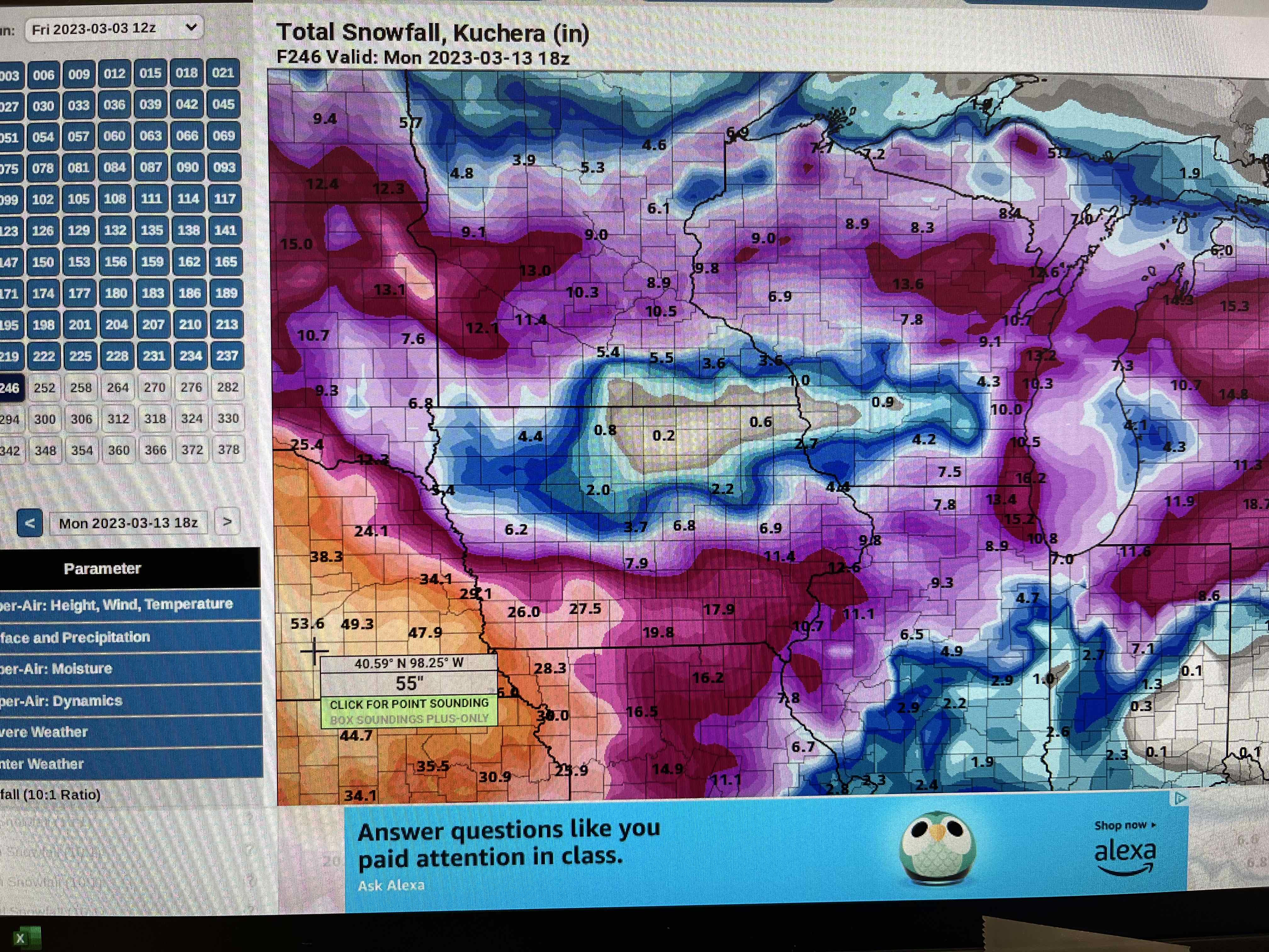
I found this pretty comical. 12z gfs has a phantom 55” snowstorm in Nebraska in about a week.
.
-
Nam and gfs are polar opposites for MSP for Monday. Gfs gives us snow and nam gives us rain. Euro is somewhere in between. Which one will be right? Who tf knows any more.
. -
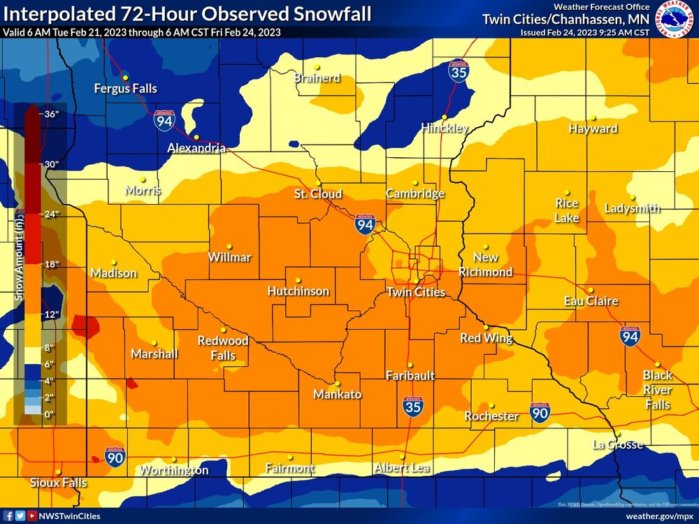
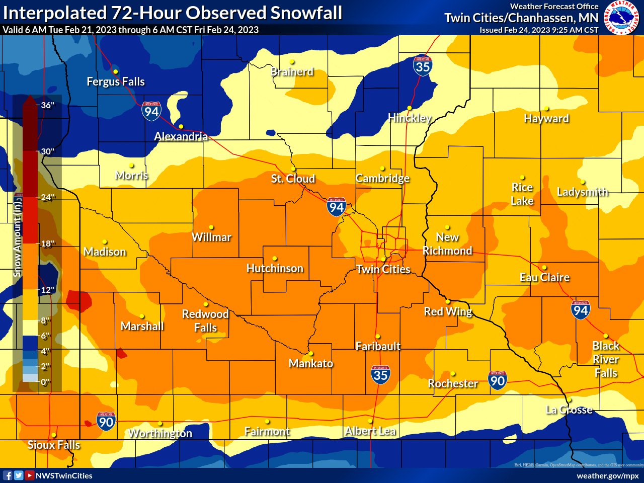
Looks like another decent storm to start the week next week. Nothing major but a solid WWA criteria storm the way it looks right now. A much bigger storm possible later next week. Sitting at 71.4” for the season at the airport. Need 27” to break the all time record. The models certainly want to give us a shot at that.
.-
1
-
-
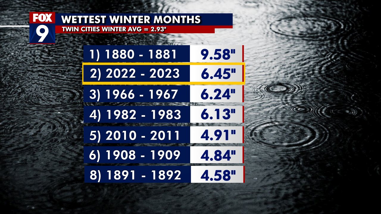
2nd wettest meteorological winter on record. Going to be interesting to see how this translates to spring flooding. It’s been a heck of a winter, however 1st place is on a whole different planet.

Jesus. I wonder that the 1880-81 winter was like. Do snow records go back that far?
. -
an admin banned someone without going through the warning system so now the precedent is set.
The precedent that pedos won’t be tolerated?
.-
1
-
 1
1
-
-
Sure looks like tonight’s storm is shifting north. I’ll be surprised if most of the metro gets more than 2” despite the WWAs in place.
. -
Kinda surprised MPX doesn’t have a WWA for the northern metro. Zone area forecast calls for 2-4” tomorrow for my county.
. -
Nice layer of ice this morning. Can’t even get the car back up the driveway right now. Gonna be a work from home day I think. The new pup will appreciate that.
.-
2
-
-
Upslope enhanced snowfall from north winds going up the Minnesota river valley bluffs?

I’ve said it in private before but I’m convinced there is weather control happening to keep MSP operating as normal as long as possible during snowstorms and the hole around the metro saturates from south to north. I have zero data to back that up but I will gladly wear my tinfoil hat until I can be proven otherwise. It’s either that or the urban heat island affect plays a larger role for snowstorms than I realize. No matter what, there always seems to be a hole around the metro when snow moves in.
. -
This is an A+ winter anyway you slice it.
It is. I just wish we could have spread the wealth a little more evenly on that last storm. That area got a 20” storm last winter while I got 6”. Seems to be a horseshoe floating around the south metro these days.
. -
Your area is rivaling annual record snows. Have some god damn self awareness
There was an 8”+ difference over the course of like 10 miles. Excuse me for being slightly annoyed about that, especially when it occurs on a seemingly regular basis.
.-
1
-
1
-
-
Cursed with 70” of snow on the season. Right
Thanks for the sarcasm. Love it.
. -
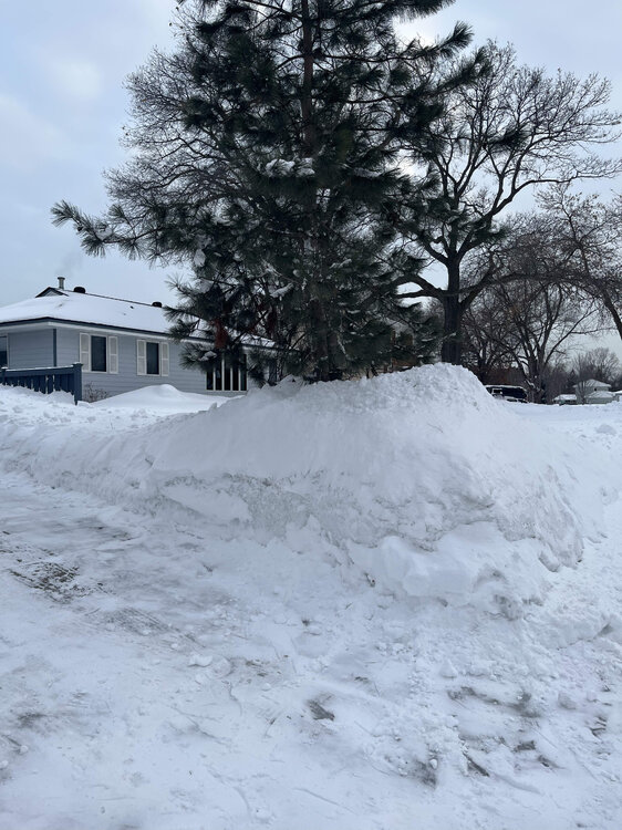
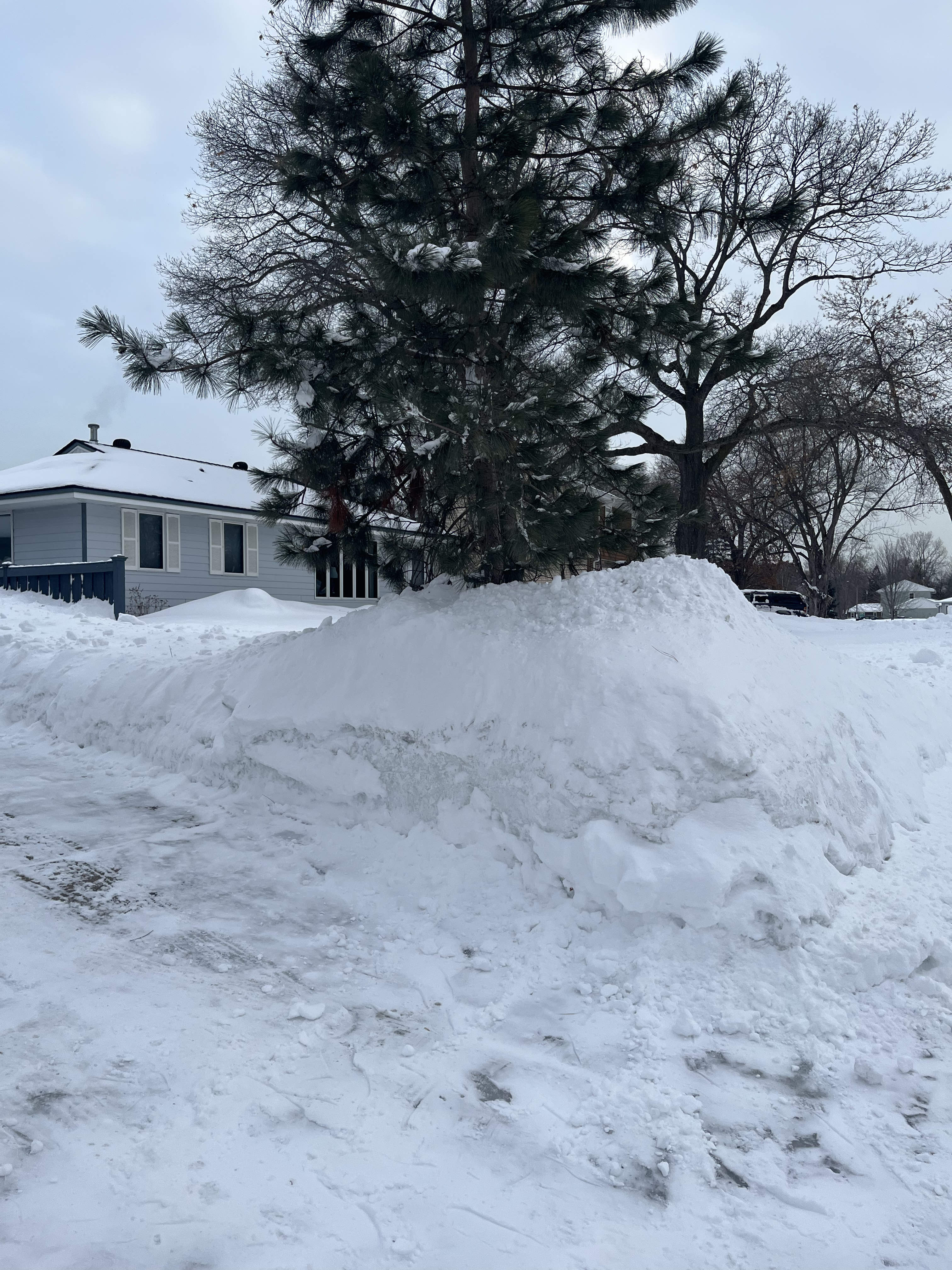
Pics never do it justice but the top of my snow pile is over 6’ tall. I can’t imagine how hard it would be to clear the driveway if we didn’t get that rain last week to wash some of the snow away.
.
-
3
-
-
Pretty broad area of 12”+
And I’m right in the middle of the hole in the north metro. I swear we’ve been cursed for a long time up here.
. -
Second largest February storm ever at MSP. If that weenie band of 18-20” in the southern burbs was 10 miles north this would have been a top 5 snowfall all time. Given the full evolution of the storm, it’s was incredible to witness all major global model lock into a solution a week in advance that more or less verified.
That same area got a 5 mile wide weenie band last year that gave them 20” while the airport got 12” and up here in Blaine we got 6”. Been a while since the north metro has won the snow total game.
.-
1
-
-
Was about to post this. I don’t buy that 19” report but the 15-17” seems plausible given that area saw good banding from both waves. It’s still snowing fat dendrites here and I bet we have 13-14”
It’s impossible to get an accurate measurement with the blowing and drifting. I measured over 20” in one spot and then 6” right behind it. I’m gonna split the difference and go with 13-14” for me, maybe more. Still snowing decently up here as well.
. -
There are some 16-19” reports starting to pop up in the central and south metro. I’m not sure I completely buy it but I guess the larger bands did favor the south metro more than the north. Maybe not a complete bust for everyone.
. -
The models are broken IMO. I don’t know how to fix them but they have all been quite bad for a long time.
. -
I'm not sure what you do as a forecaster right now.
Day after day prior to the storm we have excellent model agreement across the board showing a major, perhaps historic, storm. Even if you slow play the hell out of the messaging, eventually you have to alert the public to the potential. The modeling has been somehow horrendous but in lockstep.
I think MPX was conservative as long as possible. Unfortunately the models were still showing a historic storm by the time messaging needed to go out. What really sucks is the general public will never understand that.
. -
Unless I’m measuring completely wrong, I’m at 10” for the entire event. If it actually snows all the way until noon I might hit a foot. No matter what, this will not end up even being a top 20 event for me, let alone top 5 like it looked like a few days ago.
.-
 2
2
-
-
Closing in on an inch imby from the main event. It’s coming down pretty good right now. What part of town are you in? I think 8-10” additional is probably what my side of town will see.
I’m up in Blaine. We missed the bigger bands yesterday and the current band seems to be drying up on the north side.
.

March 2023 General Discussion
in Lakes/Ohio Valley
Posted
The Twin Cities continue to be a snow hole at the onset of a snow storm. I don’t know how to explain it…
.