
mnchaserguy
-
Posts
139 -
Joined
-
Last visited
Content Type
Profiles
Blogs
Forums
American Weather
Media Demo
Store
Gallery
Posts posted by mnchaserguy
-
-
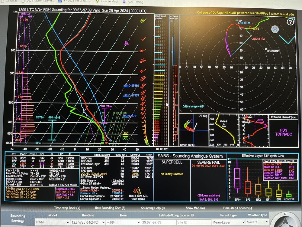
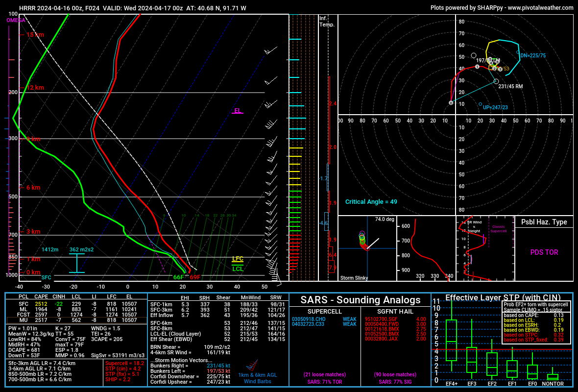
It’s the 84hr NAM. That’s all we need to know. Plus that sounding is a bit contaminated.
So much can change this far out, especially with earlier season events. The potential spread for Saturday is quite large. We first need to see how the next couple of days evolve, then focus shifts toward the potential for early initiation on Saturday.
I think most chasers (myself included) understand that things need to be taken with a grain of salt at this point.
. -
This is about as nice of a forecast sounding as you can get. What can go wrong.
.
-
Saturday is finally within range of the NAM and it is throwing out some big parameters across KS/OK. The dry line and warm front both look like good options. As long as things don’t go early, it could be a pretty big day. My biggest concern is storm motion. Forecast soundings showing bunkers right storm speeds at 40+ knots. That’ll make chasing difficult if those are accurate.
. -
I’ll be coming from Minneapolis on Friday so my plan is to chase the warm front Friday afternoon in Iowa. Now that it’s finally in range on the nam, central/southern IA looks to be where the warm front will set up Friday afternoon. Taken verbatim, the 12 nam shows an MCS developing across central Iowa with a tail end Charlie moving through a pretty good parameter space. That being said, this is only one solution several days out so it’s hard to know exactly what to expect right now. At this point, all I can plan on is leaving Minneapolis by 11:00 am and driving south to try to be in position for the afternoon. Friday could be impacted by convection from the night before, but right now Thursday looks to remain mostly capped. Even with parameters and moisture really ramping up after dark on Thursday night, most models look like they remain dry. I would think this would be a good thing for Friday so we don’t risk mid day convection ruining the atmosphere.
Saturday looks like a pretty solid day in the central plains. Dryline with deeper moisture in the warm sector with a strong jet streak overhead should lead to a good set up. Problem I see is some of the best parameters stay way south in southern OK, likely due to some early convection firing farther north. My current plan is to try to make it to KC on Friday night and head south to chase the dryline Saturday afternoon, possibly as far south as southwest OK if I have to.
Was hoping to chase Sunday but it looks like the system might be too far east for my liking by Sunday. Could be some potential right up next to the center of the low, similar to what happened in northwest IA last week. That would probably be a really conditional threat if anything.
.-
 1
1
-
-
It’s a little outside of the geography of this sub but I am planning on chasing Friday and Saturday. Friday in Iowa along the warm front and Saturday farther southwest along the dryline in Kansas or maybe Oklahoma. Been a long time since I’ve done a little multi day chase so I am pretty pumped about this weekend.
.-
5
-
-
Made the last second decision to play northwest IA thanks to the dry slot cleaning out just enough to get things going. I should have left the house an hour earlier. Missed the tors but still saw a lot of good rotation and motion. I’m really surprised this thing didn’t produce while I was on it. The 0-3km CAPE must’ve been zapped just enough to keep the lowest levels of the atmosphere from being able to finish it off. Oh well. Solid first chase of the season.
.
-
9
-
-
And of course, 0Z HRRR now cap busts SE IA despite a pretty sexy parameter space.

I don't give it a whole lot of credence given how much forcing ought to be present, but not exactly what I was hoping to see.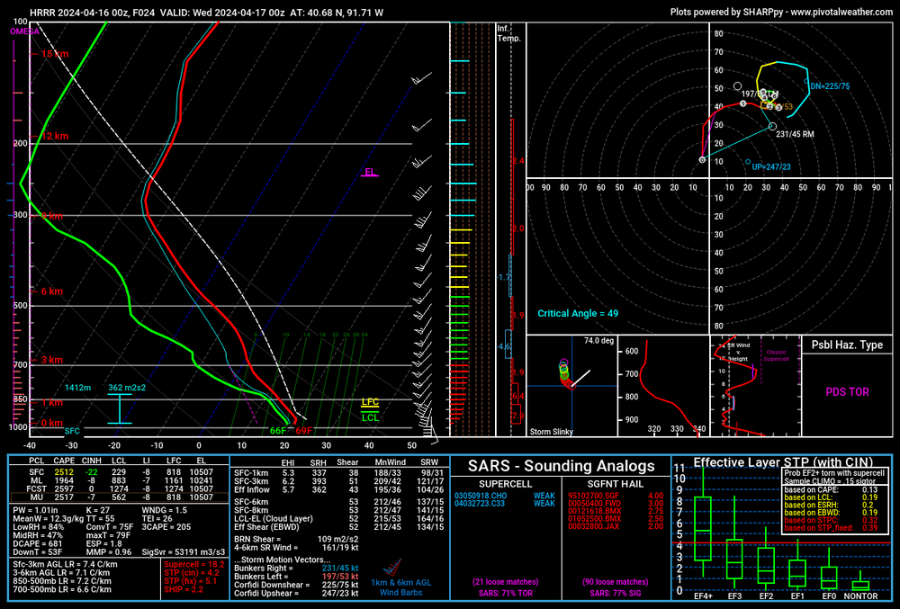
I wouldn’t call it a cap bust. Early precip is screwing up the heating and probably leading to some subsidence as well. Temps don’t rebound out of the 60s behind that initial band.
. -
I want to chase tomorrow but it looks really messy. An initial band of severe storms comes through Iowa early afternoon and mixes up the environment. Highly doubt anything substantial happens after that initial band comes through, unless you get way down to southeast IA or northern MO, which is out of range for me on a Tuesday. Hoping the 0z CAMs look more promising for the later afternoon. The early band may still produce a couple tors but it’ll be damn near impossible to know where or when to be on it to have a chance seeing anything.
. -
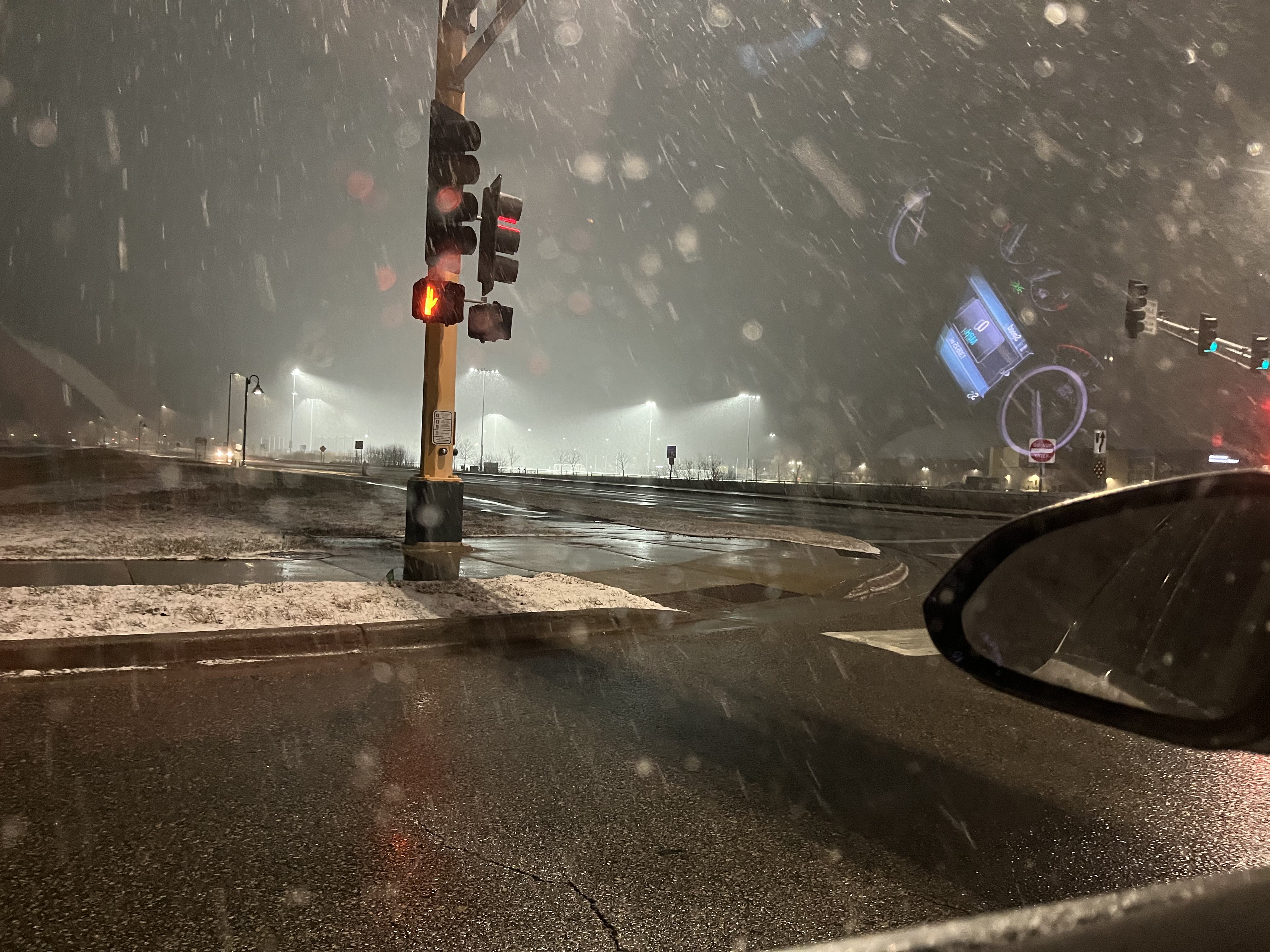
Surprise snow here in MSP this morning. Roads are just wet but I bet we will pick up a quick inch in the grass. It’s coming down about as hard as it has all winter.
. -
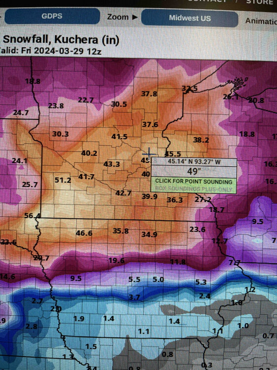
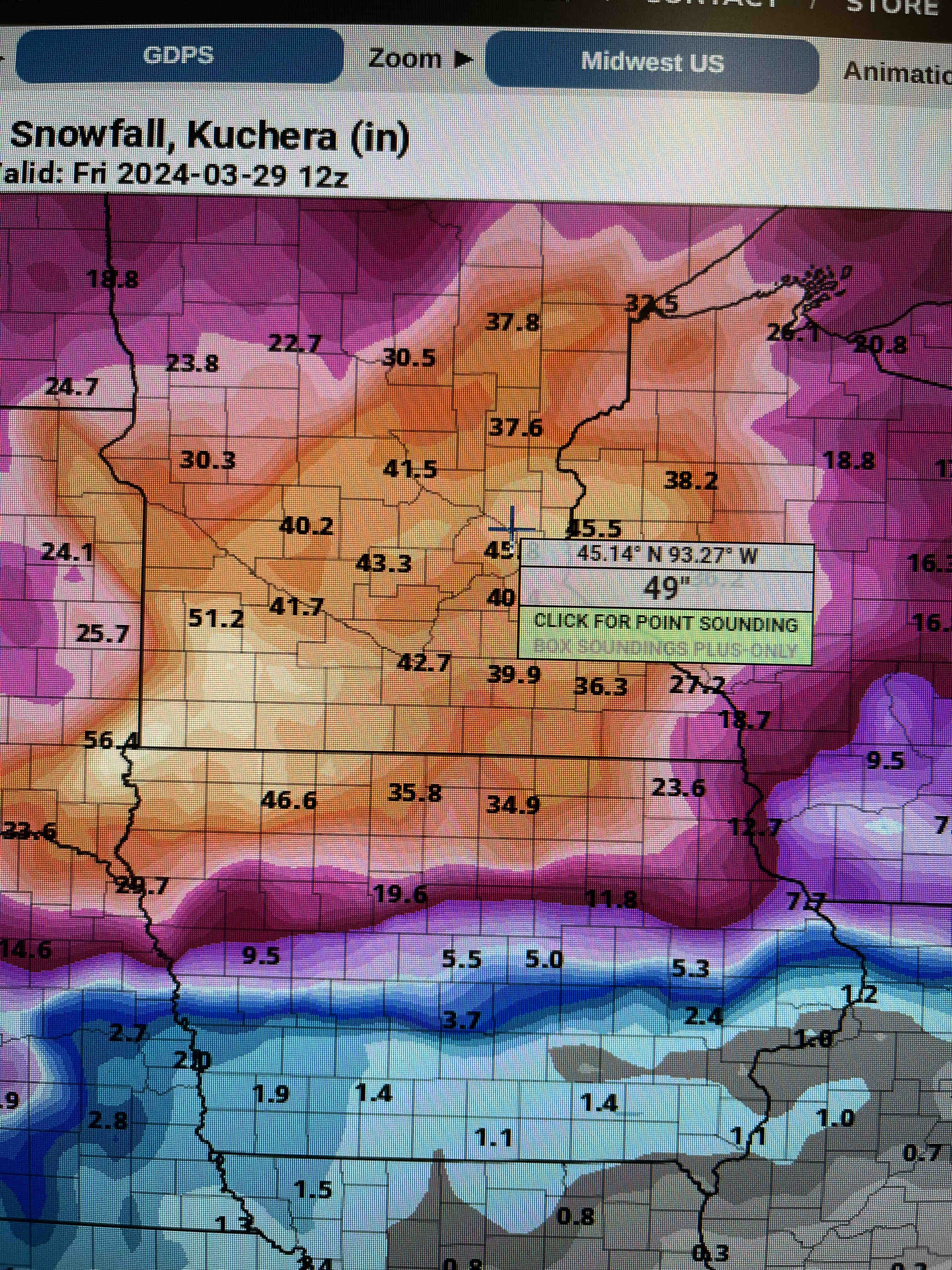
Allegedly we got 10” here in Blaine Sunday night/Monday morning. Combined with the 4” we got last Thursday and the 4-6” we will have by the end of today, we will be close to 20” here in the last five or six days.
. -
Absolutely puking snow. Roads are completely covered. Building up that late March snowpack. This storm has been awesome. Finally kicked the doldrums of nothingness we’ve been in for months.
Yep. Looks like MSP is in the sweet spot. The area of snow is just rotating right over us. The Duluth radar looks crazy too. North Shore is getting dumped on again today. Already well over a foot in Duluth and Two Harbors.
.-
3
-
-
It is snowing very hard at my house. Not very often we get all snow in 40-50 dbz returns around here.
.-
3
-
-
Sun starting to set, heavy returns incoming upstream. This is where we start stacking flake efficiently. It’s been steadily snowing all afternoon but probably only 2.5” accumulation. It’s been an awesome day of watching the snowfall with my kid.
That band moving up from the south is no joke. Should be fun to watch it when it gets here. It had some thundersnow for a while down by Rochester.
.-
2
-
-
You know it's gotta be snowing if the SPC puts out a mesoscale discussion for snow (MSP to Wisconsin, right now)
Can confirm from the middle of that MD that it is snowing pretty hard.
. -
Snowing pretty good here at the National Sports Center on the north side of MSP.
.
-
8
-
-
Bill Borghoff did the afternoon forecast discussion. He mentioned watches coming soon.
I saw that. I’m really surprised none of the WFOs have issued a watch yet.
. -
P&C was bumped up to 4.1” imby for tonight’s event. NWS must think the heavier band will setup over the twin cities. We shall see.
P&C is at 17” for the Sunday/Monday storm. Shocked it’s that high tbh. Models have been trending more frozen precip today but given the complexity of the setup I think it’ll be a nowcast type of storm.
MPX bumped up the zone area forecast for me in Anoka county up to 4-6” tonight. I’m real surprised no winter storm watches have been issued for this weekend anywhere yet.
. -
We won’t have a White Easter, snow this time of year doesn’t last long.
Willing to bet there is still snow on the ground by Easter around here in Minneapolis.
.-
1
-
-
I wonder how many times on record March 16-31 delivered more snow then December 1-March 15.
Also, how many times have we had a white Halloween and Easter and a green Christmas?
.-
2
-
-
Weenie post of the day courtesy of the Canadian
.
-
 3
3
-
 2
2
-
-
Looking more and more likely that our snow season gets in MSP is far from over. Guess we’ll just have to be happy to get precip in whatever form we get it.
. -
At this point my biggest concern is the complete lack of snow across most of central Canada. If things don’t change (and I don’t think they will) I bet the jet stream will shoot up well into Canada by the beginning of summer.
.-
 1
1
-
-
Watching our radar tonight has been fun. Lots of banding and random forcing going on. One final big band developing right over the heart of the metro.
.-
2
-
-
One of the more unique WWA and WSW combinations I’ve ever seen. Glad I finally got under the over performing band for a change.
.
-
3
-


4/25-4/28 Severe and Heavy Rain Threat
in Lakes/Ohio Valley
Posted
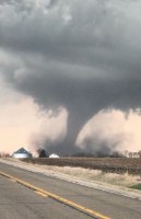
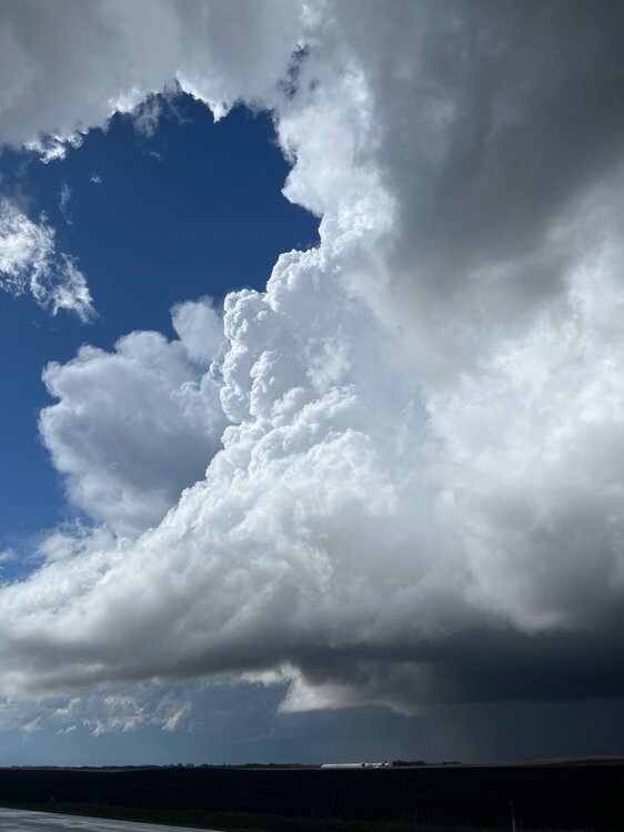
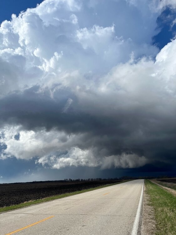
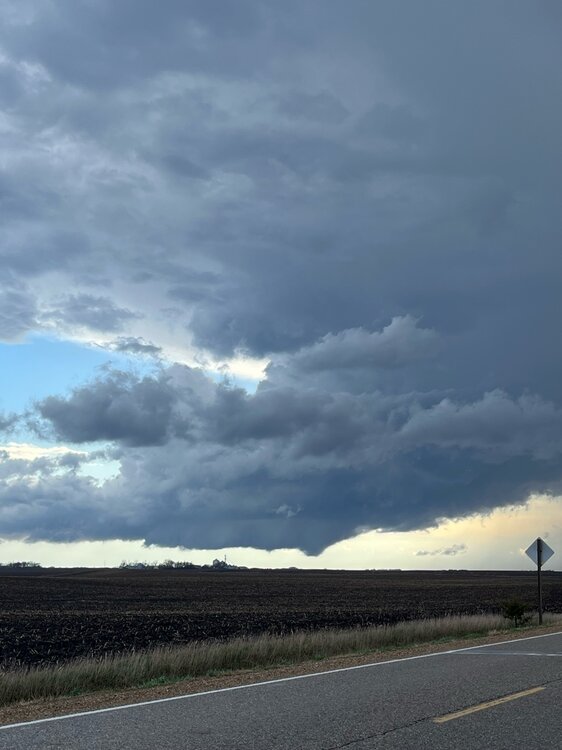
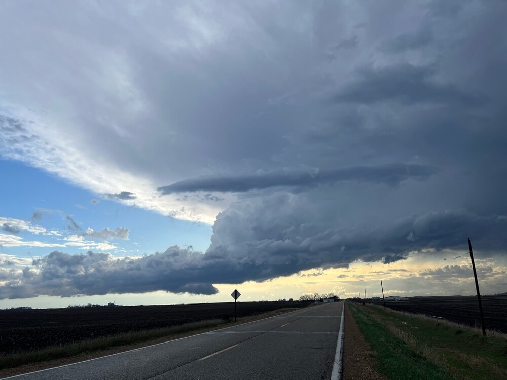
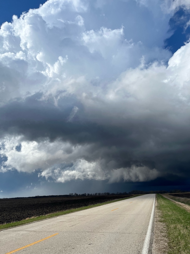
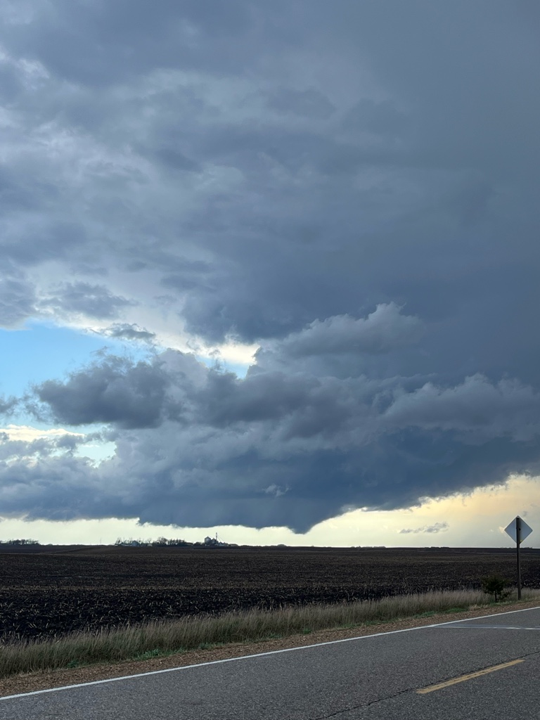
Managed to see two tornadoes in southern IA on Friday between Creston and Afton, IA. Both have been rated EF2. I also came into Osceola right after it was hit by what is the strongest (and also smallest) tornado of the group based on the damage surveys. Also included a screenshot of my location on radar. I was absolutely surrounded by tornado warnings, including being in three different warnings at once at one point.
.