

Wow
-
Posts
7,988 -
Joined
-
Last visited
Content Type
Profiles
Blogs
Forums
American Weather
Media Demo
Store
Gallery
Posts posted by Wow
-
-
4 hours ago, burgertime said:
I feel your pain! But hey at least it's warm where you're at. My climate here during the winter is a constant 34 - 38 degrees with rain and wind. Biking too and from work every day.
What the heck are you doing over there? Tracking snowstorms aren't the same knowing you're not in the game with us anymore. At least you came back for the model pbp's. BOOM!
-
 2
2
-
-
Already banned and deleted. When the mods and admins are weenies as well it gets fixed fast.
-
8
-
 2
2
-
 5
5
-
-
Just now, ForsythWx said:
18z FV3 Kuchera ☃️
That's just obscene. First a CAD induced storm, then the UL wraparound. Snows from overnight Sat/Sun into Tuesday morning
-
3
-
-
1 minute ago, +nao said:
How many winter storms have we had in the southern piedmont in the first half of December that are even close to what the models are predicting? For that matter how many winter storms in NC have been as big as what is being advertised?
Not since Dec '89
-
1
-
1
-
-
14 minutes ago, griteater said:
That was an unbelievably good run of the FV3...drops the backside wave in late and closes it off...big if true

Wow, yes this would keep it snowing around our neck of the woods for quite a while as the UL rolls just to the south of us. No longer would need CAD in place as it's making its own cold air. Thundersnow? Hmm
-
3
-
1
-
-
4 minutes ago, Queencitywx said:
I think we’ve potentially found your foot.
With this amount of precip forecast, it's looking good right now.

-
1
-
-
While waiting for the FV3 beyond 90, here's a trend loop. I love watching models discover CAD.

-
5
-
-
2 minutes ago, NC_WX10 said:
Much less precip for WNC. Looked juicy at 84 and then went to nothing
This will waffle around, no worries at this time. Anyway, it still a lot of precip, be it 1" or 3"
-
Southern trend my friends

-
6
-
-
2 minutes ago, DopplerWx said:
soundings dont look as good thru 84 for kclt though.
huh? Mid levels are like 3 deg colder in the mid levels.. not even close to a non-snow sounding
-
2
-
-
definietely colder at 90 per soundings for W piedmont
-
1
-
-
1 minute ago, DopplerWx said:
at 84 its about identical to 12z
looks juicier back west
-
1
-
-
GFS a bit colder at 78... snow breaking out over extreme N SC
-
1
-
 1
1
-
-
13 minutes ago, griteater said:
30 inches of clown snow for snowniner
Interesting that it's picking up a lee side minimum
-
1
-
1
-
-
12z GEFS snow totals individual panels. A lot more agreement for a big winter storm. Best chances still WNC.. still some members cutting north to hit the MA which would be an issue for eastern half of the state

-
2
-
-
Looks like an I-85 special
-
3
-
3
-
-
...and it has not trended north. The 50/50 low continued to trend stronger .. It's further south compared to prev run

-
7
-
 1
1
-
1
-
-
Guys, this is the FV3 at 96

-
2
-
2
-
-
Good to see the FV3 coming back south closer to yesterday's run
-
3
-
-
10 minutes ago, Orangeburgwx said:
No, I can't, only got a 20kb upload limit
use Imgur.com
-
1
-
-
2 minutes ago, Queencitywx said:
It’s not only the numbers, it’s the widespread support for big snow.
Indeed.. broad support for the double digit numbers. 6/20 is 24"+ in Statesville LOL
-
1
-
-
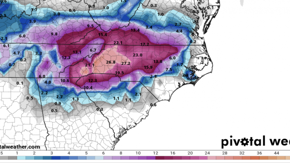
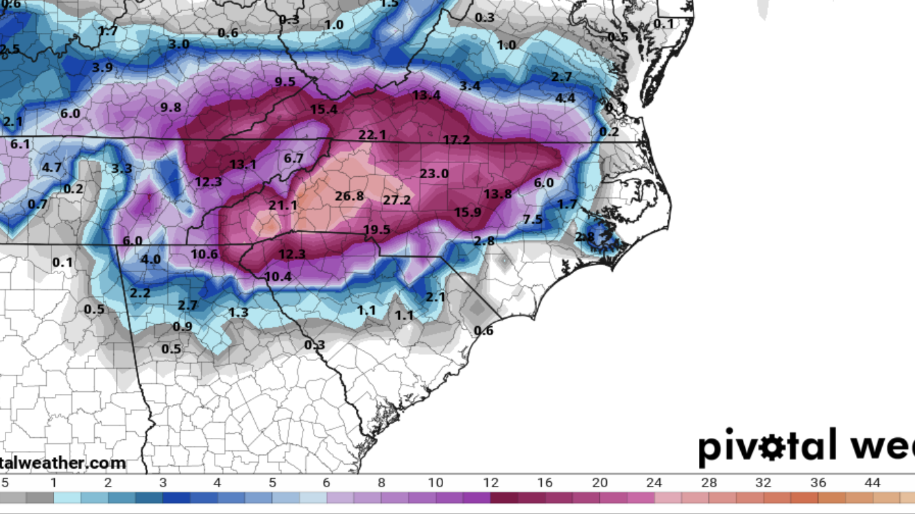
18z GEFS mean snowfall:
CLT: 9"
HKY: 17"
SVH: 15"

-
1
-
-
Quite a few wild snow maps out of the 18z GEFS

-
7
-
1
-
-
8 minutes ago, Queencitywx said:
Snow numbers up, too.
Yes, since 12z. Similar to 6z

-
2
-
December 8-10, 2018 Winter Storm
in Southeastern States
Posted
Yup.. pushing an AVERAGE of 2.5" QPF over CLT