

Wow
-
Posts
8,046 -
Joined
-
Last visited
Content Type
Profiles
Blogs
Forums
American Weather
Media Demo
Store
Gallery
Posts posted by Wow
-
-
GFS definitely trending toward its successor WRT the upper level low swing through early Tuesday
-
1 minute ago, wncsnow said:
Through 90 there is less total precip over WNC
No, it's not. It's pretty much on par with the prev run thru 96
-
Just now, Lookout said:
well the 0z gfs holds in showing much warmer temps. If our suspicions are correct, this could be an epic bust on it's way out the door. Nam is up to 8 degrees colder than the gfs over north ga.
It's the GFS, and at this range what's the surprise?
-
The northern s/w is less strung out and more defined like the NAM... that's likely given the resolution. I think the late phase and cutoff UL solution is looking better.
-
Pretty minor differences at this range.. within 20-30 miles by the looks of it.. overall setup is similar
-
At 72, the low is in the same place.. Minor differences.. perhaps a hair more north with the precip sheild
-
The ICON, which has no knowledge of CAD, has trended back south. Gives the mtns a real shellacking.
-
 1
1
-
-
1 minute ago, WidreMann said:
Instead it's an 84 hour NAM fantasy storm.
This is preferred.
-
 1
1
-
-
NAM builds in a 1040mb banana high over the OH valley to the NE. You can't ask for anything better. It's like an old 384hr GFS fantasy storm coming true.
-
10
-
-
1 minute ago, WidreMann said:
It then rapidly builds the cold air in as the storm approaches. I'll take that. I'll also echo Wow's sentiments about the NAM.
The wonders of low dewpoints as precip builds in. God bless CAD.
-
7
-
-
Oh you guys freaking out about the NAM... lol
-
1
-
4
-
 1
1
-
-
GEFS TREND!

-
6
-
 1
1
-
-
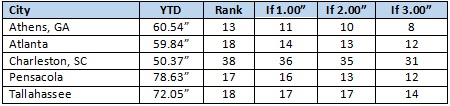
14 minutes ago, donsutherland1 said:
A moisture-laden storm will bring heavy precipitation to parts of the Southeast and Lower Middle Atlantic region during the December 9-11 period. Cities such as Atlanta, Charleston, Pensacola, and Tallahassee could pick up 2" or more precipitation.
As a result, 2018 would rank among the 15 wettest years on record for a number of those cities.
Farther north, the pattern remains consistent with the composite 500 mb patterns that have seen significant accumulations of snow in parts of the Carolinas and Virginia. Further, the guidance has gradually moved into increasing consensus for a moderate to possibly significant snowfall in such cities as Asheville, Charlotte, Greenville-Spartanburg, Raleigh, and Roanoke. With cold air damming likely to precede the storm and a strong ridge likely to block it from turning sharply up the Coast, my confidence in a track favorable to the Lower Middle Atlantic region and parts of the Southeast has continued to increase.
Consistent with many of the notable snowstorms to affect this region, accumulating snow will likely remain south of the Mason-Dixon Line. There is also a possibility that the accumulating snow remains south of Washington, DC and its nearby Virginia suburbs.
The Don has spoken. Thank you, Don.
-
1
-
-
Just now, JoshM said:
6:30pm EST Dec. 5: NCEP data issues are causing delays in some model products.
Maybe that's correlated?
There's just too much awesomeness. Good safety measure.
-
1
-
-
7 minutes ago, beanskip said:
Look, it’s time to be real on this storm. I know we have all become experts on hedging and caveats and flies in the ointment. But I go back the old Wright Wearher boards 20 years ago and we have never, EVER seen a storm modeled like this. Consistent, run after run depiction of a historic event. Three inches of QPF paired with a classic CAD? Yes, the features will be better sampled in a day but I really don’t think Lucy can pull away the football on something like this. Even if the QPF is cut in half it’s still a monster. Even if the CAD is overstated by 100 miles, a large area will see more than a foot.
Bottom line: anything can happen, but I had to eventually wrap my head around a Cat 4 October hurricane and I wish I had accepted the inevitable sooner.
This thing is coming.
Get your ass back in NC!
 Having you and burger away from something as potentially memorable as this one is an injustice!
Now if I can get Robert posting on here again...
-
11
-
3
-
 1
1
-
-
4 minutes ago, MillerA said:
18z Euro
Check out @RyanMaue’s Tweet: https://twitter.com/RyanMaue/status/1070483217562681344?s=09
The r/s line is even a bit more further south than the FV3
-
3
-
-
1 minute ago, Queencitywx said:
GEFS is gonna have another stupid high mean
Yup.. pushing an AVERAGE of 2.5" QPF over CLT
-
1
-
1
-
-
4 hours ago, burgertime said:
I feel your pain! But hey at least it's warm where you're at. My climate here during the winter is a constant 34 - 38 degrees with rain and wind. Biking too and from work every day.
What the heck are you doing over there? Tracking snowstorms aren't the same knowing you're not in the game with us anymore. At least you came back for the model pbp's. BOOM!
-
2
-
-
Already banned and deleted. When the mods and admins are weenies as well it gets fixed fast.
-
8
-
2
-
5
-
-
Just now, ForsythWx said:
18z FV3 Kuchera ☃️
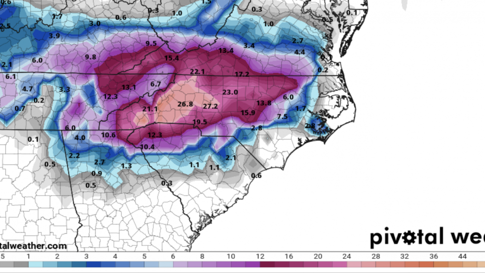
That's just obscene. First a CAD induced storm, then the UL wraparound. Snows from overnight Sat/Sun into Tuesday morning
-
3
-
-
1 minute ago, +nao said:
How many winter storms have we had in the southern piedmont in the first half of December that are even close to what the models are predicting? For that matter how many winter storms in NC have been as big as what is being advertised?
Not since Dec '89
-
1
-
1
-
-
14 minutes ago, griteater said:
That was an unbelievably good run of the FV3...drops the backside wave in late and closes it off...big if true

Wow, yes this would keep it snowing around our neck of the woods for quite a while as the UL rolls just to the south of us. No longer would need CAD in place as it's making its own cold air. Thundersnow? Hmm
-
3
-
1
-
-
4 minutes ago, Queencitywx said:
I think we’ve potentially found your foot.
With this amount of precip forecast, it's looking good right now.

-
1
-
-
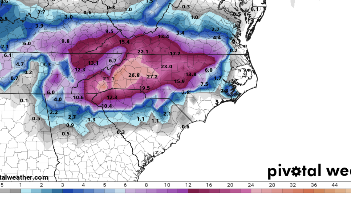
While waiting for the FV3 beyond 90, here's a trend loop. I love watching models discover CAD.

-
5
-
December 8-10, 2018 Winter Storm
in Southeastern States
Posted
Yep, and I've always noticed the UL progression most always trends stronger at the last minute with a cutoff with this big snowstorms.. always the last piece of the puzzle