

RU848789
-
Posts
4,002 -
Joined
-
Last visited
Content Type
Profiles
Blogs
Forums
American Weather
Media Demo
Store
Gallery
Everything posted by RU848789
-
Some 6Z models backed off on precip/snow, but not the Euro/GFS, at least, and many forecasters rely on those two...also could just be a blip, so would imagine no forecast changes at this late point unless some big changes at 12Z...
-
Didn't notice anyone having posted the NWS maps, so posting them below along with the map of warnings/advisories. Didn't do too badly last night, especially with the prediction on the NWS increasing snowfall amounts at 4 am. Have fun kids - and make sure you shovel by the end of the storm if you get wetter/slushier snow, because that stuff will freeze solid overnight and will be there all week.
-
That's how you know I'm old, lol, thanks...
-
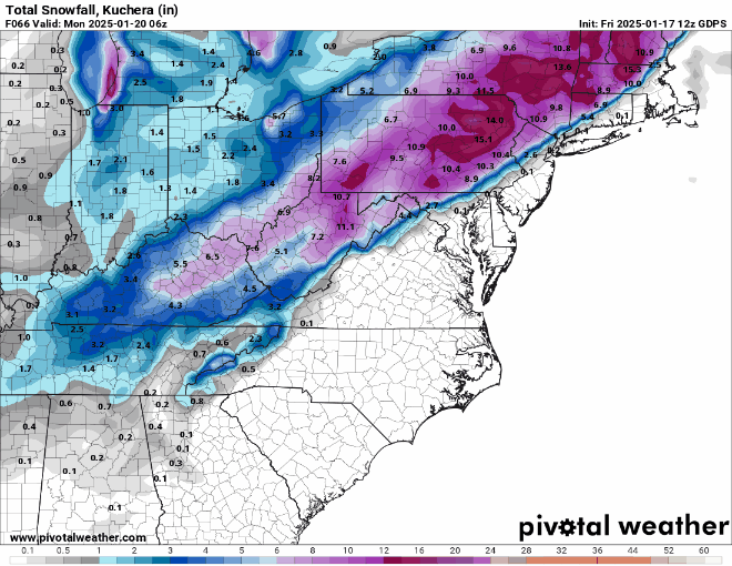
Just for giggles, given the increase in snowfall for many models, as well as the broader coverage with more snow and less rain from 95 SE to the coast (at least north of Toms River), I'm expecting the NWS to continue increasing snowfall totals. I'd go for 4-6" within 10-20 miles of 95 from Philly to NYC and for Monmouth County N of 195, with 2-4" for almost all of the rest of NJ, except maybe 1-2" for most of Cape May County and the NJ coast up to LBI. I would also keep the 6-8"+ area NW of 95, but probably move the 6" line SE 10-15 miles to maybe West Chester to New Hope to White Plains and I would have all of LI at 4-6", except eastern Suffolk at 3-4". My guess is that this would mean warnings for the 95-adjacent counties from Philly/SNJ up through NYC and probably advisories for Mommouth, Ocean, SE Burlco and maybe Cumberland, but not Atlantic/Cape May; guessing LI might be 4-6" advisories but not warnings, but close call (like for Middlesex/Mercer, where warning criterion is 6" vs. 4" for counties south of 276/195, so the warnings would make sense for SEPA/SNJ. Been wrong before on guessing NWS moves before, but I find it fun to guess.
-
And the CMC's failure is complete...
-
Forgot to post this (from my FB this afternoon): Time for my guesstimate for our house in Metuchen: going with 5.1", which is a bit above the model consensus (and my NWS point-and-click forecast is 4.3"), as I'm riding the Euro AIFS. I don't do storm forecasts, since I'm not a pro and I have no mapping skills. I just comment on other people's forecasts, lol.
-
Wow, the NWS has already bumped snowfall amounts up a bit along 95 and about 1" cross the board SE of 95 to the coast in NJ and they explain below how this is due to the early 0Z models, as discussed above. Area Forecast Discussion National Weather Service Mount Holly NJ 901 PM EST Sat Jan 18 2025 -- Changed Discussion -- Meanwhile near the I-95 corridor, this is where the forecast will be the trickiest in terms of Ptype. With temperatures right around if not just above freezing here as the precip begins, it may actually start as rain before turning over to snow as dynamic and evaporational cooling effects take hold. Then, as the low tracks up the coast through the day, a mix with or change back to rain or sleet may occur in the afternoon for a time before any mixing flips back to snow before ending Sunday evening. A Winter Weather Advisory was issued for this area. However, the early signals from the 00Z guidance suite tonight suggests that the amplification will be less than previously anticipated so this would result in a potentially weaker system, leading to more snow further south and east. With this being said, have subtly upped forecast numbers by about an inch or so across the coastal plain early this evening. Considering this, may have to further expand Winter Weather Advisories/Winter Storm Warnings further south and east, but we`ll leave that for the mid-shift to handle in the coming hours.
-
Amazing consensus at 0Z for the meso/hi-res models I've seen for at least the Philly-NJ-NYC region...NWS is likely going to raise accumulations SE of 95 based on these unless we see something odd with the globals... The NAM shows a general 4-6" event for literally everyone except 2-4" for Cape May and 6-8" for NYC and NE-ward The NAM 3km (high res) shows a general 3-6" even everywhere except for SENJ south of Toms River, which get 1-3". The HRRR shows a 4-6" event for almost everyone, except 2-4" for SENJ south of Toms River The RAP shows a 4-7" event for everyone, except 2-4" for AC to Cape May. The HRW-FV3 (will be the new NAM someday) shows a 4-7" event for everyone, except 0-4" for SENJ south of Toms River
-
Been telling people, especially those who get some mix/slush in their snow pack, to shovel during the event and right after it or else they're going to have a rock solid pack in the morning and yes the salt on the streets will melt some of the snow to make it slushy and that piled up mass will freeze solid wherever the plows leave it - could make tight city streets a nightmare.
-
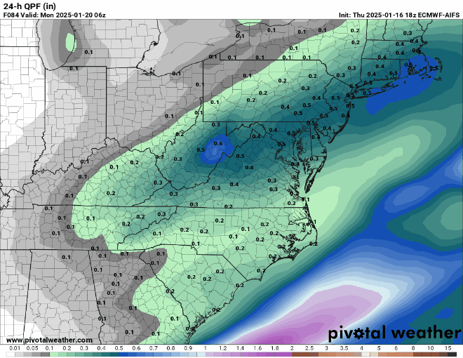
Here's the precip field; of course verification awaits (which is highly likely overall - there are always parts of a forecast that don't work perfectly for every model), but this is impressive
-
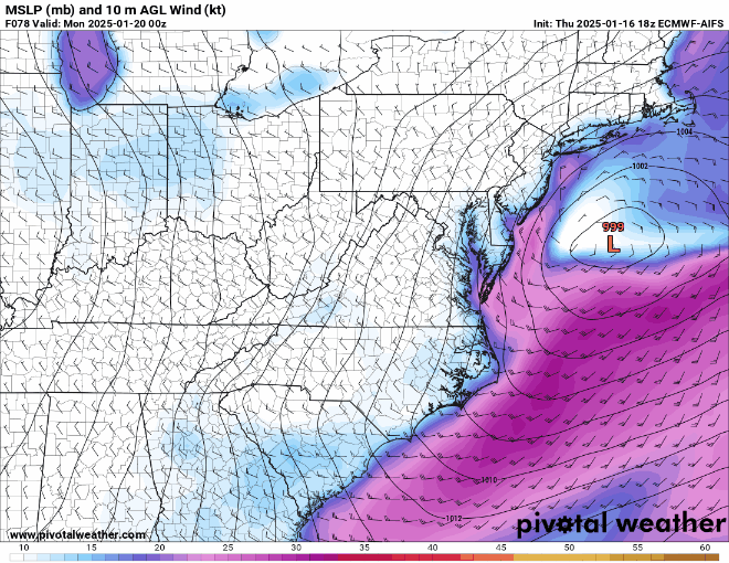
Hands down the best performing model for this event, based on memory, so I was curious and made these two GIFs of the surface low placement at 0Z Sunday and the 24 hour precip field through 06Z Monday and the consistency over 8 runs is astonishing and iirc, this consistency goes back 4-5 days.
-
Great, thanks!
-
Hey - I know you're the Euro AIFS snowfall map guy - have you posted an updated version? Thanks. I couldn't figure out how to do a search for your posts - used to be easy, maybe they changed how that's done.
-
@donsutherland1- hey Don, I recall you recently posted about significantly increased chances for NYC (and I think other 95 cities) to get major snowstorms during a regime shift with the cold and high latitude blocking relaxing (and other shifts), but I couldn't find it. Would any of that be in play for 1/24-25 (I see some signals on some ensembles)? It's obviously warming up by then and the latest forecast I saw was for the NAO to go positive around then. TIA.
-
Why oh why is anyone looking at the HRRR beyond 18 hrs? It's crap beyond then. I think it was the little 1/8 SNJ storm where the HRRR was showing 4-5" at ~24 hours out; most got <1". There are other examples.
-
This storm is no longer in fantasy land as we're now within 4 days of the start of the event in Texas. The CMC has been on this for days and the Euro/GFS are also on it, so even the NBM is showing a decent snowstorm. Crazy for this region. Houston's biggest snowfall ever was 20" in Feb 1895 and so was New Orleans's with 8.2", but they haven't had measurable snow in 15 years. https://www.nola.com/news/weather/snow-day-new-orleans/article_93ca617c-d354-11ef-ac9d-dfa183f2d62b.html .
-
NWS-NYC finally corrected their map and reissued. No longer completely inconsistent with Mt. Holly's map...and Mt. Holly just put out the regional map which I like...
-
Thanks although it's still wildly inconsistent with the Mt. Holly map in NNJ - it's like they grafted the new OKX map onto the old Mt. Holly map. They need to do better.
-
The NWS NYC map below makes no sense as there are watches up for 5-8" for much of the CWA...and obviously no collaboration between offices...Mt. Holly must be factoring in high ratios NW of 95
-
It's supposed to be rain at 12Z Sunday (7 am EST) as the cold air hasn't moved in yet. And stop looking at the 48 hr HRRR, the one that predicted 6" for that little SNJ 1" storm around 1/9.
-
Been snowing lightly off and on for a few hours and we have a decent coating of about 1/4" on all surfaces, given how cold it's been. Could be some slick spots out there. Nice surprise as I wasn't expecting much.
-
Great trends today and some thoughts looking ahead. Nice to see the NWS and other forecasters are now all playing up the snowfall potential as expected based on those trends, with the NWS now calling for a general 2-4" snowfall for everyone along and NW of 95 through 7 pm Sunday (noting there will be more to come) except maybe just 1-2" towards the coast (especially SENJ), but also noting that more is possible than that and less if the Euro is right, plus they acknowledge the risk of mixing/rain up to 95 as shown on the CMC.Lee Goldberg also has just about everyone at 2-4", with 1-2" south of Toms River and for far NW areas (Poconos/Catskills), but he also noted that there will likely be some 4-6" amounts, most likely from NYC on NE-ward but maybe even back towards CNJ. Precip looks like it will start by 1 pm towards Philly/SNJ (where game impacts are looking much more likely than yesterday) and by 3-4 pm in CNJ/NYC and will continue with temps likely falling into the 20s and precip going until 1-3 am Monday. Whatever accumulates will be with us through next week with the bitter cold coming. In addition, as many have discussed, there's an increased likelihood of snow ratios >10:1 with the snowier solutions, which are more likely to have good lift/supersaturation/crystal growth in the DGZ, as well as not suffering from column melting/aggregation with very cold column (except for CMC style outcomes where precip type is in question or at least falling snow could be very wet and lower ratio). https://forecast.weather.gov/produc...&format=CI&version=1&glossary=1&highlight=off National Weather Service Mount Holly NJ 354 PM EST Thu Jan 16 2025 .SHORT TERM /FRIDAY NIGHT THROUGH SUNDAY NIGHT/... From here, forecast guidance varies greatly and ultimately will determine what will occur Sunday afternoon into Sunday night. If the track of the low is close enough to the coast, a large portion of the region is likely to observe accumulating snowfall (similar to what the 12Z/GFS depicts). If the track of the low is suppressed further south and east (similar to the 12Z/ECMWF), then accumulating snow may only be confined to coastal areas. Whereas if the track of the low, hugs the immediate coastline, then the most significant snows will be focused north and west (depicted by the 12Z/Canadian). Regardless of the variance in global guidance, have seen an increase in overall QPF values and in snow probs. Thus, there is an increase in forecaster confidence that accumulating snow is on the table Sunday afternoon/evening especially since cold air will be advecting in from the northwest. So with this being said, the greatest potential for higher accumulations are for areas along the I-95 corridor and points north and west where the initial forecast calls for 2-4" of snow through 00Z Monday. Lesser amounts upwards of 1-2" are forecast near coastal areas through the same timeframe. Obviously, a lot can change over the next 60-72 hours as we obtain more hi-res/short range forecast guidance and storm total snowfall covers the `full duration` of the event, so stay tuned for the latest details to the forecast over the coming days!
-
Thanks!!
-
You are the man with the AIFS snow maps, so, please? If not out yet, it shows a general 0.3-0.5" of QPF with temps at about 32F to start for most but dropping into the 20s, so ratios could easily exceed 10:1 (3-5" at 10:1 or maybe 4-7" with good ratios) if we get good snow growth, given a likely cold column for most of the event. Verbatim.
-
Thanks, as always. Do you (or maybe @bluewave) know when was the last time we had below normal temps for both Dec/Jan? Feels like many years, but I don't track temps closely.


