RedSky
-
Posts
17,595 -
Joined
-
Last visited
Content Type
Profiles
Blogs
Forums
American Weather
Media Demo
Store
Gallery
Everything posted by RedSky
-

E PA/NJ/DE Summer 2025 Obs/Discussion
RedSky replied to Hurricane Agnes's topic in Philadelphia Region
A balmy 62F with dark November like sky and light rain -
E PA/NJ/DE Summer 2025 Obs/Discussion
RedSky replied to Hurricane Agnes's topic in Philadelphia Region
June 15th high temp 60.1F -
E PA/NJ/DE Summer 2025 Obs/Discussion
RedSky replied to Hurricane Agnes's topic in Philadelphia Region
Rain and 59F Merry Christmas and Happy new Year -
E PA/NJ/DE Summer 2025 Obs/Discussion
RedSky replied to Hurricane Agnes's topic in Philadelphia Region
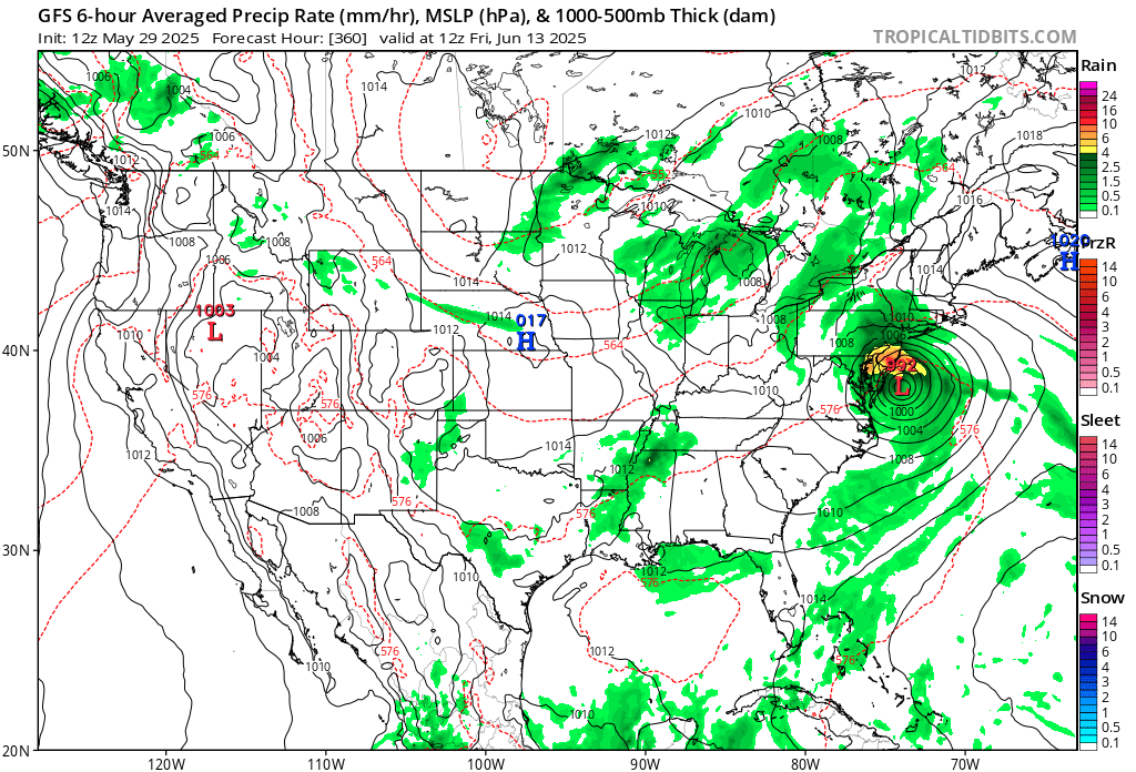
GFS is horrific for Saturday through Tuesday clouds showers and 10F or more below normal As if May wasn't bad enough for the people on weather suicide watch In other news the farmers replanted corn crops are in danger the ground is mud and can't recover -
E PA/NJ/DE Summer 2025 Obs/Discussion
RedSky replied to Hurricane Agnes's topic in Philadelphia Region
How did the Phillies go from the 2nd best record to possibly the worst looking club in baseball in two weeks I doubt they could beat a boomer softball team now -
E PA/NJ/DE Summer 2025 Obs/Discussion
RedSky replied to Hurricane Agnes's topic in Philadelphia Region
Endless rains five weeks worth never seen this. Only a three day break next Wed-Fri then another round. I'd sacrifice a kidney for a new drought -
E PA/NJ/DE Summer 2025 Obs/Discussion
RedSky replied to Hurricane Agnes's topic in Philadelphia Region
Not needed torrential rain great job having a flood watch when the models were not enthused -
E PA/NJ/DE Summer 2025 Obs/Discussion
RedSky replied to Hurricane Agnes's topic in Philadelphia Region
We G3 right now under the bright sun lol -
E PA/NJ/DE Spring 2025 Obs/Discussion
RedSky replied to PhiEaglesfan712's topic in Philadelphia Region
Nothing going on right now with the aurora possible next active phase is 11pm-2am Not sure it matters sky is smoky as hell -
E PA/NJ/DE Summer 2025 Obs/Discussion
RedSky replied to Hurricane Agnes's topic in Philadelphia Region
Clear breaks in the sky aren't blue but hazy white from smoke -
E PA/NJ/DE Summer 2025 Obs/Discussion
RedSky replied to Hurricane Agnes's topic in Philadelphia Region
The smoke is moving in this evening to obscure sky viewing lol -
E PA/NJ/DE Summer 2025 Obs/Discussion
RedSky replied to Hurricane Agnes's topic in Philadelphia Region
The sky would be lighting up with the northern lights like last October right now but alas it's daytime no way of knowing we get these parameters at night. -
E PA/NJ/DE Spring 2025 Obs/Discussion
RedSky replied to PhiEaglesfan712's topic in Philadelphia Region
12.40" final May total -
E PA/NJ/DE Spring 2025 Obs/Discussion
RedSky replied to PhiEaglesfan712's topic in Philadelphia Region
Back at the homestead missed that round of heavy showers only .20" 12.30" -
E PA/NJ/DE Spring 2025 Obs/Discussion
RedSky replied to PhiEaglesfan712's topic in Philadelphia Region
Five nights worth helped by the smoke and very low humidity -
E PA/NJ/DE Spring 2025 Obs/Discussion
RedSky replied to PhiEaglesfan712's topic in Philadelphia Region
Heavy rain- 13" within reach -
E PA/NJ/DE Spring 2025 Obs/Discussion
RedSky replied to PhiEaglesfan712's topic in Philadelphia Region
Iffy timing though has the peak energy hit just before dark tomorrow In other news stuck in a shower streamer at least another two or three tenths as this month can't end fast enough -
E PA/NJ/DE Spring 2025 Obs/Discussion
RedSky replied to PhiEaglesfan712's topic in Philadelphia Region
Forecast low of 45F on June 2nd wow -
E PA/NJ/DE Spring 2025 Obs/Discussion
RedSky replied to PhiEaglesfan712's topic in Philadelphia Region
Additional .20" overnight to 1.50" 12.10" May -
E PA/NJ/DE Spring 2025 Obs/Discussion
RedSky replied to PhiEaglesfan712's topic in Philadelphia Region
1.30" 11.90" for May! Heard local farms have lost their corn plantings for the first time they can remember. -
E PA/NJ/DE Spring 2025 Obs/Discussion
RedSky replied to PhiEaglesfan712's topic in Philadelphia Region
Flash flooding in Berks, close to it here -
E PA/NJ/DE Spring 2025 Obs/Discussion
RedSky replied to PhiEaglesfan712's topic in Philadelphia Region
Possible tornado heading in Kamu direction? -
E PA/NJ/DE Spring 2025 Obs/Discussion
RedSky replied to PhiEaglesfan712's topic in Philadelphia Region
Looks like trouble this is the time for flood guy -
E PA/NJ/DE Spring 2025 Obs/Discussion
RedSky replied to PhiEaglesfan712's topic in Philadelphia Region
.10" more overnight no mercy from the rain gods 10.60" May ...FLOOD WATCH IN EFFECT FROM THIS EVENING THROUGH SATURDAY MORNING... -
E PA/NJ/DE Spring 2025 Obs/Discussion
RedSky replied to PhiEaglesfan712's topic in Philadelphia Region
Hurricane remains just what the ground needs in June lmao