Volcanic Winter
-
Posts
1,515 -
Joined
-
Last visited
Content Type
Profiles
Blogs
Forums
American Weather
Media Demo
Store
Gallery
Posts posted by Volcanic Winter
-
-
I think we just have to hope that this most recent five year period doesn’t characterize a “new normal” for the area. I suppose we’ll gain some insight there when we finally shake up the ENSO into something more favorable and see how we do. Can’t really think of much else to add, just hoping we can snag at least one moderate coastal out of this month.
-
25 minutes ago, nycwinter said:
at some point in the near future you will have to move to a more snowy place.you cant be putting out model runs showing a more favorable pattern for snow in the nyc area people might think you lost all your marbles...
Honestly average NYC snow is not bad, plenty for most. Probably not hardcore snow lovers, but it’s not like the area is a snow vacuum.
The crux of it (right now at least) is getting to average in the first place, and occasionally getting the winters that balance out the bad ones.
It is definitely possible as much as I’d like it not to be true that the last twenty or so years were anomalously snowy and not something that’s likely to continue. I tend to think the warmth is going to be more and more of an issue than anything else. I know some disagree, at least in the short term.-
 1
1
-
-
Yeah, when I wrote my modestly upbeat comments yesterday I was mainly holding onto the notion that such a potent arctic airmass in Dec along with such powerful blocking wouldn’t be the start of a shutout winter. But that last storm really demolished the playing field and the reset so far hasn’t been close to what we need.
That mid month signal looks / looked interesting, but it really needs to dig further south to get us in the game at least on track alone. Quite a few days out still, of course. Maybe it gets interesting, maybe not.
I’ll tell you one thing, I’ll always take the cold in place first. I know we don’t “need” an arctic air mass and I know it can even be counterproductive, but I’ll always take having some cold air in place like last Jan.
-
45 minutes ago, EastonSN+ said:
Lol I have always noticed that.
MA and NE thread are mostly looking for positives while this board tends to be negative (speaking about snowfall)
Not sure why that's the case
Last year, part of the MA (Delmarva area) had a historic snowfall season, maybe that part of the forum is carrying the optimism.
Yeah the cutoff to that AC storm was brutal, I only caught a few inches in that while not far to my south cleaned up. Had a great Jan overall though and scored nicely wrt NJ in 1/29.
As long as the absolute torch is abating, that’s a good enough step one for me. 30 days is a long period of weather, there’s bound to be a surprise or two this Jan (and of course, not all surprises are good).
-
1
-
-
21 minutes ago, MJO812 said:
Bold canceling winter on January 1 . We shall see.
Yeah, I'm just along for the ride. The other forums are a bit more upbeat (M/A and NE), not saying we'll all see snow that won't be highly location / track dependent but I'm at least staying optimistic.
This winter in my unscientific, anecdotal opinion does not have the tenor of a 2019-2020 shutout. With that said, if I personally get little or nothing here to March, so be it. 1/29 was fun.
-
1 hour ago, lee59 said:
For December I averaged 44.5 high and 27.4 low for an average of 36.
I averaged 36.5 for the month near Manchester TR border on my Tempest. Interesting. 7.3 min and 64.6 max.
-
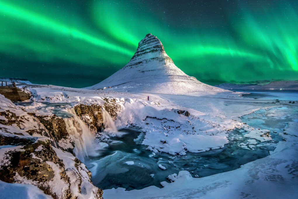
Meanwhile Iceland has had one of their coldest months in a very long time, with temps as cold as -20C in the warmer southwestern region near Reykjavik and Thingvellir (one of the main tourism areas inland from the capital).
I was there in November and it was nothing like this, now (I saw about -10C up in the northern part of the country, which is more typical). Capital area was -1 to about 6C while I was there. What a difference.
-
1 hour ago, weatherpruf said:
The only thing that could bail this winter out would be Feb 2006 type storm. other than that, I'm thinking selling the big snow blower was the right move. Don't need a big one anymore anyway; don't have to get out for work.
For the latter issue, I drive a WRX. With a 60 mile commute up the parkway, having a car like this is a dream (not to mention fun, especially in snow). Unfortunately since getting it the only real storm I had to drive in was Feb 1 2021. Years prior I would borrow my father's F150 for larger storms, and in having my current job since 2009, I have some crazy memories of driving the parkway in horrific conditions.
-
63F now at my house. Up from 27F this morning.
I think that qualifies as a torch
 .
.
-
Everybody stuck watching reruns of “Attack Of the Niña” while hoping we finally get to watch “Revenge of the Weenie.”
Definitely the better movie IMO. I especially like the battle between Anafrontal Snowwalker and Nosnowbi Juan Niñobi.
-
 4
4
-
-
1 hour ago, the_other_guy said:
The temperature variances in the city during these warm ups astound me over the last 10 years?
why can’t the city cool off at night during these warm periods? Why is the UHI stronger than it is during any other period? It makes no sense.
Central Park at 48F. Every suburb is 10-15 degrees cooler at 8 am!
I woke up at 27F on the Tempest down by me. Yeah, the difference is pretty staggering. I’m just about the opposite of a UHI being near the pine barrens with my home situated at the edge of a forest, but yeah.
-
4 hours ago, Allsnow said:
Some can’t deal, the minute you accept that it’s out of your control and it’s going to do what it wants to do it gets better.
We do summer very well around here now so their is always that
I totally admit it’s extremely upsetting to me. It’s very hard to accept what we’re staring down for a couple weeks
 .
.
-
50 minutes ago, North and West said:
Maybe they're reading into a volcanic (you probably know the correct word to use here) incident cooling things off after reading your research?
Haha, I would expect if anything Hunga Tonga will be having some impact on the SPV and teleconnections, but it’s beyond me to say precisely what. Need someone skilled with atmospheric physics but who also has some understanding of volcanic climate impacts (perhaps why there isn’t a ton of research in this area, there is some no doubt, but for how impactful volcanoes can be on the climate and how historically impactful they have been I would think there’d be more).
A nice and simple “net negative” influence on temperature anomalies is unlikely with the way Hunga Tonga erupted (as it was relatively sulfur poor), however there was indeed recent research suggesting its climate altering gas release was underestimated. So it’s really tough to say.
And then you get into the anomalous release of water vapor, which physics of course suggests is a greenhouse gas… And you have a confusing mess trying to sort out what impact HTHH will be expected to have this year and the following several years, and it’s why I’ve seen multiple opposite takes from several different smart people favoring different aspects of the eruption. It’s not cut and dry, and will really only likely be “known” in retrospect.
FWIW I lean toward a “chaos” element with the teleconnections, which may have already been manifesting this December. I have no way to prove that and could be entirely wrong, but I believe large eruptions can cause some alterations to global patterns via teleconnections and the SPV. We saw something like this with Pinatubo, and going back into the historical period there was all sorts of bizarre and intense weather following Tambora and Krakatau. Highly recommend people read about those events and their climatological aftermaths, it’s very fascinating.
Lord Byron and Mary Shelley actually give quite interesting accounts of the insane, stormy, and cold weather in Europe following Tambora (which was something like 10-20x larger than Hunga Tonga depending on which volume estimate you prefer).
-
What caused the slight backing off of temps, changes to the Pac jet?
-
50 minutes ago, lee59 said:
Models seem to be backing off somewhat with the warm up, after Thursday of this week.
That and waking up to a fantasy coastal that gives me a significant dump before hitting NE; not bad all things considered!
Let’s see if the GFS can hold that storm in any fashion through today, but realistically I’m sure it’ll swing to Bermuda before Chicago before disappearing.
Still, a better position than yesterday!
-
10 minutes ago, lee59 said:
I have mixed emotions about the bitter cold. I know it is winter and cold with snow is what it's all about. However, that cold where you don't even want to go out is not really for me, especially as I get older. It used to bother me when it didn't snow, now not so much.
Of course, I don’t necessarily require bitter cold to not feel that depression, but I absolutely do require a seasonal winter vibe.
I did genuinely enjoy the past several days though; there’s something about real cold air that I find uplifting and refreshing. I can’t really explain it, though admittedly I probably have some wires crossed somewhere
 .
.
I’m the sort that would be happy as a clam living and working in Antarctica.
-
24 minutes ago, winterwx21 said:
Beautiful day. 48 degrees here as our warm pattern has started. Frustrating that it appears that it will be a long time before we see our first snowstorm of the season, but I will enjoy the warm weather. I think we'll see 60 degrees the middle of next week.
I’m glad someone at least will appreciate this weather. Seriously, no snark intended at all. I genuinely already feel whatever the reverse of seasonal-affective disorder coming on. Instead of being depressed in the cold, snowy winter months, I get depressed when it’s warm and sunny in the winter instead
 .
.
Get out and enjoy it at least so somebody is
") .
.
-
3
-
 1
1
-
-
For my birthday in Feb, I’m trying to plan a predominantly hiking focused trip to New England / NNE. My wife and I are experienced winter hikers though we haven’t done much in the northeast US and am hoping to get out there and see some beautiful sights.
I’m interested in locations around Mass, NH, or Vermont (Maine might be just a bit too far for our purposes right now) and I’m interesting in some recommendations for places to go focused on hiking. I gather this time of year the majority of mountain locales are geared toward skiing and snowboarding, which neither of us do anymore (used to Snowboard, unfortunately have had severe back injuries that took that from me). So I’m really unsure of what places would be ideal for hiking at this time of year.
I’m totally open to any recommendations of any kind, my only ask is nice and broad; general “outdoors”
 . We do prefer day hikes to camping and would also love any cool towns to visit to stay, eat, and drink. We’re very well prepared for the cold and have suitable gear / clothing.
Greatly appreciate any suggestions!
-
1 hour ago, the_other_guy said:
pretty sure we’ve done this already in the past five years.
We’ve had a string of winters where it just shuts down for two weeks.
either way, with the shut out in December coupled with this, this is a throwaway winter in terms of snowfall…unless something unprecedented occurs
This is already a statistically unusual start to winter as Bluewave points out below. I understand what the stats say, but this wasn’t a shutout pattern the way some of the other Decembers were where nobody in the northeast really saw snow (except the mountains I’m sure). The storm tracks missed the coastal plain of here and New England, but there were storms and there was snowfall in addition to BN anomalies for much of the month. That’s quite different to a shutout 50 degree month where snow was metaphysically impossible to begin with. Many of the years with no snow in Dec that went on to precede terrible snow-less winters had a much warmer pattern.
Respectfully I’m going to disagree on calling the death knell on this winter. I have of course no way of knowing how things will end up, but let’s wait at least until we’re on the other end of this warm up and see what the pattern flip brings, along with the long range guidance at that time. If things are looking grim, sure.
-
3
-
-
46 minutes ago, lee59 said:
Many parts of the country had a pretty brutal December, we missed out. Now it looks like most of the country will have a mild first half of January which we won't miss out.
Eh, at least IMBY we had quite a few upper 30’sh 25l days this month, that’s solidly below normal early - mid Dec if not outright cold. Given how warm Dec has been for us lately and how the month looks to be finishing up (give or take 37 at Central Park as per Bluewave back a page), overall that’s really not bad. We just missed the snow, but the month wasn’t a torch or anything. Impressively the torch to start the month was soundly erased.
-
1 hour ago, LongBeachSurfFreak said:
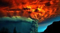
I really I hope I see a VEI 7 In my lifetime. That would bring a 1800s style winter. We are due
Don’t start me up, I don’t stop once I get derailed into my biggest earthly passion
 .
.
Yeah, the odds really aren’t that bad. You’ll typically see 2-4 VEI7 or very near 7 level events per millennium, and that number increases a bit more as you go a bit lower into the still incredibly large mid to upper end 6 range. And small to medium 6’s occur nearly every century, with the 20th having three VEI6’s with several more borderline 6’s. You really only need a borderline 6 like Pinatubo to impact the climate, assuming the volcano erupts a gaseous magma as Pinatubo did. And if you have a particularly stinky mid level 5 like El Chichon in the 80’s, you can even see a small negative anomaly from that. Borderline 5’s like St Helens are pretty much universally too small, though they can still be additive if coinciding with a larger event. It’s a little known fact that Pinatubo caused such a significant volcanic winter in part because Cerro Hudson erupted quite large the same year.
Large events really aren’t all that rare, at least insofar as we can tell from the last thousand years which has much better resolution than prior.
We also saw quite a number of large explosive events in the Aluetians and other poleward volcanoes in the early Holocene from the loss of ice and resulting containment pressure drop. I do believe we’ll see something similar as warming continues, though to a lesser extent than coming out of the LGM, at least initially.
Hunga Tonga was spectacular though, erupted at or above borderline VEI6 level within an hour or two. Most large explosive events take days. That is monumental.
Don’t forget, any (ahem) “volcanic winter” nowadays will just roll back several decades of warming for a couple years. Even if another Tambora went off tomorrow, the effects wouldn’t be as severe with respect to climate anomalies. It was already much colder then, so Tambora’s gargantuan forcing coupled with a much colder climate base state (not to mention the assist of another large event several years prior).
-
1
-
-
4 minutes ago, donsutherland1 said:
On December 24, 2022, the maximum temperature in New York City was 15°F (-9.4°C). That was the coldest December high temperature since December 25, 1983 when the temperature topped out at 13°F (-10.6°C) and tied for the 17th coldest December high on record.
The fact that it was only “17th coldest” says quite a lot with respect to Bluewave’s post and my thoughts. This will be the coldest Xmas that many, myself included, have experienced in their lifetime.
-
2
-
-
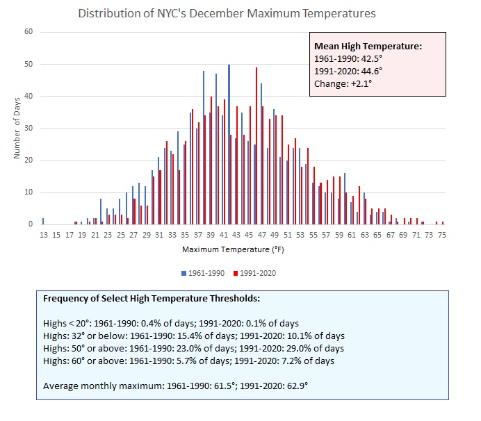
2 hours ago, bluewave said:
This December is colder than the average since 2011. The 37.3 so far in NYC is below the 12 year average of 40.6. But this is closer to average for the previous 12 years. It’s about 1° warmer than the 1951-1980 average. It’s also 3° warmer than the 1871-1900 average.
Monthly Mean Avg Temperature for NY CITY CENTRAL PARK, NY
Click column heading to sort ascending, click again to sort descending.YearDecSeasonMean 40.6 40.6 2022 37.3 37.3 2021 43.8 43.8 2020 39.2 39.2 2019 38.3 38.3 2018 40.1 40.1 2017 35.0 35.0 2016 38.3 38.3 2015 50.8 50.8 2014 40.5 40.5 2013 38.5 38.5 2012 41.5 41.5 2011 43.3 43.3
Monthly Mean Avg Temperature for NY CITY CENTRAL PARK, NY
Click column heading to sort ascending, click again to sort descending.YearDecSeasonMean 37.5 37.5 2010 32.8 32.8 2009 35.9 35.9 2008 38.1 38.1 2007 37.0 37.0 2006 43.6 43.6 2005 35.3 35.3 2004 38.4 38.4 2003 37.6 37.6 2002 36.0 36.0 2001 44.1 44.1 2000 31.1 31.1 1999 39.9 39.9 Monthly Mean Avg Temperature for NY CITY CENTRAL PARK, NY
Click column heading to sort ascending, click again to sort descending.YearDecSeasonMean 36.2 36.2 1980 32.4 32.4 1979 41.1 41.1 1978 38.9 38.9 1977 35.6 35.6 1976 29.9 29.9 1975 35.8 35.8 1974 39.3 39.3 1973 39.0 39.0 1972 38.5 38.5 1971 40.8 40.8 1970 34.4 34.4 1969 33.4 33.4 1968 34.2 34.2 1967 38.2 38.2 1966 35.7 35.7 1965 40.5 40.5 1964 36.4 36.4 1963 31.2 31.2 1962 31.5 31.5 1961 35.5 35.5 1960 30.9 30.9 1959 38.4 38.4 1958 29.3 29.3 1957 40.2 40.2 1956 40.9 40.9 1955 29.7 29.7 1954 35.9 35.9 1953 41.3 41.3 1952 38.4 38.4 1951 39.1 39.1
Monthly Mean Avg Temperature for NY CITY CENTRAL PARK, NY
Click column heading to sort ascending, click again to sort descending.YearDecSeasonMean 34.1 34.1 1900 36.2 36.2 1899 38.1 38.1 1898 35.0 35.0 1897 38.6 38.6 1896 34.4 34.4 1895 38.4 38.4 1894 36.7 36.7 1893 34.9 34.9 1892 32.2 32.2 1891 42.5 42.5 1890 30.0 30.0 1889 39.7 39.7 1888 34.7 34.7 1887 33.4 33.4 1886 29.7 29.7 1885 35.3 35.3 1884 33.6 33.6 1883 31.6 31.6 1882 30.6 30.6 1881 39.0 39.0 1880 26.4 26.4 1879 36.8 36.8 1878 33.2 33.2 1877 37.4 37.4 1876 25.0 25.0 1875 33.4 33.4 1874 34.4 34.4 1873 36.7 36.7 1872 26.7 26.7 1871 29.0 29.0 Wow, that is so incredible… Seeing temperature data for Dec alone listed this way, makes it overtly clear how we lost Dec as a winter month. Look at the consistency of cold to very cold Decembers going way back! 40 was even an anomaly, now it’s what we should expect at minimum (it feels like, anyway).
Again, how is this not monumentally depressing to people? Rhetorical, I know the reasons (including people don’t enjoy the cold), still this is so “in your face” major. One month, yes, but such an absolutely remarkable change from what was geologically a nanosecond ago.
I need a Xanax after reading this.
-
2
-
-
And truly, I want to see a DJF with a -4/5 departure to mirror the occasions we torch to the opposite. Just to prove we can do it.
C’mon Mother Nature, I dare ya!
-
1
-
1
-
January 2023
in New York City Metro
Posted
Yeah, I mean I agree with you. I said on here a while back I don’t understand how people don’t find this more disturbing, but even here many people “love the warmth.” Totally respect that, but I would think concern over the state of the climate would win out in DJFM from a bunch of weather enthusiasts. It’s just almost a sure thing, especially in Dec as per all of Bluewave’s data, that we have a big fat warm up every year.
I’m not saying it will, but if this winter repeats similar positive departures from 19-20 that should have everyone at attention.