WxSynopsisDavid
-
Posts
563 -
Joined
-
Last visited
Content Type
Profiles
Blogs
Forums
American Weather
Media Demo
Store
Gallery
Everything posted by WxSynopsisDavid
-

Major Hurricane Melissa - 892mb - 185mph Jamaica landfall
WxSynopsisDavid replied to GaWx's topic in Tropical Headquarters
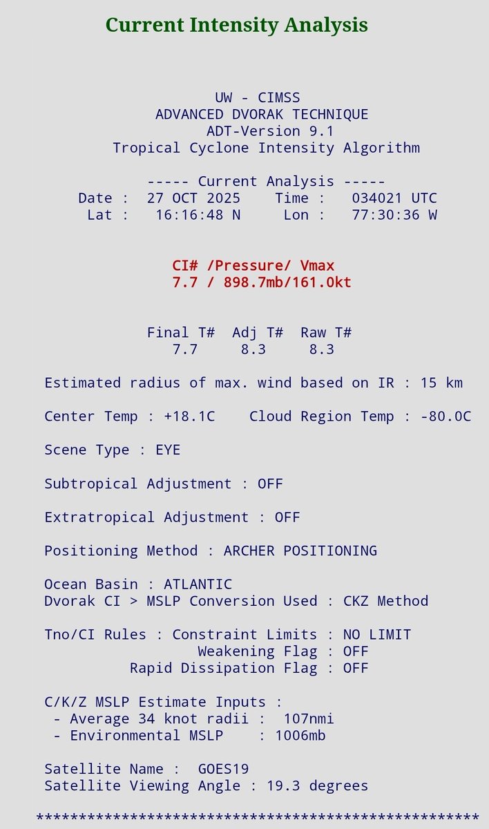
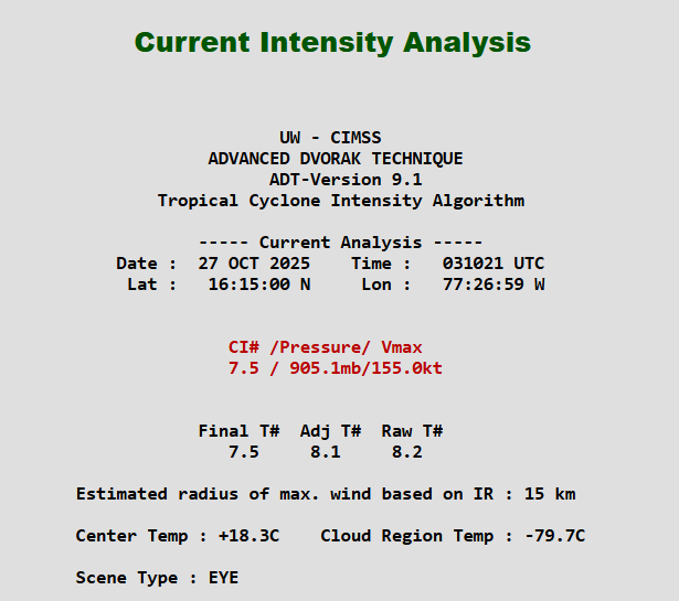
Understand Dvorak is an estimate and it should be used as a tool. Typically when you see those sub 900 estimates on Dvorak, add 20 to get an accurate estimate. In the case of Melissa, Dvorak was pretty much spot-on if you added 20 to the pressure estimates. -
Major Hurricane Melissa - 892mb - 185mph Jamaica landfall
WxSynopsisDavid replied to GaWx's topic in Tropical Headquarters
-
Major Hurricane Melissa - 892mb - 185mph Jamaica landfall
WxSynopsisDavid replied to GaWx's topic in Tropical Headquarters
Definitely Category 5, just need NE quad sampled to confirm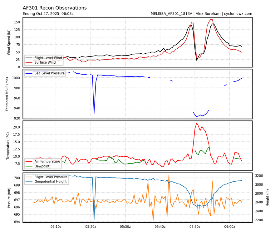
-
Major Hurricane Melissa - 892mb - 185mph Jamaica landfall
WxSynopsisDavid replied to GaWx's topic in Tropical Headquarters
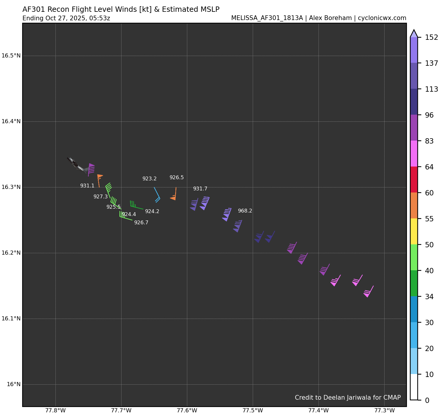
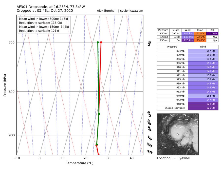
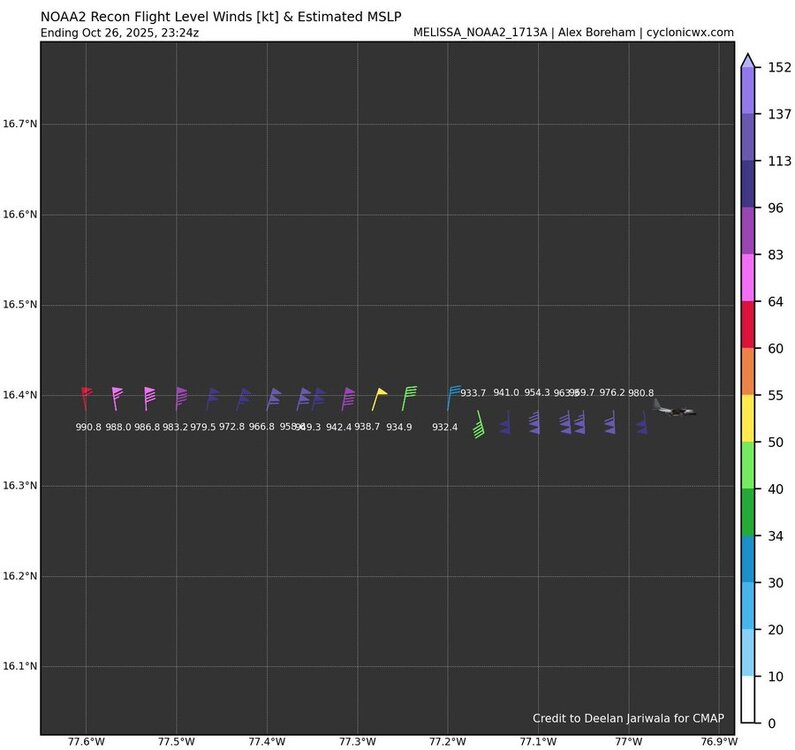
Recon just started measuring, give them time. This reading is, again, from the southeast quadrant of the eyewall. The highest winds in a hurricane reside in the northeast quad where the lowest pressure also resides. We are minutes away from finding out what the NE quad measures. -
Major Hurricane Melissa - 892mb - 185mph Jamaica landfall
WxSynopsisDavid replied to GaWx's topic in Tropical Headquarters
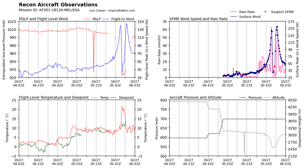
Um……923mb in the S/SE quad of the eye? Oh boy, this just escalated quickly. Wonder what the NE quad measures.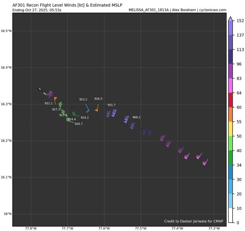
-
Major Hurricane Melissa - 892mb - 185mph Jamaica landfall
WxSynopsisDavid replied to GaWx's topic in Tropical Headquarters
Dvorak Technique says “hold my beer” -
Major Hurricane Melissa - 892mb - 185mph Jamaica landfall
WxSynopsisDavid replied to GaWx's topic in Tropical Headquarters
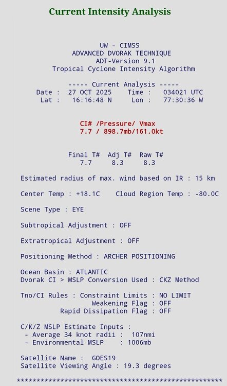
Thinking they find pressure in the 910mb-920mb range. Winds in the 170-180mph range. Strictly based on satellite and infrared imagery, also factoring in ADT estimates. -
Major Hurricane Melissa - 892mb - 185mph Jamaica landfall
WxSynopsisDavid replied to GaWx's topic in Tropical Headquarters
-
Major Hurricane Melissa - 892mb - 185mph Jamaica landfall
WxSynopsisDavid replied to GaWx's topic in Tropical Headquarters
I’m afraid the window of ERC is over. The fact it underwent the MERC earlier today was just bad timing all around for Jamaica. At some point tonight or tomorrow, when Melissa turns north, coastal friction will induce intensification that will also cause Melissa’s eye to contract and tighten. This will prevent an ERC on landfall approach. -
Major Hurricane Melissa - 892mb - 185mph Jamaica landfall
WxSynopsisDavid replied to GaWx's topic in Tropical Headquarters
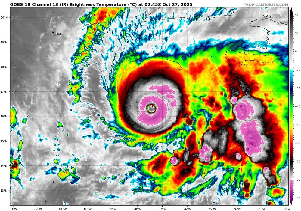
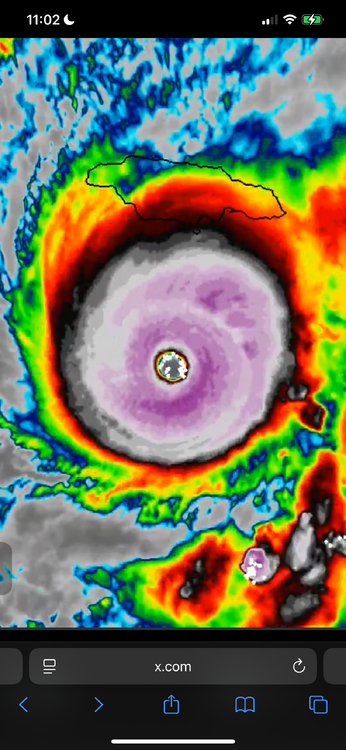
Melissa is full nuclear now. All previous signs of an ERC rapidly disappeared after recon hunters flew out. It’s like a switch went off. Absolute nuclear….cloud tops rapidly cooled to -93 degree Celsius. That is extremely unprecedented in the Atlantic Basin. Infrared imagery is jaw dropping right now. Everything I’m seeing on satellite and infrared imagery points to a high-end cane making a run at sub 910mb pressures. Lightning is impressive and very rapidly spiked in the NE/E quad of the eyewall. Really wish we had recon flights enroute.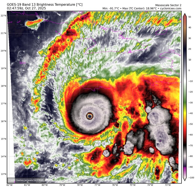
-
Major Hurricane Melissa - 892mb - 185mph Jamaica landfall
WxSynopsisDavid replied to GaWx's topic in Tropical Headquarters
Pressure holding steady and no longer tanking. Looking at TDR, perhaps an outer eyewall trying to go up. Looks like an ERC or MERC about to commence soon.
-
Major Hurricane Melissa - 892mb - 185mph Jamaica landfall
WxSynopsisDavid replied to GaWx's topic in Tropical Headquarters
Which presents an even more dire situation for those dense coastal areas. Based on a more west track, storm surge would be maximized. No matter the scenario or potential tracks left on the table, each one is catastrophic or devastating for Jamaica. Also, a more west track increases the likelihood of a peak intensity landfall being it will be over warmer waters longer. -
Major Hurricane Melissa - 892mb - 185mph Jamaica landfall
WxSynopsisDavid replied to GaWx's topic in Tropical Headquarters
-
Major Hurricane Melissa - 892mb - 185mph Jamaica landfall
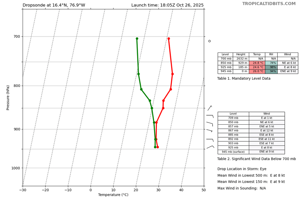
WxSynopsisDavid replied to GaWx's topic in Tropical Headquarters
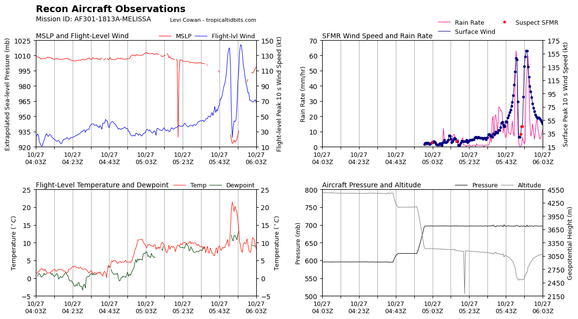
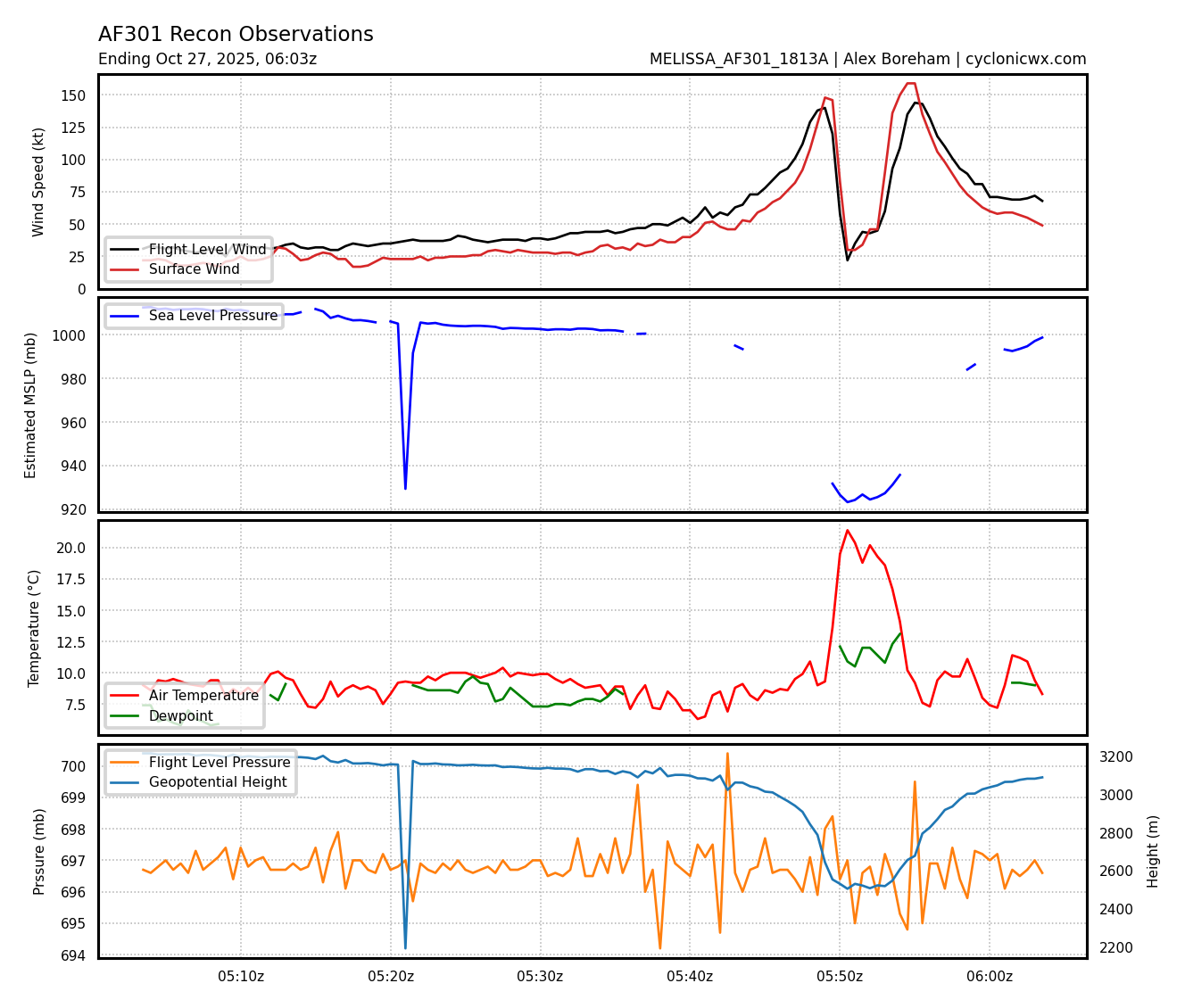
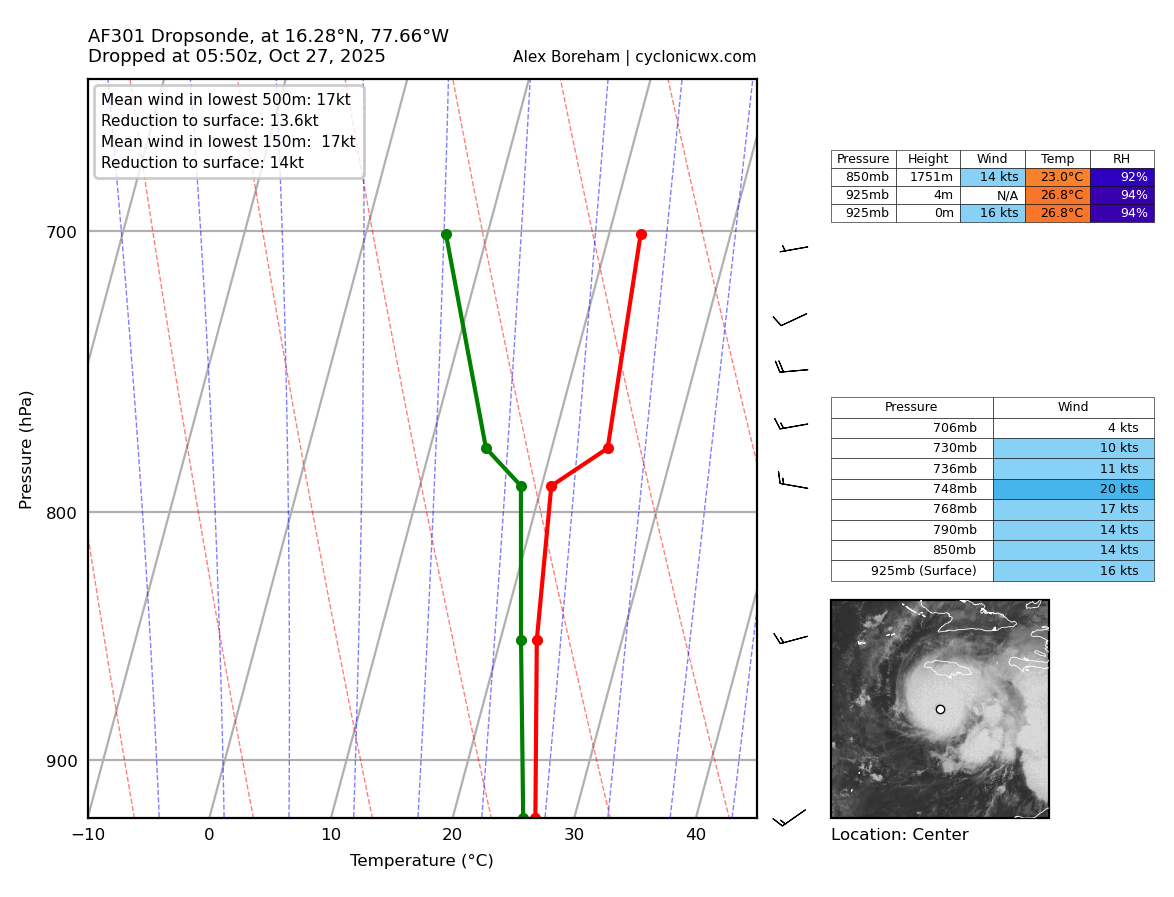
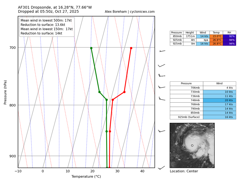
Latest dropsonde data supports Melissa is not only intensifying but is likely hours away from another potential rapid intensification process. Both images are 2 hours apart, and show an incredible structure change to Melissa’s eye. So while the internal process is not an ERC, it was very much structural and likely about to wrap up. The internal process was truly hindering mixing. First pass subsidence was not fully established. The second pass subsidence is highly noted. This is a precursor to a high-end hurricane going nuclear.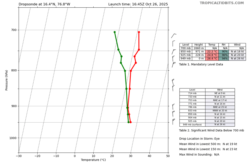
-
Major Hurricane Melissa - 892mb - 185mph Jamaica landfall
WxSynopsisDavid replied to GaWx's topic in Tropical Headquarters
With Melissa being a small, compact storm it’s possible they haven’t found the “sweet spot” in the northeast quad. Ive seen in years past where recon sometimes miss the sweet spot with these small compact systems. Other thing to consider is Melissa is undergoing some sort of internal process. Not an ERC but there are many different types of internal processes that a cyclone can undergo. -
Major Hurricane Melissa - 892mb - 185mph Jamaica landfall
WxSynopsisDavid replied to GaWx's topic in Tropical Headquarters
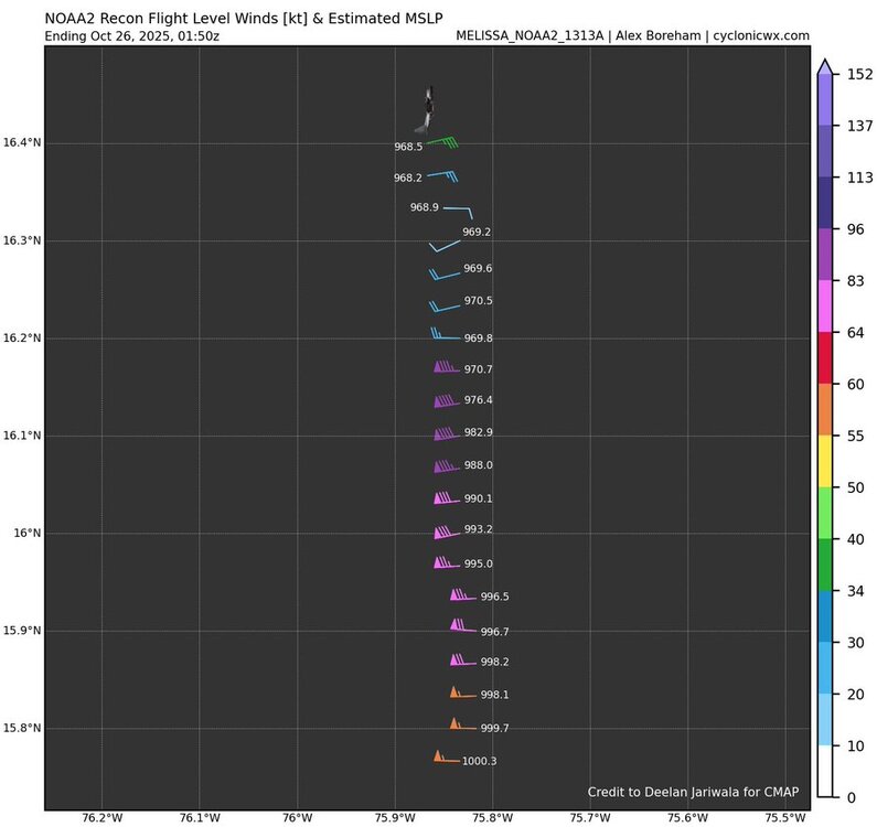
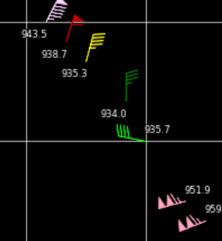
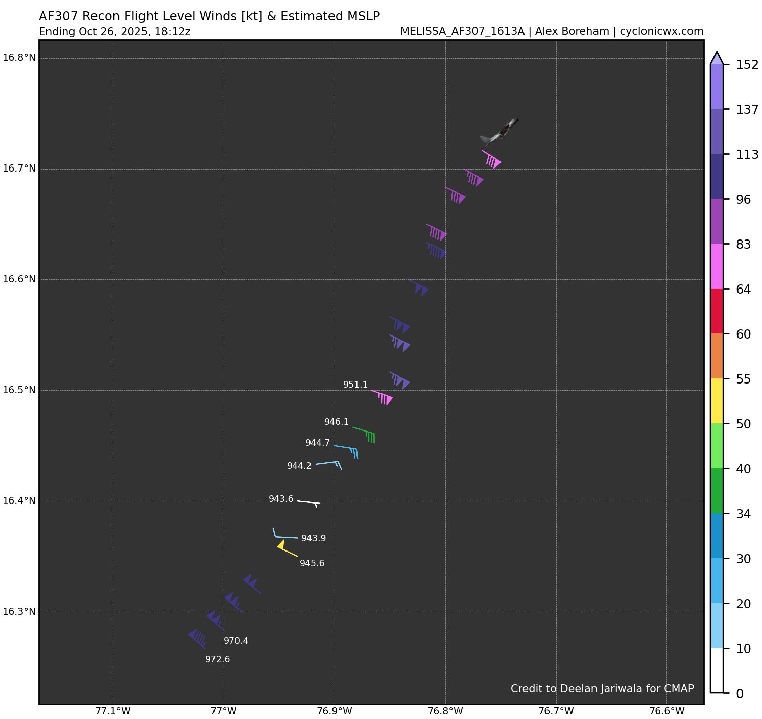
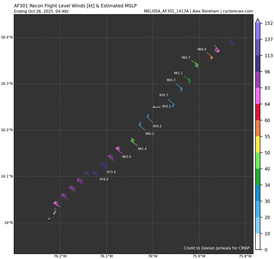
That’s a 4mb drop between recon passes -
Major Hurricane Melissa - 892mb - 185mph Jamaica landfall
WxSynopsisDavid replied to GaWx's topic in Tropical Headquarters
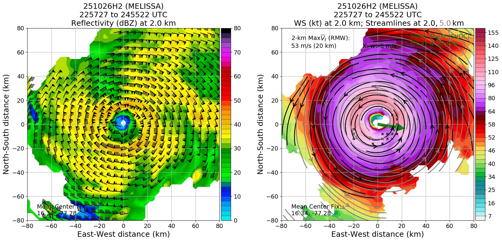
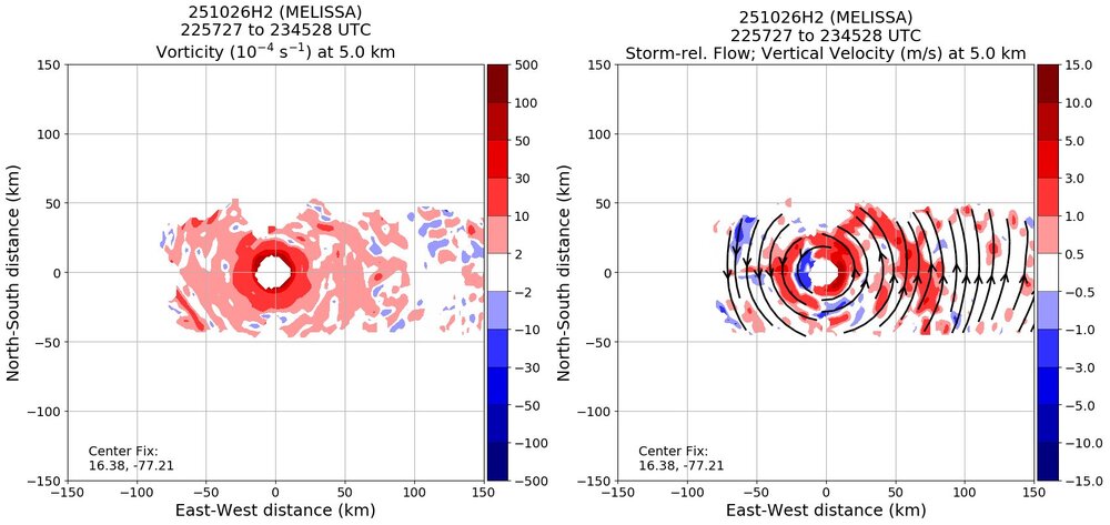
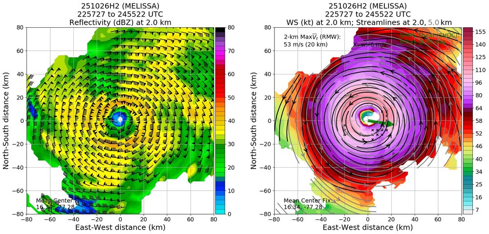
No, recon data does not find or support a double wind maxima. No signs of a concentric eyewall either. Pressure is again lower on recent pass. Pressure continues to drop but winds are not catching up yet. -
Major Hurricane Melissa - 892mb - 185mph Jamaica landfall
WxSynopsisDavid replied to GaWx's topic in Tropical Headquarters
Latest vortex message states the eyewall is square. This has only been seen in the strongest upper-echelon hurricanes. -
Major Hurricane Melissa - 892mb - 185mph Jamaica landfall
WxSynopsisDavid replied to GaWx's topic in Tropical Headquarters
I mean, one has to imagine based on what we are seeing on latest imagery, pressure will be even lower on next pass.
-
Major Hurricane Melissa - 892mb - 185mph Jamaica landfall
WxSynopsisDavid replied to GaWx's topic in Tropical Headquarters
ERC is the only limiting factor left on the table. Not a great place to be in a forecast for an intensifying hurricane. -
Major Hurricane Melissa - 892mb - 185mph Jamaica landfall
WxSynopsisDavid replied to GaWx's topic in Tropical Headquarters
Unfortunately, with atmospheric conditions progressively becoming more favorable with each passing hour, I do not see a scenario where Melissa does not efficiently achieve its MPI. Land interaction or internal structural changes are the only limiting factors until it's picked up by the trough in a few days. I also like to add, the angle of approach and slow forward speed might also add to Melissa undergoing intensification on landfall. Frictional induced intensification, with the higher terrain forcing Melissa’s core to remain compact and tighten up on final approach. Theres just no scenarios remaining that are “best case scenarios”. No matter what scenario is on the table, each one is equally catastrophic and devastating. -
Major Hurricane Melissa - 892mb - 185mph Jamaica landfall
WxSynopsisDavid replied to GaWx's topic in Tropical Headquarters
Sadly, there’s a lot of analogs Melissa compare to and they all are not good analogs. I spent 2 hours plugging in all the data to ChatGPT and interestingly enough, it says Dean (2007) is a very similar analog. Completely forgot about this storm. Though it did say Melissa’s intensification and structural evolution mirror Deans. But then I get to thinking and yes, Maria came to mind. -
Major Hurricane Melissa - 892mb - 185mph Jamaica landfall
WxSynopsisDavid replied to GaWx's topic in Tropical Headquarters