-
Posts
154 -
Joined
-
Last visited
Content Type
Profiles
Blogs
Forums
American Weather
Media Demo
Store
Gallery
Everything posted by Saguaro
-
Monsoon pattern has started up. There was a dust storm warning a few days ago as well. KFFZ 270215Z 05010KT 1 1/4SM +RA BKN028 BKN070 OVC090 26/19 A3004 RMK AO2 RAB01 P0020 T02610189
-
IZG at 93. Solid summer day.
-
Abundant sunshine out there this morning, with temperatures in the lower 80s. IZG is already upper 80s. Dewpoints were mid 60s but are mixing out already. Forecast is for 90 but we'll see if that actually happens. I'm sure IZG won't have any issue reaching it, but it runs a bit cooler over here with the lakes around. Forecast calls for 80s returning by Wednesday and lasting through the end of the week. It feels like this is a persistent trend no matter what the summer. Even in 1995, outside of that one day in southernmost NE, the record heat was consistently shunted to the south. The only years I can think of which might have been exceptions to this would be 1988, 1999, and 2002. It has moved into western Maine as well. It's weird because it stops right at the 302 crossing of the saco river swamp area in Fryeburg. East of there the trees are normal.
-
Today's the first solid summer day I've felt since arriving here back on the 6th. It feels a tad humid too but the dewpoints are only upper 50s. I guess I'm still used to the 20s dewpoints in AZ. Temperature is currently in the mid 80s. Headed back to AZ mid week, and with the shift to the monsoon pattern, the dewpoints there will be 50s to mid 60s for the foreseeable future. Lots of bare trees in North Conway and Fryeburg too. I don't know if it's those same bugs that were doing it in SNE the last few years.
-
Another battle of clouds and sun today, low level marine crud with this onshore flow. Struggling to reach 70. Satellite trend looks like it may clear out better with time.
-
Yea I should have been more clear with that. I had in mind the classic heat events from summers past, which last 3 or more days. Dewpoints at least mid 60s, daytime highs 90+. I don't really see one or two days of muted, upper 80s to 90 as qualifying, at least not by this time of the season. Perhaps this relentless trend will relax some in the coming weeks, but it's been my observation that more often than not, Junes which turn out like this one lead on to lackluster summers. That's just for this part of NE though. SNE has better chances of getting something unless this turns out like 96, 2000, 2009, or the second half of 2013. Many a time the warm front stalls, keeping ME and the coastal plain of NH/NE MA shut out while SNE and VT can pull off several days of summer.
-
It reminded me of my years living in socal. We'd get stuck in those May Gray/June Gloom patterns where the onshow flore/marine layer wouldn't budge for several days on end. When it was badly entrenched enough there'd sometimes be what LOX called "reverse clearing," where the immediate coast broke out in sun while inland was boned and never cleared out. That warm front ground to a screeching halt in central NY. Usually they make it to at least the merrimack valley this time of year.
-
Sunshine finally won the battle. The edge of gloom has receded west into the SE third of New Hampshire. Temps have risen to the lower 70s.
-
Mixed sun and clouds in western ME, it's gotten up to mid 60s. We're right on the edge between that giant mess that extends back to central NY, and the clear skies in the rest of ME. Quite breezy too.
-
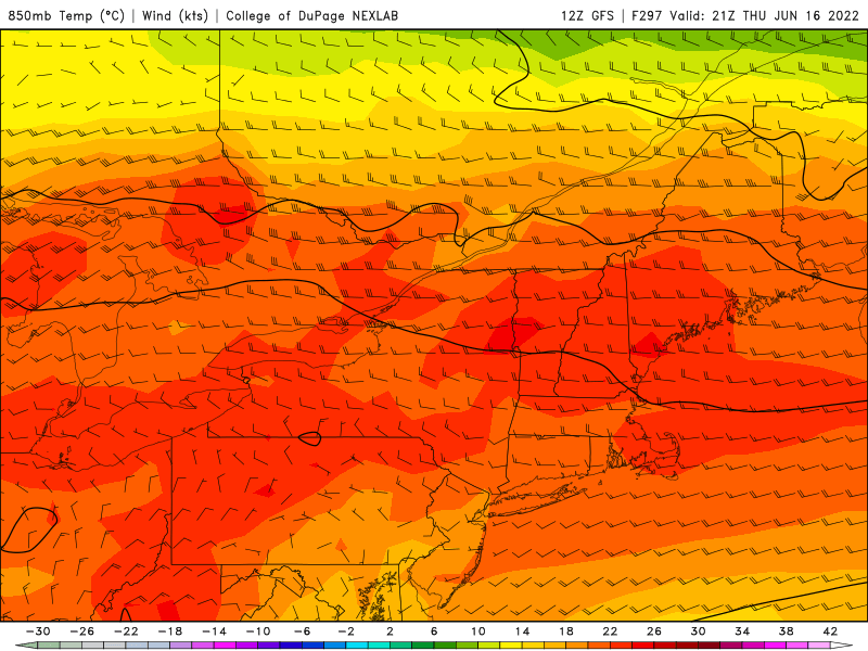
I just don't think this will be a summer for any kind of heat in NE. I've seen this type of regime settle in for many of the summers of the 2010s and it's all too familiar. There's a burst of heat in May and then a pattern change where the door slams shut for the remainder of the warm season. More often than not, May ends up having the highest daily temperatures of the season. We've even just had the requisite horror show we went through over the weekend which is a staple of these types of summer patterns. Sunday we were in the 40s and lower 50s all day with thick overcast and afternoon rain. Even back in January and February I don't recall any day that chilly and miserable in Phoenix. Another thing of note is how these 23-25c 850 temps moving well into Ontario and Quebec at the moment are absolutely obliterated once they try moving east of the Tug hill longitude. There's even some kind of cyclonic circulation backing into NE from the atlantic while that's happening.
-
If you're in Bath that is probably the line that came through here in the IZG area a couple hours ago. I believe that is associated with the front itself since it felt like the dewpoints dropped once the sun came back out. It was just getting started when it came through here so nothing other than a few rumbles, some wind and brief bouts of heavy rain before it was done. Yea I believe it came through here too around noon with some weak storms. Crashed temp from near 80 back to mid 60s. It's recovered to mid 70s.
-
On the satellite it looks like some kind of pre-frontal precip starting up. Not sure where the warm front is at this point, it was already a mess before moving into NNE. I think we're at the "WPC throws up their hands and gives up placing it" phase of it at this point. Still sunny, making a run towards 80 here now and breezy.
-
Sun has broken out in western ME. Currently low to mid 70s. GYX surprisingly mentioned a possible weak tornado this afternoon in the AFD.
-
Finally feels like more of a summer airmass out there this morning in the Bridgton ME area. However, as usual the coastal plain is stuck in marine crud. Hopefully we can see some sun before the inevitable cold front barrels through later today. Weekend looks like we're going back to April.
-
There was something getting started in the Bridgton area yesterday afternoon. I was outside and heard a lot of thunder but only saw fair weather cumulus everywhere. Not sure if that was what eventually developed into something that went through your area. Yea I think at this point we can stick a fork in the chances for NE. It's just not looking promising. GFS has reverted back to that buzzsaw vortex look. That once impressive heat signal around the 17th looks to verify as a transient overnight warm sector at best. Not seeing much in the long range after that.
-
I've read your analysis for years, and having gone through many a lackluster warm season in ME before finally moving west, gained a lot of insight into the labradorian curse that plagues that part of NE. This year's June Sonoran heat event so far has come in a couple degrees below forecast highs, at least back in my part of AZ. 114 and 115 were initially expected, verifying at 112. Today's the last day of it in the Phoenix area for a while, though there might be another run later in the week. Past that point, there's some signs of the monsoon pattern starting up. I noticed that the GFS has started coming around as you hinted it might, there does appear to be some chances for summer warmth coming in around the 17th, albeit a one day deal instead of anything substantial. Past that point it offers some hope for some more regular chances for it, vs the shutout trough it depicted before.
-
Yea I'm not seeing it lately. Last week it had quite a few runs showing a solid pattern change to summer and reloading warmth, along with some impressively warm 850 temps over NE. Now it's gone back to the hallmark signature to summers of the 2010s: A struggle to get 850 temps higher than 10c, very transitory departures greater than that, and a seemingly fixed maritime trough that buzzsaws any heat domes attempting to make inroads past the great lakes. Maybe it will flip again, but during my years in NE I saw more than one summer where June unfolded this way and we ended up with May having the highest temperatures of the season. Interesting that there's no conventional explanation for this behavior, it happens a lot in NE as you've mentioned in past writeups. It really seems like there's an infinite capacity for new, unforeseen wrinkles to show up like this. I think last year around this time in June there was a similar SW heat event. I'm back in Maine now for a few weeks so I'll miss this one, but forecast shows up to 114. I think last year's was forecasted a bit higher in the Phoenix area but ended up verifying lower. Friday: Sunny and hot, with a high near 112. Friday Night: Mostly clear, with a low around 84. Saturday: Sunny and hot, with a high near 114. Saturday Night: Mostly clear, with a low around 84. Sunday: Sunny and hot, with a high near 112. Saturday looks to be the peak of it.
-
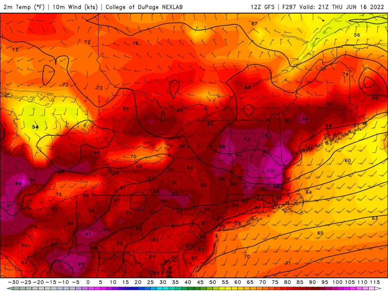
0Z GFS showed impressive 850 temps around mid month, and 12Z run still has them. I'm surprised the surface temps aren't higher.
-
Visible satellite shows much of ME once again socked in with the low level marine gloom today. It's finally eroding, though in IZG area that perfectly coincided with some popup storms, so that delayed things further. As of around 15 minutes ago it seems they finally broke out of it. It's amazing how difficult it becomes to get rid of this crud once a BD moves through, and how long it can take. Today is day 6.
-
-
On the way here next week. I wonder how verification will go as we get closer. Monday: Sunny, with a high near 104. Monday Night: Clear, with a low around 78. Tuesday: Sunny, with a high near 106. Tuesday Night: Mostly clear, with a low around 80. Wednesday: Sunny, with a high near 108. Wednesday Night: Mostly clear, with a low around 80. Thursday: Sunny, with a high near 109. Thursday Night: Mostly clear, with a low around 82. Friday: Sunny and hot, with a high near 111.
-
Even worse in IZG area. A mid level band of clouds stole monday away as well. This week has been a classic example of just how these things can rob several days of potential summer along with daylight during the precious few weeks of the year surrounding the solstice. The tendency for WPC and NWS to simply pretend these boundaries vanished was one of my pet peeves when I lived there. The satellite, wind obs, and temps all still show a definite contrast. That's about as classic a depiction one can get of the coastal plain being porked by these. I don't see it going away today either, especially in NNE where there's overrunning convection/higher clouds. I went through enough of these watching visibile satellite trends to know when the rest of the day was shot. As for the longer range, GFS says there might be a chance of summer making an attempt of showing up in about two weeks. Yesterday's 18Z run was miserable but the 0Z completely flipped around to show some solid heat working in. Today's 12Z walked that back significantly with another backdoor showing up on the 14th, but still offered more hope than yesterday's 18Z run.
-
From my years of observations, more often than not, there always seemed to be a new unaccounted for wrinkle/fly in the ointment of things that would go wrong for realizing heat or convection in ME/eastern NE. I don't recall ever seeing "excessive -AO" being one of them. I still remember the summer of 2005 a day in July or August when there was going to be record breaking heat in Maine, much talk of triple digits, only to have an unforeseen, stout high cloud deck show up to put the kabosh on it. Probably the only time I experienced temps holding well into the 90s there despite an overcast sky. Lately I've noticed a distinct trend away from the unusual summer-reload type patterns the GFS had in its long range for NE periodically the past couple weeks. It's now reverted to its typical behavior seen in May/Junes past. Not what one likes to see on June 1 for sure, at least if you enjoy summer. Quite the contrast to initial depictions last week of 4 day heat, basically a 40-45 degree swing. Was 98 out here today safely away from the backdoor, and I'm happy I was here vs the IZG area, hours of slate gray 50s with intermittent sprinkles. One of those blackfly and mosquito days.
-
IZG never had a chance today. Much wasted potential with a high launchpad before the BD blasted through around 6am. Looking through the obs history, it had actually gotten up to 75 at that point. Around 9am, the gloom began materializing and by 10, ceilings had lowered to 2300 with solid overcast. Glad to be here vs there today with our SKC and 91/34. I expected to see much more stratus on satellite but at the moment it appears to be a thin band stretching from QC/ON border southeast to the coast between PSM and PWM. I'm not sure what the cause of that band is as it seems to be more upper level stuff given its movement. It looks like there is lower level moisture condensing in that vicinity as well. I imagine once the sun goes down all bets are off and there will be an explosion of low stratus. From my years of seeing these, they do seem to more often than not have momentum issues during the day. Many a time they'd barrel from CAR down to BGR and then stall somewhere between there and PWM midday. Overnight they'd resume, and make it to the NH/MA border by sunrise.
-
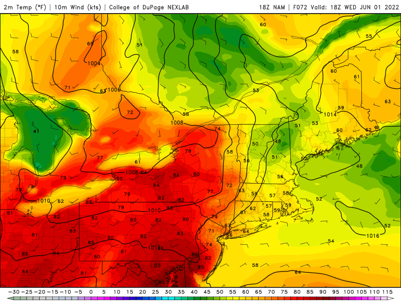
From all my years living in ME, we never got any kind of interesting convection from these. It will probably just be a wind shift to low ceiling, clammy miserymist. The NWS forecast in western ME is about as bad as it gets for Tuesday onwards if you're ready for summer. I did notice the 12Z GFS shows an interesting bermuda high pattern for late next week, but obviously that's too far away to be taken seriously right now. 18Z NAM shows it getting all the way to Philly on Wednesday, with the misery epicenter over MWN.


