Mount Joy Snowman
-
Posts
4,749 -
Joined
-
Last visited
Content Type
Profiles
Blogs
Forums
American Weather
Media Demo
Store
Gallery
Everything posted by Mount Joy Snowman
-

Central PA - Fall 2021
Mount Joy Snowman replied to canderson's topic in Upstate New York/Pennsylvania
Pure brilliance sir. Post more often. -
Central PA - Fall 2021
Mount Joy Snowman replied to canderson's topic in Upstate New York/Pennsylvania
Preach. -
Central PA - Fall 2021
Mount Joy Snowman replied to canderson's topic in Upstate New York/Pennsylvania
.06" of rain, a low of 47, and some nasty northwest winds. Also, Friday night trick or treat is looking more and more like a complete and utter washout. -
Central PA - Fall 2021
Mount Joy Snowman replied to canderson's topic in Upstate New York/Pennsylvania
Don't call it a comeback. Wow I'm still locked in thick clouds just a few miles to your east, as you duly noted. -
Central PA - Fall 2021
Mount Joy Snowman replied to canderson's topic in Upstate New York/Pennsylvania
A nice little drenching last night -- 1.32" here in the Farmdale area of West Hempfield Township of Lancaster County within the Commonwealth of Pennsylvania. -
Central PA - Fall 2021
Mount Joy Snowman replied to canderson's topic in Upstate New York/Pennsylvania
I'm sorry but Alabama losing on the road by three to Texas A&M isn't even in the same stratosphere as Penn State losing at home to arguably the worst team in the B10 and being completely steamrolled in the run game in the process. I mean, I understand they lost the anchor of their D-line in Mustipher, which was overshadowed by the Clifford injury and arguably just as important, but you can't lose one guy and all of a sudden resemble some overmatched high school team on the line of scrimmage. You just can't. Franklin continues to be an excellent CEO-style figure (i.e. recruiting, at the podium, in family living rooms, overall organization, etc.) but when it comes to being an actual gameday football coach he is hot garbage. I don't enjoy saying that but it is laid bare for everyone to see on a near weekly basis and has been that way for years. I'm not even saying we'd necessarily be better off with someone else because much of what he does well (namely recruiting good athletes) makes up for his deficiencies. But can we stop with the whole "we won the explosive play battle" nonsense and focus more on actually winning the line of scrimmage. The play and development of the Oline, even when it has vast experience, is a constant yearly issue. Next week is going to be absolutely brutal. The season likely spirals downward from here. I could go on and on but I won't. I've already said too much. Sorry fellas, just disappointed. -
Central PA - Fall 2021
Mount Joy Snowman replied to canderson's topic in Upstate New York/Pennsylvania
Weekend summary: .02" of rain and an abject disaster of a performance by Penn State. -
Central PA - Fall 2021
Mount Joy Snowman replied to canderson's topic in Upstate New York/Pennsylvania
Wow you're not fooling around! I sold my Illinois tickets. I'm not expecting to see Clifford but the good guys should still be fine in this one. One of my buddies used to routinely do the Penn State thing on Saturday and then hit the Eagles game on Sunday on his way home to South Jersey, has season tickets for both. What you're pulling makes that look like child's play though haha. Have fun! -
Central PA - Fall 2021
Mount Joy Snowman replied to canderson's topic in Upstate New York/Pennsylvania
A high of 75 yesterday, a low of 53 last night, and nary a drop of rain to be found. Nice Fall weather on tap for the weekend. -
Central PA - Fall 2021
Mount Joy Snowman replied to canderson's topic in Upstate New York/Pennsylvania
Ah yes the 'ol Thomasville microclimate; the king of cold air inversions. -
Central PA - Fall 2021
Mount Joy Snowman replied to canderson's topic in Upstate New York/Pennsylvania
69 and windy with bluebird skies here. -
Central PA - Fall 2021
Mount Joy Snowman replied to canderson's topic in Upstate New York/Pennsylvania
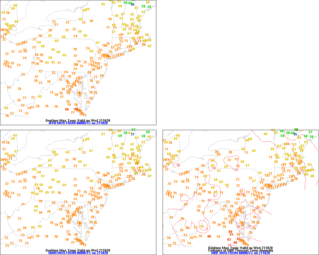
Aggressive statement sir! I like your boldness. MOS guidance doesn't like us to get above low to mid 70s. We shall see.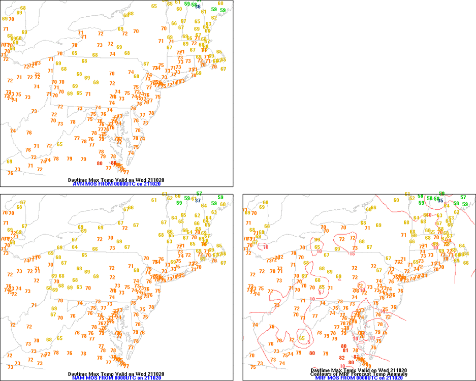
-
Central PA - Fall 2021
Mount Joy Snowman replied to canderson's topic in Upstate New York/Pennsylvania
I only dropped to 48. Judging from some of the overnight IR images, it looks like we had a narrow blanket of clouds move area this area for a good portion of the late night, would certainly explain the difference. -
Central PA - Fall 2021
Mount Joy Snowman replied to canderson's topic in Upstate New York/Pennsylvania
Yep and in turn I come in several degrees lower than you. Tucked in by the farmland and sitting at a low spot off the ridge will do that. #Inversion -
Central PA - Fall 2021
Mount Joy Snowman replied to canderson's topic in Upstate New York/Pennsylvania
38 for a low last night. Snow is in the air. -
Central PA - Fall 2021
Mount Joy Snowman replied to canderson's topic in Upstate New York/Pennsylvania
I hit 47 for a low last night. That Tennessee game was a trip. I was up late watching it with a manhattan in hand trying not to dose off. I should have just gone to bed since the baby had me up at 5:30. No rest for the weary. -
Central PA - Fall 2021
Mount Joy Snowman replied to canderson's topic in Upstate New York/Pennsylvania
I got ya this time, .32” here. -
Central PA - Fall 2021
Mount Joy Snowman replied to canderson's topic in Upstate New York/Pennsylvania
I’m not shocked. They run a remedial offense. Penn State would have trucked them had Clifford not gone down. I lost a lot of respect for Ferentz this past week too with his comments about the injuries. They got what they deserved. -
Central PA - Fall 2021
Mount Joy Snowman replied to canderson's topic in Upstate New York/Pennsylvania
I’m not Training ha but I can tell you they were just garden variety. -
Central PA - Fall 2021
Mount Joy Snowman replied to canderson's topic in Upstate New York/Pennsylvania
78 is as high as I’ve gotten today and it looks like that will be the max as clouds starting to build and some small cells starting to pop to the southwest. -
Central PA - Fall 2021
Mount Joy Snowman replied to canderson's topic in Upstate New York/Pennsylvania
Topped out at a beautiful 76 yesterday and bottomed out at a crisp 56 last night. Looking forward to the first real cold frontal passage of the season on Saturday, as we look to shave about 15 degrees off the 850s. Love this time of year. -
Central PA - Fall 2021
Mount Joy Snowman replied to canderson's topic in Upstate New York/Pennsylvania
Oh yes I am keenly aware of the midnight cutoffs and the confusion they can create. In this instance I was just rushing and didn't think it through haha but you are spot on. We are likely to get screwed by both the saturday afternoon frontal passage and the temps in the 50s tomorrow morning. So, even though there will be a solid 24 hour period where the temp doesn't drop below 64ish, it will be split up in a way that won't allow for any records, as we've all seen countless times before, but that's how the cookie crumbles sometimes. In short, I take back everything I said and there will be no records being breached. I will now crawl back into my cave. -
Central PA - Fall 2021
Mount Joy Snowman replied to canderson's topic in Upstate New York/Pennsylvania
Haven't been around much lately, busy busy, but just popping in to remind everyone not to record that dew as liquid precip. I had damn near .02" in the gauge this morning but you aint foolin this guy! Fog is nice and soupy this morning. So it appears we have an outside shot at a high temp record friday and then a much better shot at a max min record friday night. Cool beans. -
Central PA - Fall 2021
Mount Joy Snowman replied to canderson's topic in Upstate New York/Pennsylvania
You're not imagining things. It absolutely is the warmer nights that contribute more to the positive monthly departures. The monthly weather summaries for MDT almost always confirm that. -
Central PA - Fall 2021
Mount Joy Snowman replied to canderson's topic in Upstate New York/Pennsylvania
Good luck! They love the Maples and especially the weed tree Tree of Heaven.