

bobbutts
-
Posts
6,317 -
Joined
-
Last visited
Content Type
Profiles
Blogs
Forums
American Weather
Media Demo
Store
Gallery
Posts posted by bobbutts
-
-
-
Rain here. Family came over from 10 mins away and reported 1/2" of slushy accumulation where they came from.
-
Had a few minutes of pea sized hail there. Just a bit of lighting.
-

that is a few blocks from the tdwr site! Crazy detail
-
 3
3
-
 1
1
-
-
1 minute ago, Cyclone-68 said:
Ugggh..Didn’t want to hear that. They just flat out refuse to go. It’s inexplicable
Sorry to hear that. Are they too young to remember Katrina? Maybe have them read up on that.
-
2
-
-
7 minutes ago, Pityflakes said:
Yikes. I think this likely exceeds Charlie in the Port Charlotte/Punta Gorda area. May actually be the zone of highest realized surge.
It wouldn't take much to exceed Charley in surge for that area. It wasn't a factor. Milton is a lock to exceed the surge and unlikely reach the same type of wind damage in Port C/PG.
-
2 minutes ago, dbullsfan said:
Most consensus seems to think this turns east well before Tampa now. This line doesn’t seem likely at all.
.It is an extrapolation which ignores all other factors besides previous motion. Not intended to be a forecast.
-
1
-
-
extrapolating the recent radar movement would bring it just up the north side of the bay

-
 1
1
-
-
6 minutes ago, schoeppeya said:
Those supercells that are offshore are going to be a really, really bad situation.
Pretty impressive radar image there

-
1
-
-
Truck tire rolling down the gulf.
-
1
-
1
-
-
-
10
-
 1
1
-
1
-
-
Watching a potentially bad surge situation approach a large low elevation population give me Katrina vibes. Having lived in SW FL I know there plenty of stubborn and complacent people who will stay in risky areas too.
-
Quote
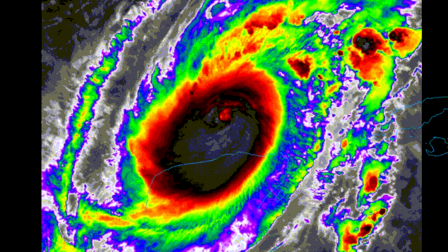
ESTIMATED MINIMUM CENTRAL PRESSURE  945 MB
EYE DIAMETER  15 NM
MAX SUSTAINED WINDS 110 KT WITH GUSTS TO 135 KT.
-
Quote
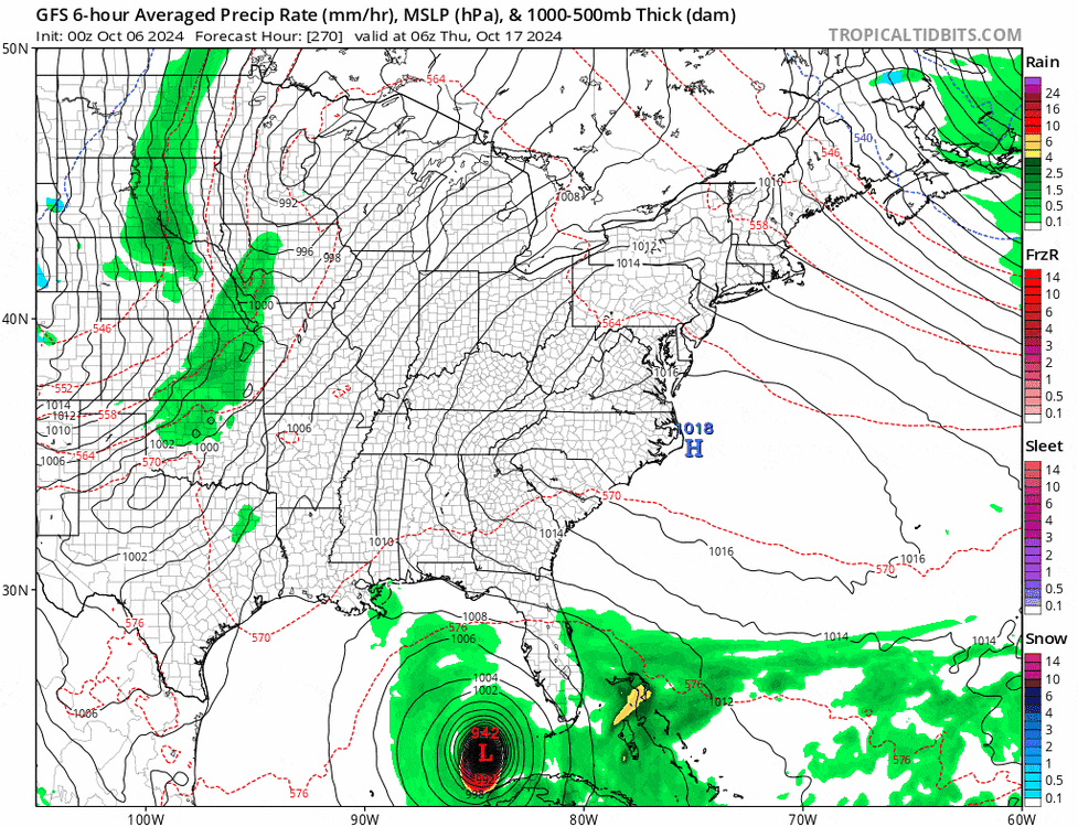
Hurricane Milton Discussion Number   6
NWS National Hurricane Center Miami FL       AL142024
400 PM CDT Sun Oct 06 2024

Milton is rapidly intensifying.  Satellite images indicate very
deep convection in the eyewall and hints of an eye starting to
appear.  The last fix from the aircraft showed that the
central pressure was down to 985 mb, about 3 mb less than 80
minutes prior, and winds supporting 70 kt at the surface.  Since
that time, satellite images continue to show further organization,
and the initial wind speed is set to 75 kt.

Milton is moving just south of due east at about 6 kt.  This
equatorward motion has been more than expected probably due to a
stronger low/ mid-level frontal low over the northeastern Gulf of
Mexico. The frontal feature is forecast to weaken while it moves
across Florida and gradually lose its influence on Milton.  This
evolution should allow the hurricane to turn eastward on Monday and
then accelerate to the northeast on Tuesday and Wednesday toward the
Florida Peninsula ahead of a trough moving offshore of Texas.  The
NHC forecast is a bit south of the previous one through 48 hours,
following the trend of the guidance at that time, and the government
of Mexico has issued a Hurricane Watch for a portion of the northern
coast of Yucatan.  Later on, the guidance is similar to, or slightly
north of the last cycle, and very little change is made to the
forecast near Florida. It should be noted that the average NHC track
error at day 3 is around 100 miles, and users should not focus on
the exact track.

The intensity forecast appears straightforward at first, with rapid
intensification likely while the small hurricane remains within
light shear and over very deep warm waters.  Intensity guidance is
about as bullish as I've seen in this part of the basin, with
almost everything showing a peak intensity of category 4 or 5 in
the southern Gulf of Mexico in a day or two.  The NHC forecast is
raised from the previous one and lies near the intensity consensus
model and still could be too low.  Later on, vertical wind shear is
forecast to markedly increase as Milton approaches Florida, and
some weakening is anticipated.  However, the regional hurricane
models are showing the system growing even if it weakens, and we are
expecting Milton to be a large hurricane at landfall, with very
dangerous impacts spread out over a big area. There is increasing
confidence that a powerful hurricane with life- threatening hazards
will be affecting portions of the Florida west coast around the
middle of this week. Residents there should closely monitor this
system and listen to local officials.


Key Messages:

1. Milton is forecast to be a major hurricane when it reaches the
west coast of the Florida Peninsula midweek. Users are reminded to
not focus on the details of the forecast as there remains
significant uncertainty in the eventual track and intensity of
Milton.

2. While it is too soon to specify the exact magnitude and location
of the greatest impacts, there is an increasing risk of life-
threatening storm surge and damaging winds for portions of the west
coast of the Florida Peninsula beginning early Wednesday and Storm
Surge and Hurricane Watches will likely be issued tonight or early
Monday.  Residents in the Florida Peninsula should follow any advice
given by local officials and monitor updates to the forecast.

3. Areas of heavy rainfall will impact portions of Florida through
Monday well ahead of Milton, with heavy rainfall more directly
related to Milton expected on Tuesday through Wednesday night. This
rainfall will bring the risk of considerable flash, urban, and areal
flooding, along with the potential for moderate to major river
flooding.

4. Tropical storm conditions are expected with hurricane conditions
possible beginning Monday across portions of the northern Yucatan
Peninsula of Mexico where a Tropical Storm Warning and Hurricane
Watch are in effect.


FORECAST POSITIONS AND MAX WINDS

INIT  06/2100Z 22.4N  93.8W   75 KT  85 MPH
 12H  07/0600Z 22.2N  92.6W   90 KT 105 MPH
 24H  07/1800Z 22.2N  90.9W  110 KT 125 MPH
 36H  08/0600Z 22.6N  89.0W  120 KT 140 MPH
 48H  08/1800Z 23.6N  86.9W  125 KT 145 MPH
 60H  09/0600Z 25.2N  85.1W  120 KT 140 MPH
 72H  09/1800Z 27.0N  83.1W  105 KT 120 MPH
 96H  10/1800Z 29.8N  77.5W   65 KT  75 MPH...POST-TROP/EXTRATROP
120H  11/1800Z 31.4N  68.8W   55 KT  65 MPH...POST-TROP/EXTRATROP
-
8 hours ago, tiger_deF said:
what an epic run, at first I didn't even notice that was the second hurricane
-
19 minutes ago, cptcatz said:
This is ridiculous to say. First of all, Milton seems to have a higher ceiling with multiple models showing possible cat 5. Even if it weakens before landfall the surge will still be there (see Katrina). Second, Helene's surge was over swamp land of the big bend while Miltons will be over developed beachfront properties. Third, even if it hits south of Tampa and spares Tampa Bay, that likely means Fort Myers gets the worst of it which is just now starting to bounce back from Ian. So basically it's a tossup between surge destruction in Tampa Bay or in Fort Myers, either of them will be bad.
To add to your point. Looking at a satellite map should help people who aren't familiar with the area. From the Tampa Bay area and south there is nearly continuous development in potential surge areas right up to the gulf and extensive bays and canals and low lying areas. To the north there's very little development right on the coast.
-
1
-
-
15 hours ago, LeesburgWx said:
I was thinking of Hurricane Charley and how that hurricane veered NE before reaching Tampa. Everyone was very worried for Tampa Bay but I have to imagine, the trajectory for Milton vs Charley is much worse, if Milton comes ashore at or just north of Tampa Bay.
Charley was running at almost a parallel angle to the FL coast and was a tiny storm with a small patch of major wind damage well inland and relatively limited storm surge. We'll have to watch the details on this but it appears to have greater potential for surge based at this point based on likely storm strength/size and approach angle/speed.
-
Not many outs on that forecast cone.
-
Not many October historical tracks like the eps there.. Closest I found was Cat 1 Unnamed Oct 24, 1859 to Oct 29, 1859. Cat 2 Unnamed Oct 08, 1888 to Oct 12, 1888 looks similar too.
Assuming my search is correct there hasn't been a hurricane that originated in the Gulf and struck within 150mi of Sarasota since that storm in 1888. Not implying any forecast with that tidbit, just find it interesting.
-
We obsess over wind but loss of life is usually the result of flooding.
-
2
-
1
-
4
-
-
Cell by Alton shows 3.5" hail icon on grlevel3. About as large as I can remember seeing. Wonder what size is reaching the ground?
QuoteAt 718 PM EDT, a severe thunderstorm was located near Alton, or 14
miles southeast of Laconia, moving east at 40 mph.HAZARD...Ping pong ball size hail and 60 mph wind gusts.
-
2
-
-
Rain and a bunch of rumbling here but winds stayed pretty light. Doubt it got over 30mph.
-
1
-
-
Looks like some large hail on the storm near Willimantic. Grlevel3 shows it as 3.25"
-
1
-
-
1 minute ago, ct_yankee said:
Unbelievably, I can't seem to transfer any chase pics from my newish Moto Stylus G5 phone to my newish high-end laptop computer. It used to be so easy with my old setup. Now I'm forced to use some Microsoft garbage utility that simply tells me it can't transfer files, for reasons unknown. And I can't load the pics directly from my phone to the forum because they take up too much memory, I need to downsize the file first, which I only know how to do from my computer. So no pics from me for the moment. Can't frickin believe I can't do a simple file transfer...
One pretty easy workaround is to install google photos and set it to back them up to the google photos site. Once setup you can go there on a computer and download them.

Turkey Day Birch Bender Snow Storm/Observation Thread 11/28/-11/29
in New England
Posted
Flipped to snow in the last 20 mins or so.