
Beach Snow
-
Posts
219 -
Joined
-
Last visited
Content Type
Profiles
Blogs
Forums
American Weather
Media Demo
Store
Gallery
Everything posted by Beach Snow
-
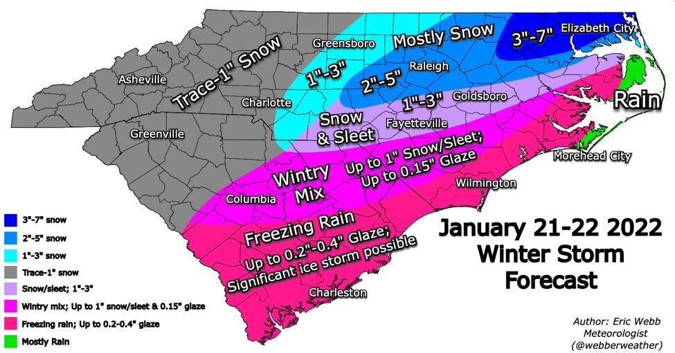
January 20-22 “bring the mojo” winter storm threat
Beach Snow replied to lilj4425's topic in Southeastern States
-
January 20-22 “bring the mojo” winter storm threat
Beach Snow replied to lilj4425's topic in Southeastern States
promising -
January 20-22 “bring the mojo” winter storm threat
Beach Snow replied to lilj4425's topic in Southeastern States
Great better than the NAM -
January 20-22 “bring the mojo” winter storm threat
Beach Snow replied to lilj4425's topic in Southeastern States
-
January 20-22 “bring the mojo” winter storm threat
Beach Snow replied to lilj4425's topic in Southeastern States
True but then do we worry about temp profiles -
January 20-22 “bring the mojo” winter storm threat
Beach Snow replied to lilj4425's topic in Southeastern States
From DT on twitter. As much as i don’t like him he has a point. Wonder if this will cause implications for the Friday event?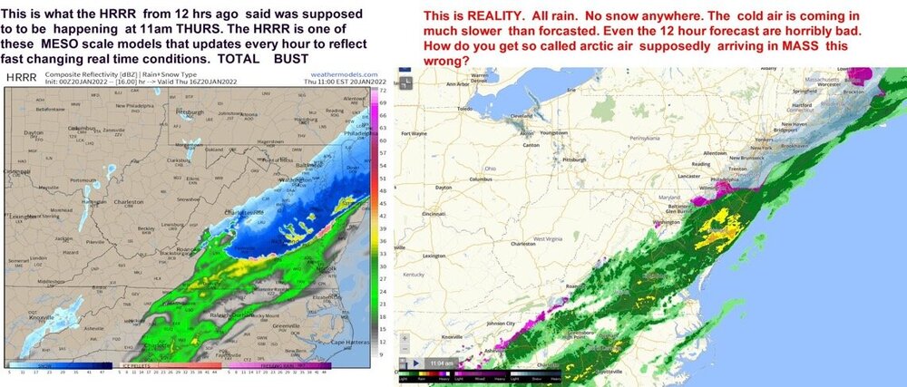
-
January 20-22 “bring the mojo” winter storm threat
Beach Snow replied to lilj4425's topic in Southeastern States
Also i don’t think the HRR performance is all that great past it’s normal run. Will be very telling as we get closer within each of its 18hr runs -
January 20-22 “bring the mojo” winter storm threat
Beach Snow replied to lilj4425's topic in Southeastern States
I feel like we would all be way more comfortable and confident if it was the opposite -
January 20-22 “bring the mojo” winter storm threat
Beach Snow replied to lilj4425's topic in Southeastern States
Can you post 500 vort comparison? I don’t see where it ticked SW. Toggling between current run and 6z looks like it’s further east by a hair compared to 6z -
January 20-22 “bring the mojo” winter storm threat
Beach Snow replied to lilj4425's topic in Southeastern States
I’m glad GFS came back west some and shows slight interaction between the NS and SS. However don’t we really want to see this on short range models like the NAM or HRR? Do the globals do a better job than the mesoscale models as far as upper air patterns? -
January 20-22 “bring the mojo” winter storm threat
Beach Snow replied to lilj4425's topic in Southeastern States
The HRR 6z is close but not close enough.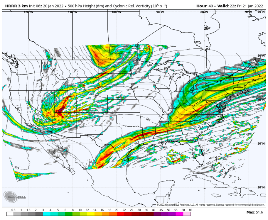
-
Big shift in Canadian

-
January 20-22 “bring the mojo” winter storm threat
Beach Snow replied to lilj4425's topic in Southeastern States
Pretty significant shift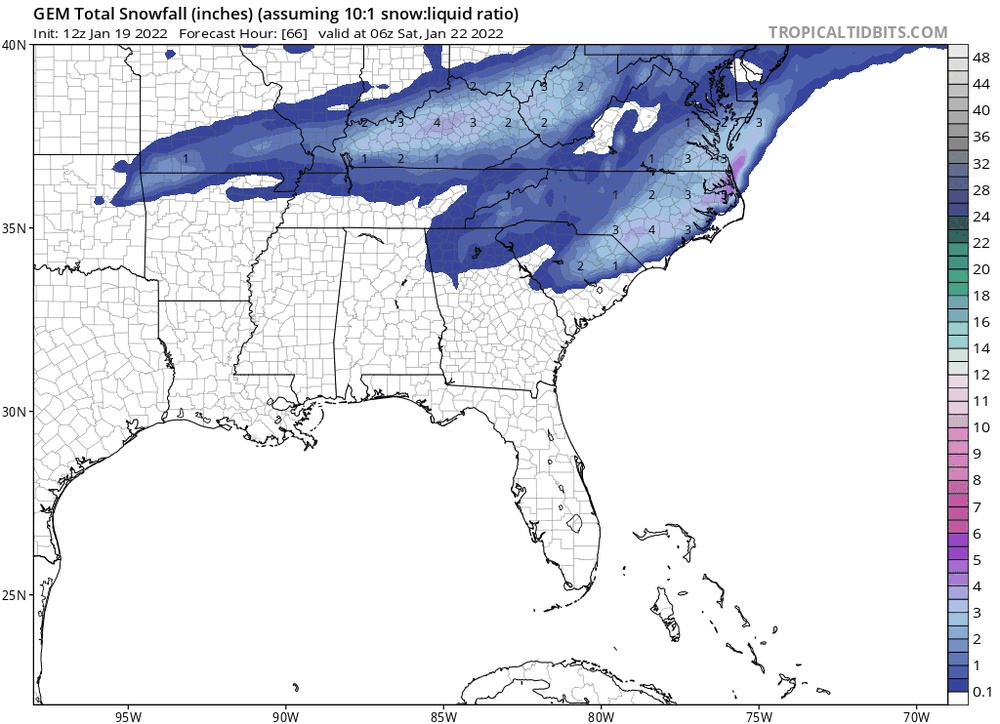
-
January 20-22 “bring the mojo” winter storm threat
Beach Snow replied to lilj4425's topic in Southeastern States
There is a time when that is valid but there is no way all the “reliable” models have it wrong -
January 20-22 “bring the mojo” winter storm threat
Beach Snow replied to lilj4425's topic in Southeastern States
-
January 20-22 “bring the mojo” winter storm threat
Beach Snow replied to lilj4425's topic in Southeastern States
I mean 6z NAM had over 14” IMBY and 18z is zip…none. So i would agree -
January 20-22 “bring the mojo” winter storm threat
Beach Snow replied to lilj4425's topic in Southeastern States
I’d give less credit to the NAM post from previous storm and the RGEM has been pretty consistent -
January 20-22 “bring the mojo” winter storm threat
Beach Snow replied to lilj4425's topic in Southeastern States
Has anyone seen the 18z RGEM!!!! -
January 20-22 “bring the mojo” winter storm threat
Beach Snow replied to lilj4425's topic in Southeastern States
I agree with this statement and that this is probably a classic NE NC SE Va with some expansive precip shields N and W like typical setups. Seen this snow setup pan out with a big event every 4-5 years or so. If Mets just solely relied on models what is the point then? AKQ issued watch for 6-8 in SE Va NE NC with the afternoon package -
January 20-22 “bring the mojo” winter storm threat
Beach Snow replied to lilj4425's topic in Southeastern States
Man RGEM not a good trend…scared to see others at 12z -
January 20-22 “bring the mojo” winter storm threat
Beach Snow replied to lilj4425's topic in Southeastern States
I think we need to see what RGEM will show. The RGEM is superior to the NAM -
January 20-22 “bring the mojo” winter storm threat
Beach Snow replied to lilj4425's topic in Southeastern States
cMC has been a rock over the last 3 days of runs -
January 20-22 “bring the mojo” winter storm threat
Beach Snow replied to lilj4425's topic in Southeastern States
I think the NAM is too amped. Not that it matters but it really didn’t handle the past storm well in its 60-84 frames -
January 20-22 “bring the mojo” winter storm threat
Beach Snow replied to lilj4425's topic in Southeastern States
Really good model consensus tonight. Seems like each model adjusted to almost the same qpf range and snowfall axis. Not to mention most appear to have the same LP placement off NC. -
January 20-22 “bring the mojo” winter storm threat
Beach Snow replied to lilj4425's topic in Southeastern States
GFS looks better throwing precip all the way back to western NC


