

WinterWxLuvr
-
Posts
29,279 -
Joined
-
Last visited
Content Type
Profiles
Blogs
Forums
American Weather
Media Demo
Store
Gallery
Posts posted by WinterWxLuvr
-
-
38 minutes ago, CAPE said:
18z GEFS doesn't look bad y'all.

Comparison?
-
3 minutes ago, Deck Pic said:
our big storm is next weekend. This is a table setter
Not according to the gfs
-
 3
3
-
-
1 minute ago, yoda said:
TPV looks a bit more stretched out and westward at h5... and energy on back side is more NW on the 18z RGEM at 84 compared to the 18z NAM at 84
The RGEM probably would have been good
-
 1
1
-
-
10 minutes ago, WinterWxLuvr said:
My money says the ICON is gonna be closer to its 6z run than 12z. Seems to be heading that way. See if I can go 0 for 2 today
Yep, 0-2
-
 3
3
-
-
My money says the ICON is gonna be closer to its 6z run than 12z. Seems to be heading that way. See if I can go 0 for 2 today
-
1
-
-
2 minutes ago, Warm Nose said:
Personally waiting for the HVNOFING-ID-EA to run.
^Dude up above posting any shit that can be found. It might already be there
-
1
-
4
-
-
Let’s just make up a model
-
1
-
6
-
-
Just now, usedtobe said:
Thanks. I do look in. At least we have two possible events to track. You've got a lot of pros and good enthusiasts so I'm not sure what I could add.
You add a ton. Always have
-
8
-
-
1 minute ago, psuhoffman said:
You are right, but there are lots of moving parts in that. A stronger trailing wave and weaker lead waves both gives the TPV more time to retrograde and tugs it west some before the storm amplifies and pulls it east again. A stronger lead wave interferes. So it's all related.
Thanks. I think all that you mentioned is possible. As has been stated by many, what takes place the next 24-36 greatly affects this.
-
Just now, Terpeast said:
We should probably root for a stronger cutter that occludes up in canada
To nudge it west? I think that’s what you mean
-
1-3 and 2-4 are and always have been typical winter “storms”. Setting the bar at 6+ is gonna leave you high and dry almost all of the time.
-
Is it possible to get a low in the MA that isn’t 1075 mb?
-
5
-
-
9 minutes ago, Interstate said:
The updated 12z Euro would get the kids off at least 2 days of school.
Lol. Now we’ve hit on what really matters.
-
I think it all hinges on the vortex in Canada ending up more west than modeled. If that happens we should be good. More vorticity in the sw like previously modeled would help as well. Anything to deepen that trough, sooner.
-
1
-
-
This may actually work. A preemptive thread to cause a model to change course. I like it.
-
3
-
-
32 minutes ago, mattie g said:
What trend? The UK is overamplified, just as it was yesterday. Last night's run was pretty sweet, but it's not "trending" at all.
I agree with this. Didn’t take time to look at anything other than the snow map. I don’t usually look to hard at that model because I don’t have access to the low/precip maps available on the others.
-
1
-
-
5 minutes ago, Ji said:
at this point ill take over amplified instead of under-amplified especially with a good air mass
Always
-
1
-
-
2 minutes ago, NorthArlington101 said:
I'm gonna keep it real I would rather the storm fade into oblivion then this be a NW of 95 special. Sorry
Lol
-
1 minute ago, StormyClearweather said:
Ukie
Not a good trend.
I will add that we are still a good ways away from this. Plenty of time for change. And for once I’d say slower is better. If this ends up a late Tues/We storm it might be a good thing
-
 1
1
-
-
7 minutes ago, NorthArlington101 said:
Still ends up being a 3"+ mean in DC proper and surrounding spots. Waiting on the median
Maps or it didn’t happen
-
6 minutes ago, Paleocene said:
Still a lot of spread in these lows:

I want the one off the SC coast or Va Beach
-
19 minutes ago, Terpeast said:
Yeah, so the PNA ridge on the GFS is not the problem, it's the orientation of the TPV and how it interacts with the s/w. That's going to be key, and the TPV is kinda all over the place at this range
This is the bottom line.
-
The GGEM and GFS are worlds apart along about the 100th meridian around hour 102. It looks to me like the Canadian was about 6 hours too fast from it being a big storm.
-
1
-
-
14 minutes ago, DDweatherman said:
I'm really not surprised, trend the last 4 runs. 12z is the sore thumb that sticks out sadly.
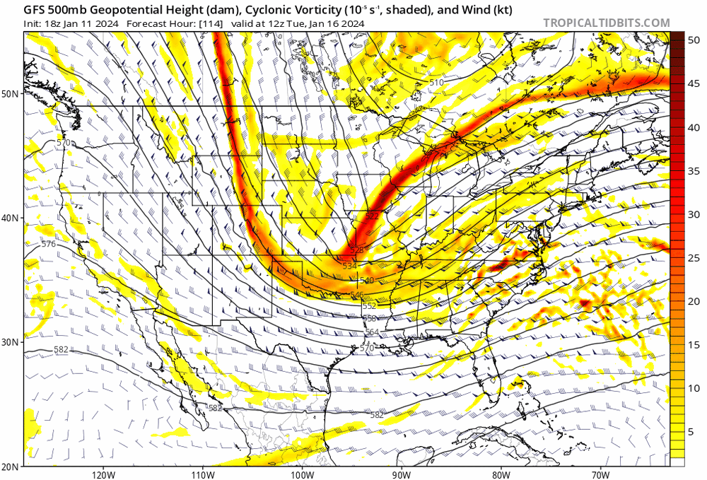
We lost that vorticity coming through the 4 corners region around 78-84 from the previous runs. That what pulled that trough down and without it we just flattened out.
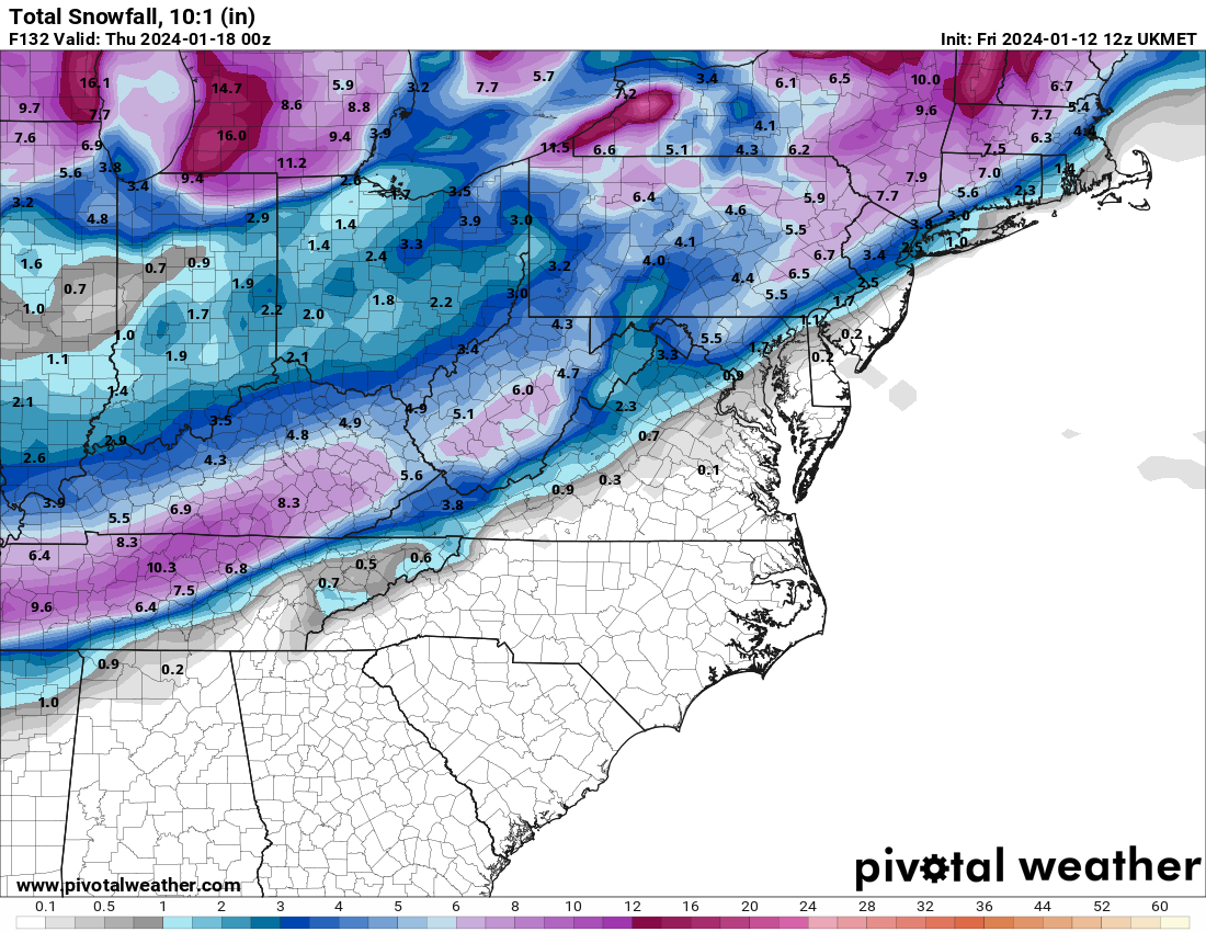

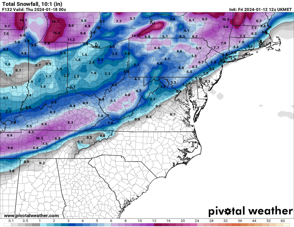
Jan 15-16 Storm Threat Thread: Do we finally win or get Saltburned?
in Mid Atlantic
Posted
It made a big jump on Tuesday though