NWAflizzard
-
Posts
147 -
Joined
-
Last visited
Content Type
Profiles
Blogs
Forums
American Weather
Media Demo
Store
Gallery
Everything posted by NWAflizzard
-
MO/KS/AR/OK 2020-2021 "Winter" Discussion
NWAflizzard replied to JoMo's topic in Central/Western States
That would be great! Thanks! -
MO/KS/AR/OK 2020-2021 "Winter" Discussion
NWAflizzard replied to JoMo's topic in Central/Western States
Black hills energy. They have not given an ETA as to when it will be back on. At least it will be in the teens today though. -
MO/KS/AR/OK 2020-2021 "Winter" Discussion
NWAflizzard replied to JoMo's topic in Central/Western States
So there is a gas outage in Pea Ridge. Kinda bummed out about that. -
MO/KS/AR/OK 2020-2021 "Winter" Discussion
NWAflizzard replied to JoMo's topic in Central/Western States
My Davis weather station shows -18. My little Lacrosse station shows -16. I can't believe it. I think that is an all time record if it is right. Maybe the extreme cold has broken my stations?? Edit: Shows -19 now!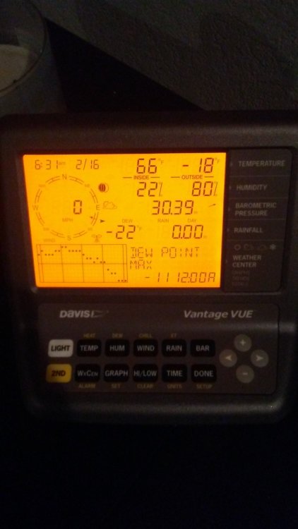
-
MO/KS/AR/OK 2020-2021 "Winter" Discussion
NWAflizzard replied to JoMo's topic in Central/Western States
I'm calling it a night. -8 here now. I think we will easily smash the February record low. I have to give the GFS credit. A week ago it was showing -15 for this area for around this time and I thought it was crazy. Turns out it was right. -
MO/KS/AR/OK 2020-2021 "Winter" Discussion
NWAflizzard replied to JoMo's topic in Central/Western States
-7 here. Really want to beat the record of -9. -
MO/KS/AR/OK 2020-2021 "Winter" Discussion
NWAflizzard replied to JoMo's topic in Central/Western States
I checked the NWS service records page for Bentonville. All time record low for February is -9. Low is supposed to be -11 tonight. I have -4 on my weather station right now. This cold is amazing! -
MO/KS/AR/OK 2020-2021 "Winter" Discussion
NWAflizzard replied to JoMo's topic in Central/Western States
We made it to 3 today which is 6 degrees short of our record low for the same day... -
MO/KS/AR/OK 2020-2021 "Winter" Discussion
NWAflizzard replied to JoMo's topic in Central/Western States
Our record low here for today is 9 degrees. Tonight our forecast low is -11. -
MO/KS/AR/OK 2020-2021 "Winter" Discussion
NWAflizzard replied to JoMo's topic in Central/Western States
Tulsa's new expected snowfall map. Seems a bit on the high end based on what I am seeing. At least for NWA. -
MO/KS/AR/OK 2020-2021 "Winter" Discussion
NWAflizzard replied to JoMo's topic in Central/Western States
New Winter Storm Warning issued by Tulsa mentions the power grid issue. 202 PM CST Mon Feb 15 2021 ...WIND CHILL WARNING REMAINS IN EFFECT UNTIL 9 AM CST TUESDAY... ...WINTER STORM WARNING IN EFFECT FROM NOON TUESDAY TO 6 AM CST THURSDAY... * WHAT...Dangerously cold wind chills thru Tuesday morning. Wind chills as low as 20 below zero. Moderate to heavy snow expected late Tuesday into Wednesday. Total snow accumulations of 4 to 9 inches. * WHERE...Portions of east central, northeast and southeast Oklahoma and northwest and west central Arkansas. * WHEN...For the Wind Chill Warning, until 9 AM CST Tuesday. For the Winter Storm Warning, from noon Tuesday to 6 AM CST Thursday. * IMPACTS...Travel could be very difficult. The very cold wind chills could cause frostbite on exposed skin in as little as 30 minutes. * ADDITIONAL DETAILS...Due to unusual demand on the electrical system across the region...rolling blackouts are possible. We are encouraged to find ways to conserve power over the next few days until the arctic cold leaves. -
MO/KS/AR/OK 2020-2021 "Winter" Discussion
NWAflizzard replied to JoMo's topic in Central/Western States
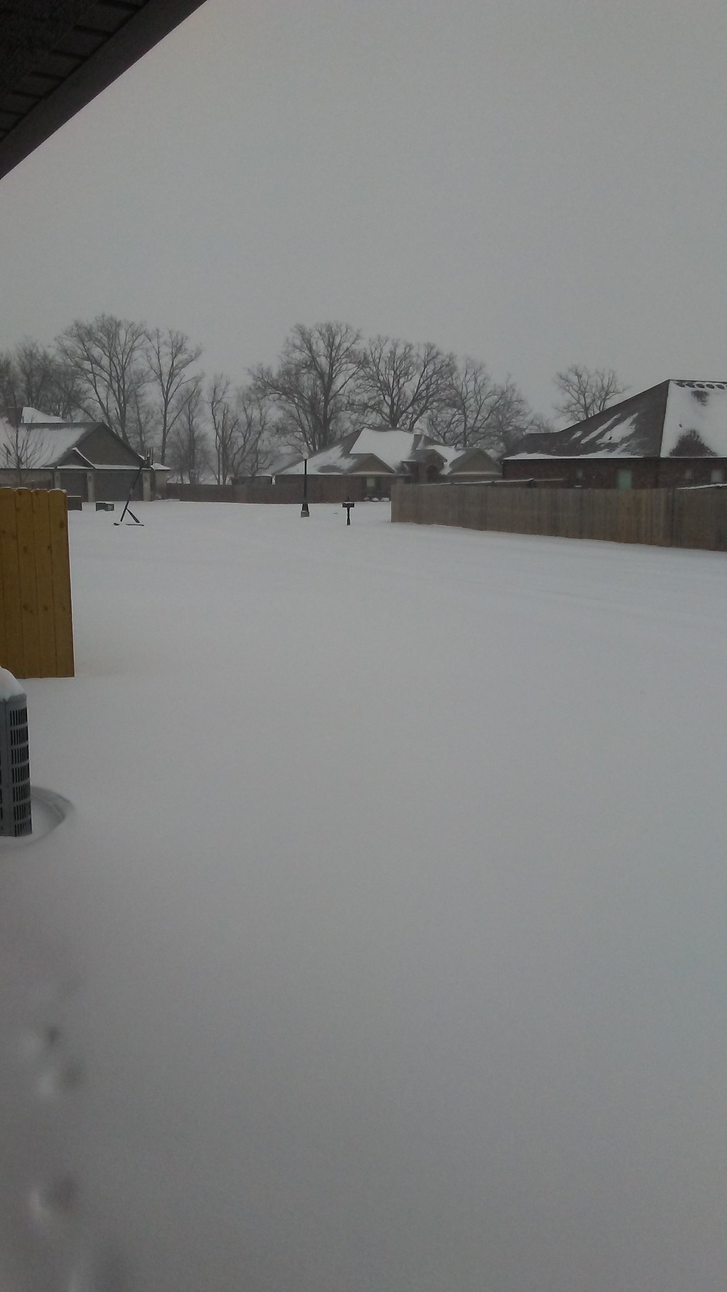
Here is a picture from this morning. We had around 4 then. I would say we have added at least 1.5 since. Sorry for the low quality. It was taken early.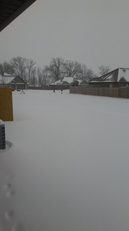
-
MO/KS/AR/OK 2020-2021 "Winter" Discussion
NWAflizzard replied to JoMo's topic in Central/Western States
It is really coming down here again. Bet we end with at least 6. -
MO/KS/AR/OK 2020-2021 "Winter" Discussion
NWAflizzard replied to JoMo's topic in Central/Western States
Measured 5 inches here too! Still snowing and blowing around everywhere. This storm was great! Looking forward to the next. Just hope I can stay awake. lol -
MO/KS/AR/OK 2020-2021 "Winter" Discussion
NWAflizzard replied to JoMo's topic in Central/Western States
We have 1.5-2ish. For someone from Louisiana this winter has been pretty epic. Been up here for 5 years and all the other winters have basically sucked. -
MO/KS/AR/OK 2020-2021 "Winter" Discussion
NWAflizzard replied to JoMo's topic in Central/Western States
I would say we have about an inch here. Hard to measure because it blows around everywhere. Streets are all covered. -
MO/KS/AR/OK 2020-2021 "Winter" Discussion
NWAflizzard replied to JoMo's topic in Central/Western States
Snow falling here being blown around by the wind. Smaller flakes with a few bigger ones mixed in. Sitting at 4 degrees. Now this is what I call winter! -
MO/KS/AR/OK 2020-2021 "Winter" Discussion
NWAflizzard replied to JoMo's topic in Central/Western States
Thought this update was interesting. Sounds like Tulsa thinks this could be big for the entire area National Weather Service Tulsa OK 1004 PM CST Sat Feb 13 2021 .DISCUSSION... Have updated snowfall amounts for tonight in areas to the northwest of I-44, as most recent runs of the HRRR and HRW suite have continued to focus the initial frontogenetic band of snow in the 06-12z time frame more to the north. Mid-level radar echoes have been gradually expanding across SW-central OK likely in response to this increased forcing. An environment characterized by steep lapse rates above the cold air at the sfc may be supportive of CSI in the elevated front zone, and thus some heavy banding of snow may occur late tonight into Sunday morning. The overall message of the forecast remains the same tonight as a significant winter storm is shaping up for a large part of eastern OK and northwest AR. Dynamic upper level system located near the Four Corners, which has produced numerous CG lightning strikes across NM/AZ this evening, continues to move east, and will provide a prolonged period of strong forcing over much of the area. North winds have begun to increase over the past couple of hours in response to the approaching system, with gusts around 25 mph becoming common across northeast OK. Wind chills have fallen below -5 in parts of NE OK as a result and while this is technically wind chill advisory criteria, this will be covered by the winter storm warning beginning at midnight. Higher dew points depressions seem to have cut off the lake effect snow across eastern OK, however sfc reports indicate there is still some ongoing in the FYV area...so have added flurries into the forecast for the remainder of the evening. Per satellite this appears to be mainly down wind from Beaver Lake. -
MO/KS/AR/OK 2020-2021 "Winter" Discussion
NWAflizzard replied to JoMo's topic in Central/Western States
Both 00z GEM and GFS still have the second storm. Wonder if the Euro will come on board. -
MO/KS/AR/OK 2020-2021 "Winter" Discussion
NWAflizzard replied to JoMo's topic in Central/Western States
Good luck everyone! Hopefully we all get something memorable! -
MO/KS/AR/OK 2020-2021 "Winter" Discussion
NWAflizzard replied to JoMo's topic in Central/Western States
Just saw that. Really upped totals across NWA and Southwest MO for that second storm. -
MO/KS/AR/OK 2020-2021 "Winter" Discussion
NWAflizzard replied to JoMo's topic in Central/Western States
Looks like the 12z GFS increased snowfall totals for Benton county during that first storm. -
MO/KS/AR/OK 2020-2021 "Winter" Discussion
NWAflizzard replied to JoMo's topic in Central/Western States
Same thing has been happening up here. We probably have about the same on the ground. Snowed lightly all day today and was blowing around everywhere. Very nice. -
MO/KS/AR/OK 2020-2021 "Winter" Discussion
NWAflizzard replied to JoMo's topic in Central/Western States
Just for laughs. This was the weather channel's temperature outlook for February. -
MO/KS/AR/OK 2020-2021 "Winter" Discussion
NWAflizzard replied to JoMo's topic in Central/Western States
Ok. I will cash out with that. No need for any additional runs. Thanks