

csnavywx
-
Posts
5,685 -
Joined
-
Last visited
Content Type
Profiles
Blogs
Forums
American Weather
Media Demo
Store
Gallery
Everything posted by csnavywx
-
Incidentally, this isn't the first setup like that this year. The one in January that produced a forced line of low-topped showers had a somewhat similar evolution (CAA and dry slotting aloft with some surface heating). It lacked the more beefy mid-level CAPE or it would have produced a similar result wrt wind damage.
-
Normally with that much shear and low cape, updrafts are simply tilted and sheared out of existence before they can do much. Yesterday was different. The total amount of cape was low (~500J/kg), but it was very low topped (around 450-500mb top, around -20 to -25C, just cold enough for charge separation and lightning) and concentrated. A more "normal" sounding with a higher top would've resulted in values 2-3x that large. That didn't matter in this case. The amount of instability was concentrated vertically and parcel acceleration was large enough to balance the shear somewhat and thus these shallower, but stronger updrafts could tap into the extremely high ambient helicity.
-
Should have a few more days of big gains from the remnant open water area in the Laptev, then a marked slowing as the Pacific side OHC remains high and the weather pattern turns hostile for growth.
-
Yeah, the transition time from supersaturated to undersaturated is very short, on the order of ~20 years and every one of those papers focuses on the 2030s as the onset date. 450ppm seems to be the threshold. It starts small in areal extent and depth, but once onset begins, it takes very little time to overtake virtually the entire Southern Ocean in wintertime and begins to encroach on mid-latitude waters with rather alarming speed. I can't imagine that's going to be good for some species (as the authors rightly point out). It also kind of forms a pincer, in that, species will be migrating towards the poles as acidification migrates towards the equator, putting the squeeze on species adaption.
-
You can always use Sci-hub! Chances are your taxes were used to fund the research anyways. (This paper has the following comment listed in acknowledgements: We acknowledge support from the National Science Foundation Ocean AcidificationProgram (OCE-1314209). This is IPRC publication no. 1152 and SOEST publicationno. 9508. )
-
Additional paper: https://www.nature.com/articles/nclimate2844
-
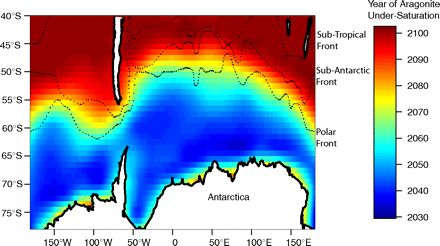
https://www.eurekalert.org/pub_releases/2019-03/uoaf-soa031119.php This is just concerning the appearance of a widespread undersaturation horizon near/in the mixed layer in the next 20 years or so. https://www.pnas.org/content/105/48/18860 It's an older paper, but we are very closely following the emissions scenario used (IS92a), so these dates probably aren't far off. Once aragonite undersaturation appears at the surface, it takes just 20-30 years for it to encompass basically entire Southern Ocean south of 50-60S. If we screw around long enough, by near the end of the century, that will spread towards the tropics and then calcite undersaturation will appear in the Southern Ocean. Once calcite is knocked out, you can kiss most shelled creatures goodbye. The thresholds for this seem to be at ~450 and ~650ppm. We're rapidly coming up on the first one.
-
I'm still reading through that paper. From what I've read so far, the change is on the order of 0.25 pH post-impact. We've had around 0.15 of change so far, but this hasn't eaten into the aragonite buffer enough to cause undersaturation at the surface or in the mixed layer in most locales so far. That is due to change sometime in the 2030s in the Southern Ocean and the waters next to Antarctica (where colder SSTs allow more gas to dissolve). From there it will spread rapidly across seasons and area. It's not talked about much and my suspicion is that it won't be until that starts to occur.
-
Looks like the ESS and Laptev are finally starting to freeze from both sides. That usually results in a quick jump in extent numbers as two ice fronts develop temporarily. Once that's done (by first or second week of Nov), the Pacific side will be the place to watch. Lots of heat to bleed off in the Chukchi and western Beaufort seas. Depending on how the weather goes, those might not freeze over until the new year. The southern Chukchi has a chance of not completely freezing over at all or only for a brief period in Jan-Mar. The warm water there is particularly deep this year.
-
And a frost free period of 85 days. Remarkable. One wonders what that's doing to the permafrost this year. Last few years the situation further south (near Fairbanks) has been bad enough that the active layer isn't completely refreezing during the winter, creating a layer of permanent thaw sandwiched in between. A situation which wasn't expected until quite a bit later in the century.
-
Nuclear would be significantly cheaper than trying to build out massive storage systems. While daily storage seems like a solvable problem in the medium term, seasonal storage does not. Baseload nuclear takes care of that pretty neatly and much sooner. Part of the reason solar and wind are so cheap is that they displace generation only at the margin and are at relatively low penetration. Once you get past a certain penetration (I believe 10-15% for solar atm), it becomes significantly more expensive because of the aforementioned intermittency problem. Wind is even worse, because (at least here in the US), climo wind peaks are in November and March, not exactly the time of year where you need power the most. As part of a legit climate plan, I'd be up for subsidizing and standardizing nuclear in a hurry. Build a bunch of standardized current-gen reactors and work on getting a standardized design for 20-30 years from now. It's probably the fastest way to bring emissions down. And we need speed -- the hour is late. We seem to be screaming along at 2.5-3ppm/yr, which is putting us dangerously close to a RCP 6.0-8.5 scenario through mid-century.
-
It looks cool over the central CAB the next few days at least -- before that small low gets nearly smashed into oblivion by the developing blocks and wave break over the Npac. The strong push of warm advection from the Russian side will keep this year in contention next week.
-
Wouldn't be shocked if we fell 300-400k behind by the end of that. There's some opportunity for catch up next week if that ridging shows up, but it does look like we'll slip solidly back into 2nd place.
-
While there's a lot of weak ice, there isn't quite as much as 2012, so I expect this year to fall slightly behind by the end of the first week of August. Maybe 200k or so. I actually think we could see record low volume, but come in second on extent and perhaps 2nd or 3rd on area. The MYI in the central CAB will undoubtedly make it, but given how warm winters have been the past few years, I expect it to start looking more and more like it did in 2016 at the end of the season, looking a little thin and ragged. Also, given how unusual this year's -AO pattern was (partially due to a dynamic final PV warming), I would expect a reversion to the mean next year. But this is the Arctic, and you never know....
-
A purely statistical model would have basically "missed" 2012 at this point. Probably 2007 as well. I suspect the issue has to with the behavior of extent numbers when volume gets very low.
-
This dipole will probably largely finish off the ESS, Chukchi and Laptev. Beaufort probably won't have much left either. Not looking great for the CAB either. Only the Atlantic side is doing okay this year.
-
Yeah, going to be tough to beat that early Aug. swan dive that 2012 had. Upcoming dipole might help give it a run for its money though.
-
The crazy thing is, with that temp trendline, this May-June period will be merely average by 2030-2035 -- though I would expect it to slow down after a while due to widespread melt moving earlier and capping temps near the melting point.
-
The classical dipole we tend to refer to typically means higher pressure on the Greenland/CAA/North American side of the basin and lower pressure on the Eurasian/Russian side. This results in a net wind and ice transport from the Pacific to Atlantic side of the basin. This typically causes high melt via transport of continental air over the central ice pack, compaction and export out through the Fram Strait and towards the Atlantic, where deep warm water makes quick work of even very thick sea ice. A reverse dipole is the opposite situation.
-
ESS is getting absolutely crushed. I highly doubt we see an ice "arm" there this year. Very impressive considering it started out in better shape this year. Doesn't bode well for CAB ice in that sector later this month.
-
Area loss was a bit slower, but still relatively high. Building up a lead on 2012 there too, though I expect it to be close again in 5 days or so.
-
Worldview looking worse and worse. Like 2012, the entire pack is riddled with extensive melt ponding, with no snow-covered areas left. We never quite get rid of that -NAO either and that's going to be a bit of an issue in the next week for the CAB and Beaufort in particular. It's not the raging dipole or warmth we've had, but it isn't terribly great either.
-
It's building up a lead in area and volume, so I expect it to be quite competitive even without a GAC
-
Mercifully, it appears the pattern is breaking down for real this time, though there's some question on where that TPV sets up. If it's closer to the pole, then we could see a decent slowdown. If it's over towards the Laptev, then it won't provide all that much braking action as the CAB, Beaufort and Chukchi are exposed (and that front is very weak this year already).
-
Yes, there does seem to be a relaxation of the hostile pattern in the cards in a few days. It doesn't exactly look cool, but definitely better than what we have now. In the meantime, area remains in freefall and will likely build up a sizable lead over the next few days. Volume is now at record lowest (as of the 1st). This year definitely has a real shot at the record. At the very least an easy 2nd or 3rd place.


