stormdragonwx
-
Posts
512 -
Joined
-
Last visited
Content Type
Profiles
Blogs
Forums
American Weather
Media Demo
Store
Gallery
Everything posted by stormdragonwx
-

MO/KS/AR/OK 2020-2021 "Winter" Discussion
stormdragonwx replied to JoMo's topic in Central/Western States
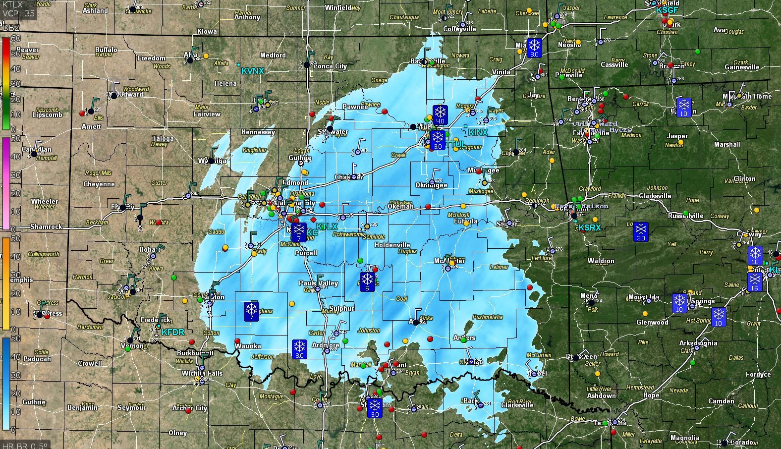
A new Winter Storm Watch already issued for the Tues-Weds system. https://forecast.weather.gov/wwamap/wwatxtget.php?cwa=tsa&wwa=winter storm watch "For the Winter Storm Watch, heavy snow possible Tuesday night through Wednesday night, with additional snow accumulations of 4 to 10 inches possible." -
MO/KS/AR/OK 2020-2021 "Winter" Discussion
stormdragonwx replied to JoMo's topic in Central/Western States
Officially contributed my report to NWS as of 1:45 am we finally broke 4" inches and it's 3 degrees above zero and dropping over here in the Fayetteville area. Snow winding down now. -
MO/KS/AR/OK 2020-2021 "Winter" Discussion
stormdragonwx replied to JoMo's topic in Central/Western States
Looks like the dreaded dry slot is taking shape sooner after all. -
MO/KS/AR/OK 2020-2021 "Winter" Discussion
stormdragonwx replied to JoMo's topic in Central/Western States
This. Things look to actually be trending up now. Unless we get a major dry slot punch, this is gonna deliver. This band really filled in and extends all the way out to Wichita Falls, TX with another band appearing to be developing out around Lubbock.
-
MO/KS/AR/OK 2020-2021 "Winter" Discussion
stormdragonwx replied to JoMo's topic in Central/Western States
Here's to hoping, otherwise I have to agree with NWWhiteOut, seems like so much wasted potential with the synoptic setup. -
MO/KS/AR/OK 2020-2021 "Winter" Discussion
stormdragonwx replied to JoMo's topic in Central/Western States
Yeah I just measured out where I am at, I only got 1.25 inches so far. -
MO/KS/AR/OK 2020-2021 "Winter" Discussion
stormdragonwx replied to JoMo's topic in Central/Western States
Yeah they just clarified this for me on Twitter. -
MO/KS/AR/OK 2020-2021 "Winter" Discussion
stormdragonwx replied to JoMo's topic in Central/Western States
Strange, TSA has apparently gotten gun shy with this system and cut down on the totals a lot. Wonder what's up with that. It's seems like someone thought this mornings snow was the main event.
-
MO/KS/AR/OK 2020-2021 "Winter" Discussion
stormdragonwx replied to JoMo's topic in Central/Western States
Yeah it's definitely a fine dry powdery snow for sure. Not the big wet clumpy flakes we are used to. That should change later. This is again only wave #1 looks like there's 2 or 3 more waves that extend all the way out to El Paso. -
MO/KS/AR/OK 2020-2021 "Winter" Discussion
stormdragonwx replied to JoMo's topic in Central/Western States
Looks like some of that snow is convective in SE OK. Can anyone confirm?
-
MO/KS/AR/OK 2020-2021 "Winter" Discussion
stormdragonwx replied to JoMo's topic in Central/Western States
00z Euro coming in now. -
MO/KS/AR/OK 2020-2021 "Winter" Discussion
stormdragonwx replied to JoMo's topic in Central/Western States
As of right now I can report a decent bit of flurries in east Fayetteville still ongoing here the main system hasn't even arrived yet. Its blowing all over the streets too. Grass is almost covered. EDIT: Found this on Twitter. Same thing happening over by Oologah is happening here. -
MO/KS/AR/OK 2020-2021 "Winter" Discussion
stormdragonwx replied to JoMo's topic in Central/Western States
Yeah I just want one good snowstorm where I can say it snowed me in before we get into severe wx season. -
MO/KS/AR/OK 2020-2021 "Winter" Discussion
stormdragonwx replied to JoMo's topic in Central/Western States
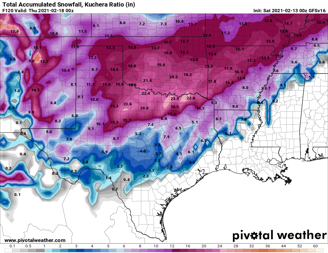
Here's the GEM-GDPS after that 2nd system rolls thru using Kuchera. -
MO/KS/AR/OK 2020-2021 "Winter" Discussion
stormdragonwx replied to JoMo's topic in Central/Western States
FWIW as I mentioned a few pages back, I don't really trust the NAM at all, most notably after how it initialized a few days ago saying it was in the high 30's when it was already 28. And as others mentioned the CAMS are not always the best with winter weather. The GFS, v16, GDPS, and Euro have stuck to their guns on this event for the most part. -
MO/KS/AR/OK 2020-2021 "Winter" Discussion
stormdragonwx replied to JoMo's topic in Central/Western States
Those were with the PC but I've done it with my Android its just a bit trickier to accomplish. You have to tap and hold the white area at the top of the graphic to get the "save image" option with mine. -
MO/KS/AR/OK 2020-2021 "Winter" Discussion
stormdragonwx replied to JoMo's topic in Central/Western States
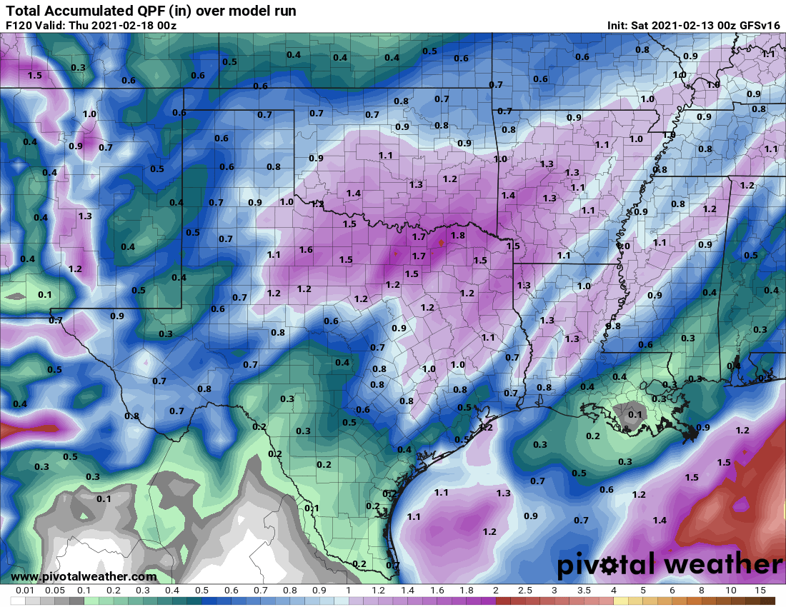
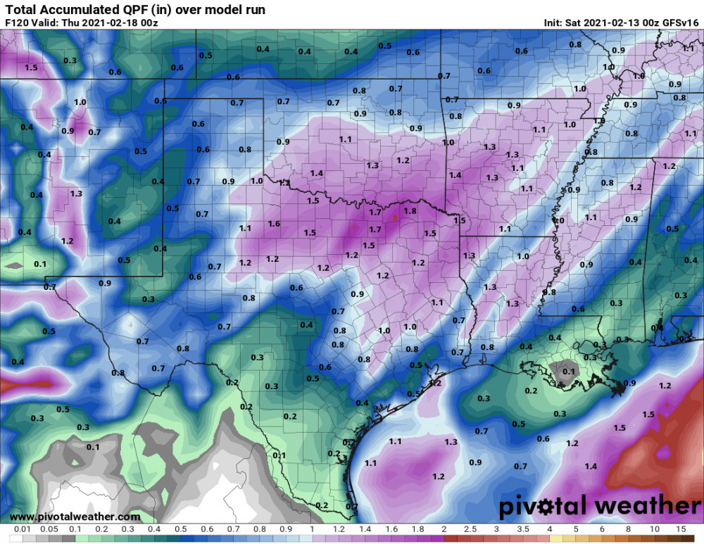
QPF between GFS and v16 120 hours out. EDIT: 150 hours out quickly shows nearly 2 inches of QPF https://www.pivotalweather.com/model.php?rh=2021021300&fh=150&dpdt=&mc=&r=us_sc&p=qpf_acc&m=gfs_para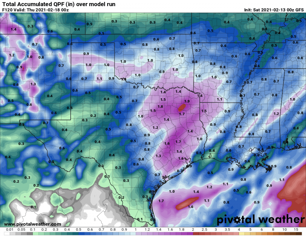
-
MO/KS/AR/OK 2020-2021 "Winter" Discussion
stormdragonwx replied to JoMo's topic in Central/Western States
You're welcome. lol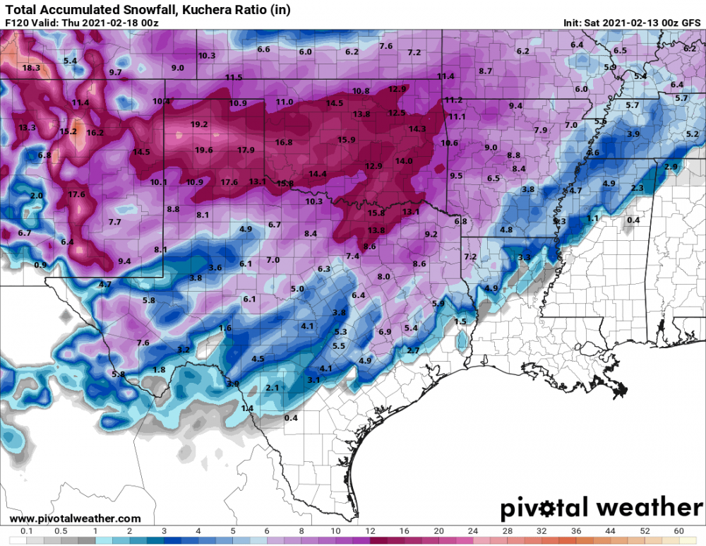

-
MO/KS/AR/OK 2020-2021 "Winter" Discussion
stormdragonwx replied to JoMo's topic in Central/Western States
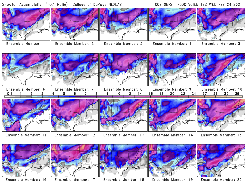
Agreed its totally weird. We get one anomalous once in a decade event like in 2011 then shafted the rest of the time. For us NWA folks I'm holding out hope on the GFS Ensembles. As far as I have seen every member on every run shows us getting at least 6 inches. Here is the 18z, only one that scares me is #2 lol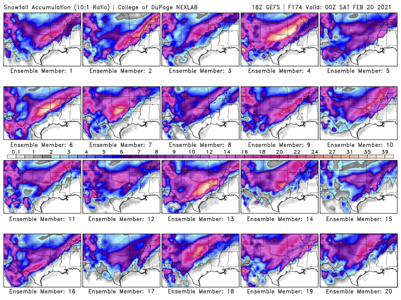
-
MO/KS/AR/OK 2020-2021 "Winter" Discussion
stormdragonwx replied to JoMo's topic in Central/Western States
Heck I saw on one of the Canadian models a couple days ago a perfect little bullseye of nothing over Benton and Washington counties while everyone all around received a foot. -
MO/KS/AR/OK 2020-2021 "Winter" Discussion
stormdragonwx replied to JoMo's topic in Central/Western States
Kinda starting to look like it.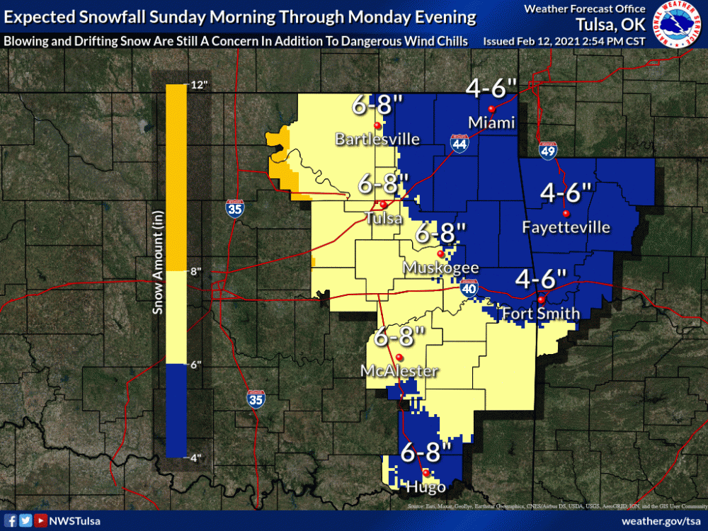
-
MO/KS/AR/OK 2020-2021 "Winter" Discussion
stormdragonwx replied to JoMo's topic in Central/Western States
I kinda got a feeling like what another poster mentioned "Lucy" might indeed pull the football at the last minute. I just can't help not liking the trends today. I was really hoping this storm would give 2011 a run for it's money for NWA. Guess we will see in 36 hours or so. -
MO/KS/AR/OK 2020-2021 "Winter" Discussion
stormdragonwx replied to JoMo's topic in Central/Western States
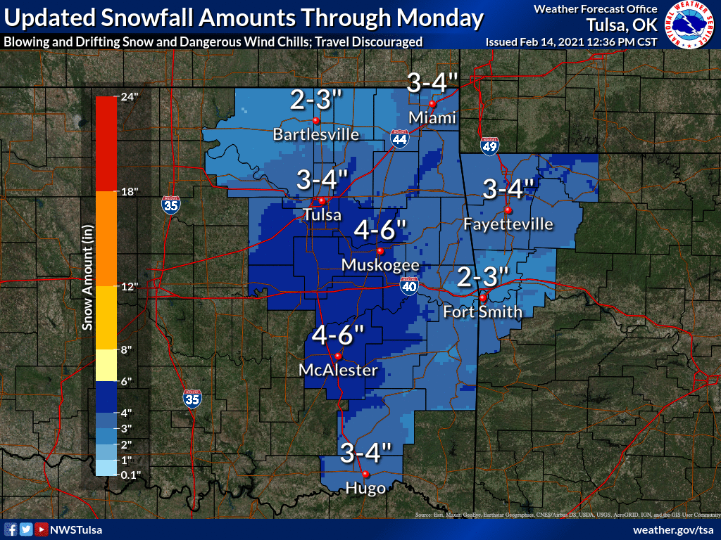
Fair enough. TSA is pretty well known to being conservative on their forecasts. Still crazy to think 14in is being "conservative" here though. -
MO/KS/AR/OK 2020-2021 "Winter" Discussion
stormdragonwx replied to JoMo's topic in Central/Western States
^That still pretty much lines up with TSA's DSP page as it currently sits at this time. -
MO/KS/AR/OK 2020-2021 "Winter" Discussion
stormdragonwx replied to JoMo's topic in Central/Western States
Thats crazy, all the GFS ensembles still showing the area getting slammed.