

Snownado
-
Posts
440 -
Joined
-
Last visited
Content Type
Profiles
Blogs
Forums
American Weather
Media Demo
Store
Gallery
Posts posted by Snownado
-
-
16 minutes ago, fluoronium said:
Started as snow here! Most guidance had at least a couple hours of rain before switching over so this is a good sign. Wind still coming from the south.

not even a single report of rain nearby!! Awesome!
Is the area of green not representative of rain ?
-
Aren't the areas with the heaviest snow often near the cutoff ?
-
2 minutes ago, Jackstraw said:
Parents lived on Sullivans Island since 84, I lived in Mt. Pleasant for 12 years, left in 2012. Like anywhere else it's changed a lot but it's still a great area to live. Got 5 inches of snow down there in like '08, biggest snow in a century or something. Brought the entire area to a standstill literally for 2 days lol. I go down there at least once a year,. Get used to this winter we've been having because this is low country winter minus the snow lol.
Maybe it's none of my business but why on earth would you move from beautiful Charleston, SC to the boring, flat cornfields of Central Indiana?
-
 1
1
-
-
2 minutes ago, WeatherMonger said:
WPC 4" probs

Seems a bit conservative doesnt it ? I would think the Indy area has a greater than 10% chance at 4". NWS has me at about 5" in the hourly grids.
-
I have a hard time believing 6-8" for Indy with marginal temps. Going to be too much mixing. Does anyone on here think any of the Indy metro has a shot at 6-8" ?
-
7 minutes ago, Jackstraw said:
One can dream lol
I may need to come stay at your house. Im in Carmel and not expecting much if anything here.
-
 1
1
-
1
-
-
3 minutes ago, Jackstraw said:
I live about 50 miles N of I-70 which always puts me in a white knuckle slop zone as opposed to closer to I-70 where it can be a little more cut and dry. I agree the potential for seasonal repeat is there but this one is a bit different than the past few with, albeit coming in later, cold air to work with, the warm nose doesn't have the northward push as the past few systems and we're not going into it with 40-50 degree temps prior. Most of the models have warm 850's to my south some as close as 5 miles lol. 2m temps may be at or just above freezing on the onset but I've noticed the models have been over doing 2m temps the past couple storms. Get some decent heavy precip rates at the onset could negate that along with cloud cover and previous lows in the mid 20's. I also have a classic forecast office battle going on with KIND going 1-3 and IWX going 3-5 two miles to my north.
I'm going all in with the short this season calling 6-7 through Thursday afternoon.
 If that all sounds like someone in denial, well yeah lol! Long term this looks like my last hurrah except for a late season long shot big dog so why not
I bet you will see subzero temps on Fri morning with all of that snowcover.
-
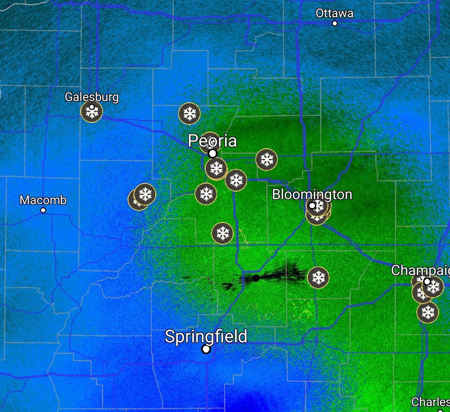
Winter Weather Advisory for Central Indiana.
-
1 minute ago, StormChaser4Life said:
18z nam gives me some hope. Warms me to 35 by midday then starts the plunge. Keeps precip all snow. Obviously accumulations will be limited at first with marginal temps and very low ratios but should improve come Wed evening and overnight
The dreaded sun angle will hurt daytime accums also. Remember it's Mid Feb not Mid Jan.
-
I am just north of Indy in Carmel. Im hoping to see at least a couple inches out of this. It's been a very depressing winter. I wonder if theres any chance advisories or watches will be issued today ? Also I bet the lows will trend even colder with the arctic air if there is snowcover. Weather.com has me at 0 on Fri morning.
-
It's 2pm and still no sun despite a partly to mostly sunny forecast. It's unreal how difficult it is to get sun around here.
-
42 minutes ago, nwohweather said:
Just beautiful. To be fair I’m moving to Charleston in a month so I’m owed a solid snowstorm hahaSC or WV?
-
4-5" of snow in North GA today. Why can't the I-70 corridor get that type of snow ?
-
1
-
-
5 minutes ago, HWY316wx said:
It can when it looks like this.
The line of disappointment will be sharp today in GA.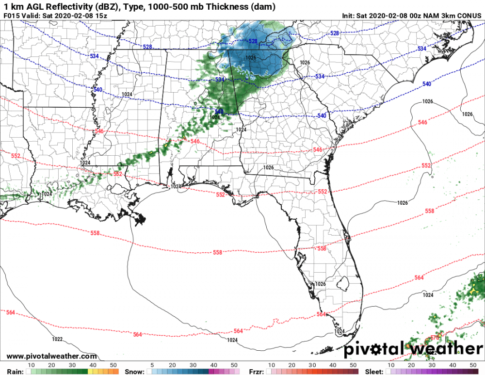
I would definitely be excited if I was in Canton or Cumming but it looks like most of metro Atl will get mostly rain. The good news is that for snow starved Atlantans, the snow is just a short drive away.
-
Sure is a sharp cutoff. Cherokee and Forsyth under Warnings and the airport isnt even under an Advisory. Can 40 miles really make that much of a difference ?
-
43 minutes ago, PowellVolz said:
Sun angel at the first of February?
.The sun angle is much higher than it was in Dec. Its equivalent to around the beginning of Nov now.
-
 1
1
-
-
I worry about precip rates tomorrow. The snow is going to have to come down very hard for it to accumulate with such marginal temps.
-
Im skeptical about much in the way of accumulation outside the higher elevations in GA. Even Gainesville should be in the mid to upper 30s most of tomorrow.
-
1
-
-
6 minutes ago, buckeye said:
GW
everything is shifting north. We're like Nashville now. Can't wait til Josh has to go through a 'columbus-esque' winter.... it's coming Josh...it's coming

Hopefully it keeps up.... wouldn't mind a solid Atlanta-type winter pattern in the future...I'm getting too old for the cold
I dont mind the cold so much. Its the endless days of cloudy weather that depresses me.
-
1
-
-
4 minutes ago, michsnowfreak said:
Fair point, esp regarding temps (avg snowfall is 6.9"). But i think of april as the bigger transition month. April is a month that most years has both days with snowflakes and days where it feels like summer. But in terms of looks, outside of 2012, march landscape definitely looks more like winter than spring.
730-8 pm sunsets make March feel more like spring than winter i think.
-
1
-
-
13 minutes ago, michsnowfreak said:
March is overwhelmingly a winter month here.
More like a transition month I think. Detroit's average high temp is 10+ warmer in March than Feb and average snowfall is a lot lower in March.
-
1
-
 1
1
-
-
28 minutes ago, nwohweather said:
What a remarkable day outside. Only really two months until Spring guys
2 months ? Met Spring begins in 26 days
-
2
-
-
16 minutes ago, buckeye said:
More salt in the wound:
If cincy is at .6" so far for the season, they are tied with DC.
 Not the kind of clique you want to be in when it comes to snowfall.
Cincy has had over 6" this season I believe.
-
When people say we get our best snows in March i think they are full of BS. Whens the last time there was a widespread March snow from Birmingham to Raleigh ?

Feb 12-13 Snowstorm
in Lakes/Ohio Valley
Posted
36 with flurries in Carmel.