

Its a Breeze
-
Posts
299 -
Joined
Content Type
Profiles
Blogs
Forums
American Weather
Media Demo
Store
Gallery
Posts posted by Its a Breeze
-
-
On 10/4/2023 at 8:51 PM, WxUSAF said:
So far I’d say October’s going to look nationwide more like the warm version on top than that frigid version on the bottom even if we have a chance at a BN month.
On 10/4/2023 at 9:27 PM, Ji said:
Yep we got some work to do to get that blue lolGFS says - say no more:

-
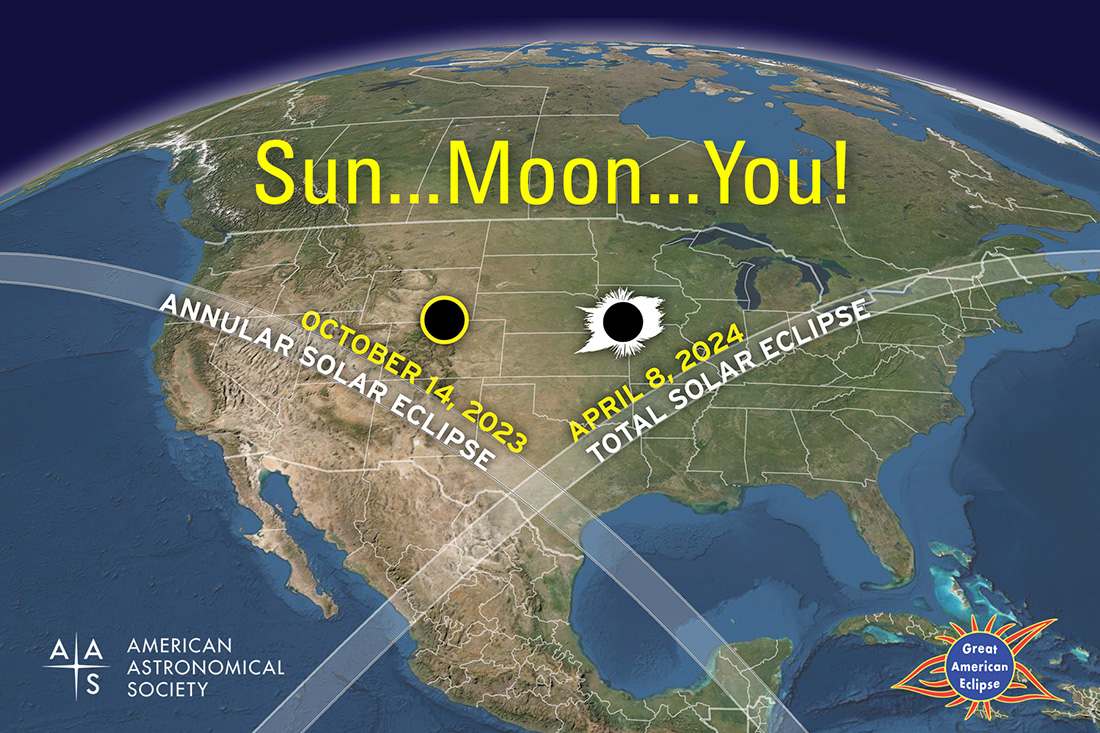
Just a FYSA for any chasers this year or next -
-
 3
3
-
-
On 9/30/2023 at 6:52 PM, RodneyS said:
September 2023 at DCA came in above the 1991-2020 normal, at 73.4 degrees.
Which is incredible. 5 days (3rd - 7th) were so above average, that it made the whole month above normal.
Had those days been 'normal', we would have been below average for the month.
-
In the Commander's loss, I'm comforted (not really) in the fact that, it was just about the only normal thing to happen this NFL week. Wow...
-
8 hours ago, WxWatcher007 said:
WxWatcher007 Peak Season Forecast (Aug 20-Oct 20)
Named Storms: 13 (11)
Hurricanes: 6 (5)
Major Hurricanes: 3 (3)Emily, Franklin (MH), Gert, Harold, Idalia (MH), Jose, Katia, Lee (MH), Margot (H), Nigel (H), Ophelia
Perfection is within your reach! Good stuff.
-
1
-
-
19 minutes ago, Jebman said:
Someone is gonna get demolished.

I mean, it'll be like an hour of moderate rain yeah, but demolished?
-
 2
2
-
 1
1
-
-
33 minutes ago, jewell2188 said:
I’d put money on 1-2 inches area wide. But is the most exciting tropical since Isabel lol
Not sure about that. Irene I think will beat this one out.
-
9 minutes ago, vastateofmind said:
So, for those who were here back then...does Ophelia fall just short of being as impactful as Isabel in 2003 in terms of rain or wind? Or not even close? I've seen a few historical charts that showed Isabel dropped 1"-3" in the metro area, but the winds (I think, or at least remember) definitely had in impact in the area.
It's definitely going to end up in the not even close category in terms of winds as Isabel had much stronger winds and much stronger winds over a wider area.
-
1
-
-
4 minutes ago, TSSN+ said:
75kts FL, 60-65kts surface. Should be at 70mph probably now. Definitely think hitting a cane is not out of the question now.
Don't know. She's a bit wild, exposing herself to all right now. She needs to get her life together a bit more before hitting rock/bottom of the outer banks...
-
1
-
-
20 minutes ago, SnowenOutThere said:
It then proceeds to hang around combining with another system so it can continue to rain on us till the 5th. Though unlikely to be right I desperately hope its wrong, I can barely stay awake in school when its sunny out and if its cloudy all bets are off.
What?
Who doesn't like a week straight a raw wetness with a NE breeze?
-
Model agreement


-
4
-
-
I'm Ron Rivera's Washington Commanders. Late season runs that looks promising, but ultimately falls short

-
3
-
-
Preliminary but - Ugh, heartbreak. Looks like BWI hit 100 shattered any slim chance I had....
Congrats @WxUSAF with the near perfect score

-
 1
1
-
-
1 hour ago, wxdude64 said:
Those ARE the temps you are looking for....
Yes, and it looks like RIC came through! Don't know when it's official, but I'm seeing 100 at 3:10. Now...don't go any higher please

-

Help me Richmond, you're my only hope...
-
So hear me out....
RIC is technically in southern Virginia, and therefore should not count. Also, with Labor Day being the end of summer, we can ignore any subsequent readings and close the contest as of yesterday.
-
2
-
-
6 hours ago, WxWatcher007 said:
We can thank Franklin for nearly single handedly accomplishing this
")
He was getting a bit long in the tooth there.
No longer tropical but it's fascinating watching Jose get absorbed into him. We don't see two named systems collide very often! Maybe we can get all four to kinda squish together...
-
1
-
-
3 hours ago, RIC_WX said:
Haven't most of the forecasted heat waves this season failed to deliver? What makes this one different?
It certainly hasn't reached the temperatures that the models (specifically the GFS) have shown. But for the most part, the idea of it getting warmer has generally come to fruition...
-
Looks like we'll have another chance next week to hit some of those numbers. Maybe.
Likely a good chance that this'll be our last shot.
-
14 minutes ago, midatlanticweather said:
Not sure I am seeing things right, but it seems we had a little more North Northwestward jog based on satellite images. Anyone else see this? It is not too significant, but could have some implications!
Hard to tell. It looks like a bit of dry air is trying to intrude right now which may be responsible for any slight jogs. And we'll see if that temporarily stems any rapid intensification for the time being...
-
1
-
-
20 hours ago, mattie g said:
Hindsight is 20/20, but we had all kinds of folks on here stating that they didn't think NHC should have doubled down on their call for an above-average season. I didn't point it out at the time, but it always amazes me when people think they know so much better than experts.
Experts can be wrong, of course, but it seemed pretty obvious that they were confident coming into mid-August despite the basin looking dead for a long time prior.
Low end, for the NHC forecast to be on target we'll need the vast majority of the 5 more named storms, 4 of which become hurricanes, in the next couple weeks. High end, we'll need the majority of the 12 more named storms and 9 more hurricanes in the next couple weeks.
Sure we can do the low end, it's just that in an El Nino year, it's not going to get easier moving forward. We're up against time.
For Colorado State - we need 9 more name storms and 7 more hurricanes.
Tough ask.
****
Edit to add -
Franklin is absolutely magnificent right now. Beautiful storm.
-
I didn't do too bad this year.
Next year, I do not think we'll be as fortunate in being this "low", but we'll see.
-
1
-
-
12 hours ago, Stormchaserchuck1 said:
I personally didn't like 09-10 so much because the snow melted so fast. We were due for a record setting snowfall in the right pattern since low pressures have gravitated off the coast since year 2000, but these Pac warm air blips quickly following a trough had our blizzards mostly melted in ~3 days. I know most people here love numbers, but these quick variations back and forth with the pna (like today) would give us some warmer air the Wintertime post-storm to melt newly fallen snow. Just initializing out.
You've said this before and, nothing has changed. It still remains 100% false.
Dec.'s snow lasted til Christmas. Then we had snow on the ground from late Jan to late Feb. We were below average nearly the whole month of Feb.
-
1
-
-
7 minutes ago, yoda said:
Now this is pretty cool
Very cool indeed. I'm like a couple weeks late, and don't have vid/pic proof, but the last time we had thunderstorms around here I saw one!
Took the dog out and as I'm waiting, I felt a couple drops. Looked up. Completely clear skies overhead. Didn't have to wait long to see flashes of lightning on the horizon though. I kept looking up because...that was cool! The clear sky would occasionally light up and a drop here and there from seemingly nothing. As I'm looking up there's a brief, streaky/stringy but very clear flash of red. My first thought was 'Wow a sprite!' Right? The Perseids were going on so then I briefly thought, or maybe a reddish meteor entered weirdly? But quickly dismissed that. Youtube'd a couple videos to confirm. Definitely a sprite.
-
2
-
November Discobs 2023
in Mid Atlantic
Posted
32.7 this morning. Going to go ahead and round down, and count it as a freeze")