
.jpg.2498e782e3b3ce7eeb1160d3454b2ebc.jpg)
Gino27
-
Posts
540 -
Joined
-
Last visited
Content Type
Profiles
Blogs
Forums
American Weather
Media Demo
Store
Gallery
Posts posted by Gino27
-
-
Messy convection in IL and moisture staying south. I think the main threat will line up more into Kentucky.
-
22 minutes ago, buckeye said:
clearing coming in from sw. We'll see if it holds
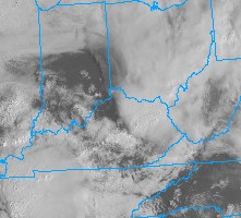
Clouds look to be closing off the clearing rather quickly from the rain in KY/TN. Question will be whether that serves to hold off premature convection or shunts everything altogether.
-
Somewhat of a surprise 2” system this morning. Thought we were done lol
-
KCMH reported 4.4” soo the streak goes on, but what a storm. I got around 5.5” near OSU campus, but a lot of my friends just 15-20 miles north got 6”-8”. Crazy that just 24 hours before the snow fell ILN has us at less than an inch.
-
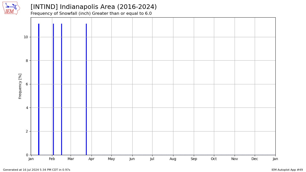
Columbus could break its 9 year no snow over 6” streak!
-
 3
3
-
-
The radar looks pretty beefy out west and a bit more north than the HRRR and NAM. Our high temp will be important in deciding accumulation efficiency today.
-
Looks like a pretty broad 1-2 event tomorrow. Might be limited by warm surface
-
-
1 hour ago, buckeye said:
How is this even possible.....??????
 edit: to clarify this is in Ohio

They have a cooling tower for their snowmaking water supply. It's a really impressive setup and can cover the entire hill with just a 48 hour window of below 30 degree temps.
-
1
-
-
28 minutes ago, buckeye said:
Yea about the same in Westerville. The last few years our climo has been like Nashville without the ice storms.
I finished up around 1.9" and could get more overnight, but yes we have had a more Nashville like climo. However, from those plots I've been sharing in the banter thread, Nashville has gotten a handful of big storms while we haven't.
-
36 minutes ago, buckeye said:
I also thought Indy was our sister city in winter futility.
They did really well in the Feb 15, 2021 storm where they reported 6.8" and the Feb 3, 2022 where they reported 7.3"...along with a handful of others during the same time frame. Just in Ohio both Cincinnati and Dayton have also had multiple 6"+ storms during this time as well.
-
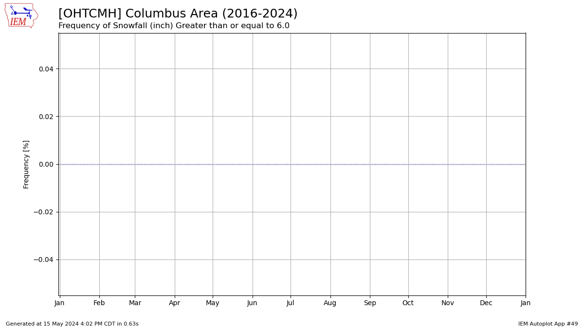
With the warmup coming, it seems likely that Columbus's drought of winters without a 6"+ snowfall will reach 9 years. Last time was Feb 21, 2015. I've played around with plotting for cities in our region and have only found Louisville, KY to have a drought this long.
-
I measured 1.5" around 9am on OSU campus. This one didn't quite produce
-
1
-
-
Wilmington having a pretty sharp cutoff between the 1-2 and 3-5 areas. Should still be a nice event.
-
23 hours ago, Gino27 said:
Seems like a nice high ratio hybrid clipper is possible Thursday-Friday. Personally these are some of my favorite events, but with everything this winter I could see it going poof soon.
Sure enough later runs are going poof
-
Seems like a nice high ratio hybrid clipper is possible Thursday-Friday. Personally these are some of my favorite events, but with everything this winter I could see it going poof soon.
-
2
-
-
2 minutes ago, buckeye said:
yep. I have a feeling this coming 'cold shot', (which isn't anything other than a typical severe cold shot we get every winter), will be all she wrote. I'm not buying the rock'n FEB bs. This is why I've slowly de-coupled myself from the winter wx aspect of this hobby the last few years. Sure, I still love severe wx events, but I'm thinking of changing to a new hobby, one that has a better chance of scoring than a central Ohio snowstorm. Gonna join the local Big Foot spotters club.
It just seems like each winter gets more futile than the last, but it also seems to all be bad luck. One storm goes east, the next to NW, and potentially one to the south feels like crappy luck instead of genuinely bad patterns.
-
1
-
-
1 minute ago, zinski1990 said:
Central Indiana is a snow repellant man. So sick of this
Seems the same in Central Ohio too. We haven't had a good I-70 track in too long.
-
57 minutes ago, dilly84 said:
Not strong enough? It's sub 980. NAM has it at 969mb
Even a sub 980 storm positioned just north of us will not have dynamics or moisture to support good snow around our area
-
4 hours ago, vespasian70 said:
If this bombs out like the 00Z GFS showed it will certainly be way west of Central OH. We need a weak sauce solution for good snows here with this one ... unless the "bomb" produces a mighty backend snow.
It seems likely this one misses just NW and isn't strong enough to give us any backend snow. Then the follow up wave early next week gets suppressed...
-
Right now the shifts have been more to the NW of a lot of us. With two waves still being modeled beforehand, I imagine we will see a lot of shifting. With that being said we have all the ingredients for a big Ohio Valley storm
-
30 minutes ago, iluvsnow said:
Based on the synoptic set-up, after Tuesday's rainer.....we have opportunities for some dogs.....maybe even some big dogs if timing and wave placement works out the rest of the month. Someone will cash in. The Ohio Valley is due.
Potential is surely there with PV love and active pattern. Hopefully we can all cash in
-
2
-
-
The previously unmodeled shortwave that’s coming onshore around 6z Friday is spoiling the show. Doesn’t let the low amplify leaving us in the dry
-
Already scared it away

4/1-4/2 severe threat (southern portion of subforum)
in Lakes/Ohio Valley
Posted