

Prospero
-
Posts
1,162 -
Joined
-
Last visited
Content Type
Profiles
Blogs
Forums
American Weather
Media Demo
Store
Gallery
Posts posted by Prospero
-
-
2 minutes ago, Rjay said:
Seems like more than just the mayor messed up here.
Maybe the wise have left, the traffic jam has subsided, and NOW is the time to say, "Get outa Dodge!!"
-
2 minutes ago, KPITSnow said:
Did you just say Katrina didn’t live up to the hype???
Historically yes it did.
It took a while for it to manifest. But hey, I was watching weather channel and landfall was not what we were expecting. The after effects were more than anyone imagined.
-
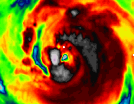
NOW there are two eyes...and a crooked mouth! And wild hairdo.
-
 1
1
-
-
Just now, JC-CT said:
Yep...RI and transformation into the beast happened during the overnight. It was a cat 1 before then.
I was obsessed on another forum (being me), remember the "eye" discussion as it left the Florida coast when everyone thought it would develop much earlier. But reminded of the eye getting it together seeing the clip. Wow, so many storms since then.
But if I remember right, it never reached the hype level even though being devastating to New Orleans. I do remember a horrible storm surge I think around Gulfport, MS.
-
 1
1
-
-
11 minutes ago, JC-CT said:
Yes...
24 hours yes. What a monster it was.
Eye was a mess where Ida is now. We'll see what happens. Hopefully NOT a Katrina.
Good post. I'll pull back before I get banned off banter.
")
-
 1
1
-
-
1 minute ago, JC-CT said:
Katrina had a nearly perfect eye for like 24 hours before landfall
24 hours? Not what I remember. But it did spin off-shore a bit.
-
Ida, she/it is trying like hell to get that hot energy from the Gulf into the atmosphere where it belongs.
What is the the cool spot? Dry air??
-
7 minutes ago, Tezeta said:
You’re referring back to wx mod, huh? If I wanted to do it, I’d start with trying to keep the eyewall open. But recon confirms a closed eyewall anyways, something we don’t see on IR. Also, why didn’t “they” stop Michael? It ruined an Air Force base and damaged some seriously expensive assets.
Mostly I see what I see on the Texas coast. Katrina caught me eye first. But ever since.
Just observations, from a storm passionate guy. But years of patterns support what I see. Not always, but in the Gulf it has become a storm forum dialog of "I see and eye" and "Nope, not yet."
Ida will be strong no matter what. But didn't we all expect a well-defined perfect eye by now with wrapped around convection?
Yes most of us. I have been here for days. Last night going to bed people were talking about the "six hours" from midnight till 6 am.
Ida is a powerful dangerous storm indeed, no matter what. But I say the eye will be jabberwocky until a few hours before landfall like Katrina and Laura, some others that we have watched.
Maybe if this keeps happening others will wonder WTF is going on. I will accept the weenie crazy hat and actually used to it.
Any bets when a Yucatan perfect eye will form with Ida?
-
2 minutes ago, Hotair said:
Come Monday many folks in LA will be saying “if I’d known Ida was gonna be this bad Ida gotten outta here”
ill let myself out
Many will be. Others who live on higher ground in new fancy areas will complain and not leave when they should the next time.
Happens here in Florida too often.
I don't think it will be as bad as the hype, but certainly could be worse then the dismissers.
-
My prediction.
We will see this happen until close to landfall.
I have my opinion and not sharing because it starts a fire every time I suggest it and we do have an active storm. But come on. Really?
-
2
-
-
This is why I love the banter. More opinions and observations, and passion.
I agree Ida may reach its potential, but a Major by noon today faded away. And still weird issues in the convection around the eye all day that throw it off.
Yet if this same storm was heading to the Yucatan the eye would be perfect totally surrounded by solid convection. We'd all be talking about that.
Why do Gulf storms have breaks in the convection? Consistently. Tell me.
-
I bet if I watch a five hour sat animation I will see random cold spots appear where solid hot convection should be happening. Of course random scientific explanations suggestion a dry air pocket from somewhere or some other weird reason why a perfect eye won't come together.
Another Gulf storm with an eye disease. But its early and I'll watch. Plus I have hundreds of posts to read to catch up!
")
-
1
-
-
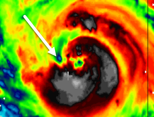
Just looked at the sats before I read the Ida storm thread.
Eh, yea, not what I was expecting. NOT a Yucatan eye, but something there. Not perfect but maybe it was this afternoon.
-
1
-
-
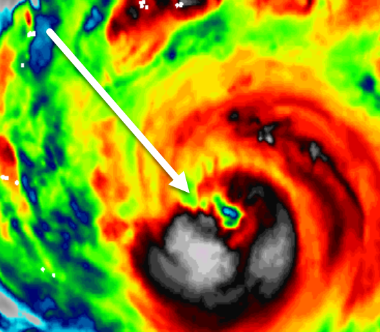
Wow, five hours offline and the Ida banter thread has gone crazy! Will take a while to catch up. Haven't even checked the real Ida thread!!!
Is there an eye??????
-
2 minutes ago, Tezeta said:
Indeed. They weren’t lying when they said climate change is going to cost trillions. What’s nuts is that Louisiana is a relatively cheap example. The east coast of Florida will one day have its hurricane barrage and that will be so much worse.
We've been very lucky around Tampa Bay. VERY lucky.
-
5 minutes ago, Tezeta said:
She’s looking better in the last two minutes than she did 7 minutes ago tho
Its going to be a long day. LOL
Luckily for me I'll be on the road a few hours away from my PC.
-
I think Ida looked better an hour and half ago. Maybe just me.
Will Ida have a well-defined eye by noon EST? I have my doubts.
-
9 minutes ago, Bostonseminole said:
And that is without a Mandatory Evacuation. Oh what fun.
-
7 minutes ago, buckeyefan1 said:
Some people might say that it is unnecessary to point out sarcasm for an argument that has continued for years, but here we are

-
2
-
-
2 minutes ago, Joe4alb said:
lets not forget what Katrina looked like before all those famous "eye" shots. With RI it won't take much for this to have the "look" everyone has been waiting for.
I remember Katrina where everyone kept saying as soon as it develops an eye it would strengthen even more and it kept falling apart. Only just before landfall did the eye really look good. I've watched many storms in the Gulf since then where the same discussion happens. A perfect eye is expected, should appear, and they fall apart. Yet we get perfect eyes approaching the Yucatan and out in the Atlantic. Maybe some unknown phenomena has developed in the Gulf that makes it harder for a perfect eye to manifest.
-
3
-
-
13 minutes ago, buckeyefan1 said:
Wrong. Ida is an it.
This discussion comes up every year I think, at least since I have been around.
From what I can gather is that there is no "rule", even with the English language. Years ago the media started to move away from "he/she" based on some who, like buckeyefan1, say of a hurricane, "its a pile of parts..." Others will say a hurricane is remembered by it it's name and displays a personality to some. In fact, some will say the Earth itself is not alive, it is just parts. Whereas others say the Earth is a living entity and we are all just parts of it.
I miss speaking of storms by their name suggestions and I cringe even now when I force myself to call Ida an "it". I'm in the smaller school of thought that storms are alive themselves for their brief periods on our living breathing planet.
-
3 minutes ago, Stormfly said:
The same could be said about boats, cars and other inanimate objects. But in that case it's ALWAYS a SHE. And too, SHE canes statistically produce the most damage!
Also it seems that these (storms) (nearly) ALWAYS make landfall when it's dark!
All-Righta.
-
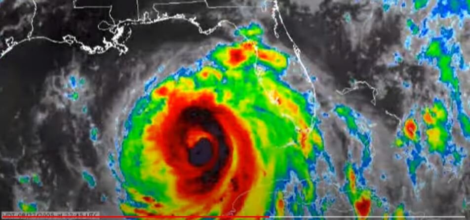
DISCUSSION AND OUTLOOK
----------------------
At 700 AM CDT (1200 UTC), the center of Hurricane Ida was located
near latitude 24.4 North, longitude 85.7 West. Ida is moving toward
the northwest near 16 mph (26 km/h) and this general motion should
continue through late Sunday or early Monday, followed by a slower
northward motion on Monday.  On the forecast track, the center of
Ida will move over the southeastern Gulf of Mexico today and move
over the central Gulf of Mexico tonight and early Sunday.  Ida is
then expected to make landfall along the U.S. northern Gulf coast
within the hurricane warning area on Sunday, and then move inland
over portions of Louisiana or western Mississippi later on Monday.

Maximum sustained winds have increased to near 85 mph (140 km/h)
with higher gusts.  Rapid strengthening is forecast during the next
24 to 36 hours and Ida is expected to be an extremely dangerous
major hurricane when it approaches the northern Gulf coast on
Sunday.  Weakening is expected after Ida makes landfall.

Hurricane-force winds extend outward up to 25 miles (35 km) from
the center and tropical-storm-force winds extend outward up to 115
miles (185 km).

The latest minimum central pressure estimated from NOAA
reconnaissance aircraft data is 985 mb (29.09 inches).
-
Usually as a storm approaches landfall we start to see posts that link to chasers on Twitter, Facebook, YouTube, etc. It would be GREAT to see a collection of chasers that we can follow. I know some people have their favorites that others are not aware of. But please share so we can all enjoy.
Or is there a site that has a list like that? I see this:
https://www.severestudios.com/livechase/
Ida Banter
in Tropical Headquarters
Posted
And rain. Oh the rain.