

NorthHillsWx
-
Posts
3,648 -
Joined
-
Last visited
Content Type
Profiles
Blogs
Forums
American Weather
Media Demo
Store
Gallery
Posts posted by NorthHillsWx
-
-
18 minutes ago, Cheeznado said:
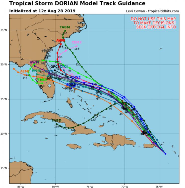
Euro second landfall FL panhandle Thursday.
Right in Michael's impact zone. Thankfully this is a week out and will likely change. A strong ridge north of the storm would certainly push him into the gulf.
-
2 minutes ago, scwxguy said:
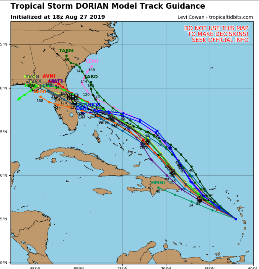
12z Euro has a landfall at 120 hrs/Monday near Ft Lauderdale and Palm Beach Co, then into GOM. This is further south than 00z
Very impressive ridging.
-
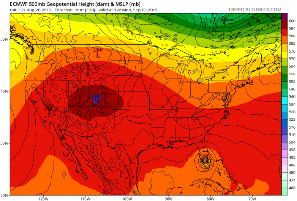
This is really ramping up into a scary situation for the Southeast, again. Dorian was able to avoid all major landmasses, go north of the most hostile shear, develop a core, and now appears to be entering an area of very favorable upper level outflow aided by good divergence from the ULL to the west. Rather than a small system completely re-building its core (track a few days ago) Dorian now has jet fuel to work with and a blocking high that seems intent on sending him into the Southeast somewhere. I think this is the moral of the story today. We are staring at a significant hurricane impact for the southeast. Models seem to be zeroing in on Central/North Florida but I would say anyone up to Hatteras is still in play. Upper air data input into models will start to tell the full tail on that front.
-
 1
1
-
-
Blustery in St. Thomas!
https://www.earthcam.com/world/virginislands/stthomas/?cam=stthomas
-
1 hour ago, NC_hailstorm said:
The Euro has 591dm heights over all of NC,SC,and the eastern half of GA at day 4.It isn't the 594dm death ridge but that is plenty strong and will force it west,it's not coming too far north if it's right.
Heights weaken at day 5 over these areas but its already into FLA by then.Timing and strength of the heights are still in question though.
Yep. Slower = LF further north. Faster = freight train running into FL scenario. Still looks like steering collapses after LF and this thing sits somewhere for a good while and dumps rain. That threat certainly might need to be emphasized in the coming days if these trends continue
-
Just now, FallsLake said:
Again history, storms don't tend to directly hit coastal areas from central Florida to SC/Ga boarder. If I was a betting man I would put money on S. Florida or the SC coast.
Frances and Jeanne say Hi!
-
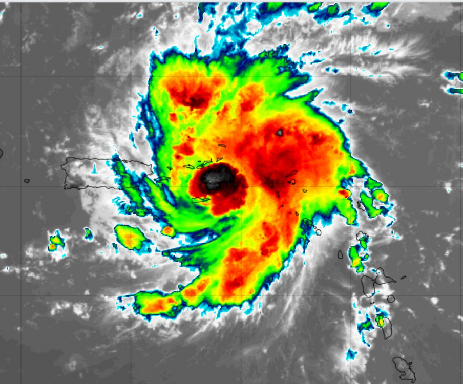
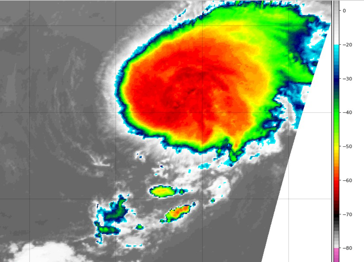
Last Satellite shot is foreboding for strengthening. He finally has that "look" and with the recent blowup right on the center, I wouldn't be surprised to see a period of at least steady strengthening. This is the first real "core" we've seen with Dorian.
-
Not liking the models this morning. Usually a "hint" of a northward move turns into a trend. Someone said it great earlier and I think using Matthew as an analogue is fairly accurate. It all depends on the western extent of the Bermuda High. Forecasting where a storm will round that is one of the most difficult things in tropical forecasting. If this storm slows down it may allow time for the ridge to weaken, then the Matthew-like scenario plays out. I strong ridge sending a hurricane hurdling straight into the Florida coast, like seems to be the consensus on the main board, is certainly a possibility, but the modeling this morning has opened another pathway. A HP with some of the height rises the Euro is showing is certainly impressive and does bring back a setup similar to that of Hugo. Look at the globals for this morning compared to 18z last night and you will see 2 camps setting up... Also, I am on vacation in Nags Head next week so I'm sure it will come to NC... Also, at Duke, we are on storm activation as we have territory pretty much in every place this storm is taking aim at, so I may not have vacation regardless of track!

-
Got up to 82 before clouds moved in. Currently 78, cloudy with a steady NE breeze. Unreal stretch of weather!
-
Spent the weekend with the in-laws and they were convinced a hurricane was approaching NC. I think there is doom-casting (the tweet above) and then also just pure lack of knowledge among many people who do not follow the weather like we do. If they hear about a storm and hear the mention of their state, some people don't listen or just assume it's coming. With the rash of destructive storms the last few years, this may be a side effect. Every storm that forms, people ASSUME the worst now. A cat 1 slamming into Hispanola with plenty of dry and and shear before that is not means to get me overly concerned AT THIS POINT (for SE US impact). As with any tropical system, it needs to be heeded, but anyone predicting any sort of impact at this point is simply spewing.
On Dorian- first of all, he is looking progressively better as of this morning. On Water Vapor, the dry air remains apparent, but it seems he has established a CDO and decent outflow, something with the bursts of convection we had not seen to this point. Given his small size, we know that RI is not out of the question. However, here is what I see:
1) small storm very susceptible to intensity swings
2) Good outflow but shear is certainly not too far to the N and W and very much in the forecast path (see above concerningsize)
3) Opportunity for a brief spinup quickly followed by weakening. Very real possibility we see this thing shoot up to a hurricane but weaken markedly before making it to the islands (if this thing gets sheared apart, it will likely drift west south of the islands in the easterlies and never reach there, as we've seen before)
4) IF and I mean IF this does ramp up to a hurricane, very good chance it is a shell of itself post-land interaction. Even if hit hit as a cat 3 (VERY unlikely) due to its small size, it would likely be a depression (Meaning LF intensity doesn't matter as much as if this was a large storm with broader circulation IE more resilient to a LF or interaction) upon entry to the Atlantic Side
5) We have seen time and time again post land interaction these type of storms struggle to get re-organized. Also, though the shear in that area is light at the moment, there is a TON of time for that forecast to change.
Everything considered, this is a VERY challenging forecast due to small size, dry air, very sharp pockets of shear, degree of land interaction, and environment post-Hispanola. Certainly bears watching but I would not sound the alarm for any threat to the US east coast at this point. I think, as always, the flooding and impact to Hispanola and Puerto Rico (especially post-Maria) needs to be the main news story. Any storm of any intensity causes destruction to these areas and can cause loss of life. Much to come in the coming days.
-
1
-
-
Well the tropics certainly came alive in the last few days! Chantal, weakening depression, a home-grown TS looking likely off the SE coast, potential hurricane (99L) in MDR, and a successive wave train coming off the African coast. Get your popcorn ready.
-
19 minutes ago, downeastnc said:
Yeah temp is 88 DP is 77 heat index is 100 lol......I love NC but man I hate June-Aug outside of thunderstorms.....which I havent had a good one IMBY in ages......I suspect today will follow that pattern again but maybe I will get lucky.
I hear ya! I had been in the same boat for awhile until yesterday saw one storm blow up right over my house and sit, dropping an inch of much, much needed rain, 30-35 mph gusts, and close ctg lightning. Had a good storm a week ago but not as much rain. Can't wait for the, gasp, 70's tomorrow! Hope to see a blossoming radar shortly and maybe a cool, light, drizzly rain type of day tomorrow
-
1 hour ago, shaggy said:
12z 3k nam kills the squall line and shows very few storms. Not sure what's going on with this run.
I haven't been enthused with this setup nearly as much as I was yesterday's. I thought the forecast yesterday way underdid the effect of heating and the MCAPE values were high. Same today but the forcing associated with the front arrives late and very rarely this time of year do nighttime storms reach severe limits, unless you get an MLS situation which this is not. Though dynamics appear most favorable in SE VA and NE NC and this lines up with high CAPE values in prime heating hours and highest shear values in this area as well, I expect a line of storms to progress from NW-SE through midnight. Isolated wind damage for sure but I doubt we see much outside the highlighted areas. That might be what the 3K nam is seeing in its latest run, the line falls apart once peak heating hours wane (though did you see the 6z? That had a significant line. I took that with a grain of salt given other modelling). Should be some good rains. We got an inch yesterday from the storms that developed after that awesome gravity wave cloud (I think that's what it was) moved through.
-
I'm surprised no one mentioned the severe weather from Monday. Drove through the Southwestern side of Raleigh (Centennial Campus Area) and there was a good amount of tree damage (Leaves, branches, and full trees blown down). Seemed like there were several storms of this magnitude around that afternoon so I'd expect similar damage. We had nearly 20k outages that afternoon too and many of our crews worked into the night to get power back on.
-
77 atm. Low cloud cover and it honestly doesn't feel nearly as miserable as last few mornings, oddly, even though DP is still up. That low feature really fell apart moving into NC yesterday. Very little rain in the Raleigh area though some showers worked in west of here, much less convection that NWS was advertising yesterday morning. Models never really brought much rain into here with that feature, so I was surprised they held onto the 50% + chances for so long yesterday. Funny after the active pattern Monday with much greater coverage and storm intensity and only a 20% rain chance!
-
I'm a little surprised the Low that went up the coast was not classified as of this morning. Seems to have, for a period, really gotten it's act together. This screams like one we will hear about in the post-season recap as at least a depression (looks like a storm to me). Thoughts?

-
Worked from home today and was treated to good mid-afternoon storm. Not much wind but pretty good structure, some heavy rain, and close lightning. 0.61" most of which fell rather abrubtly. Humid out this evening for sure
-
11 hours ago, downeastnc said:
the Hi Res models have a interesting little swirl off the NC coast this weekend....
Saw that on the NAM for a few runs now. We've many instances of tropical lows developing right on the coast within a dying frontal boundary almost out of nowhere, though few get beyond depression (or to depression) status. Will be an interesting feature for the outer banks Sun-Mon. Ruined my offshore fishing plans already!
-
0.55" imby from the storm yesterday afternoon and overnight rain. Honestly was expecting more from radar return yesterday but I must have been fringed as we were never really able to keep up the heavy stuff other than a few brief "spurts." Still, anything over 1/2 an inch is a good rain in my book. Mowed my yard twice in last week and half (it had been more than a month since I'd needed to mow it before). Hot outside currently 88 with a lot of humidity. Storm chances have dwindled for the daylight hours today
-
Well, well, well, that walking into a wall of humidity feeling opening the door I had so hoped was gone for the year was back with a vengeance this morning in my neck of the woods! Maybe it seems worse as I had fully thought we were done with this type oppressive heat for the summer (why I get my hopes up in August in the south, I will never know). Oh well, looks like today is the peak of it. I think with strong moisture in low levels tomorrow and the front hanging around, cloud cover will certainly be impressive tomorrow and may be the saving grace for a repeat of today, though it will still be in the miserable range. Mid 80's in the forecast have been replaced with 90's through the period. In my experience with southeast weather during these summer patterns, sometimes it takes a tropical system to fully "break" the cycle and pull a front all the way through the area. Otherwise, looks like more of the same!
-
23 minutes ago, shaggy said:
Hrrr is uninspiring.
Most short-range modelling seems to have backed off on storm chances today from Triangle south. Still seems the storms that do fire will have the potential to be strong, especially with the extreme heat today. We will have to watch the 3-5:00 timeframe closely today to see where storms do fire on the southern outflow from the convection moving through VA and also where localized enhancement takes place. Me thinks a few good storms are possible, though widespread aerial coverage seems lackluster
-
Well, the "wet" period continued overnight. Received and additional 0.22" on top of the 0.16" from the storms earlier in the day for a daily total of 0.38." Really surprised storms were able to keep going overnight, with some strong ones in the Apex area. Seemed the convection earlier in the day had stabilized the atmosphere. Did not feel like it would rain again. I guess the earlier arrival of the first round allowed the full sunshine to generate enough instability that whatever feature that moved through was able to generate, maintain, and even strengthen convection across parts of central NC. Don't see that too often in these patterns overnight in this area. Some areas, my office in Garner included, seem to have really been dumped on overnight. Standing water everywhere
-
Finally got a gullywasher. 1.70" imby yesterday. .04 from the morning's showers and 1.66" from the 2 storms in the afternoon, followed by a long period of cool, light rain. Actually have puddles in the low spot in my backyard this morning
-
Picked up an additional .05" overnight. 1.02" for the day. Great start to August. Let's see if we can get an aerial rain, these summertime pop up patterns can be very unfair over short distances. My farm in Franklin county is DRYYYYY. Food plots are withering, really hope they get something to stay green going into hunting season


Dorian
in Southeastern States
Posted
I said this earlier. If it slows down, it gives more time for it to find a weakness in the ridge. That is exactly what changed overnight. It slowed down a good 18+ hours. Where the western periphery of the ridge sets up is absolutely critical. Also, a slow system + frictional effects with land can end up delaying LF further north as well. We certainly saw this with Matthew. It's only 75-100 miles inland at most on these runs now whereas yesterday many had it going into the gulf. The only good thing about this track is storms that slow and linger on approach to the east coast tend to ingest dry continental air and weaken before LF. It this thing slows to a crawl I would doubt it will come in at peak intensity, especially if it comes north. Obviously that's a sidenote as we saw what Florence (and Matthew) did as a modest 1.